
Please scroll down for the latest, ongoing updates!
Get all the comprehensive weather here:
https://www.marketforum.com/forum/topic/83844/
+++++++++++
Current Hazards at the link below.
For your NWS and county, go to the link below.
Then you can hit any spot on the map, including where you live and it will go to that NWS with all the comprehensive local weather information for that/your county.

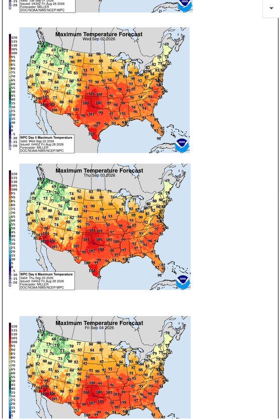
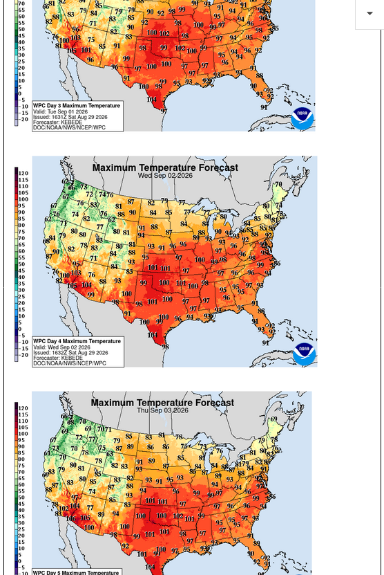
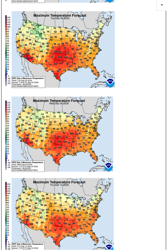
These are highs for next Wed-Thu-Fri in the middle of the heat wave. Upper 90's as far east as Southern IN. The dew points will NOT be as high as our previous heat waves so it will only feel a few degrees hotter, not 10 degrees hotter.
https://www.marketforum.com/forum/topic/83844/#83851
Risk for high heat September 4-10.
https://www.cpc.ncep.noaa.gov/products/predictions/threats/threats.php
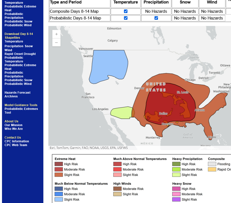
8-28-26:
September 5-11 below.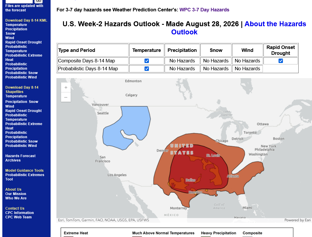
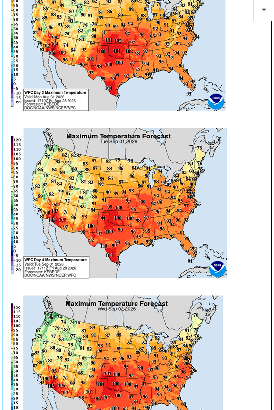
Next Mon-Tue-Wed:
https://www.marketforum.com/forum/topic/83844/#83851
+++++++++++
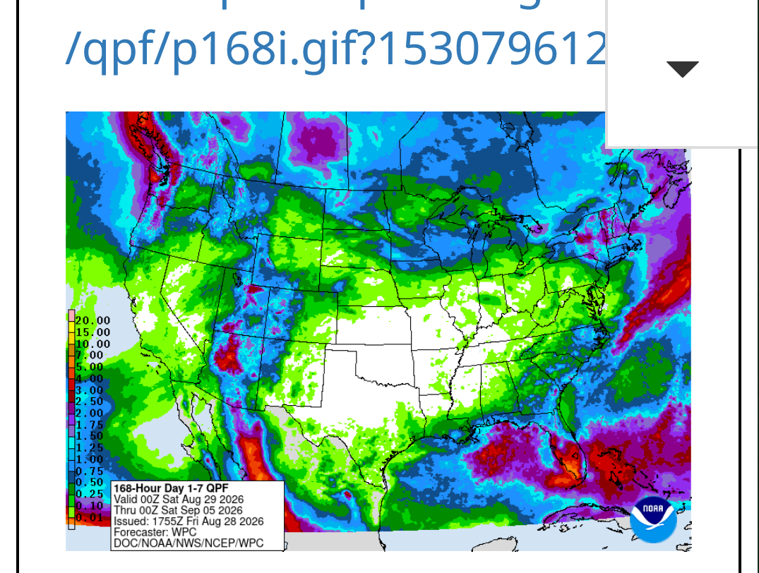
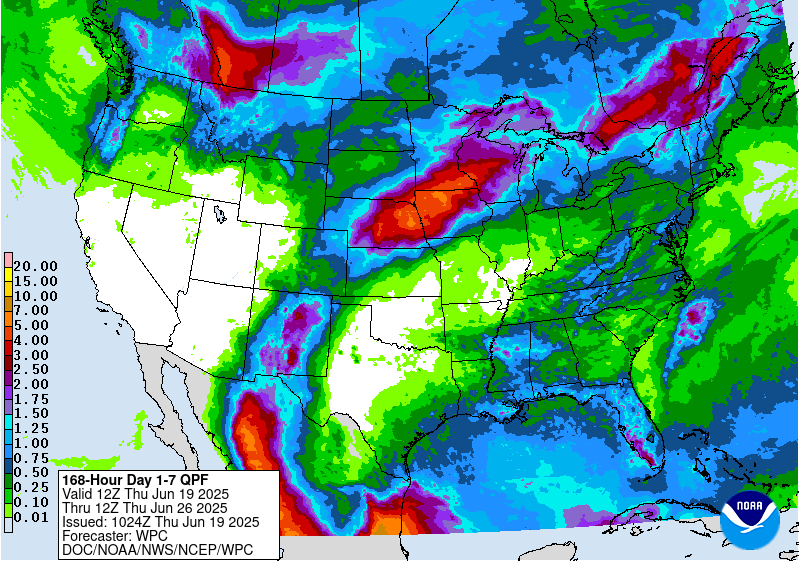
Heat DOME suppressing all chances for rain underneath it.
7 Day Total precipitation below:
http://www.wpc.ncep.noaa.govcdx /qpf/p168i.gif?1530796126
Constantly updated below:
Here's the heat in our local forecast in Evansville, IN.
https://forecast.weather.gov/MapClick.php?x=281&y=88&site=pah&zmx=&zmy=&map_x=281&map_y=88
+++++++++++
To break a high temperature record next week, we need to exceed 101 Deg. F here. With the soils drying out and corn mature and not transpiring(with dew points maybe staying under 70) there's an outside chance of that. The origin of our air masses will be the Southern Plains which is in severe drought. It's there where temperatures will heat up above 100.
https://www.weather.gov/pah/EvansvilleDailyNormalsAndRecords
Please note the record highs for Evansville IN and the year for the next 3 weeks below:
Date Record/year
August
30 99/1951-Actual High=93. Heat Index also 93 with a low humidity!
31 100/1953-Actual High=95. Heat Index 98!
September
1st 101/1953-could be challenged-Actual High=99 hottest of 2026! Heat Index 104!
2nd 102/1953-could be challenged-Actual High=99 Heat Index 106!(a tad more humid than yesterday)
3rd 101/1925-could be challenged-Actual High=99 Heat Index 104! (a tad less humid like Monday)
4th 101/1954-could be challenged-Actual High=
5th 103/1954
6th 104/1925
7th 101/1925
8th 101/1939-could be challenged
9th 100/1939-could be challenged
10th 97/1983
11th 99/1897
12th 99/1897
13th 99/1939
14th 100/1939
15th 99/1939
16th 97/1954
17th 96/1931
18th 98/1953
19th 97/1954
++++++++++++
Looking at the years of the record highs, please note something that stands out.
How many were set since 1990?
ZERO!
9-1950's
6-1930's
3-1920's
2-1890's
1-1983
0-Since 1983
What to understand about this?
1. While I did a bit of cherry picking by selecting ONLY the next 3 weeks, it demonstrates these things:
2. The hottest 2 decades of Summer's in this part of the world were the 1930's and 1950's. Much of this was related to the long lived, widespread droughts before climate change in the Midwest PROTECTED US from widespread droughts and extreme daytime heat.
3. Despite global warming, which is impacting night time temperatures the most, the hottest Summer's in the United States were still in the past. However, Summers in the West, where humidity levels are LESS have become hotter in recent decades because the radiation absorption bands for CO2 and H2O overlap. When H2O nearly saturates those absorption bands, adding more CO2 has much less warming impact. With dry air, CO2 can absorb much more radiation(heat) at those bands.
Re: Re: 6-25-26 MAJOR heat(humidity) wave coming next week
By metmike - July 2, 2026, 1:17 a.m.
4. https://cliffmass.blogspot.com/2016/03/the-golden-rule-of-climate-extremes.html
The GoldenRule
Considering the substantial confusion in the media about this critical issue, let me provide the GOLDENRULE OF CLIMATE EXTREMES. Here it is:
The more extreme a climate or weather record is, the greater the contribution of natural variability.
Or to put it a different way, the larger or more unusual an extreme, the higher proportion of the extreme is due to natural variability.
5. Previous discussion that relates to this:
UAH Global Temperatures for July 2026-hottest in US history
Started by metmike - Aug. 7, 2026, 12:30 a.m.
https://www.marketforum.com/forum/topic/122119/
This was the last AI high temperature forecast for next Tue-Wed-Thu of next week. 99 Deg. F each day in Evansville, IN!!
So the first 3 days of September will be hotter than all the other days in June-July-August.
The mid-day sun angle will be LOWER and less powerful than those previous 3 months. So how does this happen with the same weather pattern that didn't get as hot?
1. Soil moisture has been dried out. With wet/moist soils, some of the heat is used to evaporate the moisture. With dry soils, most of it goes to heat the air.
2. Lower dew points/humidity. Dry air heats up faster(with less heat capacity) compared to humid aid. With a dew point that is around 10 degrees LESS THAN our previous heat waves, next week will not feel AS hot. We peaked out at around 110 for a heat index previously. This time, it may "only" get to 105 for the Heat Index
3. The huge areas of tightly packed corn fields are almost mature and/or drying down and no longer transpiring moisture into the air like they were doing at massive rate earlier in the Summer. They are no longer photosynthesizing and converting the suns kinetic heat energy into stored potential energy in the corn plant.
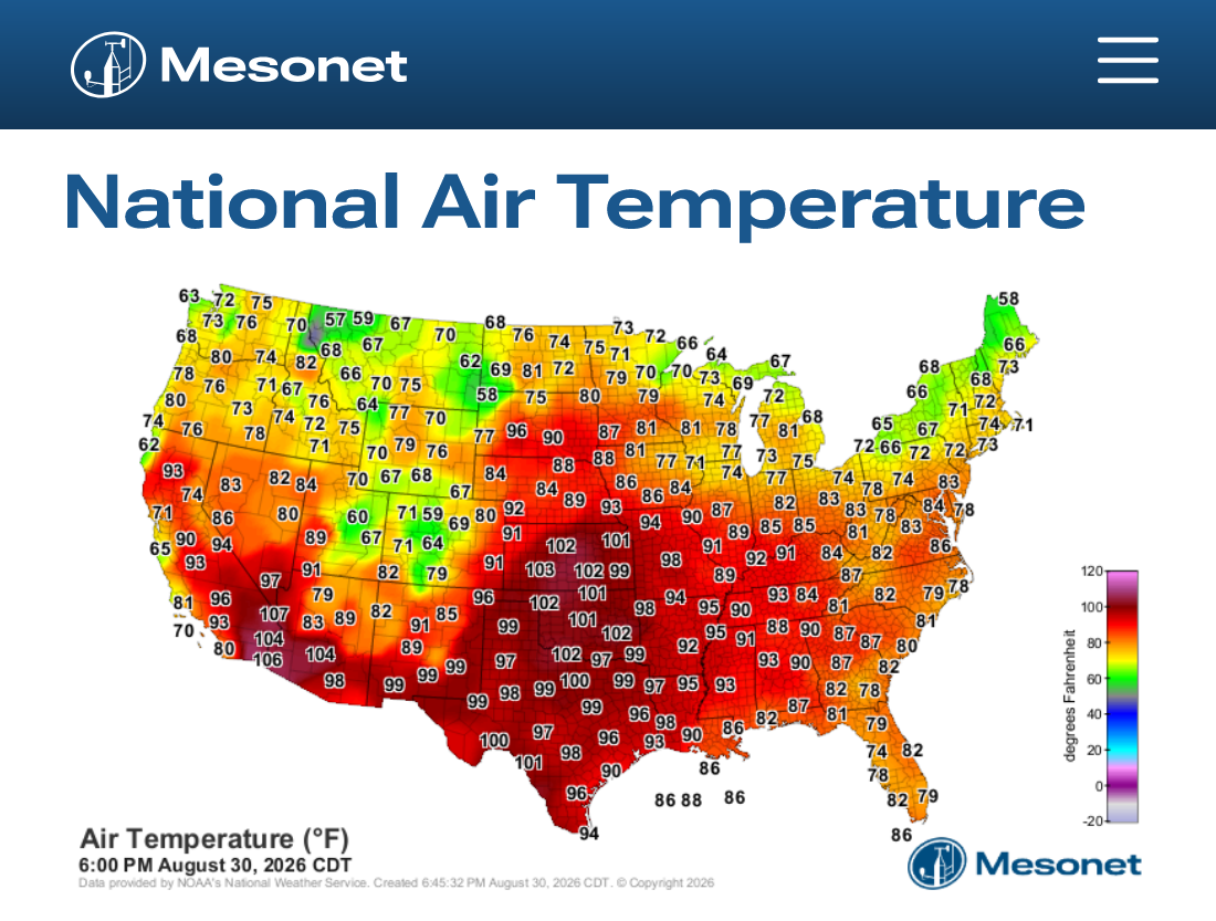
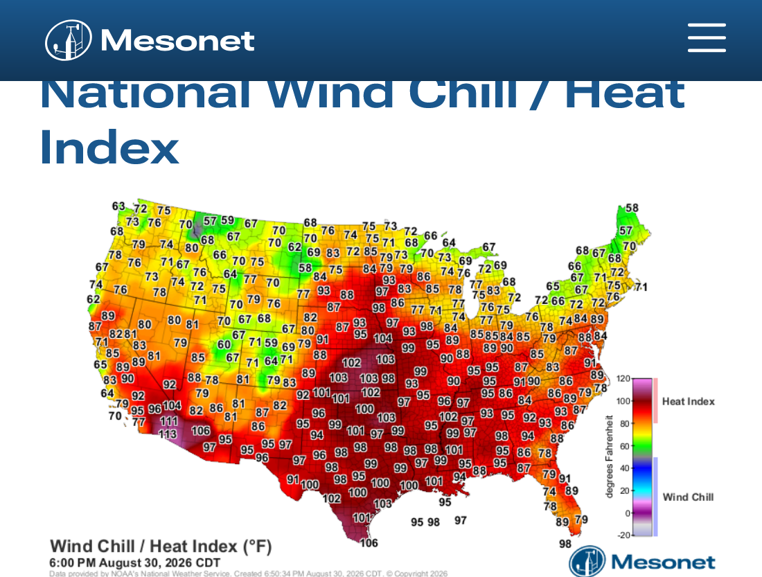
he temperature peaked around 2 hours ago but we still had some major heat at 6pm. Only the start of the next 4 days! Look at the Southern Plains!!!
https://www.mesonet.org/weather/air-temperature/national-air-temperature
https://www.mesonet.org/weather/air-temperature/national-wind-chill-heat-index
https://thermastor.com/dew-point-and-weather-maps/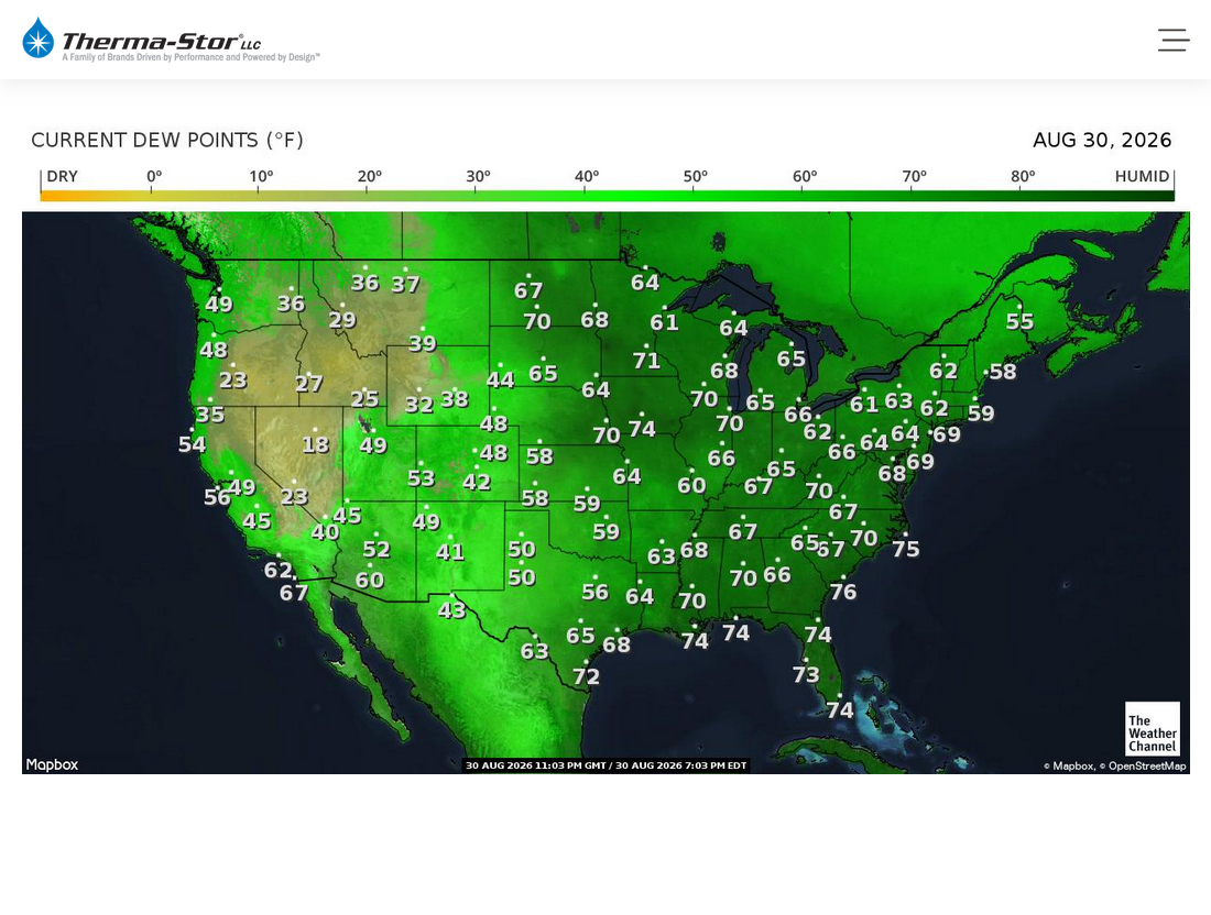
Heat advisory for Evansville, IN on Monday(orange shade below). Likely an EXTREME HEAT WARNING for Tue-Wed-Thu(dark red)!
Current Hazards at the link below.
For your NWS and county, go to the link below.
Then you can hit any spot on the map, including where you live and it will go to that NWS with all the comprehensive local weather information for that/your county.
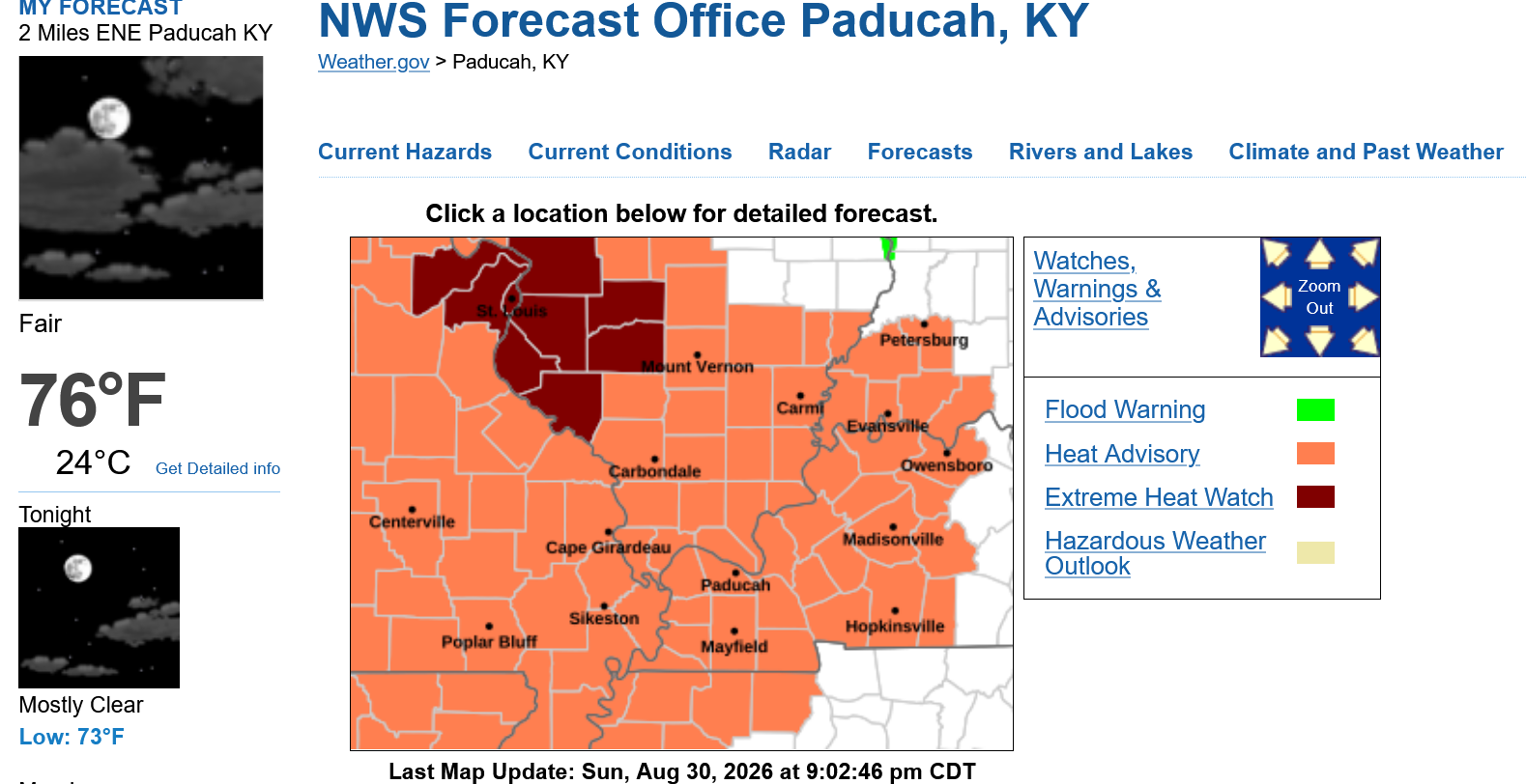
Extended Forecast for
https://forecast.weather.gov/MapClick.php?x=289&y=85&site=pah&zmx=&zmy=&map_x=289&map_y=85
Click here for hazard details and duration
Extreme Heat Watch: Tuesday thru Friday.
Heat Advisory: Monday


Friday
A slight chance of showers and thunderstorms. Sunny and hot, with a high near 97. Calm wind becoming west southwest around 5 mph in the afternoon.
Friday Night
A slight chance of showers and thunderstorms. Partly cloudy, with a low around 73. South wind around 5 mph becoming calm in the evening.
Saturday
A slight chance of showers and thunderstorms. Sunny, with a high near 94. Calm wind becoming north around 6 mph in the afternoon.
Saturday Night
Mostly clear, with a low around 70. Northeast wind 5 to 9 mph becoming light after midnight.
Sunday
Sunny, with a high near 91. Light northeast wind increasing to 5 to 9 mph in the morning.
+++++++++++++=
metmike: Our previous heat waves featured dew points that were HIGHER than this(the mid 70s+) that caused the Heat Index to be as much as 15 degrees higher than the actual temperature. Hitting ~110 at the peak several times.
This go round will feature HIGHER temperatures! So far this Summer, our hottest temperature was 96. We could be at least that hot for the next 5 days, potentially hitting 100 Tue-Fri! However, dew points will be low enough to "ONLY" make it feel around 3-9 degrees hotter most of the time.
STILL DANGEROUS HEAT AND HUMIDITY for vulnerable groups!
Indianapolis, IN
Weather Forecast Office
https://www.weather.gov/ind/heatinfo
For additional weather information beyond heat, please visit our briefing page.
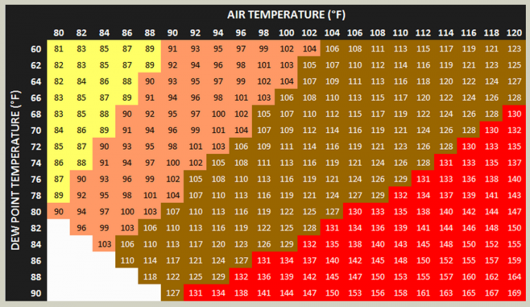
A Heat Advisory means that temperatures of at least 100°F* or Heat Index values of at least 105°F* are expected. Consider postponing or rescheduling any strenuous outdoor activities. If you must be outside, be sure to drink plenty of water and take frequent breaks in the shade. The young and elderly and those with medical conditions should use extra caution outdoors.
An Extreme Heat Watch means that Heat Index values are expected to reach or exceed 110°F* and not fall below 75°F* for at least a 48 hour period. Plan to suspend all major daytime outdoor activities if a warning is issued. If you do not have air conditioning, locate the nearest cooling shelter or discuss staying with nearby family or friends who have A/C.
An Extreme Heat Warning means that Heat Index values are expected to reach or exceed 110°F* and not fall below 75°F* for at least a 48 hour period, beginning in the next 24 hours. A warning may also be issued for extended periods with afternoon heat index values of 105°F-110°F. Refrain from outdoor activities of any nature during the warmest time of the day. Drink plenty of water and take frequent breaks if you must be outside. Stay indoors in an air conditioned building as much as possible. Check on elderly family members if they are living alone.
https://www.wmdt.com/2020/07/heat-index-explained/
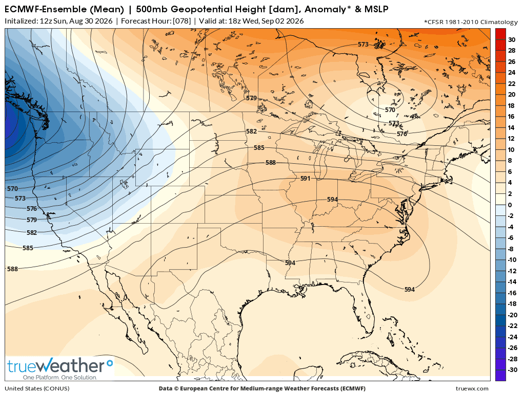
This is what the expansive, rain suppressing heat dome will look like on Wednesday based on the last 12z run of the European Ensemble model. This is 500 mb which is around the mid point of the atmosphere based on its mass/weight. In this case
A 500 mb geopotential height of 594 on a summer weather map corresponds to an altitude of 5,940 meters (about 19,488 feet or 3.7 miles) above sea level.
The hotter it is the less dense the air and the fatter the atmosphere becomes with the 594 contour (for 500 mb) only showing up when the atmosphere has really expanded from HEAT.
Wednesday, August 1, 2026 below:
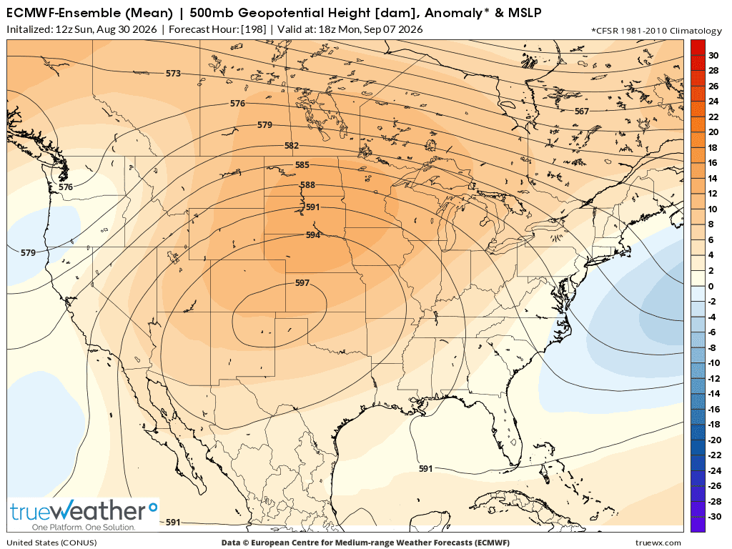
Here is the same map...........but the forecast is for a week from Monday on September 7, 2026. The rain suppressing heat dome has retrograded westward.
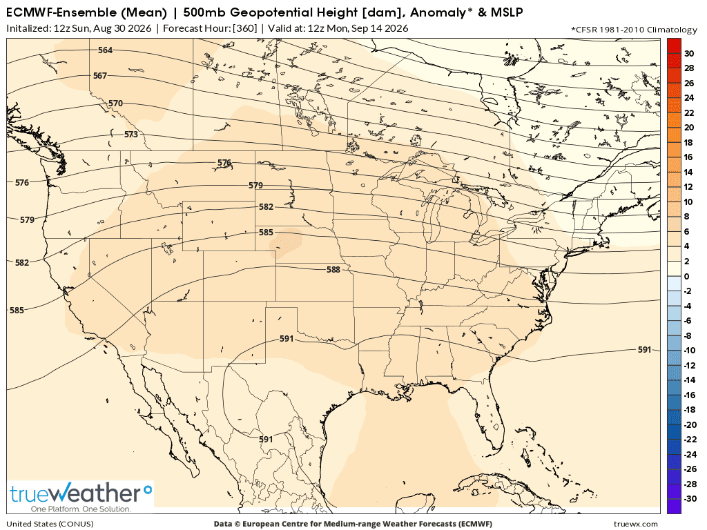
However, the models break this pattern down/flatten the dome/suppress it much farther south and weaken it during week 2. This is the last map, 15 days from now on September 14, 2026.
There is still lingering upper level ridging across much of the country, centered in the Plains
One might wonder why the hottest place right now, the Southern Plains does not have heat advisory's and excessive heat warnings?
AI Overview
++++++++++++++++++++++++++++++
Heat wave well underway now! These are close to the highs, here on Monday!
https://www.mesonet.org/weather/air-temperature/national-air-temperature
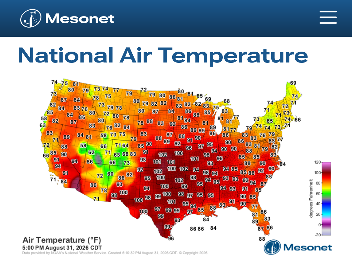
https://www.mesonet.org/weather/air-temperature/national-wind-chill-heat-index
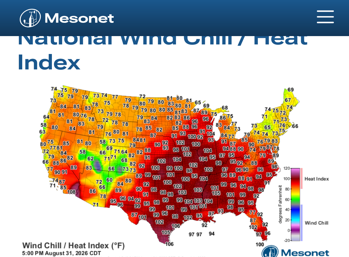
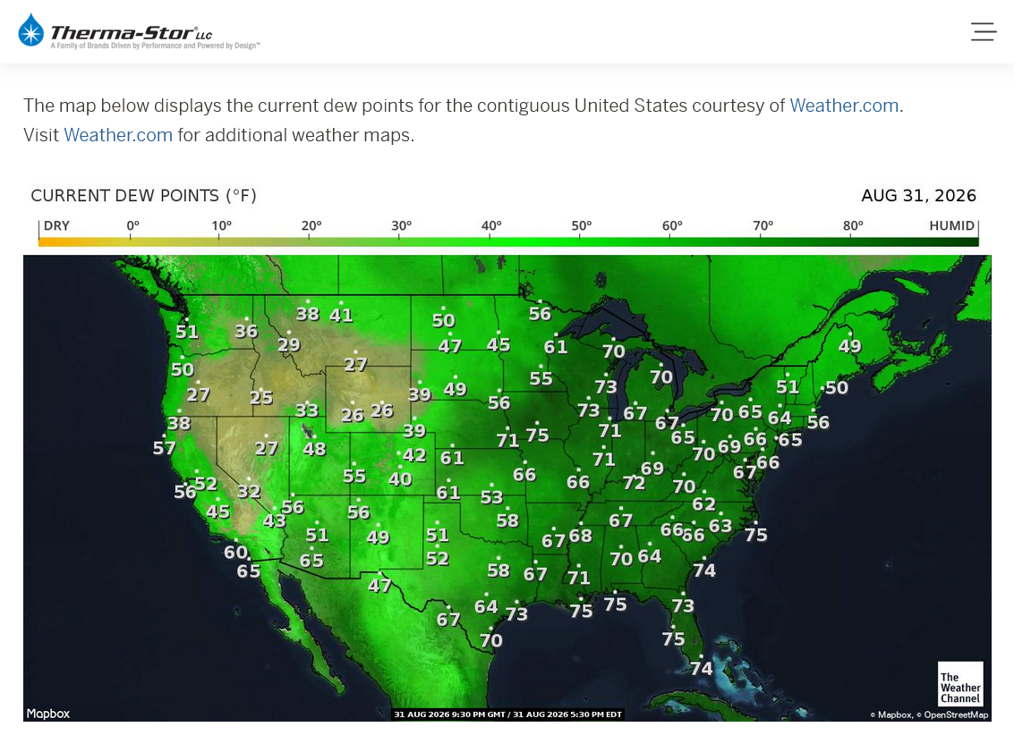
https://thermastor.com/dew-point-and-weather-maps/
The forecast is verifying extremely close.
Re: Re: Re: 8-28-26 Late Summer heat wave
By metmike - Aug. 28, 2026, 11:13 p.m.
Here's the heat in our local forecast in Evansville, IN.
https://forecast.weather.gov/MapClick.php?x=281&y=88&site=pah&zmx=&zmy=&map_x=281&map_y=88
+++++++++++
To break a high temperature record next week, we need to exceed 101 Deg. F here. With the soils drying out and corn mature and not transpiring(with dew points maybe staying under 70) there's an outside chance of that. The origin of our air masses will be the Southern Plains which is in severe drought. It's there where temperatures will heat up above 100.
https://www.weather.gov/pah/EvansvilleDailyNormalsAndRecords
Please note the record highs for Evansville IN and the year for the next 2 weeks below:
Date Record/year Actual High-We predicted no records being broken but getting close on Sept. 1-4.
August
30 99/1951-Actual High=93. Heat Index also 93 with a low humidity!
31 100/1953-Actual High=95. Heat Index 98!
September
1st 101/1953-could be challenged-Actual High=99 hottest of 2026! Heat Index 104!
2nd 102/1953-could be challenged-Actual High=99 Heat Index 106!(a tad more humid than yesterday)
3rd 101/1925-could be challenged-Actual High=99 Heat Index 104! (a tad less humid like Monday)
4th 101/1954-could be challenged-Actual High=100
5th 103/1954-Acual High=100
6th 104/1925
7th 101/1925
8th 101/1939-could be challenged
9th 100/1939-could be challenged
10th 97/1983
The actual temperature is HOTTER this time than our MAJOR heat wave 2 months ago. However, look at the HUGE difference in dew points and the Heat Index(much higher then) directly below. In fact, Evansville, IN tied an all time record for highest dew point when the DP got to 81 Deg. F!!
Also, note the widespread excessive heat warnings below.
With this current heat wave, there are no EXCESSIVE heat warnings this time, just heat advisories.
++++++++++++++++
Re: Re: 6-25-26 MAJOR heat(humidity) wave coming next week
By metmike - June 30, 2026, 5:28 p.m.
Thanks, Patrick!
These are the current excessive heat warnings for a heat index of 110+
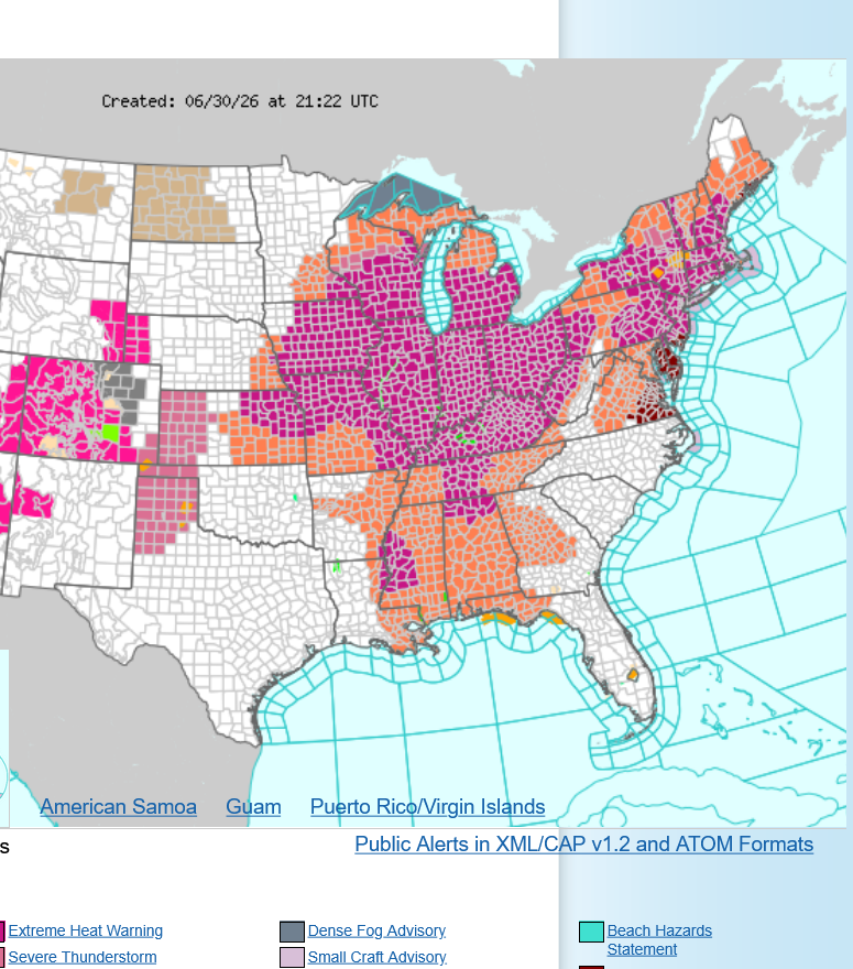
At the peak today, 4pm below we can see that almost none of those locations have reached a heat index of 110 degrees.
It's hot and especially humid but for the area below, temperatures in the low 90s are typical Summer heat.
INCREDIBLY HIGH DEW POINTS!!!
%20wave%20coming%20next%20week%20-%20MarketForum.png)
The high temperature today in Evansville, IN was 92 degrees. This is 4 degrees above the average of 88 degrees for June 30, 2026. Our highest heat index so far this week has been 107 deg. F.
The RECORD high for today was 106, set in 2012.
+++++++++++
9-1-26: Compare this to the last dew point map below. The color scheme of the maps is not good for discerning HIGH dew point disparities but just note the 50's and 60's in the Southern Plains below, the origin of this air mass (Sept. 1) compared to the map above, June 30, where DP's were 10 degrees higher in some of those same spots.
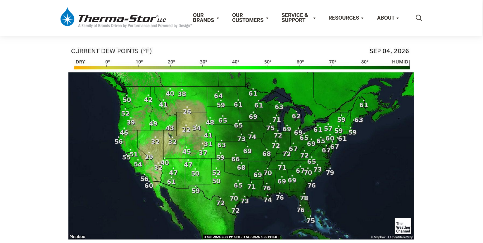
https://thermastor.com/dew-point-and-weather-maps/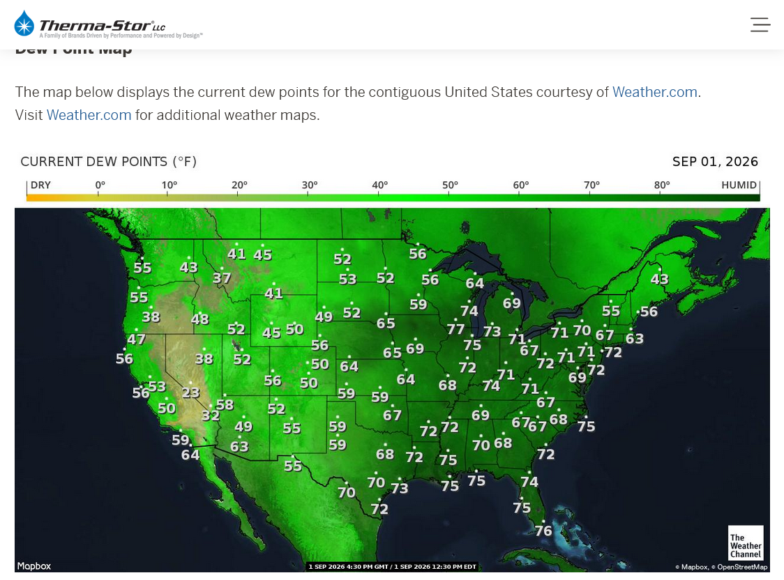
Our NWS just upgraded to an Extreme Heat Warning!!!
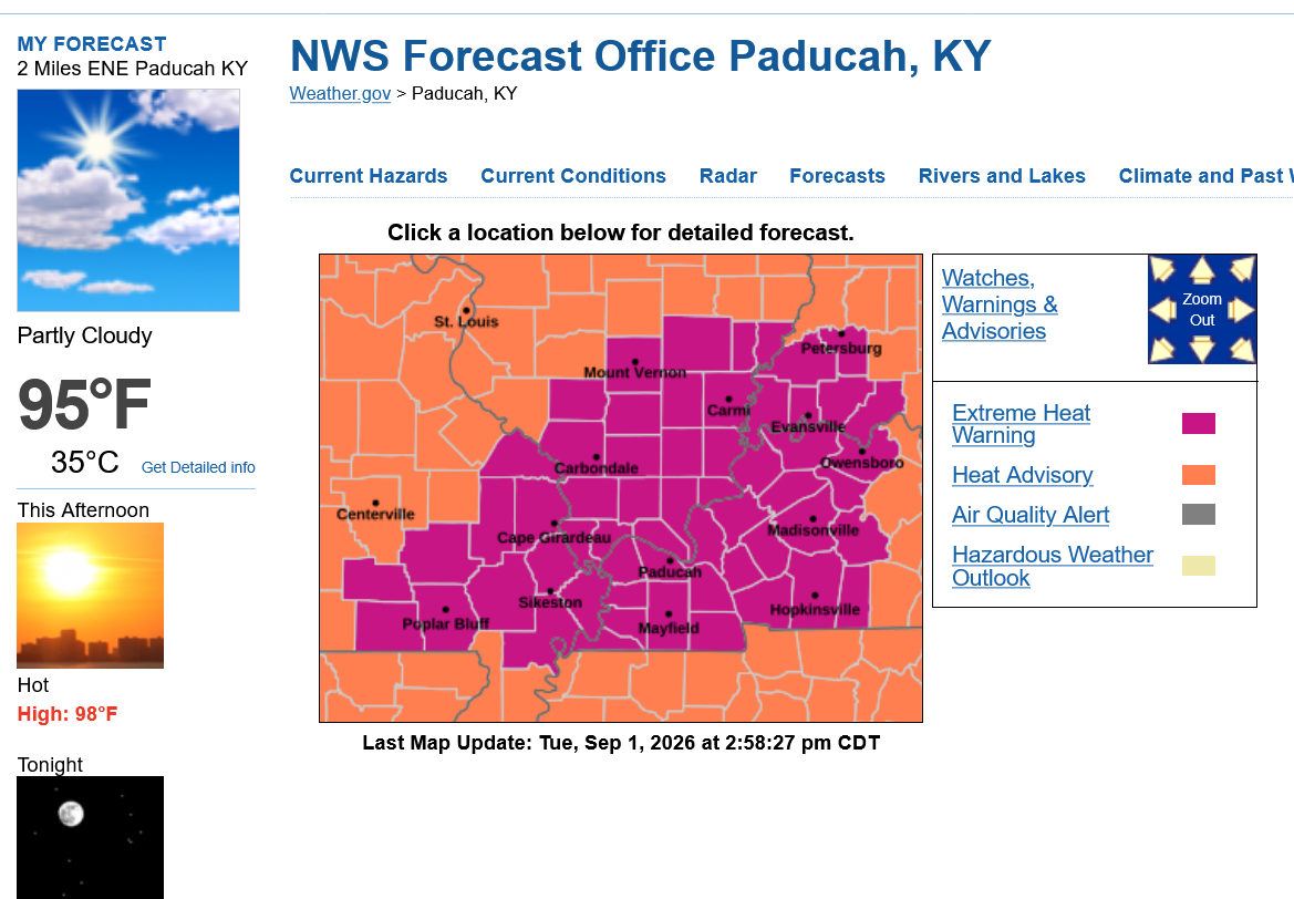
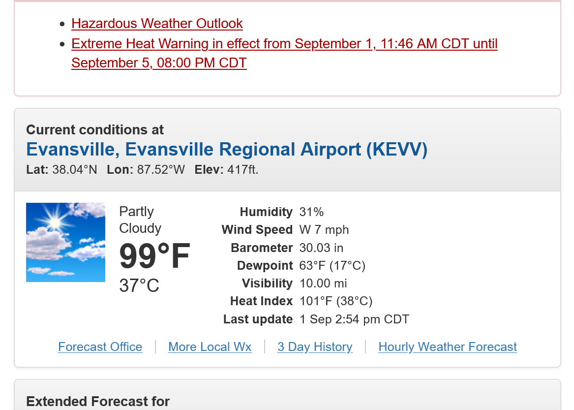
Please note that with the 99 Deg. F reading at 3pm, the dew point down at just 63 Deg. F, meant that the Heat Index is just 101 Deg. F. So it only feels 2 degrees hotter. 2 months ago, when we were close to 95 Deg. F, the Heat Index at times was close to 110 Deg. because the dew point was close to 80 at times.
+++++++++++++++++++++
Still near peak heat here at 5pm, Tuesday September 1, 2026. Hottest day of the year for our region!!!!
https://www.mesonet.org/weather/air-temperature/national-air-temperature
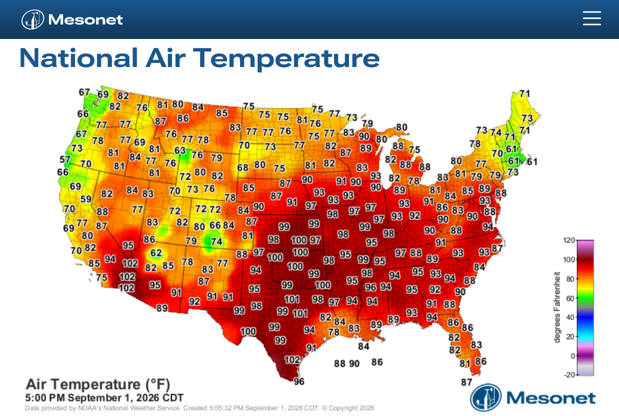
https://www.mesonet.org/weather/air-temperature/national-wind-chill-heat-index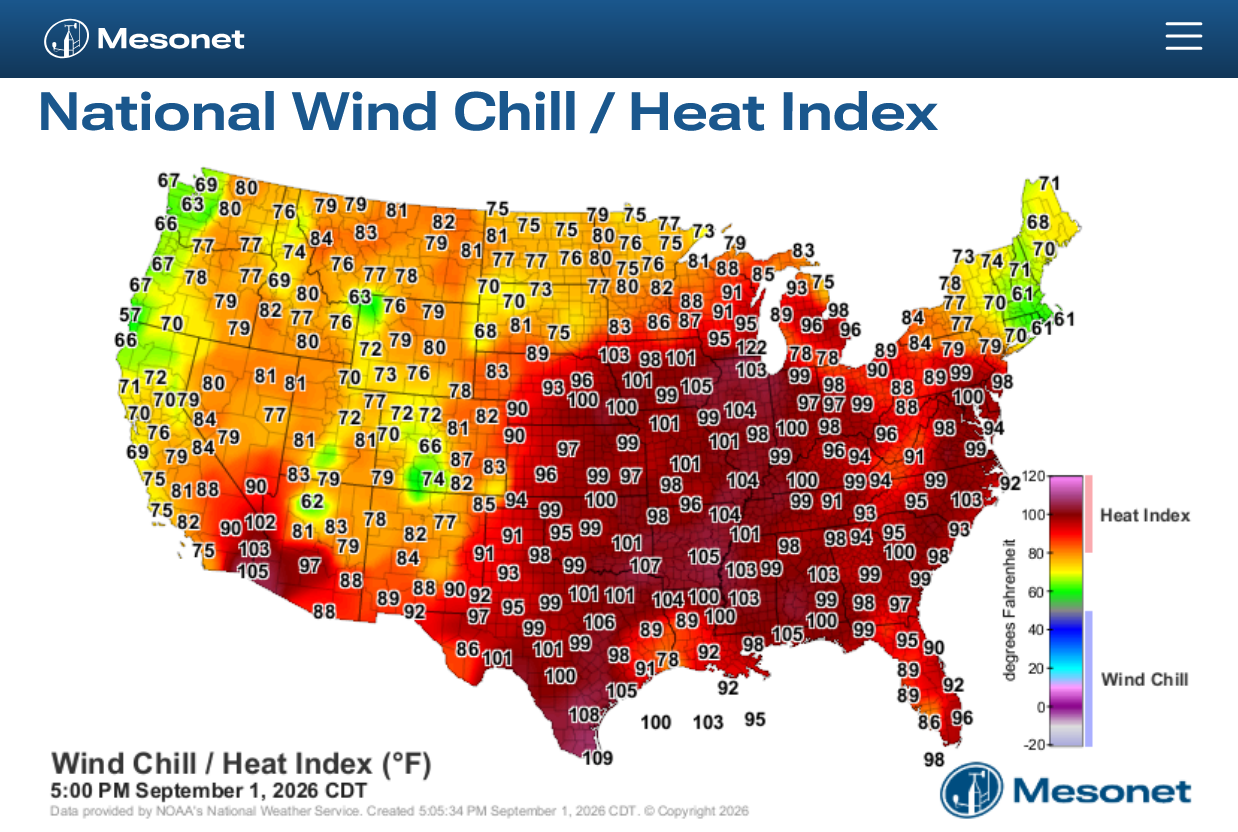
https://thermastor.com/dew-point-and-weather-maps/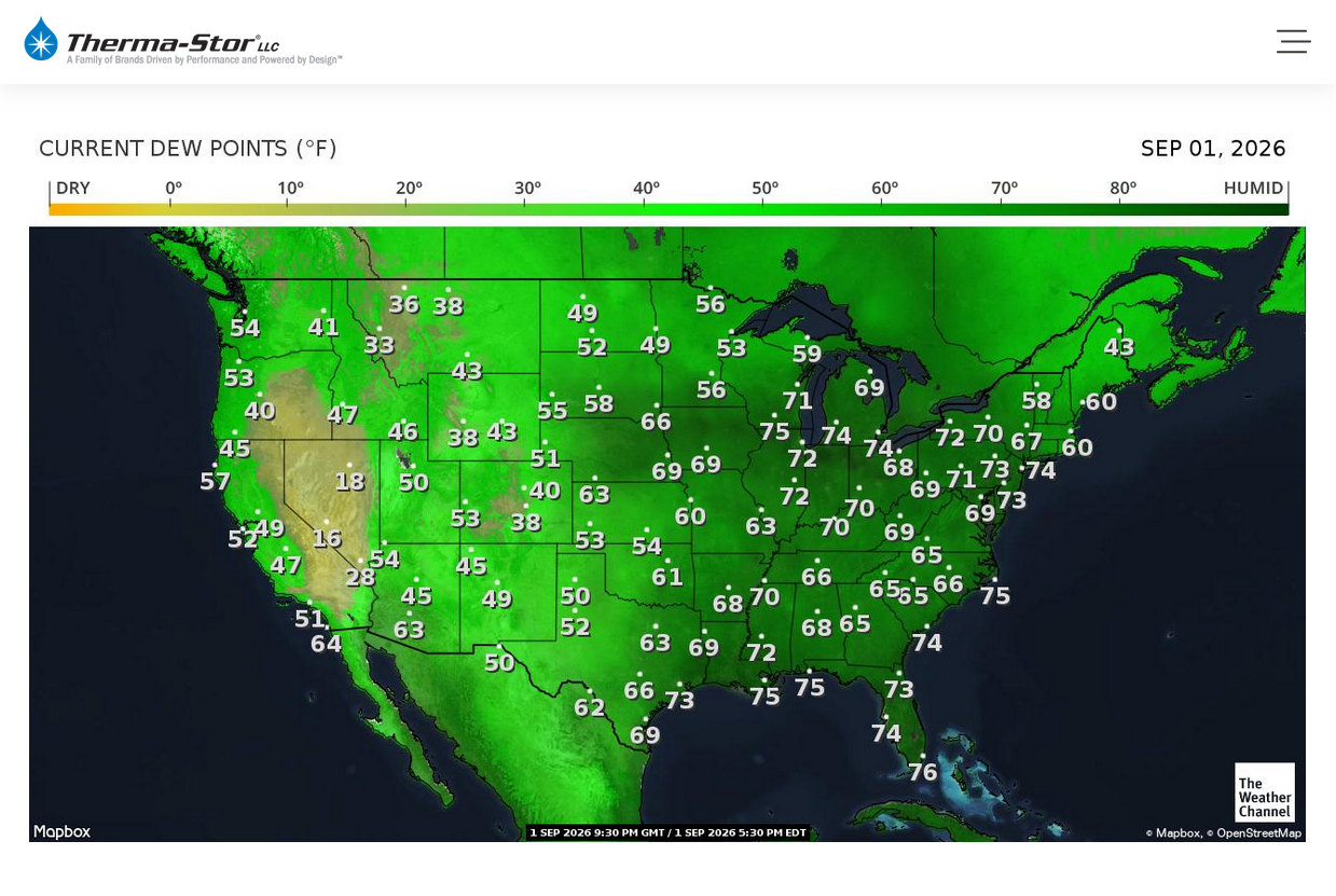
+++++++++++++
One thing that is happening is that the origin of this air mass is the Southern Plains with its bone dry soils, being transported in with dry southwest winds.
That is why this air mass has dew points in the 60's and the the 70's.
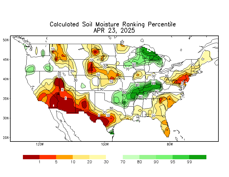
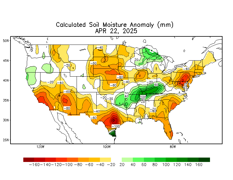
That, along with our soils dried out is also why temperatures are flirting with 100 Deg. F. Dry air has less heat capacity and is heated faster/more than humid air. With wet soils some of the solar radiation is used to evaporate H2O into the air compared to mostly heating the air above the ground with dry soils.
https://www.cpc.ncep.noaa.gov/products/Soilmst_Monitoring/US/Soilmst/Soilmst.shtml#
All outdoor athletic events were cancelled in Illinois by IHSA (Illinois High School Association) based upon a temp of 90 or more with a heat index of 100 or more. Probably tomorrow also.
Thanks very much for letting us know from our western sister state, tjc!
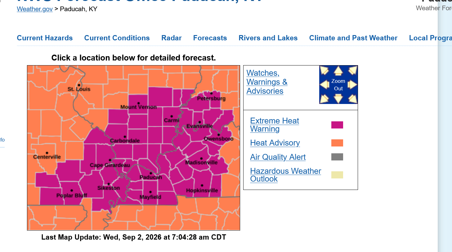
Our extreme heat warning continues with a predicted high of 100 the next 3 days:
Click a location below for detailed forecast.
++++++++++++++++++++++
Most areas, however are just below the extreme heat warning criteria and have a heat advisory:
Lack of high dew points/humidities will reduce the impact to humans(allow our bodies to more effectively cool from sweat evaporating compared to the previous heat waves this year) but will dry out vegetation faster! That's the message that I just posted on Facebook and X.
++++++++++++++
This heat dome is NOT going away!!!
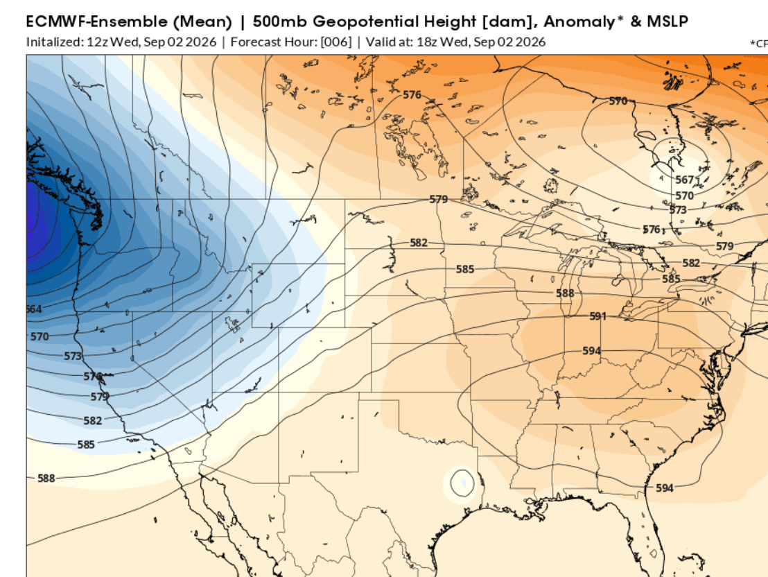
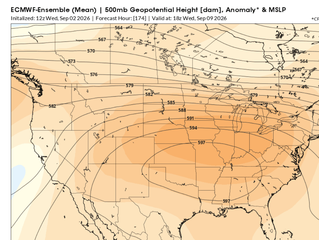
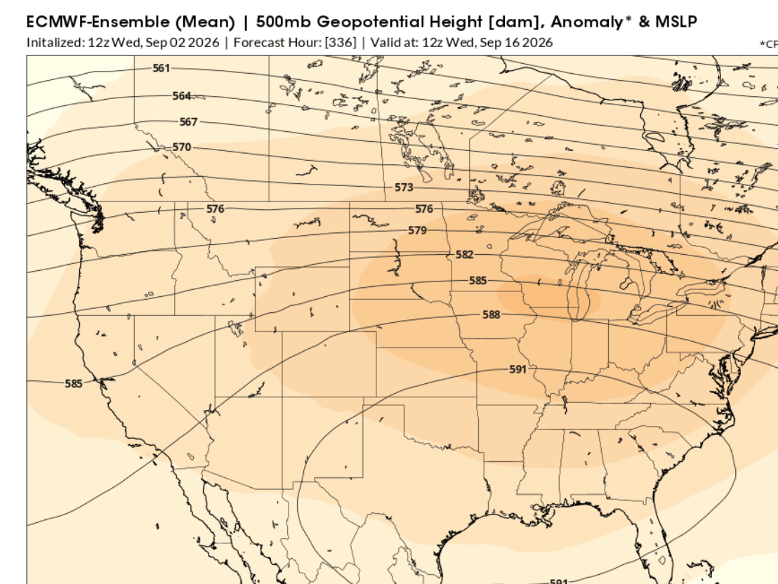
This is what the expansive, rain suppressing heat dome looked like today, September 2, 2026 based on the last 12z run of the European Ensemble model. This is 500 mb which is around the mid point of the atmosphere based on its mass/weight. In this case
A 500 mb geopotential height of 594 on a summer weather map corresponds to an altitude of 5,940 meters (about 19,488 feet or 3.7 miles) above sea level.
The hotter it is the less dense the air and the fatter the atmosphere becomes with the 594 contour (for 500 mb) only showing up when the atmosphere has really expanded from HEAT. Maps below
1. Wednesday(today) September 2, 2026: 594 closed contour.
2. Wednesday, September 9, 2026: 597 closed contour!!
3. Wednesday, September 16, 2026. Massive 591 contour! However, longer range models rarely dial in extremely anomalous temperatures accurately. They gradually revert towards the climatological average with time and they slowly lose skill to discern between that and the extreme weather coming up!!! So odds are high that it will be hotter than this forecast with the same pattern. And the pattern could change completely too!!!
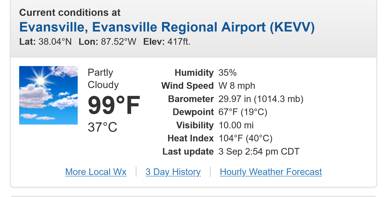
And the heat goes on. This was 3pm.
Looks like our high for today. Heat Index of 104 makes it feel hotter but not AS high as the Heat Index earlier this year with other hot days in the mid and even low 90's because dew points were 10 degrees higher then.
++++++++++++
https://www.buddhabeeapiary.com/blog/honey-bee-temperature-regulation
+++++++++
This is amazing!
https://www.noaa.gov/education/explainers/can-crickets-tell-temperature-answer-is-in-their-chirp
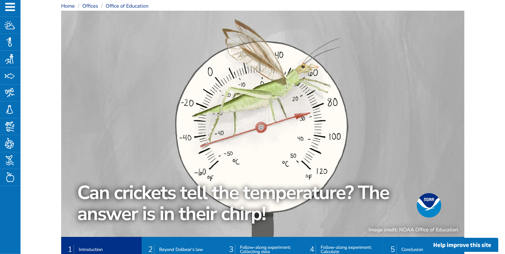
Exploring Dolbear's law.
Temperature (F) = number of cricket chirps in 15 seconds + 40
More of the same! Relief on Sunday and especially Monday when temperatures will be 10 deg. cooler!
But back into the frying pan in the middle of next week!
Get all the comprehensive weather here:
https://www.marketforum.com/forum/topic/83844/
Current Hazards at the link below.
For your NWS and county, go to the link below.
Then you can hit any spot on the map, including where you live and it will go to that NWS with all the comprehensive local weather information for that/your county.
https://www.youtube.com/watch?v=iLIg8DGR06w
++++++++++++++++++++
For our region in Evansville, IN:
https://www.weather.gov/pah/August2026ClimateSummary
+++++++++++++++
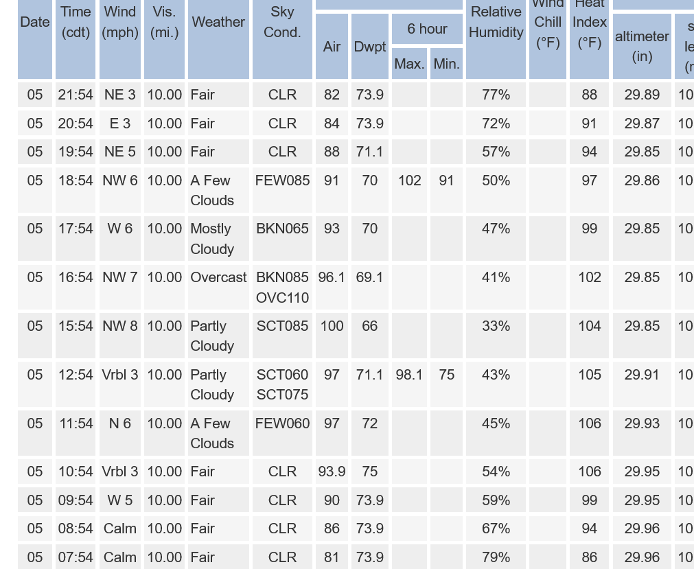
It's been 99 the past 2 hours with a heat index of 107 at Noon and 1pm, then 106 the past 2 hours.
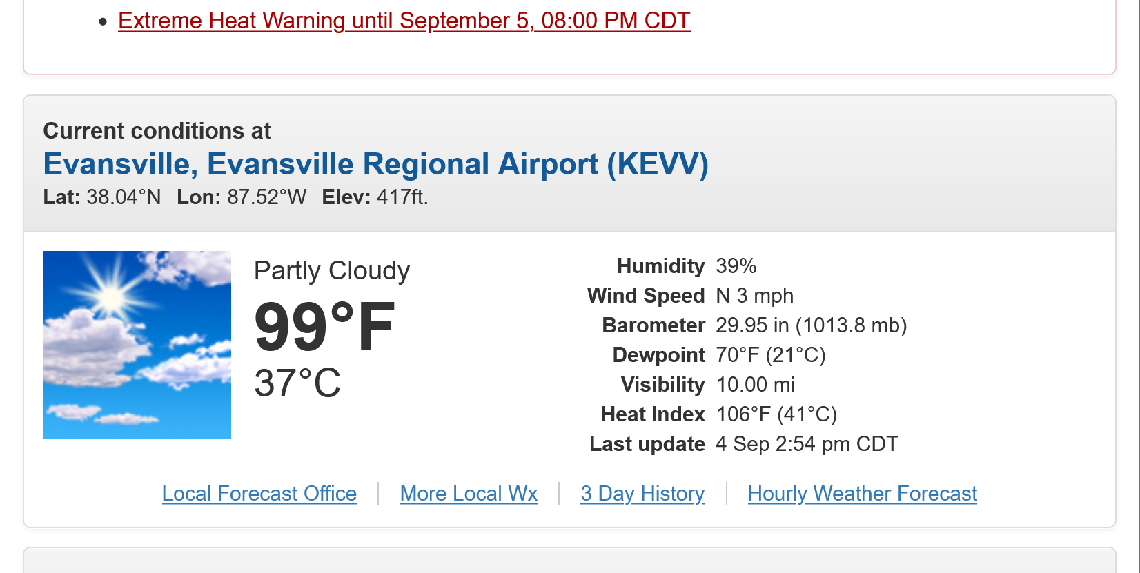
We finally hit the century mark at 4pm! Hottest temperature of the year. Heat Index is 108( it was higher numerous times earlier this Summer in the more humid air masses then).
https://forecast.weather.gov/MapClick.php?x=291&y=93&site=pah&zmx=&zmy=&map_x=290&map_y=92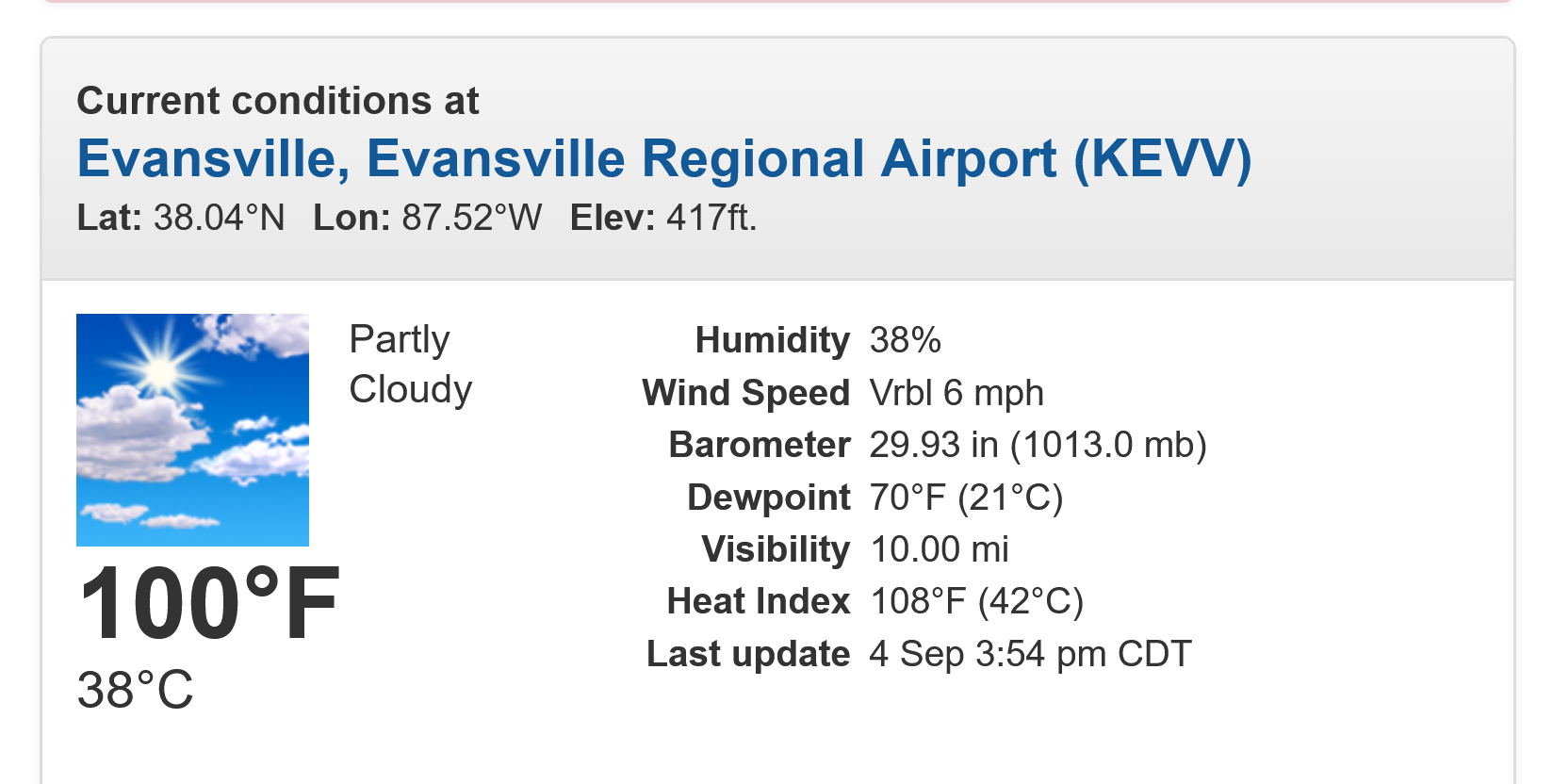
+++++++++++
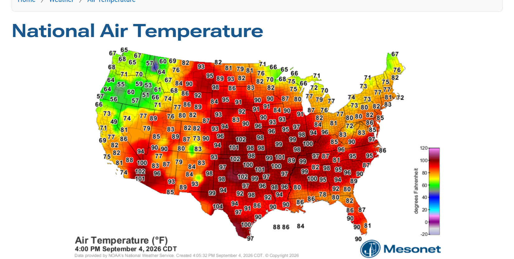
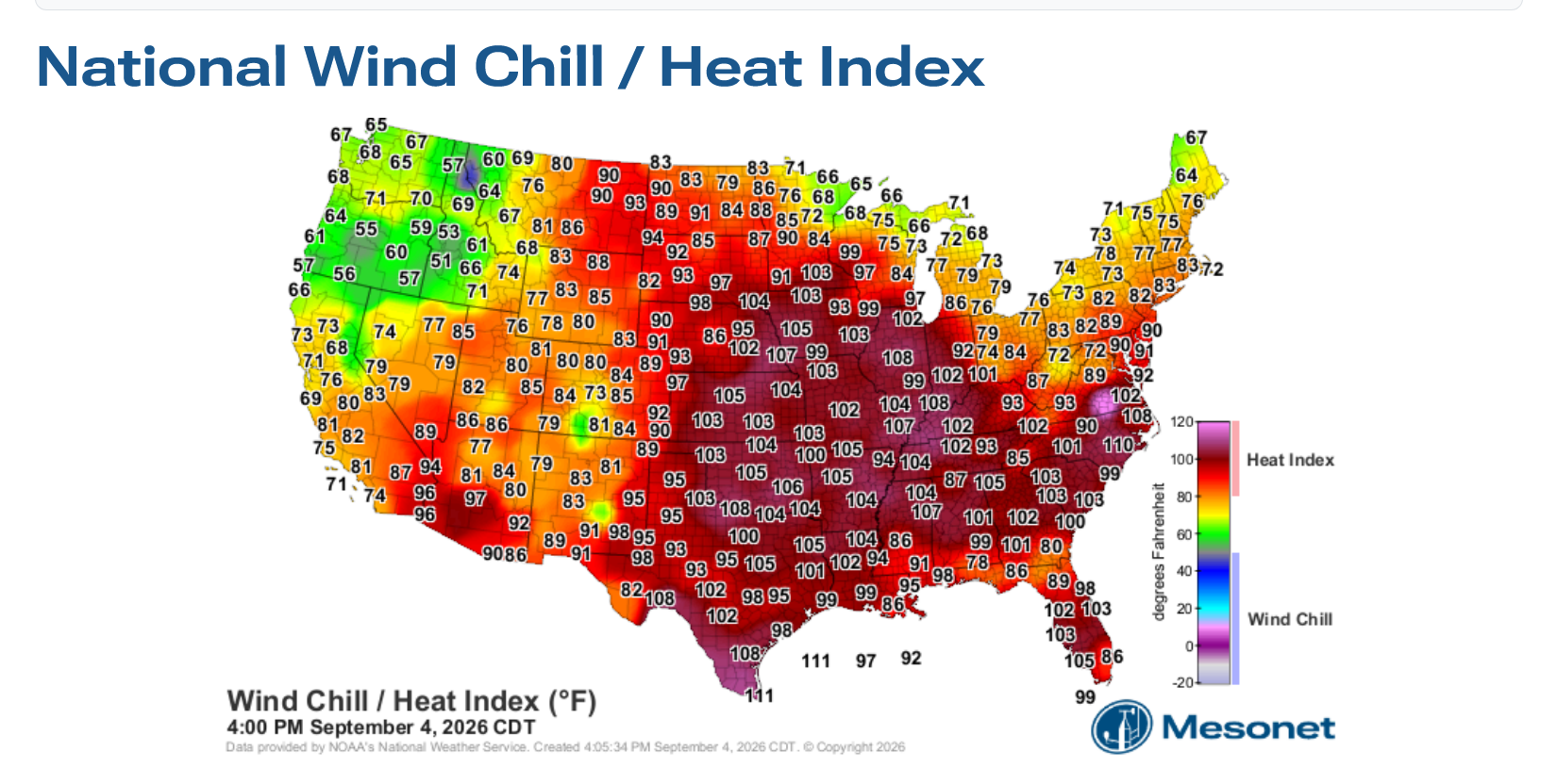
Here' the rest of the country at 4pm:
https://www.mesonet.org/weather/air-temperature/national-air-temperature
https://www.mesonet.org/weather/air-temperature/national-wind-chill-heat-index
https://thermastor.com/dew-point-and-weather-maps/
After cooling off around 10 degrees on Sunday, we go back into the furnace again next Tue-Wed-Thu before the next cold front takes down the heat.
https://www.marketforum.com/forum/topic/83844/#83851
We hit 100 degrees for the 2nd day in a row. Our Evansville "Pumpkins" 3-4 year old T-Ball team had an early practice at 8am when the temperature was only 81 degrees!
https://forecast.weather.gov/data/obhistory/KEVV.html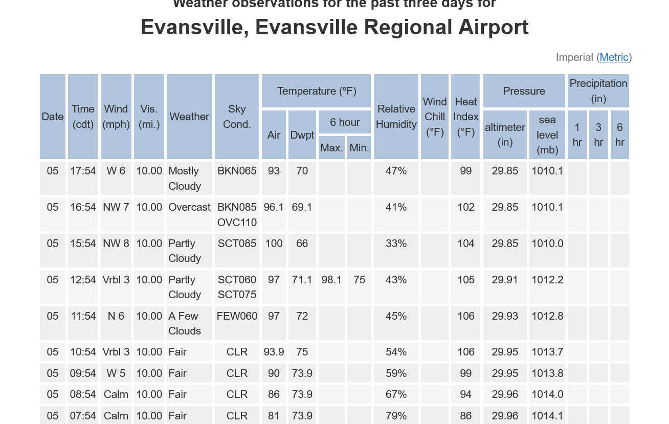
https://www.youtube.com/watch?v=l9ml3nyww80
++++++++++++
From previous post:
https://www.weather.gov/pah/EvansvilleDailyNormalsAndRecords
Please note the record highs for Evansville IN and the year for the next 2 weeks below:
Date Record/year Actual High-We predicted no records being broken but getting close on Sept. 1-4.
August
30 99/1951-Actual High=93. Heat Index also 93 with a low humidity!
31 100/1953-Actual High=95. Heat Index 98!
September
1st 101/1953-could be challenged-Actual High=99 hottest of 2026! Heat Index 104!
2nd 102/1953-could be challenged-Actual High=99 Heat Index 106!(a tad more humid than yesterday)
3rd 101/1925-could be challenged-Actual High=99 Heat Index 104! (a tad less humid like Monday)
4th 101/1954-could be challenged-Actual High=100. Heat Index 108!
5th 103/1954-Acual High=102. Heat Index 106!
6th 104/1925
7th 101/1925
8th 101/1939-could be challenged
9th 100/1939-could be challenged
10th 97/1983
+++++++++++
I stand corrected on the high today! Our local NWS has been having serious instrumentation issues the past 3 weeks and did not report information for 2pm or 3pm below. 12:54 =1pm readings, then the next one was 15:54 = 4pm readings.
9-6-26 Finally MAJOR Heat relief in sight!!!
Started by metmike - Sept. 6, 2026, 9:45 a.m.
Summary of Aug 31 - Sep 5, 2026 heatwave
Paducah, KY
Weather Forecast Office