
s-c-w appear to have put in a "temporary" resistance area overnight (yet bean oil, o, and rice surged).
I am looking for a retracement, probably significant, to try the long side.
MetMike is QUIET
NG and BOIL have renewed upside since early this morning.
VERY interesting markets!
I have first resistance for Dec corn at 4.70 High so far 4.6125
China bought some yesterday.
Soybeans pushing against the psychological $12.00 mark
Boil ,I have a sloping down trend line currently at 28.88 and sloping about .19/day resistance. support at Friday's low at 25.60
Previous thread here:
Grains/USDA report 6-30-26
Started by metmike - June 30, 2026, 3:39 p.m.
https://www.marketforum.com/forum/topic/121257/
+++++++++++++
Get all the comprehensive weather here:
https://www.marketforum.com/forum/topic/83844/
+++++++++++++++
More info in a short while. This just looks like a pause after we dialed in, almost the entire new pattern change in 1 day. This happens alot. Markets don't go up X/day in price in weather markets. They go up in huge XX surges in 1 day, when everybody sees the same thing at the same time and all want to buy(sell) on the same day......then have pauses, corrections or smaller increases(decreases) of X on all the other days...........as everybody waits for the latest weather updates to trickle in, with individual model updates around the clock and NWS rain/temp outlooks(their interpretation of the already release model updates).
Here's their last 7 day rainfall forecast (most of it in the next 5 days, before the DOME takes over this weekend, lasing several days, then backing out, much farther west next week.
7 Day Total precipitation below:
http://www.wpc.ncep.noaa.govcdx /qpf/p168i.gif?1530796126
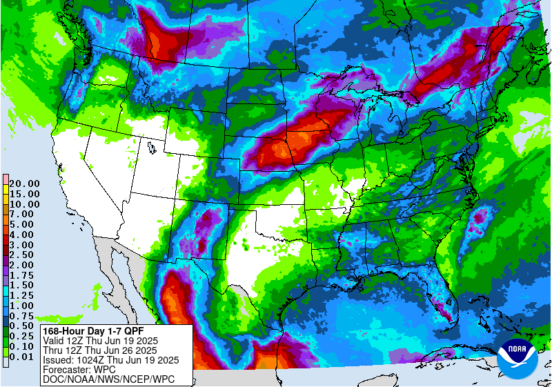
What we know with certainty. That includes the market already dialed it into the current price.
1. The rains above will completely shut down at the end of this week.
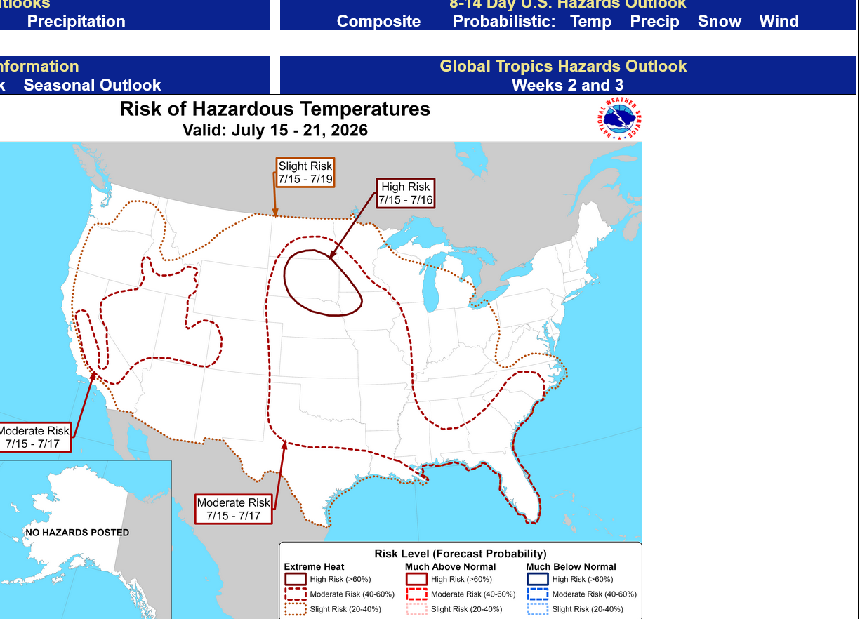
2. The very impressive heat dome will last several days with 100 degree heat in the Plains to WCB and NO RAIN ANYWHERE for those several days.
3. That dome backs west after that and the most bullish weather will definitely be in the WCB, closer to the dome.
What we don't know and will determine where the price goes.
1. Rain amounts this week. This is a minor factor that will cause a short term, knee jerk reaction that lasts a few hours.
2. After the dome retreats/retrogrades ,what will be the pattern? This means everything. The European Model extended forecast has been extreme bullish for the WCB for the rest of July with high heat and almost no rain. The ECB, however could have decent rains and not much heat.
Also, their could be ridge riding perturbations coming around the periphery of the dome that models can't forecast, especially in the potential northwest flow dropping into the Midwest.
The market has gone from being skeptical last week to believers this week because of how impressive this huge dome will be early next week( though is only lasts for a few days)
Here it is, for next Tuesday(1 week) from the 12z GEFS which is still not thru week 2 yet. That is very unlikely to be able to stay there. If that was in the forecast suddenly, we might be limit up today. Chances of it staying as a "Dome of Death" appear to be around 10% (wild guess).
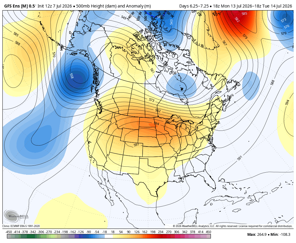
What the market cares about for NEW INFORMATION IN PRICE DETERMINATION is where that feature migrates to and parks itself.
The latest guidance takes it more into the Southern Plains instead of the Southern Rockies.
This was the last 12z Canadian ensemble AVERAGE model(top-the average does best over time) with it's individual ensembles included so you can see the uncertainty of where that dome could go in 2 weeks.
My opinion?
I'm smart enough to know what I don't know. Too many uncertainties. Moist soils/evapotranpiring corn and an El Nino favor a more bearish scenario than what models think but they always catch on eventually( like they did over the weekend to this huge dome pictured above).
The European model performs the best but the skill of every extended model is low compared to a week 2 forecast. The EE model has been forecasting this turn to hot/dry since May(when it was supposed to happen in mid June). Maybe it will end up right?
https://weather.gc.ca/ensemble/charts_e.html?Hour=384&Day=0&RunTime=12&Type=gz
384h GZ 500 forecast valid on Jul 23, 2026 12 UTC


Forecasts for the control (GEM 0) and the 20 ensemble members (global model not available)
++++++++++++++=
There are 2 ways to look at this pattern with regards to whether it will hurt the corn or beans more.
1. There is no widespread drought in the Cornbelt right now in early July. This is especially good for corn pollination, even if rains shut down later this month. However, temperatures getting very hot early next week in the WCB will be bad for pollination which will be taking place in many of those spots.
2. August weather is the most important for beans because its pod fill month. If we turn dry in July, by the time we get to August, there WILL BE widespread drought which will be BAD for pod filling beans.
3. After pollination of corn, temperatures matter a great deal. Corn matures based on growing degree days, regardless of good rains. The best corn crops always feature Summer that don't have well above temps, regardless of abundant rains. The cooler it is, the longer it takes the plant to mature(before global warming/climate change, we worried about an early frost during cool Summers). The longer you can extend the maturation process, the more time the plant will be using sunshine, CO2, water/minerals via photosynthesis to pump nutrients into plump kernels that equates to huge yields. If your shorten that time with accelerated maturation from heat , the kernels don't have as much time to fill. That's why we call it HEAT FILL.
Here's our best thread for explaining and illustrating this principle:
HeatFill for Corn
Started by metmike - July 14, 2023, 2:47 p.m.
https://www.marketforum.com/forum/topic/97257/
The market KNOWS THIS below and dialed it in with yesterdays huge spike up/break out to the upside.
This is a weather market trading future weather. This extreme heat event can remain pretty bullish as we get closer and support prices as long as the pattern after that doesn't morph into being bearish.
Then, the market will shrug off a 5 day heat wave with no rain in the middle of July(consider it already baked into the price) and start trading what comes after that.
Regardless, this very impressive DOME has got the market's attention and its gone from a market, last week that ignored the most bullish weather forecasts (that didn't have a dome this powerful) and instead, focused on the bearish forecasts/models and good soil moisture and decent crop ratings......to a market that is ultra sensitive to weather model updates, knowing that even if/when the dome retreats, it will dry out soils and put additional stress on the crops which WILL NEED rains in late July or start to decline.
A weather market is trading crop conditions in 2, 3 and even 4 weeks from now. Because of the lag time for the impact of weather to show up completely in crop ratings.
Crop ratings yesterday gave us a snap shot of something that is THE PAST. Crop ratings next Monday are baked in and not likely to change from this weeks weather.
Crop ratings on July 20, 2026, however are likely to decline from next weeks hot/dry weather and even more likely to be lower on July 27, 2026. That's 3 weeks from yesterday but that was the main reason for the huge price spike yesterday.
The crop rating after that, in 4 weeks will depend on weather we are trading right now. What happens after the dome retreats.
Once a crop begins to deteriorate from hot/dry it starts to shut down in a way that reduces yield which is hard to stop and becomes permanent. You permanently lose yield potential, at least with corn(again, cool temps will cause the opposite).
Beans are interesting. You can kick the crap out of them with almost no rain and heat to the point where they shut down, stop growing and you think they're dead, then hit them with huge rains and they spring to life, have abundant flowering and great pod filling.
However, you can't make up for their loss in growth while they shut down, waiting for rains. Bigger bean plants with more vegetative growth/leaves can capture more sunshine and convert that from heat/radiative/kinetic energy to stored/chemical/potential energy in the plants/pods.
Thanks to the miracle of photosynthesis. Of course minerals in the soil and abundant, beneficial CO2 in the air is a massive contributor.
Turns out that the higher CO2 levels make plants more drought resistant as they don't need to open the stomata under their leaves (to get CO2) as wide and that results in less transpiration loss from their roots. Higher CO2 also helps them to withstand heat better.
https://www.cpc.ncep.noaa.gov/
I am looking for a retracement, probably significant, to try the long side.
Thanks, tjc. That could work but only if the weather forecast cooperates.
Just to remind you for the umpteenth time. The weather LEADS in a weather market and the weather CONSTANTLY CHANGES.
You got frustrated with the weather forecasts in the last thread that messed up your trading because you keep insisting that the technicals lead the weather.
This market has suddenly become very sensitive to the weather forecasts as I explained in the previous post.
I would definitely be interested in being long again but ONLY if the weather changes overnight to MORE bullish and the market hasn't dialed that in. Even if we're near the highs for this move. MUCH MORE bullish weather means urgent incentive for more buying right away.
A retracement of the amount that you've been speaking of, will only happen in this weather market if something weather-wise, LESS bullish or MORE BEARISH happens.
That CAN happen if we get an unexpected big rain, that's temporary (like if it rains heavy everywhere in IA overnight) or if the extended forecast suddenly turns bearish for 1 day, then flips back to bullish.
Weather markets can be very mercurial for sure.
However, if the weather pattern flips back to bearish and stays like that, you will get run over by the weather trading bears that define the Composite Man during weather trading at whatever price you think is value for tjc the technical trader.
I'll do my best to provide insights into the latest weather forecast solutions and I prefer not to post trades and in fact, i prefer to NOT trade at all.
That may be the biggest difference between how we trade. You are looking at all the markets all the time trying to see trades using your technical and other observations. Some to many of them result in X amount of risk which is inevitable for most trades.
I prefer to limit my trading to things that grow, during certain time frame and natural gas and only when the weather is by far the most important element for price determination.
I actually love it the most when the technical indicators are AGAINST ME AND when a weather pattern change flips the market mentality from selling to buying(or buying to selling) BEFORE the technicals change. I can get in early with extremely high confidence and low risk and harvest the technical traders that get stopped out.........but those type of trades vary, based on the weather, time of year and market.
+++++++++++++++
Here's something else to think about in general.
Using weather trading grains is MUCH different than natural gas.
Grain traders take awhile to all embrace the changes in weather for a host of reasons. This can mean better opportunities for entries. For instance, I was certain based on how the grains have traded for 3+ decades that we would open up just a bit on Sunday and those would be THE lows of the week. That makes loading the boat and margining out with buy orders on the open a no brainer. 15 minutes after the open, I was up over $10,000 on the position and just reporting to my wife every few minutes when that number went up.
I NEVER NEEDED TO PUT A SELL STOP IN because the market was still a long way from dialing in all the fresh bullish weather news.
If that had been natural gas, what almost always happens is that those traders ALL know the weather and are ALL doing what I did right on the open. So instead of taking a trading day to dial in the much higher price, like we just saw with C and S, we not only do all of it on the open but sometime OVERSHOOT to the upside with a huge gap from everybody wanting to buy and nobody wanting to sell on the open.
The open can sometimes be the low but even then, that price can be WAY higher than the close on Friday and very often, the market will retest that open from profit taking or something else.
In natural gas, if long, as soon as I'm up X amount, I will always put in a sell stop at X+1 amount to at least make something. If I was smarter and more confident in the weather's power over the trade, I would be willing to risk more. However, the big funds use algorithms in natural gas that cause crazy, impossible to explain gyrations up and down that clean out stops below and above the market in the exact places where the most stops are.
I would prefer to trade this way and avoid drawdowns during these gyrations that are meant to mess up/take advantage of small specs and others like me.
Larry stopped trading natural gas for this exact reason.
Matt was in with our weather on Tuesday morning:
July 7, 2026: Intense July Ridge | Monsoon | Tropical Wave | Storms
https://www.youtube.com/watch?v=IpPI0dC8m6M
++++++++++++=
Another big USDA report out on Friday (7-10-26) at 11am!
C and S reversing lower. NOT because the weather has changed much. In fact, the extended is MORE bullish the last 24 hours.
So what has changed?
1. The buying on hot/dry week 2 and beyond has been exhausted short term(much of that was short covering initially-Sun/MON on the pattern change which is the easy money for weather traders being long) .
2. There are rains coming up the next couple of days that count the most for the crop right now. They MIGHT be a bearish surprise. After that risk is over, the bulls will be more in the drivers seat.
3. There's a big USDA report out on Friday. Position squaring ahead of the report stealing the attention away from weather for a short while.
4. Regardless, in July only extreme adversity keeps prices going higher. We've had a huge bounce higher. Maybe this is a pause/bull flag, then we resume going higher(only if the forecast stays hot/dry). Maybe it's THE top!. Soil moisture is great in most places. The higher CO2 levels and crop genetics make it much harder to hurt the crop compared to 30 years ago.
This rain below will all fall the next 3 days.......then that rain shuts down with the pattern change that caused the upside break out on Sunday Night.
For some of the Cornbelt, it's actually LESS rain than the previous 2 days which should turn bullish if the extended models don't change.
7 Day Total precipitation below:
http://www.wpc.ncep.noaa.govcdx /qpf/p168i.gif?1530796126
Not a good sign when a weather market is fed weather news that is MORE bullish and it spikes higher over night, then reverses lower without bearish weather news.
Today is Wednesday. Weather markets are mercurial.
https://www.merriam-webster.com/dictionary/mercurial
If the weather is still this bullish AFTER the USDA report and AFTER these short term rains are over, I would be very surprised if we can't make new highs.
+++++++
This was the just updated 12z Canadian Ensemble model and the individual members for the last 384 hour map solution(16 days). Note the wide spread in possible solutions with a few extremely bullish, a few extremely bearish and the rest in between. The top, average/mean does best in the long run but the extremes are possible, with skill at this range in a pattern like this being low. In a few days, everything could have shifted bearish or much more bullish
https://weather.gc.ca/ensemble/charts_e.html?Hour=384&Day=0&RunTime=12&Type=gz
.Weekends feature 2 days of weather model changes that often add up in the same direction. This is one of those times. Last weekend was 3 days of BULLISH changes that hit the market on Sunday Night.
I have a slight bias to the bullish side at the moment but with no intention of doing anything until AFTER 11 am Friday.
However, the market closes less than 2 hours after the USDA report is released. There will be some sort of unpredictable spike after the USDA numbers hit and guess that the market will immediately start trading weather.
What if the spike is 20c lower or higher in the SX from the report? How can a person possibly know where to buy?
I load the boat when I trade. If I put an order in to buy 10c lower and the spike is 20c lower, that's too much to risk.
What if it's 20c higher. No way will I ever buy a market thats 20c higher already on that day or even 10c higher.
If the beans spike 10c higher and I wait for a pull back just before the close, I'm stuck holding the position over the weekend to potentially make a profit on weather.
I've not held a position over a weekend in 10+ years but would actually consider it if every model looks bullish on Friday and I think we will have a big GAP HIGHER on the open Sunday Night. But only with a small position.
Here's the thing with that. If every model looks very bullish on Friday and every weather trader knows that, much of that will be baked into the prices. It won't take much for the weather models to change to less bullish for the market to open lower.
Missing great trades to avoid the risk of holding a position for 54 hours stinks but there is something 10 times worse.
Having a weather trade on over the weekend and the weather changing and being stuck. Counting down every minute, hoping for the models to change back, hoping it won't be too bad..........and wanting to just please get the open over with to take the loss and get it over with. There is NOTHING worse than that.
During the week, you can limit losses. You can get in and out quickly with choices. Take profits when and where you want. I love that!
Like cutworm stated about posting his positions. If I was long over the weekend and posted it, that just makes things worse for my mindset.
Regardless, it sure is fun to analyze these markets in today's age with data, tools, weather models, charts and so on that didn't exist 3 decades ago.
This is the peak in the dome next Tuesday, July 14th from the just out 12z European Ensemble model prediction.
Extremely impressive 600 dm center at 500 mb! However, the market has known this for 3 days now and that dome only lasts for several days next week before the center shifts southwest.
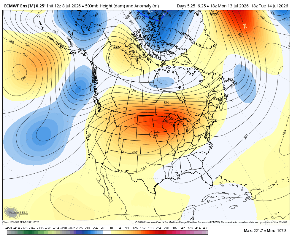
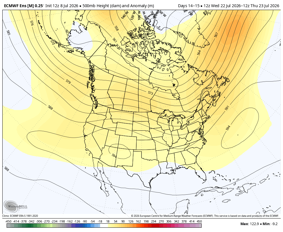
This is what the same 500 mb forecast looks like on July 23rd, 9 days later. This too has been the exact same forecast since Sunday for the end of the 2 week period, so for now it's dialed into market expectations.
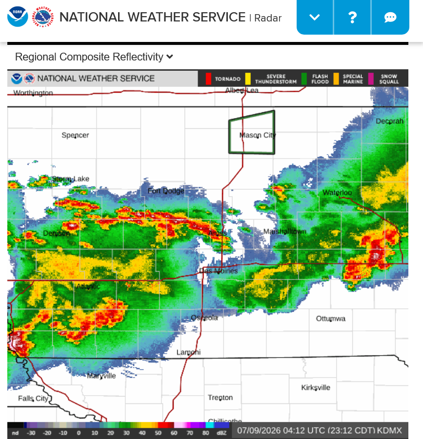
Big rains in IA tonight are helping to drop C and S even more.
There you go, tjc. Here's your chance to buy on a retrace, especially in CZ!
I honestly didn't think we would drop so much today(reverse lower) with additional losses tonight.
I'm not buying here.
+++++++
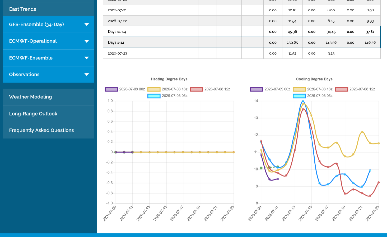
The last 18z GEFS in brown/yellow below was a whopping +16 CDDS HOTTER vs the previous 12z run for just the Midwest!! No help for the grains with this big rain falling.
Added: This model run was an OUTLIER. NOTE the other runs show temperatures massively cooling off in the Midwest! This is potentially bearish.
I will have to cover my shorts prior to getting long!
Intention is to buy on a negative report!
HUGH????
I am short grains from last night. Working.
I 'anticipate' a negative report---quick drop. If so, will cover shorts AND REVERSE tp long
HUGH X2 ?????
Yes, i do REVERSE.
If, If like many report days, grains will start lower, then gradually recover leading up to 11am. Then ???
If lower after report, I cover. Then 'watch' to get long.
Thanks, tjc!
If you are asking for my time and assistance in finding a place to buy on a retrace because you are bullish and want to be long, it's not a good idea to post that you are suddenly short from the previous day...........if you want my assistance for your last thoughts/posts that you vehemently expressed here...........being long based on your bullish analysis.
Especially the week after calling my weather forecasting pathetic but at least apologized and I accepted without taking it or anything else personal.
Just telling you this because my time is valuable and I will sincerely share it and take people at their word based on their last posts here...........until they do things that make me question that alliance.
It's perfectly fine to change your mind and trade however you want and post it or not here. Or post any thoughts about anything.
However, please don't ask for help on one thing and leaving me trying to help you on THAT thing.........when you are actually doing the exact opposite thing!
We BOTH are dealing with weather markets.
I have personally concurred that THE seasonal lows are in from (my) cycle point of view AND my perception weather is/was too wet AND now is susceptible to yield loss from potential heat/lack of rain, which has been expertly detailed by you. (Stressed 'surface' roots, nitrogen loss, etc)
HAVING MISSED the July 2 and/or Sunday night July 5 BUY, I waited, looking for a place to get long. Wednesday day, much like your comments for NG, grains did not follow through, some appeared to top. Bought SQ Friday puts and sold BOZ after golf league Wednesday night.
I will exit the short term SHORTS PRIOR to the Report.
WILL look to go long on a 'negative' report. Having MISSED last week buying, I am 'forced' to act defensively in my purchases.
I am NOT in disagreement with your articulated trading posts. You KNEW weather was going to dominate Sunday night--I did not so anticipate. You did well! I had an act of omission.
Criticize me for 'scalping', but I am ahead, will cover, and 'hope' for negative report (but wont have a trade until after the report).
As for where to buy, i might "guess" with a low price open order, watch and try to "jump" in, or might get left out.
PS I will have index puts over the weekend
Mike--I believe you and I are in harmony. Sometimes you are a VERY short term trader, and now I definitely am. At least, you and I can agree WE ARE FLEXIBLE!!
Fair enough and reasonable explanation, tjc!
July 10, 2026: 6000m Ridge | Large Model-to-Model Differences | Weak Flow (30-day Cadence???) ...
https://www.youtube.com/watch?v=PmlBuo8EiyY
+++++++++
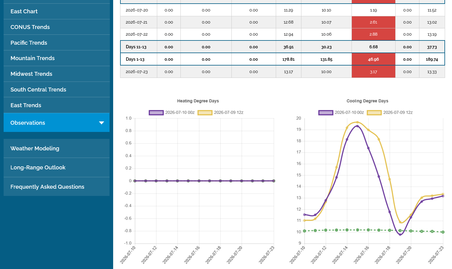
The Midwest continues to MASSIVELY COOL OFF compared to forecasts early this week.
These are CDDs on the last 0z European Ensemble model in purple that were another -12 CDDs vs the previous run.
I backed off on my bullishness on Wednesday, no longer looking to buy on any setbacks(for now) but leaning that way slightly from a neutral position since we've had the correction lower.
No way looking to do anything today with so much uncertainty, including the impact from the USDA report at 11 am that could be completely dialed in right away or could provide a fresh bullish or bearish back drop for next weeks trading.
https://www.marketforum.com/forum/topic/121389/#121435
I only trade high confidence signals based on weather pattern changes from the previous sessions that aren't always triggered every day(though that can happen). Others can trade because they need the action(like a gambler) and that's fine with me.
++++++++++++++++++++
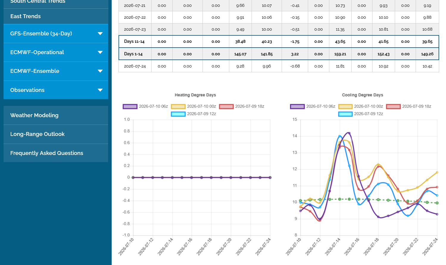
The just out 6z GEFS in purple continued this cooling trend in a big way! -16 CCDs vs the previous run for just the Midwest!!
It now has below normal temperatures for week 2!
Just returned from attending a wake. Wow, grains up. Makes me want to shift gears to selling a bullish report.
NG and BOIL give NO indication of 'troublesome' weather AND Mike's post confirms this does not appear to be a weather rally.
Will monitor going into the close.
USDA hikes 2025/26 Argentina corn production even further, to 63 mmt. That estimate has risen 11 mmt in just three months. No changes were made to any other key South American production numbers.
++++++++++
USDA cuts old-crop U.S. corn ending stocks by much more than analysts expected, while soybeans came down slightly more than expected. New-crop wheat and corn came down from last month. Soybeans were unchanged but below analyst estimates.
++++++++++++
After the June acreage survey, USDA's 2026/27 U.S. corn production estimate edges up to 16 billion bushels, more than 1 bbu smaller than last year's record crop. However, 2026/27 soybean output is seen up 5% from the prior year on larger area.
++++++++++++++++++++
·
USDA's 2026/27 world ending stock projections all came in below market expectations. A smaller U.S. crop drove wheat lower, while corn was down on a smaller carry-in. The 26/27 EU corn harvest was cut by 3.7 mmt on the French troubles. New-crop China soy imports went up 1 mmt.
The 2026 U.S. wheat harvest shrank even further this month, but the magnitude was relatively small. Total output came in only slightly above trade expectations, as a larger spring crop offset a smaller winter crop. However, wheat output in every class is down y/y.
From Karen:
Immediate report reaction: USDA made the demand changes I felt were necessary on old-crop U.S. corn, except exports could have gone up as sales exceed the target. Global stocks still look relatively comfortable, but less so than in prior months. And crops are far from settled.
There's been an incredibly bearish shift in the weather forecasts since early this week(starting Wednesday when we had the reversal down in price but picking up since then).
https://www.cpc.ncep.noaa.gov/products/predictions/WK34/
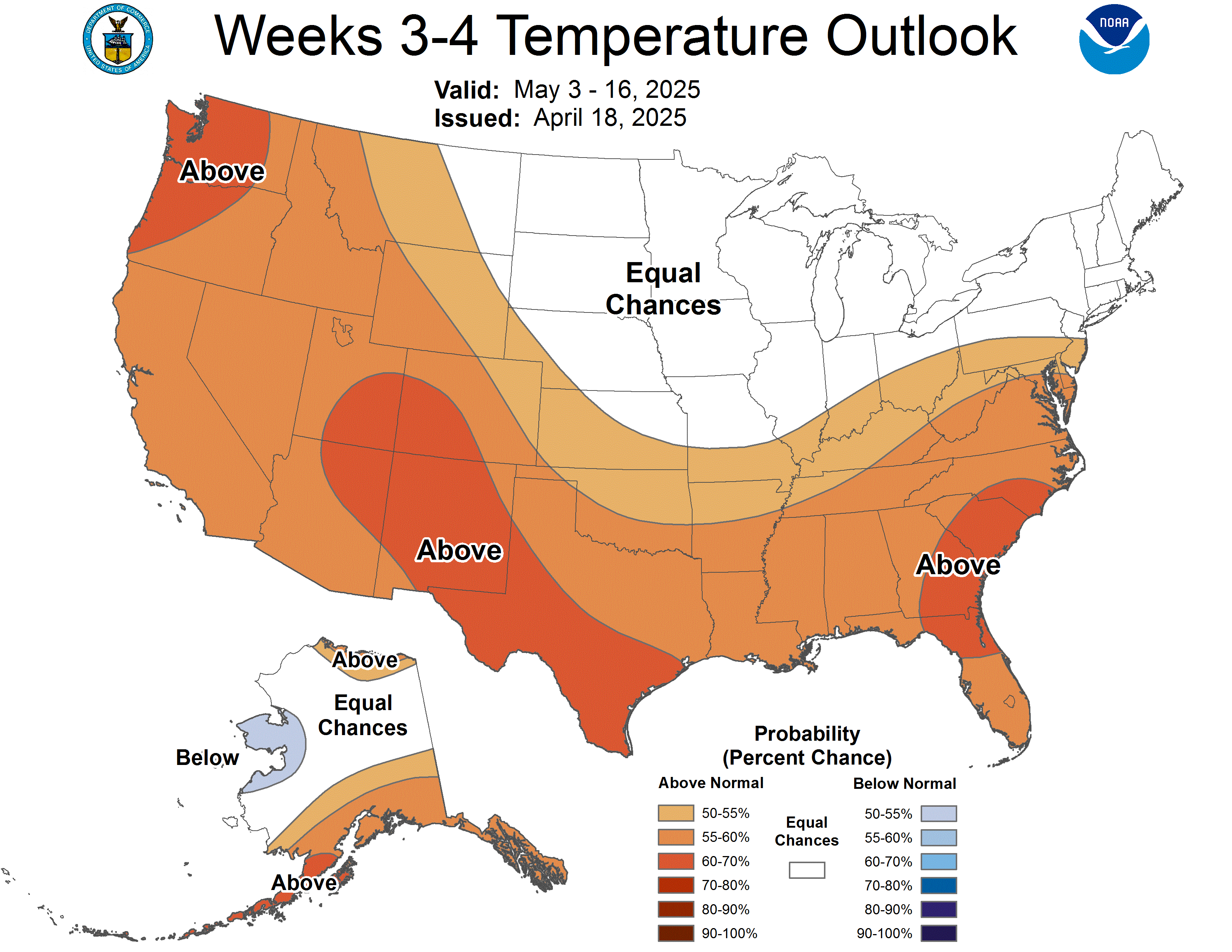
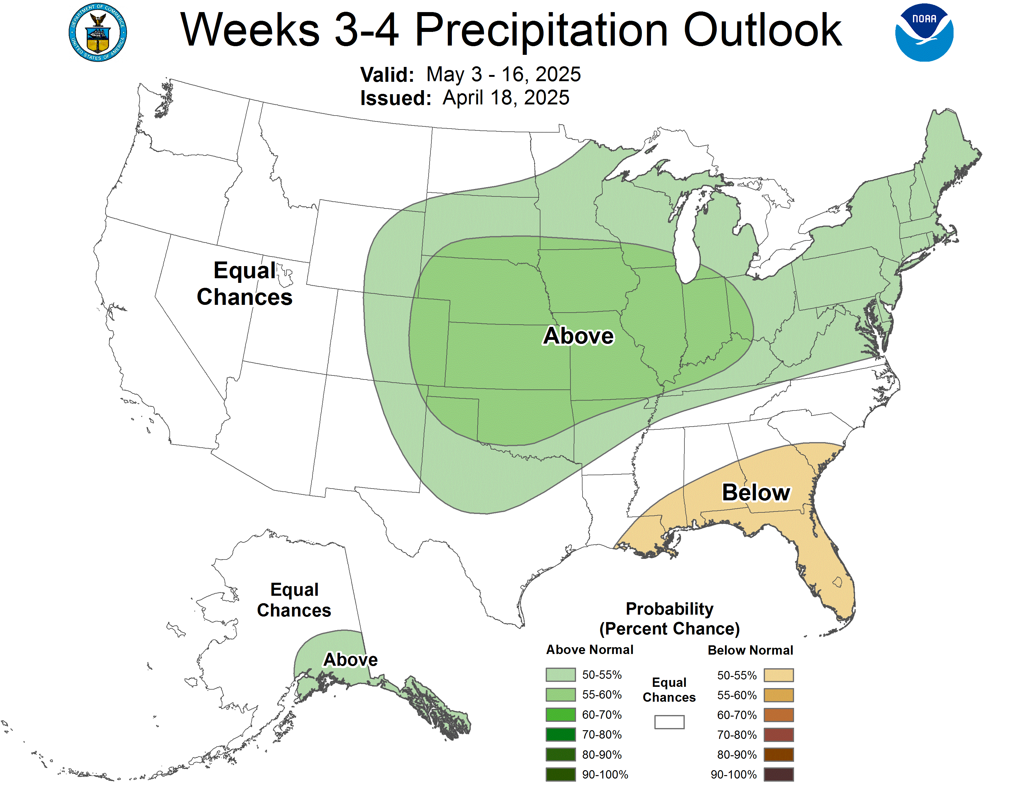
I wanted the models to go the other way, turn hotter and drier....move the dome back into the Midwest instead of backing it out southwest and allowing increasing northwest flow into the Midwest in order to buy.
But just the opposite has been happening and as noted previously, WET/MOIST SOILS in the Midwest and AN EL NINO make keeping a dome of death on top the Cornbelt, incredibly rare in July.
It's not happened during an El Nino during my trading days over 3+ decades. That doesn't mean things can't change suddenly and the weather outlook changing back to hotter and drier again.
++++++++++++
The week 2 forecast is becoming less bullish with time too but it's Friday. This all means ZERO on Sunday evening!
https://www.cpc.ncep.noaa.gov/products/predictions/814day/index.php
++++++++++
I could just as likely load the boat short on the open this Sunday if this trend continues.
With no rain anywhere the next week and the upcoming heat, I would think that we open HIGHER in an hour.
Maybe we can build on that??? It's hard to imagine the market going down when the next rain is so far off.
However, week 2 has added some rain and is cooler than week 1 but that could change at some point this week.
7 Day Total precipitation below:
http://www.wpc.ncep.noaa.govcdx /qpf/p168i.gif?1530796126
My Sunday chart, RSI, and %R review suggests, SELL strength M/Tu.
AgTalk suggests we open higher. 90 to 70 all week in N. Cen Illinois. No rain until Friday. We are moist. Tasseling will finish this week.
Market will digest this news by 9pm??
Thanks, tjc!
To make money on that position, one needed to be long over the weekend for the gap higher tonight.
Will it be an upside break away gap or will it be filled and serve as a gap and crap, buying exhaustion.
It's only been 11 minutes but decent volume so far.
The weather is mostly in the drivers seat.
HaHa!! Whose driver seat?? Frankly, isnt 90-70 'perfect' growing conditions for a crop that started out 'slow' and needs heat? (Not position talking, just most Illinois!) CUTWORM your thoughts! Somebody in IOWA
Sell sx 1212 working
WILL sell stop new low!
SHORT Into gap
"Hopefully" the gap and crap----I think so. Friday was %R sell, Monday late into alpha (high) cycle, AND last Monday spring now overdone. Good news for longs over??
(I am Excessively short)
This is a story of the haves and have nots regarding rain.
Rainfall totals for the last 24 hours to 3 days - high resolution map – iWeatherNet
Perfect temps are 86 and 65
My corn seems to be ok with the heat here. I could use some more rain. 3/4 inch yesterday first rain since 6-22. But 35 miles north had 6 inches in a short time, not good. corn is in varying stages here with some pollinated and some not even having flag leaf yet. the heat and low humidities will hurt the corn in the north, just my opinion.
Beans here look good except needing rain, some spots short.
I have no idea where the market is going.
Wonderful comments, cutworm!
The soybean market is currently in a SLIGHT backwardation condition!
The front month August is leading the bull charge and is priced slightly HIGHER than the back/deferred months, including November. That does not happen that often and it's a solid bullish indicator on demand/supply of the OLD crop.
I Overview

++++++++++
+++++++++++++
This is why the soybean market, including new crop is near the highs of the year and corn is 50c lower than the highs made in May.
That much more BULLISH technical/chart formation for beans does not necessarily make soybeans a better short here on the same weather. A person using charts and technical patterns should know this already.
+++++++++++++
This is not a prediction of where the price is going, just a key point about the current fundamental that caused the current bullish technical upward trend on the soybean charts, while the corn gave up the bull 2 months ago and has had a bearish chart formation during the exact same time frame.
The weather continues to morph a bit more bearish with each model run.
Corn and bean condition both improved 1% in the excellent category which was probably anticipated(apparently not below). That's obviously bearish in the month of July!
https://esmis.nal.usda.gov/sites/default/release-files/795977/prog2826.txt
+++++++++++
U.S. corn and soybean conditions improve 1 pt each, against the market's expectation for unchanged. One-third of the corn crop has reached the silking stage, a critical period in the reproduction cycle. One-fifth of the soybean crop is already setting pods.
++++++++++++
The weather also continues to slowly morph more bearish in week 2.
The main weather risk to the upside here is that the WCB could go into a flash drought by the end of the month.
No rain with a high angled July sun WILL dry out soils fast. Temps will be dropping, especially in the ECB after this weeks ridge backs off but the ridge axis is still not the best for rains in the WCB.
Thanks very much, cutworm.
Those links didn't work but we understand your solid point. The pipeline for C and S in the ECB is out and cash markets are putting in strong bids to pry C and S out of storage.
It's actually a wonderful thing for producers that want to clean out their bins with an unexpected bonus ahead of harvest.
Date: 7/13/2026
https://www.agweb.com/markets/cash-grain-bids
++++++++++++
I have rarely followed this metric and am NOT an authority like cutworm, so additional comments would be appreciated.
The current situation might not be that unusual. In fact, I know of a couple years when it was MUCH more extreme. Regardless, it's a bullish item underpinning the S market right now with near term demand. If the weather goes back to being near perfect, we can still go lower no matter what.
+++++++++++++
AI Overview
++++++++++++++++
This is just Indiana. NOT the case in the WCB!
https://www.hoosieragtoday.com/2026/07/09/corn-and-soybean-basis-defies-seasonal-trend/
++++++++++++++++
Basis Is Strengthening in 38 of 40 Markets—Here's Why
https://www.youtube.com/watch?v=wx6ECBN2IW0
July 13, 2026: How Long Does the Heat Last? | Tropical Development in Gulf??? | More Smoke | 100%...
https://www.youtube.com/watch?v=TbS-3F5G2go
++++++++++++
As mentioned earlier, the WCB(and N.Plains) have a risk of going over to a FLASH DROUGHT in week 2. I would expand that area farther southeast.
https://www.cpc.ncep.noaa.gov/
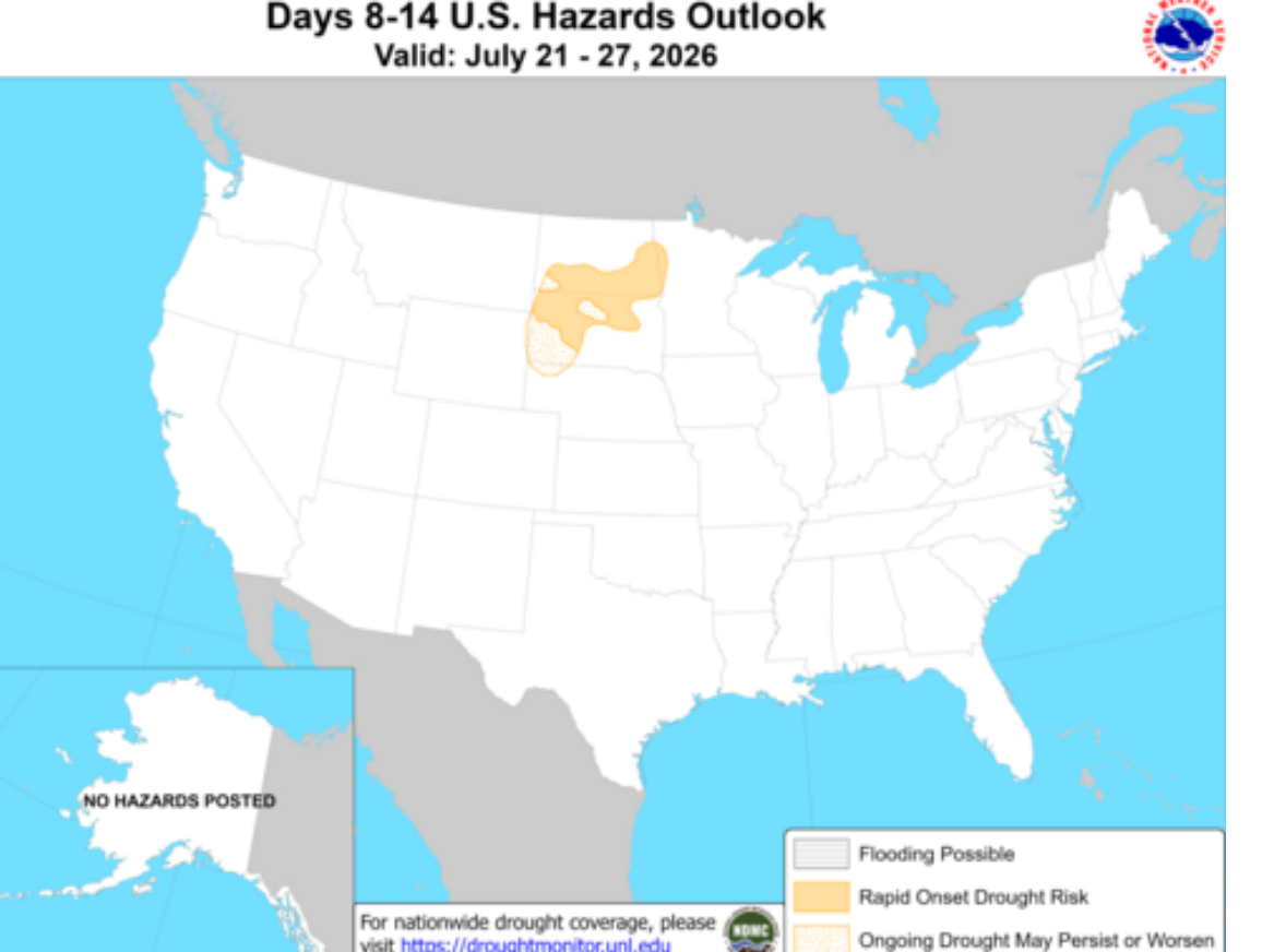
Again, the actual weather models over the last week have continued to cool this area off and have introduced CHANCES for rain but unfortunately, those are IFFY in the Plains and WCB.
The most certain part of the forecast is that there will not be much rain in week 1.
Not surprisingly, after a 1 day correction a bit lower on Tuesday, we are back above last week's highs.
The forecast has tremendous uncertainty in it. Even week 1 has great uncertainty with regards to how much rain will fall, even though temperatures will, for sure cool off late in the period which had been the main BEARISH item that was increasing in the earlier forecasts but got baked in earlier this week.
This is just the July 17-21 period below. There will be some lingering heat that dries soils out and makes rains in week 2 necessary in order to avoid any deterioration in crop ratings late this month. The hot July sun can dry things out quickly and bring on a flash drought.
https://www.wpc.ncep.noaa.gov/threats/threats.php
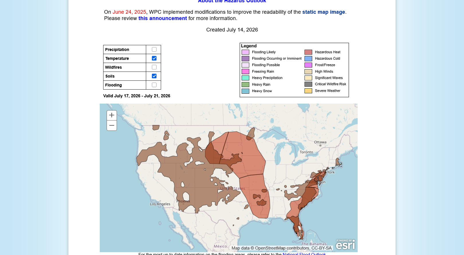
7 Day Total precipitation below:
http://www.wpc.ncep.noaa.govcdx /qpf/p168i.gif?1530796126
At the same time, there are additional changes in the models right now that may be increasing rain chances in the far WCB,in places that looked the driest in week 2(if monsoon moisture tracks far enough in that direction), while potentially reducing chances in the ECB that looked the wettest. Much uncertainty on rains.
++++++++
Wheat is taking off like a rocket here too which is likely pulling up the corn, even though the beans have the more bullish fundamentals with August beans being in backwardation, as mentioned earlier.
Maybe the historic hot/dry weather wrecking the crop in Europe is having a bullish impact this year?
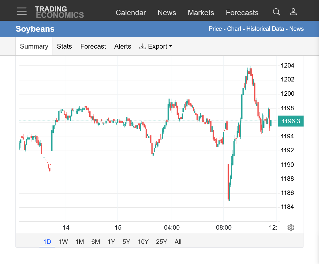
The day session open in beans at 8:30 am was pretty insane and shows the extreme uncertainty right now.
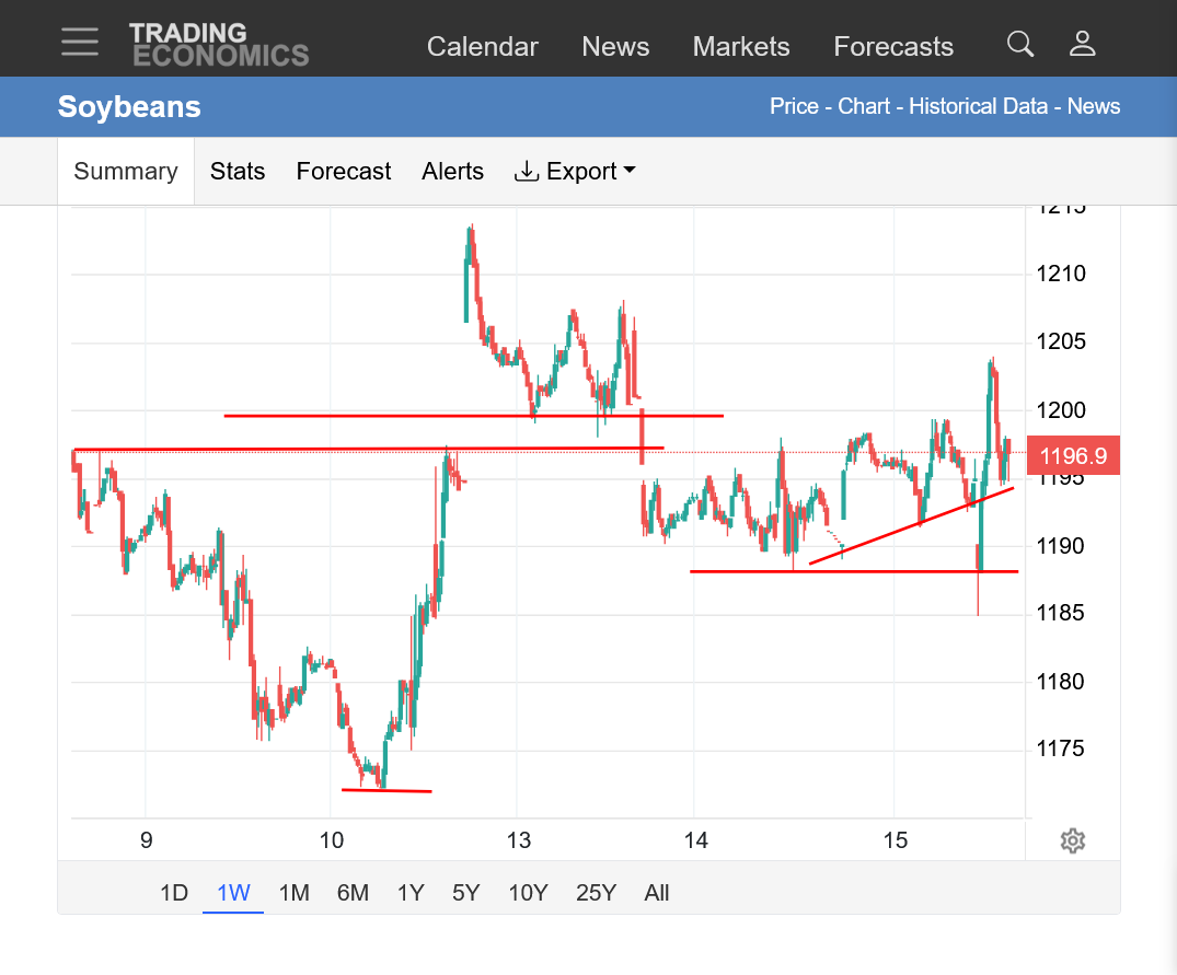
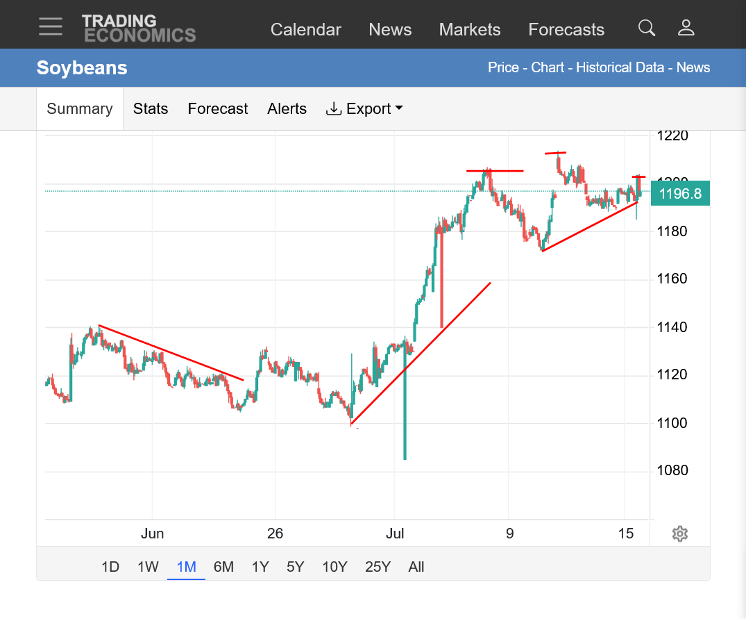
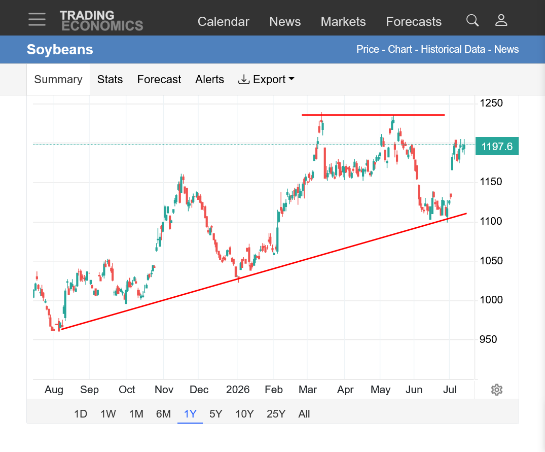
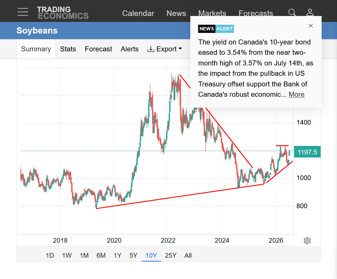
https://tradingeconomics.com/commodity/soybeans
1. 1 day: After trading strong overnight, we opened the day session lower, spiked to new lows, then quickly jumped +19c from those lows.
2. 1 week: Well above last weeks low. Gap and crap open and short term buying exhaustion Sunday Night. This weeks lows spiked thru/tested on the day session open. Bullish posture/uptrending but also potential top.
3. 1 month: Significant low. 2 uptrends, the last one is less steep. Potential top or just a bull flag?
4. 1 year: Strong uptrend still intact. Potential double top.
5. 10 years: Upside break out with steepening slope up. Current pause or short term top? Looks pretty bullish from this perspective.
+++++++++++
This is a contra seasonal move in beans! It's tough to get soybeans to go higher in July without severe weather adversity ( extreme wx adversity is something that we are NOT seeing right now).
We appear to have put in our seasonal, late Spring top early this year(May) and put in our seasonal Summer low-often around the first week in August, early too.
Each year is different!
https://charts.equityclock.com/soybeans-futures-s-seasonal-chart

Corn has suddenly come alive, probably with big help from wheat prices blasting off.
As mentioned previously, the hot/dry weather in Europe may have wrecked their crop and provided a huge supply driven (losses from global supply because of weather) boost.
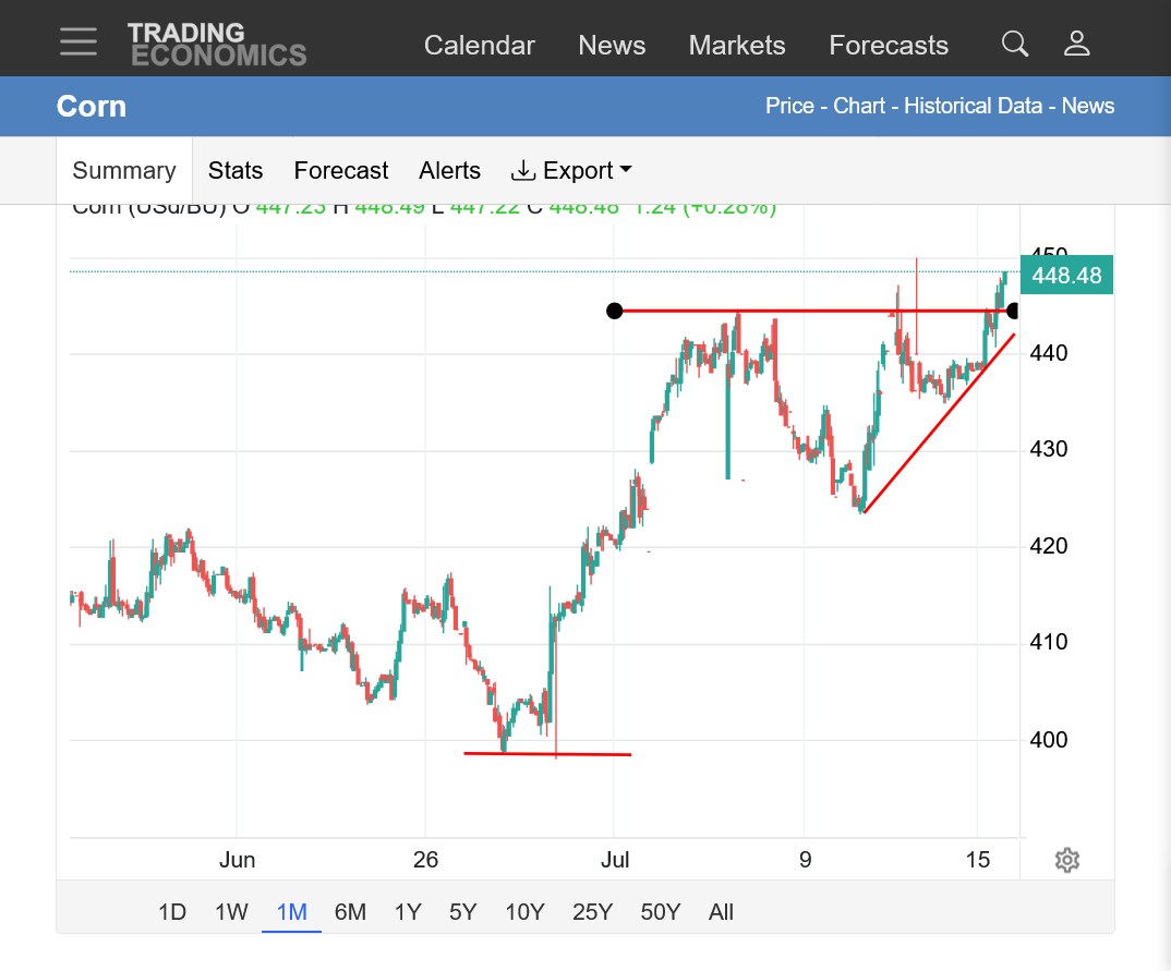
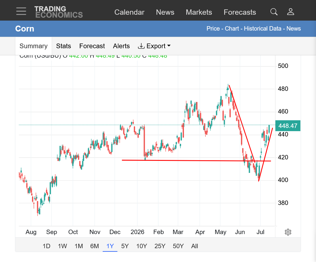
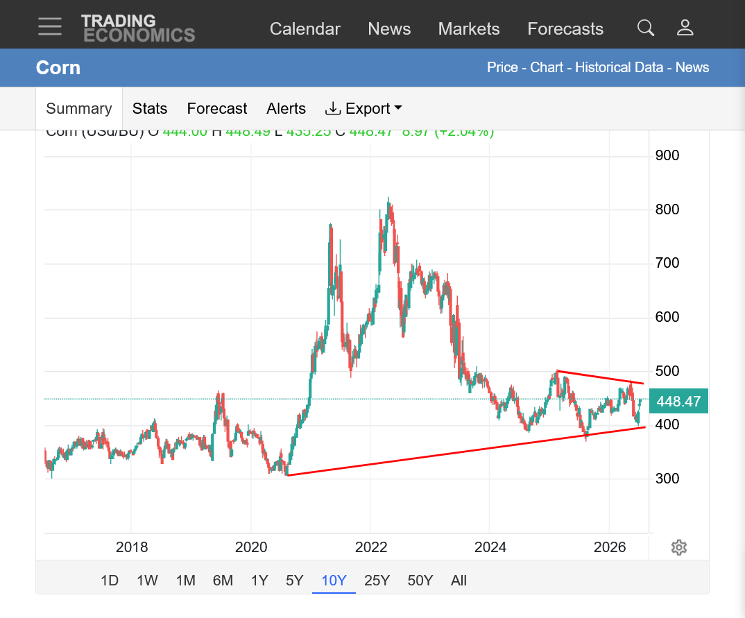
https://tradingeconomics.com/commodity/corn
1. 1 month: Breaking out to the upside?
2. 1 year: Seasonal top early in May on bearish weather. Unusually early Summer spike low with steep uptrend. Now above the previous low. Very bullish posturing. Potential resistance here.
3. Symmetrical triangle with lower highs and higher lows.
+++++++
Like with beans, corn had an early top on bearish weather in May. Now, a very contra seasonal move up in July and without extreme weather adversity.
https://charts.equityclock.com/corn-futures-c-seasonal-chart

Let me emphasize one point on the market's move higher without extreme weather adversity.........yet.
As always, these are FUTURES markets. As mentioned on this upper level ridge axis ahead. Although it will back off and allow cooler temps, which is pretty bearish, the position is UNFAVORABLE for widespread rains especially in the WCB into the CCB.
The full July sun and no rain can bring on flash drought faster than most people anticipate. Even though that could be 2 weeks out and not impact crop ratings until AFTER that, the market has been known to trade that in the past as a FUTURES market.
And what often matters is the CHANGE compared to the previous weather pattern. When temperatures cooled off in the forecast, it was BEARISH compared to the expected heat.
However, rain amounts in the current forecast are not nearly as bountiful as what our crops were treated to thru most of the Summer until this week. Drier or drying in a July weather forecast is a bullish element.
A pattern change back to wetter would likely take us on a trip lower but it seems like the lows are in with moderate/high confidence.
NOPA U.S. crush, June 2026:214.34 mln bushels of soybeansbove all trade estimates (avg ~204 mbu)+16% from June 2025Soyoil stocks 1.501 bln lbsBelow all trade estimates (avg 1.65 bln)Soyoil stocks at 8-month low
Also, along with weather, the black sea developments are having an effect especially in wheat and corn. Russia is the biggest exporter of Wheat and Ukraine is 4th or 5th. How will this end???
Eric had our weather on Wednesday morning:
Hello Eric Snodgrass and thanks for the weather this morning!
This has been an unusual July for weather. The intense heat and dry weather in the northwest Cornbelt, as expected has contributed to flash drought type soil moisture levels there.
https://www.cpc.ncep.noaa.gov/products/Soilmst_Monitoring/US/Soilmst/Soilmst.shtml#
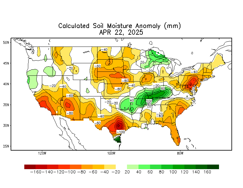
Overall, soil moisture will continue to drop the next 2 weeks(not unusual for this time of year when evaporation rates typically exceed rainfall) but not everywhere with some rains and a big temporary cool off later this week. Then week 2 heat comes roaring back, especially in the WCB. Rains in week 2 are a huge ????
With the heat in week 2, even places that get lucky enough to see normal amounts of rain will see shrinking soil moisture.
7 Day Total precipitation below:
http://www.wpc.ncep.noaa.govcdx /qpf/p168i.gif?1530796126
The El Nino impact is uncertain. Typically El Nino contributes to favorable weather in the Cornbelt but each year is different because the rest of the Pacific Ocean, north of the El Nino is fighting that. The teleconnection from the Atlantic Ocean can be a huge factor.
Both Corn and Beans gapped higher on the open.
Corn on the daily. Beans on the weekly and monthly also.
++++++++++
Just like last Sunday, the grains/beans gapped higher on the open but there was no follow thru. We're on the lows right now but haven't filled the gaps yet in C and S. However, wheat did fill its gap higher and is almost back to unch. Volume is pretty decent for just 3 hours of trading so far.
As mentioned earlier, the weather is not completely 1 sided.
nov. beans appear to break out of cup and handle formation, if so target is 12.90 to 13.00
Thanks, knox!
Beans and corn never could fill the gap higher so now it's a very bullish upside break away gap and its from the weather.
We took out rain in both weeks 1 and 2 overnight. Rain was already questionable for week 2, now there's not much question about it............there won't be very much in most of the Cornbelt in week 2 .
We've been getting by pretty good here in southwest IN, while missing the nice rains the past week+ but it looks like we could go completely dry the next 2 weeks+ with rains to our east and southwest this week and turning dry everywhere in week 2.
Maybe that will change.
A large portion of the U.S. corn crop moved through pollination during last week's heat wave, though ratings fell only 1 pt versus the expected 2-pt decline. Soybean conditions rose 1 pt against an expected 1-pt decline, but spring wheat ratings landed below all estimates.
++++++++++++++++
The intense heat wave was in the epi-center of Spring Wheat country so it makes sense for conditions to drop 5%. But this was dialed in last week (and earlier this month) with the huge spike up. Wheat was modestly down today.
Soybeans benefited overall from last week weather. (lots of bean in the south). Pollinating corn in the extreme heat probably got hurt some.
++++++++++++++
The market will trade this briefly and go back to weather. As mentioned earlier, MOST OF THE RAIN HAS BEEN TAKEN OUT, along with heat roaring back in week 2.
https://www.marketforum.com/forum/topic/83844/#83852
++++++++++++
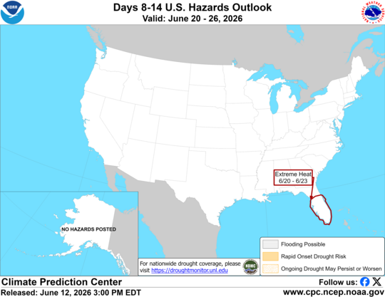
https://www.cpc.ncep.noaa.gov/
good eyes Knox
Agree, cutworm(and knox)!
Hopefully tjc didn't lose too much money on his short position.
Crop ratings right now are actually pretty good for this time of year and the center of the dome will never return to the Cornbelt like it did last week.
However, the strong ridge extending from the dome will extend well north to the Canadian border and be in a horrible place for rain chances in the Cornbelt. Even with northwest flow at times east of the ridge, the flow will lack perturbations and moisture return to be effective rain makers.
The trough to the east of the Midwest is in exactly the worst position for rains in the Cornbelt.
You don't get much rain WEST of troughs in unproductive northwest flow!
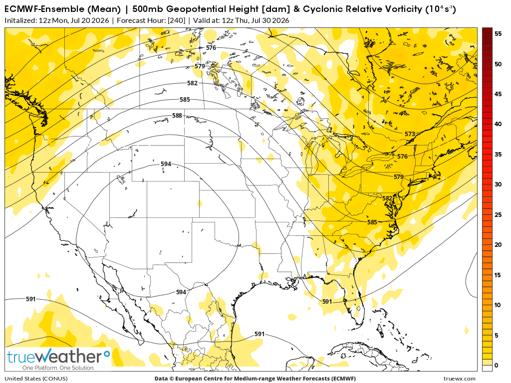
This was the day 10 map from the last 12z European Ensemble model with the vorticity/spin in the atmosphere.
There is basically NO HOPE for any rain from IL westward, along with some intense heat coming off the dome to the west.
Even in the far ECB, we will need a lot of luck to get 1 rain in a WEEK 2 pattern like this. Strangely, there could be monsoonal flow around the periphery of the dome that comes into the C.Plains/WCB but that's a big wildcard and not the forecast.
August is the key weather month for beans. Should this define the pattern for August, I wouldn't put an upside target on November beans.

+++++++++++++
We should also add the fact that the heat wave in the central and eastern Cornbelt early this month, mostly stayed at 95 deg. F and below because of moist soils, despite an impressive heat dome aloft.
Right now is the climatological peak in average temperatures historically. However, with soils definitely drying out the next 2 weeks, we will be very primed for temperatures to get even hotter in late July and August, even though the sun angle and day length peaked on June 21st and climatology peaked this week.
Every year is different. This year, at least the way its looking now could be headed towards flash drought in a big area of the Cornbelt in early August.
++++++++++
6:20pm: And then we can get into the drought begets drought vicious positive feedback cycle at this time of year which can only be broken by a significant pattern change:
More about that here:
Re: : 6-25-26 MAJOR heat wave coming next week
By metmike - June 27, 2026, 9:58 a.m.
+++++++++++++
Eric's weather this morning:
July 20, 2026: Tropical Storm Bertha? | Pac NW Fires | Severe Storms Midwest to the East Coast...
Not to worry, TJC went home flat Friday, then bought open Sunday night. Covered beans for profit, covered oats wayyyy before they fell, still long b oil and rice Will buy beans and wheat dime lower.
Thanks, tjc!
You forgot to tell us about your bean shorts last week.
We have a shot for rain the next 7 hours here in southwest, IN until this cold front goes thru late afternoon. Some extremely steamy dew points ahead of the front in this air mass, a few at 80+ are pretty impressive just after 10am.
That's the feature causing the Heat Index to soar higher today. The next 3 frames are frozen images.
1. Air temp-10am Central
2. Heat Index-20 deg, higher in spots from humidity
3. Dew Point-75 Deg+ in most places ahead of front
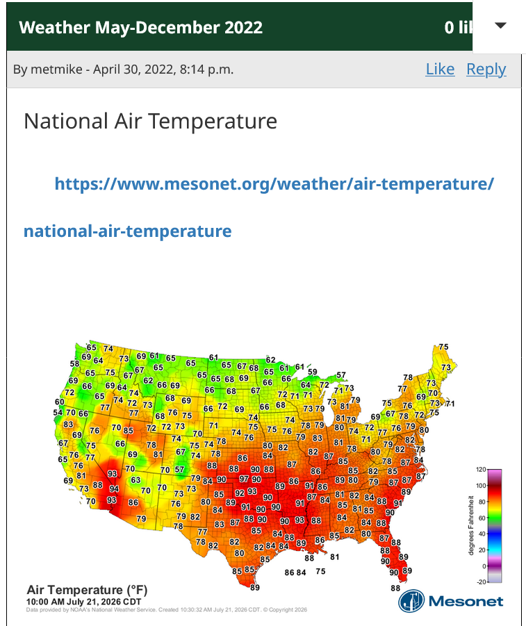
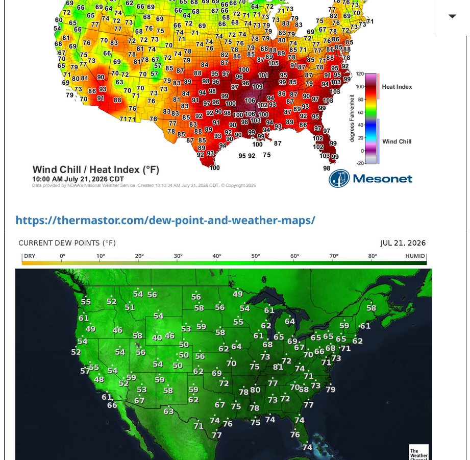
+++++++++++=
Constant updates below:
https://www.marketforum.com/forum/topic/83844/#83845
https://thermastor.com/dew-point-and-weather-maps/
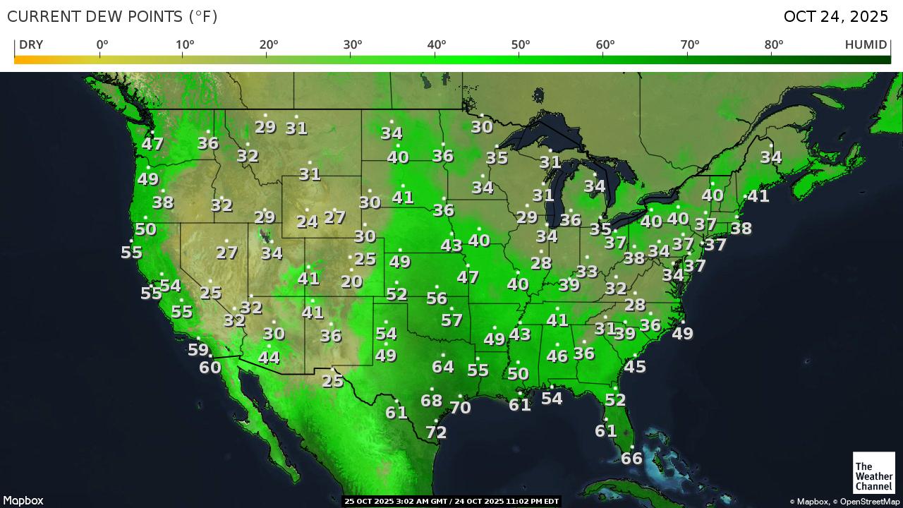
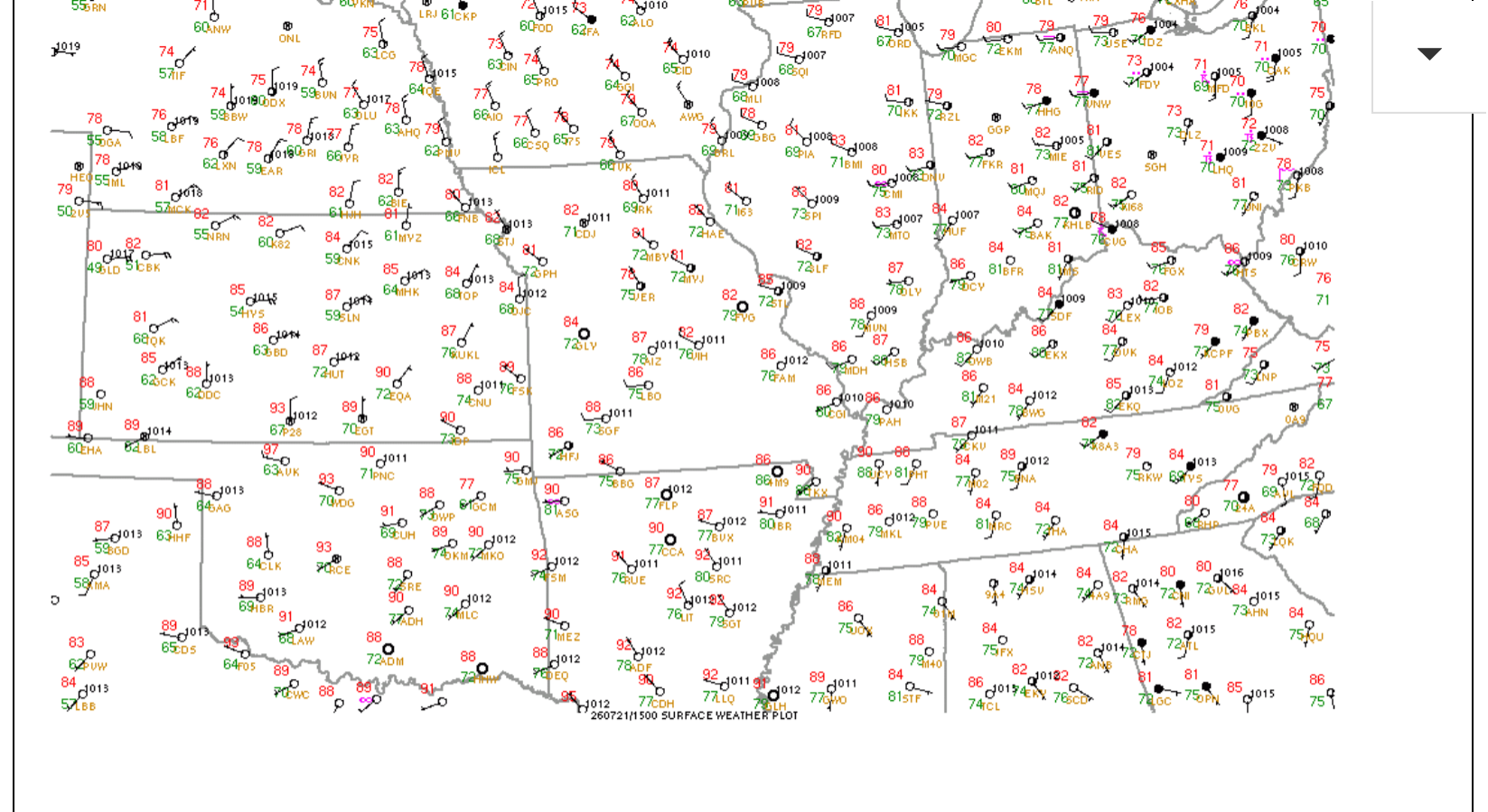
We missed the rains here in southwest, IN. No surprise. Our 80 deg. dew point yesterday was only 1 deg. from the highest DP ever recorded in Evansville. 81 deg. dew point happened on 4 previous occasions.
It's one thing when EVERYBODY misses rains around you. That stinks. But when this much rain falls this close to you and all around you, while you get ZILCH, it really bites!
https://www.raindrop.farm/rainfall-totals/zipcode/47725#map
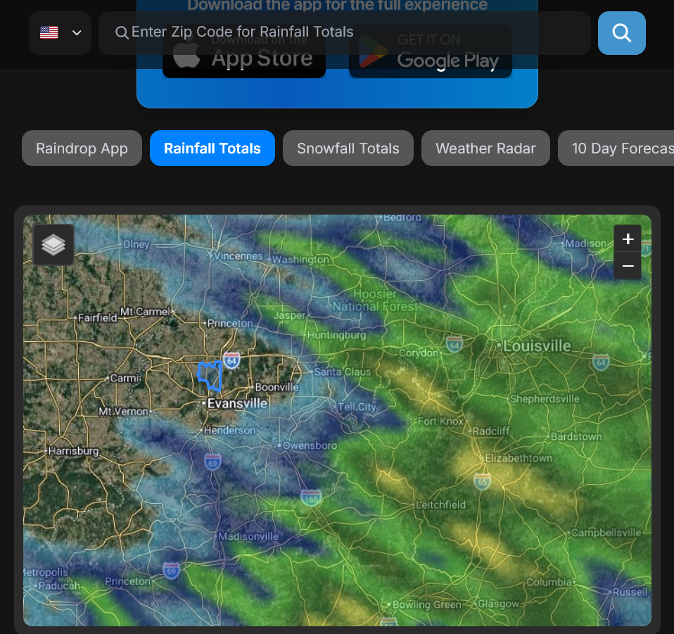
Next rain chance? Who knows!
The small correction lower ended this morning after midnight. Again, great call knox!
Brain Split discusses the charts. starts 5:34
Thanks, cutworm!
Do you have a link, please?
The models are turning MUCH LESS BULLISH in week 2.
If this continues, by Sunday Night it could be pretty bearish.
This was the last run of the 0z Canadian model ensemble run. Note the individual solutions below the average/mean if you go to the link.
The wide range is massive with 3 different main camps of solutions.
1 camp in extremely bullish. The slight plurality camp is extremely bearish. When you average them together, we get the map below.
But here's the thing. The map below is NOT a solution that represents most of the solutions. It's the solution of the 2 extremes and 1 in the middle averaged out.
In reality, 1 camp is likely to be much more right and the other ones wrong as opposed to the average below happening.
The solution below looks more like the bearish camp, so that gets my nod and the solutions for the past 3-5 runs have been more bearish for this model.
The other thing, the Canadian ensemble is by far the most bearish, even though the other models in week 2 are taking this direction.
The last 0z GEF that came out 6 hours ago added a bunch of week 2 rain, especially in the ECB. The 6 solution coming out right now might not be as wet and the European model overnight was a bit wetter than its previous run but still on the dry side.
These changes are all happening for the week 2 part of the forecast.
https://weather.gc.ca/ensemble/charts_e.html?Hour=384&Day=0&RunTime=00&Type=gz
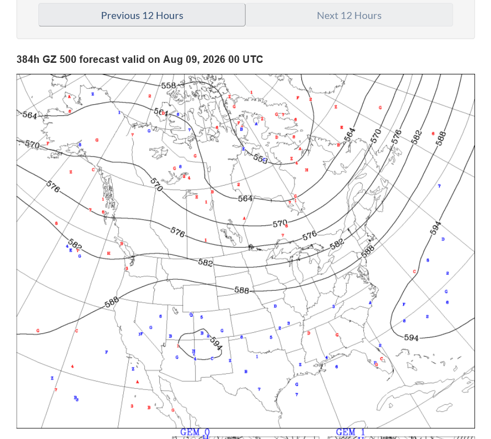
9am: Go Eric!
Sept wheat just retraced .38. Worth a try on long side.
Thank, tjc,
Actually, wheat had already bounced +10c BEFORE you made that post!
It continued up another +10c.
(It takes a minute or so to observe, then post)
tjc,
Yes, that's exactly my point!!!


