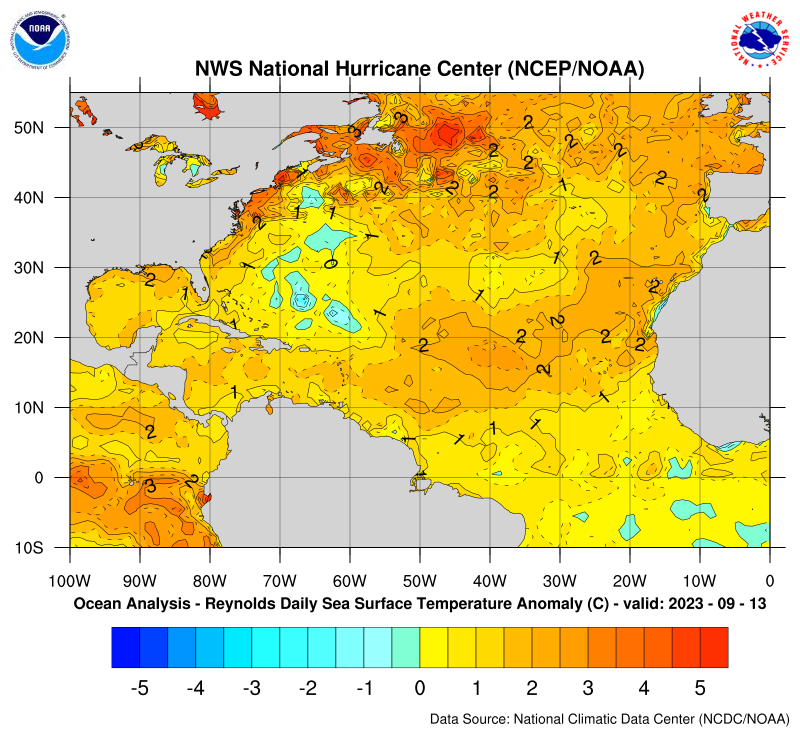
The SSTa image below from Sep 13th shows that significant cooling of the upper ocean resulting from slow moving large and major H Lee stirring up the waters started well before center passage. Note that at 11AM EDT on Sep 13th Lee was still down at 26.4N, 67.2W, despite a new blue area that stretches as far NW as 29N, 69W, that was yellow the prior day. So, the SST had already cooled ~1F all the way up at 29N, 69W, vs 24 hours earlier even though the center was still over 200 miles to the SE at the end of that 24 hours. The center didn’t even get near 29N, 69W, for another ~18 hours, during which that area and nearby cooled more. During the analyzed period, Lee was moving under 10 mph and getting larger. I was educatedly guessing (at least at AmericanWx) that Lee’s slow movement combined with large size was helping to keep its strength in check by causing significant SST cooling well ahead of the center (I assume that a little cooling well ahead of a center would be normal but this appears to have been more than average cooling due to a combo of slow movement and large size):

Thanks Larry,
This area already had been cooled by Franklin and Idalia.
I honestly don't see much additional cooling from Lee looking at the bottom 2 maps of before(9-7) and after (9-17).
Maybe I'm missing something?
https://www.marketforum.com/forum/topic/98675/#98813
Your last map from above:
++++++++++++++++++
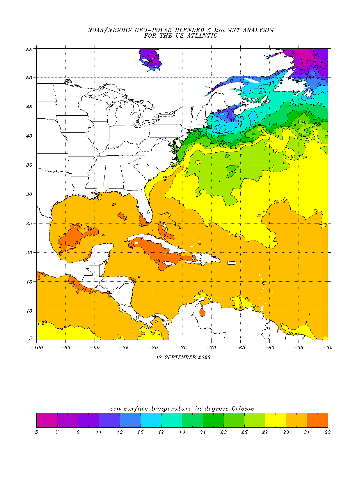
Note on these 2 maps below that the color coding on September 17th was shifted 1 deg. C to the cooler side.
What that means is this:
On Sept 17th all the same colors represent -1 Deg C compared to those same colors on September 7th.
On 9-7, the bright yellow isotherm= 28 Deg. C
On 9-17, the same bright yellow isotherm =27 Deg. C
This was done because the Atlantic Ocean basin is cooling.
+++++++++++++++++++
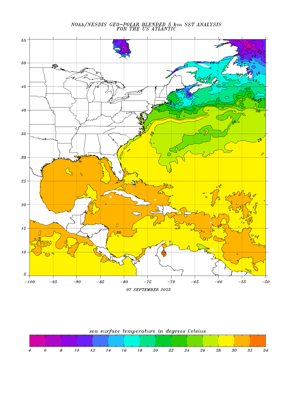
SSTs BEFORE Lee on September 7
US Atlantic. Note the cooler water left behind by Franklin and help from Idalia.
https://www.ospo.noaa.gov/data/sst/contour/usatlant.fc.gif
SSTs AFTER Lee on September 17. Pretty similar temperature configuration to me.
What do you think, Larry?
Hey Mike,
Very nice post! However, I’ll now go into more detail and show three days of maps from the same series to try to convince you:
Here are the two maps next to each other, 9/12 and 9/13. Focus on 29N, 69W. In the 9/12 map, that area is well within the first yellow and nearly up to the second yellow based on the nearby dot, meaning probably ~+0.4C:

Now look at the 9/13 map, for which there’s now the first shade of green. I’m calling that ~-0.1C:
So, I’m estimating that 29N, 69W warmed 0.5C /0.9F, or ~1F and this is still 18 hours prior to center passage.
Now I’ll show the 9/14 map, which coincides with when the center was nearest 29N, 69W:

The area near 29N, 69W, cooled a little more. But also note the full square bounded by 20-30N and 60-70W. Two days prior it averaged ~+0.5C with merely one speck of green. But on 9/14, over half is covered by green and blue with an avg of ~-.25C. So that large area cooled on average ~0.75C or ~1.35F.
Looking even more closely, note the small area near 25.5N, 67W. On 9/12, it’s well within the first yellow area or ~+0.3C. On 9/14, it is down to the 5th area or just below -2C! So, that small area cooled ~2.3C or ~4F! Why did it cool so much? The eye crossed ~right over that point ~2AM on 9/13 as a cat 3 moving only 7 mph with hurricane/TS force winds a whopping 125/240 miles from the center:
https://www.nhc.noaa.gov/archive/2023/al13/al132023.public_a.031.shtml?
Thanks much, Larry.
Yes, we can clearly see the ADDITIONAL cooling that Lee had on the area that had already cooled from the previous hurricanes using those last 3 maps, especially the last one on 9-14-23.
Great post and discussion!
Of course, Idalia DID hit the Southeast US, making landfall in a low population area (luckily) but its fortunate too, that this discussion is focused on an area in the W.Atlantic impacted by 3 hurricanes and NOT being an area 1,000 miles farther west over land/the East Coast.
https://www.marketforum.com/forum/topic/99082/
Look closely on the global map below. Notice the cool anomaly off the Mid-Atlantic/Southeast coast. That came from 3 hurricanes churning up cooler water from below up to the surface.
1. Franklin
2. Idalia
3. Lee
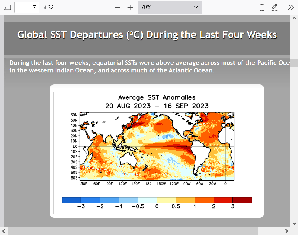
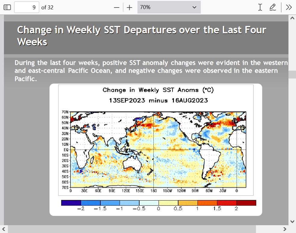
The change in temperatures during the last month below REALLY shows the cooling off the coast of the Mid-Atlantic/Southeast from the wake of those 3 hurricanes.
One job of a hurricane is to dissipate & redistribute heat. As storms move they churn up the ocean, use/ transport energy, drop heavy-cool rain & upwell cool water from down below. Summer steering took Major Hurricane’s Franklin and Lee over the same region cooling record… 1/
https://twitter.com/i/status/1703954234167697898
+++++++++++++
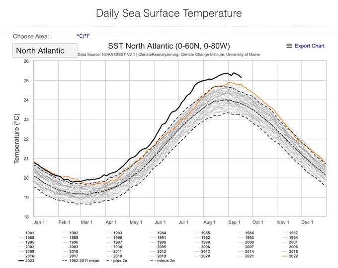
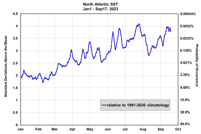
…cooling record hot sea sfc temps. Amazingly, even this large region of cooler water, and active hurricane season, has not been able to change the margin of the record hot anomalies. We are still at 4 standard deviations above normal. Nature’s typical remedies are struggling…2/
++++++++++++
Brian McNoldy
@BMcNoldy
Even with the notable cold wakes left behind by hurricanes Franklin, Lee, and Margot, the North Atlantic sea surface temperature is very far above normal... the anomalies have been hovering near +4 standard deviations during the past week, the highest since late July.
++++++
·
June 2023:
Kris Karnauskas@OceansClimateCU
Hurricanes Franklin and Lee have really cooled down the NW Atlantic for the moment. #hurricaneseason2023