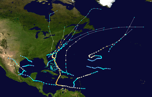
The TW now (9/1) just off African coast, which the NHC has in orange for potential development, is developed by just about all major models at 12Z. The Euro op/ens is very strong with this. I count near 60% of the 51 ens members with a H, some of which are extremely strong. Most of these get to the area between Bermuda and the Caribbean at 240 with movement between WNW and N. A few actually cross into the NE Caribbean.
At the very least this looks likely to be a big ACE producer providing pretty satellite pics. At the worst, it could greatly impact land (Caribbean, Bermuda, Bahamas, US, Canada among other places). If that were to occur, that wouldn't likely be til Sep 8-16. Potential markets affected include CT, OJ, NG, CO, and KC among others.
Tropical Weather Outlook
NWS National Hurricane Center Miami FL
200 PM EDT Fri Sep 1 2023

For the North Atlantic...Caribbean Sea and the Gulf of Mexico:
1. Eastern and Central Tropical Atlantic:
A tropical wave is expected to move off the west coast of Africa
during the next day or so. Environmental conditions appear conducive
for some gradual development of this system during the early and
middle parts of next week, and a tropical depression could form
while it moves westward to west-northwestward over the eastern and
central portions of the tropical Atlantic.
* Formation chance through 48 hours...low...near 0 percent.
* Formation chance through 7 days...medium...50 percent.
Thanks very much, Larry,
In Detroit with my almost 98year old dad The last few days.
Going to the Big House for the Michigan opening game with my Evansville family tomorrow, then home late Sunday.
As usual, you’re often the first one to alert us about upcoming tropical events.
Plenty of action in the Atlantic basin right now!
https://www.nhc.noaa.gov/gtwo.php?basin=atlc&fdays=2

Thanks, Mike.
1) This is on the verge of being declared a TD.
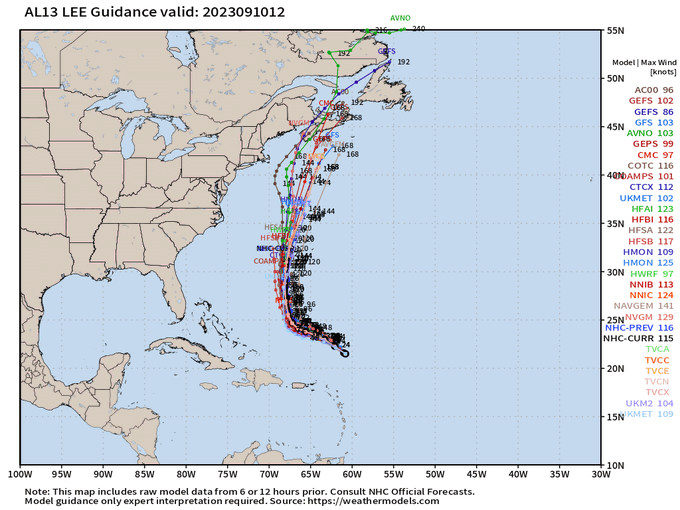
2) The model consensus is currently suggesting a pretty low threat to the CONUS and with that mainly in the NE. There is a little bit higher threat to the Bahamas and the NE Caribbean and perhaps even a bit higher than that to Nova Scotia.
3) The threat to Bermuda and vicinity appears to be about the highest as of now as a good number of ensemble members hit or get close.
4) The models are suggesting a good shot at this being the strongest storm of the season as it crosses very warm SSTs. This will likely lead to a lot of ACE. However, if it were to travel within the wake of MH Franklin within the 65-70W corridor SW and W of Bermuda, it may actually weaken some, which in theory could lessen the blow to Bermuda a bit if it were to get near there.
5) At this point, I don't see a lot of influence of this storm on any particular commodity price. But that could change if the actual track were to deviate substantially from what's expected.
Great report, Larry!
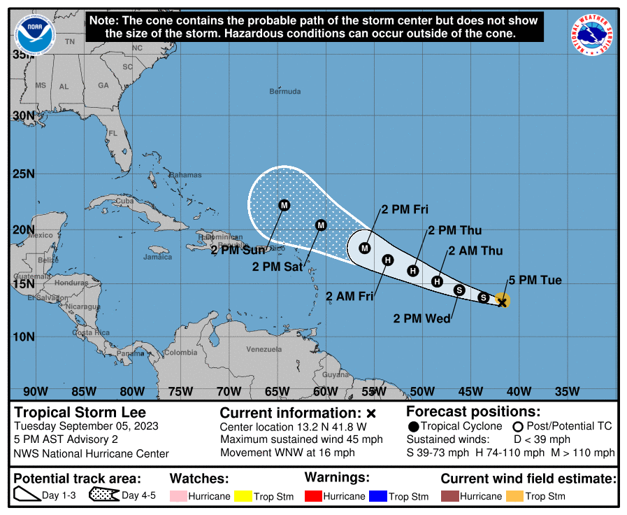
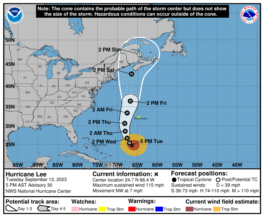
At 11AM today (Sep 5th), what was Invest 95L was upgraded to TD13:
| ...NEW TROPICAL DEPRESSION FORMS IN THE CENTRAL TROPICAL ATLANTIC... ...FORECAST TO BECOME A POWERFUL HURRICANE BY THE END OF THE WEEK... | |||||||
| 11:00 AM AST Tue Sep | |||||||
BULLETIN
Tropical Depression Thirteen Advisory Number   1
NWS National Hurricane Center Miami FL       AL132023
1100 AM AST Tue Sep 05 2023

...NEW TROPICAL DEPRESSION FORMS IN THE CENTRAL TROPICAL ATLANTIC...
...FORECAST TO BECOME A POWERFUL HURRICANE BY THE END OF THE WEEK...


SUMMARY OF 1100 AM AST...1500 UTC...INFORMATION
-----------------------------------------------
LOCATION...12.5N 40.2W
ABOUT 1425 MI...2295 KM E OF THE LESSER ANTILLES
MAXIMUM SUSTAINED WINDS...35 MPH...55 KM/H
PRESENT MOVEMENT...WNW OR 285 DEGREES AT 15 MPH...24 KM/H
MINIMUM CENTRAL PRESSURE...1008 MB...29.77 INCHES


WATCHES AND WARNINGS
--------------------
None.

Interests in the Leeward Islands should monitor the progress of
this system.


DISCUSSION AND OUTLOOK
----------------------
At 1100 AM AST (1500 UTC), the center of Tropical Depression
Thirteen was located near latitude 12.5 North, longitude 40.2 West.
The depression is moving toward the west-northwest near 15 mph (24
km/h), and this motion is expected to continue for the next few
days.

Maximum sustained winds are near 35 mph (55 km/h) with higher gusts.
The depression is forecast to be a hurricane in a couple of days
and could become a major hurricane in a few days.

The estimated minimum central pressure is 1008 mb (29.77 inches).
Tropical Depression Thirteen Discussion Number   1
NWS National Hurricane Center Miami FL       AL132023
1100 AM AST Tue Sep 05 2023

Satellite images indicate that the tropical wave (Invest AL95) that
we have been following for several days has become better organized
this morning, with many curved low-level banding features.  A
partial scatterometer pass near 1201 UTC indicated a well-defined
center had formed, with winds speeds of about 30 kt.  Thus,
advisories have been initiated on Tropical Depression Thirteen, and
the current intensity is set to 30 kt.

The depression is moving west-northwestward at about 13 kt.  A
mid-level ridge over the central Atlantic is expected to persist to
the north of the tropical cyclone, keeping the system moving with
this general motion through Saturday.  The spread in the model
guidance is remarkably low for a first advisory, and the official
forecast is near or west of the model consensus.  However, it
should be noted that the NOAA corrected-consensus aids and some
ensemble members are still to the left of the official forecast, so
it is too early to determine exactly how close this system will get
to the Leeward Islands given the average track forecast error at
those time ranges.

The environment around the depression appears to be conducive for
strengthening.  The only obvious hindering factor is
light-to-moderate northeasterly shear, which should keep the
intensification rate in check in the short term.  However, in two to
three days, this shear is forecast to relax with an upper-level
ridge building near the cyclone, and the system should be moving
over record-warm waters of near 30 deg C east of the Lesser Antilles
(that would look more in place in the Gulf of Mexico).  These
factors could support rapid intensification by the end of the week,
although it too early to determine exactly when this might occur
until a better-defined inner core forms.  The NHC intensity forecast
is extremely bullish for a first forecast, but remarkably lies
below the intensity consensus.  All indications are that the
depression will become a strong hurricane by the end of the forecast
period.

KEY MESSAGES:

1. The depression is forecast to become a major hurricane by
this weekend and could bring impacts to the Leeward Islands by that
time. While it is too soon to determine the location and magnitude
of these possible impacts, interests in this area should monitor
the progress of the depression and updates to the forecast.

FORECAST POSITIONS AND MAX WINDS

INIT  05/1500Z 12.5N  40.2W   30 KT  35 MPH
 12H  06/0000Z 12.8N  42.1W   40 KT  45 MPH
 24H  06/1200Z 13.6N  44.7W   50 KT  60 MPH
 36H  07/0000Z 14.4N  47.2W   60 KT  70 MPH
 48H  07/1200Z 15.3N  49.7W   70 KT  80 MPH
 60H  08/0000Z 16.2N  52.2W   80 KT  90 MPH
 72H  08/1200Z 17.3N  54.7W   95 KT 110 MPH
 96H  09/1200Z 19.4N  59.1W  115 KT 130 MPH
120H  10/1200Z 21.5N  63.5W  120 KT 140 MPH

$$
Forecaster Blake
Thanks, Larry!
It really is amazing that our technology has developed to the point of being able to predict major hurricanes with some skill so far in advance!
As you expected, this system just acquired a name, Tropical Storm Lee! At least the spelling an enunciation won't be a problem (-:
Fortunately, it's not a threat to the US (with a deep trough in the Eastern US next week, deflecting it AWAY for the US) even though it will strengthen into a MAJOR hurricane by late this week.
https://www.nhc.noaa.gov/graphics_at3.shtml?start#contents
https://www.nhc.noaa.gov/text/refresh/MIATCDAT3+shtml/052054.shtml?
https://www.nhc.noaa.gov/refresh/graphics_at3+shtml/205237.shtml?cone#contents
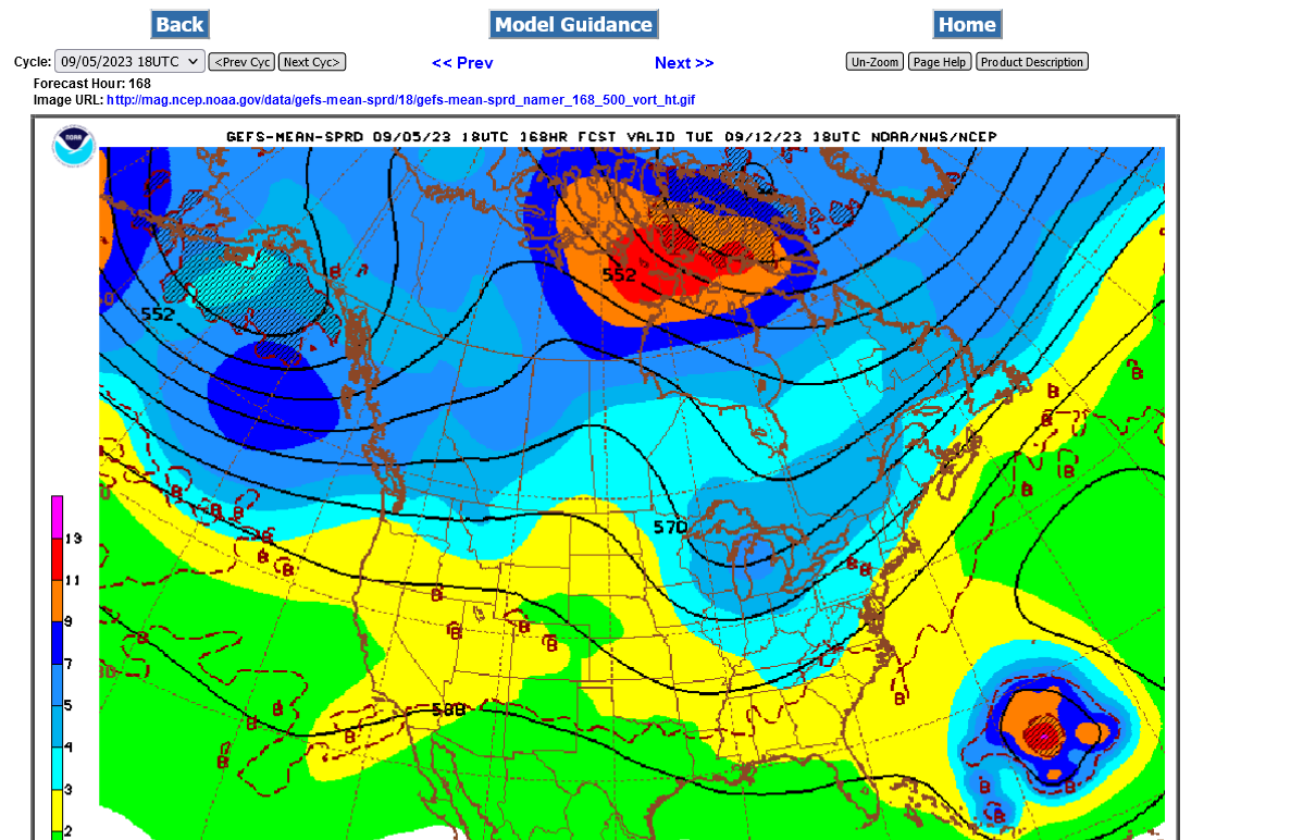
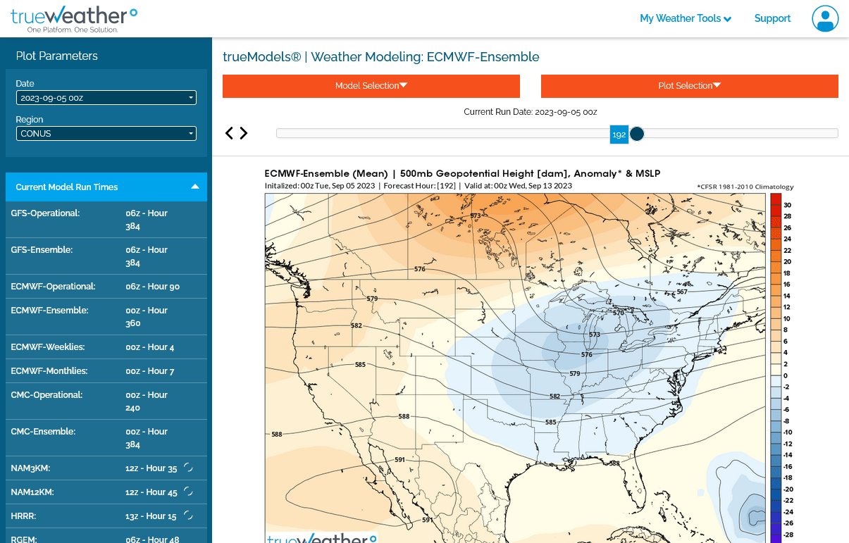
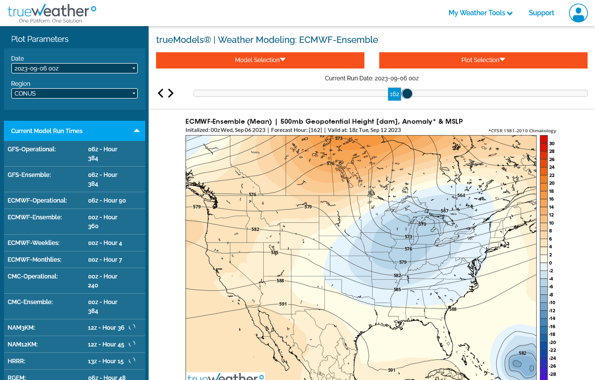
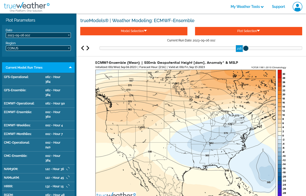
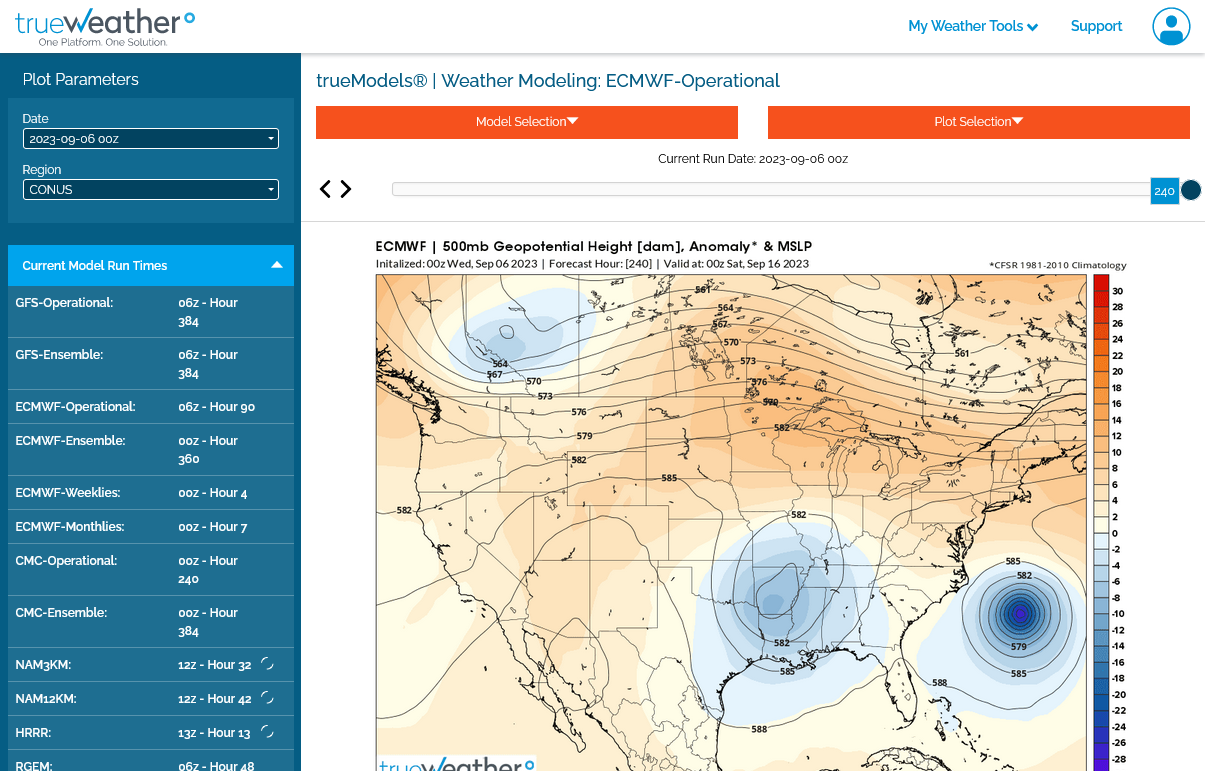
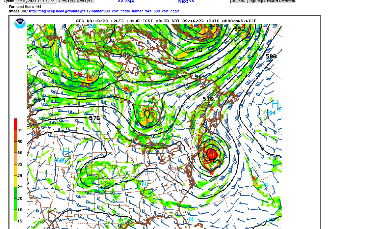
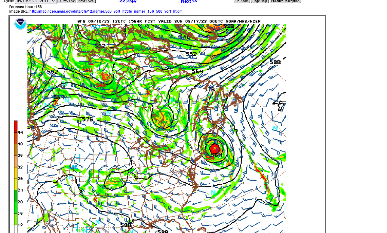
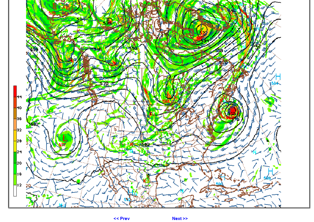
Below is the 500 mb chart for a week from today from the last 18z GEFS model. With this pattern, there is no way a hurricane can fight against the strong west to east steering winds at the time from the upper level trough in the eastern 1/3rd of the country, which will protect the U.S.
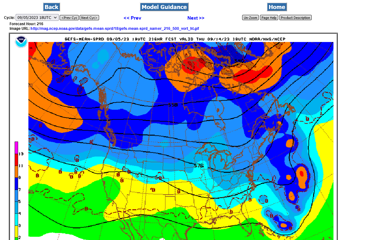
Lee will get picked up by the strong trough, later next week, well out in the W.Atlantic, which is depicted by the 2nd map below.
Thanks, Mike, for your excellent analysis and predictions. It all makes perfect sense and I expect it will work out that way.
The only thing I'll say from what I'm reading from other pro mets (on AmericanWx and elsewhere) is that whereas it appears to be a slam dunk against US landfall (it does to me, too), there remains a small chance for the NE US to have a landfall. The reason given is that with it still close to 10 days out, the models due to inaccuracies that far out COULD (not WILL) be off (wrong) just enough with the upper air troughs, ridges, etc., to allow for a landfall, mainly in the NE US with still virtually no chance for a hit S of NC. Again, this is what I'm reading rather than necessarily my own thoughts.
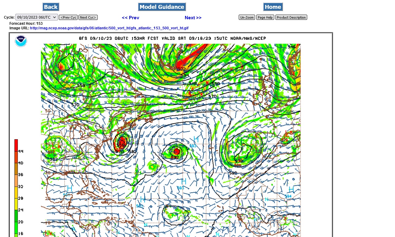
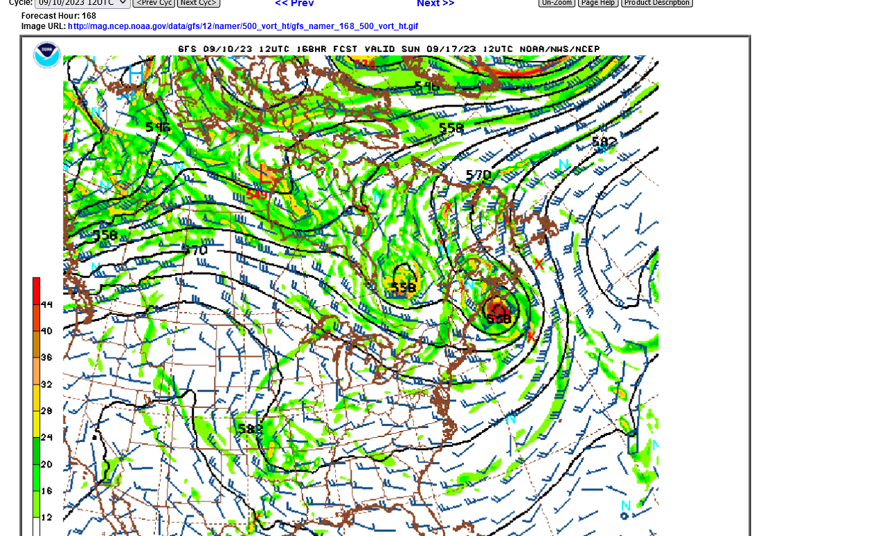
One major model that goes out only 7 days that I do want to alert you to is the UKMET. The 12Z run has it at 168 hours just N of the SE Bahamas still moving slowly WNW (see below). This is ~300 miles W to WSW of the 12Z GFS/Euro. I'm mentioning this model because it has done the best for some storms like for Ian last year, when it was the furthest right the earliest for both the FL and SC landfalls and was with the Euro one of the two best for the Irma FL landfall in 2017 by being furthest left the earliest. In addition, it did better than both the GFS and the Canadian, which were too far left, for the Idalia landfall. IF its 168 hour position of 24.2N, 72.0W, were to come close to verifying, it would be in a much more dangerous position for the NC northward coast vs what the Euro/GFS have.
12Z UKMET: I'm ignoring the winds/pressure because although the UKMET has done quite well with the aforementioned storms, I mean only the track because it is almost always much too conservative with strength:
TROPICAL DEPRESSION 95L ANALYSED POSITION : 13.4N 39.1W
ATCF IDENTIFIER : AL952023
LEAD CENTRAL MAXIMUM WIND
VERIFYING TIME TIME POSITION PRESSURE (MB) SPEED (KNOTS)
-------------- ---- -------- ------------- -------------
1200UTC 05.09.2023 0 13.4N 39.1W 1011 24
0000UTC 06.09.2023 12 13.8N 42.0W 1009 25
1200UTC 06.09.2023 24 14.2N 44.7W 1007 31
0000UTC 07.09.2023 36 15.3N 46.7W 1007 34
1200UTC 07.09.2023 48 16.4N 49.0W 1006 35
0000UTC 08.09.2023 60 17.5N 52.0W 1006 31
1200UTC 08.09.2023 72 18.5N 55.1W 1007 32
0000UTC 09.09.2023 84 19.4N 58.4W 1006 30
1200UTC 09.09.2023 96 19.9N 61.2W 1005 39
0000UTC 10.09.2023 108 20.6N 63.6W 1003 46
1200UTC 10.09.2023 120 21.4N 66.5W 1002 50
0000UTC 11.09.2023 132 21.9N 68.6W 998 52
1200UTC 11.09.2023 144 22.4N 70.2W 998 50
0000UTC 12.09.2023 156 23.9N 71.0W 996 60
1200UTC 12.09.2023 168 24.2N 72.0W 996 46
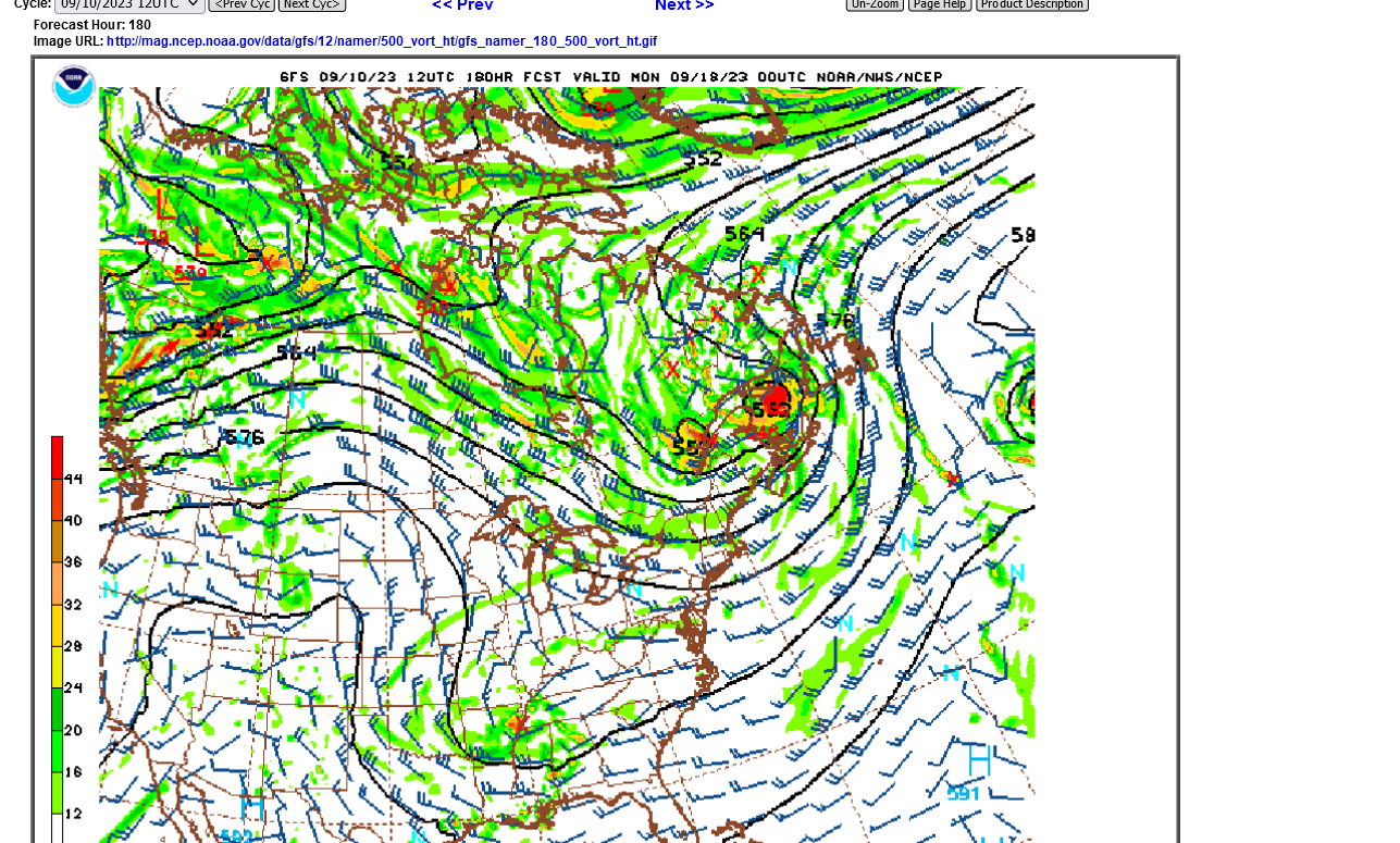
The 0Z UKMET is a bit stronger than the 12Z run. But more importantly, it is recurving 200 miles E of the 12Z run thus implying a significantly lower risk of landfall to the CONUS. Whereas two runs ago it was in the SE Bahamas and the last run was just N of the SE Bahamas, this run is ~250 miles NE of those islands:
TROPICAL STORM LEE ANALYSED POSITION : 13.8N 42.1W
ATCF IDENTIFIER : AL132023
LEAD CENTRAL MAXIMUM WIND
VERIFYING TIME TIME POSITION PRESSURE (MB) SPEED (KNOTS)
-------------- ---- -------- ------------- -------------
0000UTC 06.09.2023 0 13.8N 42.1W 1008 27
1200UTC 06.09.2023 12 14.1N 44.7W 1006 37
0000UTC 07.09.2023 24 15.3N 46.9W 1004 41
1200UTC 07.09.2023 36 16.4N 49.5W 1003 34
0000UTC 08.09.2023 48 17.0N 52.2W 1003 35
1200UTC 08.09.2023 60 17.7N 54.9W 1002 42
0000UTC 09.09.2023 72 18.4N 57.9W 1000 45
1200UTC 09.09.2023 84 18.8N 60.2W 1000 48
0000UTC 10.09.2023 96 19.8N 62.1W 998 53
1200UTC 10.09.2023 108 20.5N 64.2W 998 55
0000UTC 11.09.2023 120 20.8N 65.6W 997 54
1200UTC 11.09.2023 132 21.2N 67.0W 996 52
0000UTC 12.09.2023 144 22.0N 67.7W 993 54
1200UTC 12.09.2023 156 23.3N 68.0W 987 51
0000UTC 13.09.2023 168 24.4N 68.9W 977 56
Last 5 Euro ens runs (0Z and 12Z only): # of members with CONUS H landfall
0Z 9/6: 5 (10%)
12Z 9/5: 2 (4%)
0Z 9/5: 4 (8%)
12Z 9/4: 1 (2%)
0Z 9/4: 2 (4%)
So, although still a small %, the latest run has the highest yet.
Great stuff, Larry!
Thanks for alerting us to the possibility of it hitting the US East Coast increasing.
One thing I've learned from 4 decades of meteorology is never say never on a forecast for week 2 in a situation like this. Model skill for that period is not great enough to know with absolute impunity that the large scale upper trough in the East will be there when the hurricane approaches. There could be a delay or change in the northern stream trough reinforcement energy that causes a pocket of light winds ahead of the reinforcement for a day or 2 in the Southeast, just as the hurricane is approaching that allows it to sneak UNDER the trough and approach and even hit the coast.
Let me show you what I mean with the last 3 runs of the 0z EE. I'm using different time frames because the speed and position of the hurricane changes with each run.
It all depends on the northern stream, upper level trough depth and timing.
1. 0z EE from 2 days ago below. Upper level trough and stout steering winds blowing from the East Coast out to the Atlantic all the way down to the deep Southeast make it IMPOSSIBLE for the hurricane to hit the East Coast.
2. EE from 24 hours ago. Note the Upper level trough reinforcement is delayed and a tad farther west which allows the hurricane(coming in farther south) to track closer to the East Coast!
3. The last 0z EE has the northern stream trough not quite as deep in the Southeast and the hurricane is sneaking in, farther south and just under it's influence AT THAT TIME.
4. HOWEVER, A couple days later, this last 0z EE deepens the far southern part of the trough and makes it almost impossible for Hurricane Lee to continue west:
5. Look at this crazy, outlier operational European model solution from the last 0z run. This is why we should never say never. If the upper level trough in the US would cut off that far southwest, the impact along the MidAtlantic or Northeast coast would be minimal and allow the hurricane to have a chance to hit there.
Larry,
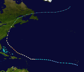
I'm starting a new thread on Super Storm Sandy because of "some" similarities to this current set up.
It will have numerous maps and this thread is already pretty long.
In late Oct. 2012, the deep upper level northern stream trough was expected to steer Sandy away from the coast(like this one but we're not nearly so deep this time), then suddenly the models realized the upper level trough would PULL IN Sandy and the 2 systems became a super energized hybrid storm.
I prove conclusively here too, that Superstorm Sandy was not caused by climate change with even stronger Hurricane Hazel in 1954(and others) doing the exact same thing.
Going to be a close call on whether Lee can get picked up by the trough to the west(like Superstorm Sandy-2012 and SuperDuperstorm Hazel-1954) or whether the trough steers it/keeps from hitting the coast.
Right now, almost all the guidance keeps Lee off the coast.......but it gets dangerously close and we have a week to go. Things can change.
Last 6z GFS operational model in 8 days.
If the trough is deeper(farther south) and farther west than expected here, the hurricane has an increasing chance to hit the coast.
That could also happen if the hurricane is farther northwest.
Those are only "could's" but have low probabilities right now.
The 0Z EPS (Euro ens) of today had a total of 5 ME and 5 MA) for a full 0Z EPS total of 10 (20%), which doubles the previous run highest hit total of 5 (10%) that was from the run 24 hours earlier.
Summary of EPS (0Z and 12Z) runs' CONUS hits:
0Z 9/7: 10 (20%) (9/15-18) (5 ME, 5 MA)
12Z 9/6: 3 (6%) (ME 9/15 & 9/17, MA 9/18)
0Z 9/6: 5 (10%)
12Z 9/5: 2 (4%)
0Z 9/5: 4 (8%)
12Z 9/4: 1 (2%)
0Z 9/4: 2 (4%)
Thanks a ton, Larry.
After I viewed the NHC forecast for Superstorm Sandy and the incredible change in just 36 hours, it made me better appreciate the potential for big changes here with a week+ to go.
Maps below:
1. This was the last 12z GFS operational model forecast for a week from today.
2. Atlantic view-this one really shows similarity with #3/Sandy but just not amplified enough with an Omega block that was in place late Oct. 2012.
3. The set up with Sandy
The players are there for the potential for the trough to capture the Hurricane Lee except there's no huge omega block to the north that we saw with Superstorm Sandy.
A very powerful shortwave seen on map #1 dropping out of far southcentral Canada, will kick out the low/trough in the Great Lakes which is the main feature capable of capturing Lee. However, if that energy moves fast enough, it could try to capture the remnants of Lee when its in the vicinity of southeast Canada or even the Northeast US!!
The biggest risk appears to be the far northeast U.S. and southeast Canada that juts out so far east into the Atlantic and the stronger approaching trough to the west possibly having an impact.
1. 1 week from today, US view below
2. 1 week from today, Atlantic view below
3. Late October 2012 below-compare to map #2 above for a week from today
https://www.marketforum.com/forum/topic/98751/#98753

Just to repeat, Superstorm Sandy, just like Hurricane Hazel in 1954, during global cooling and a few others, was crystal clearly NOT impacted by global warming/climate change.
There were several major hurricanes in the 1953 and 1954 season that took similar tracks to what's being predicted for Lee.
1953
https://en.wikipedia.org/wiki/1953_Atlantic_hurricane_season
1954
https://en.wikipedia.org/wiki/1954_Atlantic_hurricane_season
Thanks, Mike.
I count on the 12Z EPS 12 (24%) US hits meaning the most of any run yet with 7 ME, 3 MA, 1 NY, and 1 NJ with hit dates 9/15-19.
Summary of recent EPS runs' US hits:
9/7 12Z: 12 (24%) 9/15-19 (7 ME, 3 MA, 1 NY, 1 NJ)
9/7 0Z: 10 (20%) 9/15-18 (5 ME, 5 MA)
12Z 9/6: 3 (6%) 9/15-18 (2 ME, 1 MA)
0Z 9/6: 5 (10%)
12Z 9/5: 2 (4%)
0Z 9/5: 4 (8%)
12Z 9/4: 1 (2%)
0Z 9/4: 2 (4%)
I DON'T KNOW MUCH ABOUT NUMBERS, ETC., BUT.... 5 MINUTES AGO... LEE HAS TURNED MY STOMACH. I'M PRAYIN', HARD THAT HE VEERS BACK INTO THE OCEAN, INSTEAD OF LAND.
Lots of uncertainty and time still, Jean.
Lee very unlikely to hit anywhere south of New England, when/IF it's absorbed into the large scale, mid latitude upper level trough a week or longer from today.
It appears that Lee peaked earlier this morning at 165 mph. Now down to 155 mph.
Scroll down for more!
Earlier this morning, the forecast was for it to strengthen from 165 mph up to 180 nph but instead, the sustained wind speed dropped to the current 155 mph.
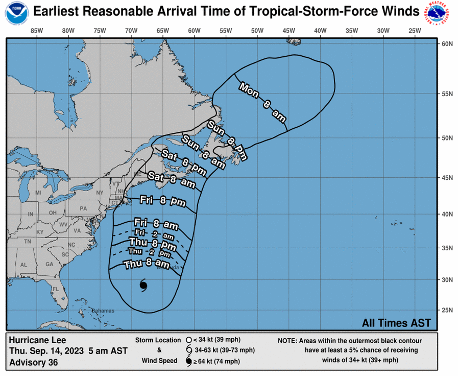
You can get all the previous advisories on Lee here:
https://www.nhc.noaa.gov/archive/2023/LEE.shtml?
| 12: 500 AM AST 13: 1100 AM AST |
Still a week from any potential hit in the Northeast US/Southeast Canada.
Weather models don't have the skill to accurately pinpoint a feature like this that far in advance.
Large scale upper levels and major patterns, YES! but the location of a specific storm, hurricane remnant or perturbation, NO!
All the potential tracks being discussed this week are very speculative. My posts on 1950's hurricanes and especially SuperStorm Sandy-2012 are NOT meant as guidance for this one and in fact, with Sandy and Hazel-1954 are meant to show why this one is DIFFERENT and is less of a threat compared to those historical storms.
Atlantic water temperatures main page:
https://www.ospo.noaa.gov/Products/ocean/sst/contour/
US Atlantic. Note the cooler water left behind by Franklin and help from Idalia.
https://www.ospo.noaa.gov/data/sst/contour/usatlant.fc.gif
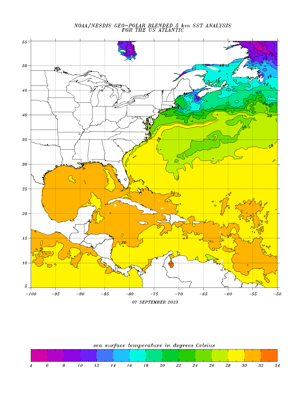
Here's a better look at it:
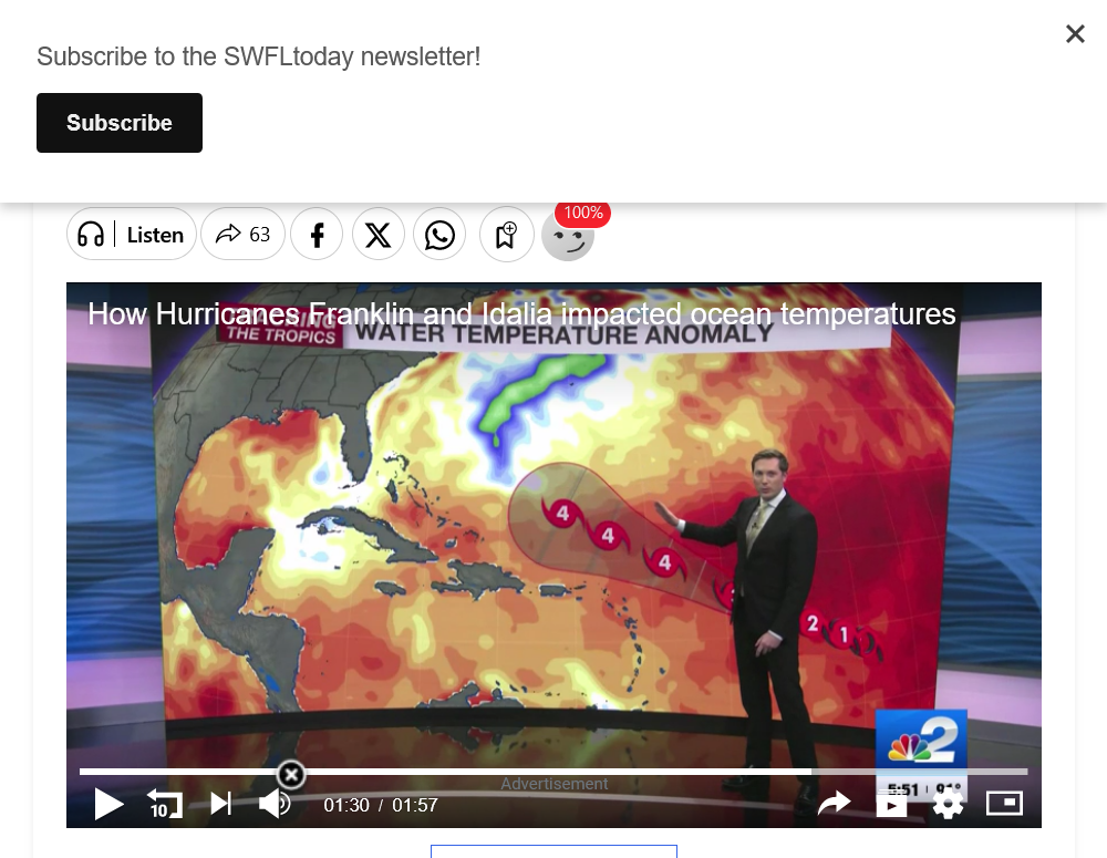
How Hurricanes Franklin and Idalia impacted ocean temperatures

++++++++++++++++++++++++
If/when Lee moves into that cooler water, it will be impossible to maintain major hurricane status.
The temperature needed to sustain a hurricane is 26+ Deg. C and the water temp in that huge band of cooler water is still just above that, so Lee can maintain hurricane status but will weaken a bit.
When Lee gets MUCH farther north, if it takes aim on the Northeast or Southeast Canada that juts way east into the Atlantic, it will no longer be a hurricane. Water temps are well below 26 Deg. C.
It will likely be called an extra tropical storm that no longer generates its energy from the very warm ocean temperatures and heat generated from the massive latent heat of condensation being released above 26 Deg. C water and the warm core.
+++++++++++++++++++++++
This is why the interaction with the mid latitude trough will be a key to how powerful the remnants of Lee will be.
Superstorm Sandy-2012 was only a Superstorm because of the cold pattern, -NAO, deep upper level trough that captured it.
The remnants of Hazel-1954 tracked over land for a thousand+ miles, cut off from the ocean but obliterated Canada because the mid latitude trough that captured it was so strong/deep!
https://www.marketforum.com/forum/topic/98751/#98756
Hurricane Hazel
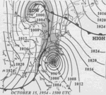
Upper levels below for Oct 15/16, 1954 as they picked up Hazel.
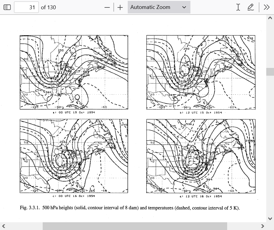
++++++++++++++++++++
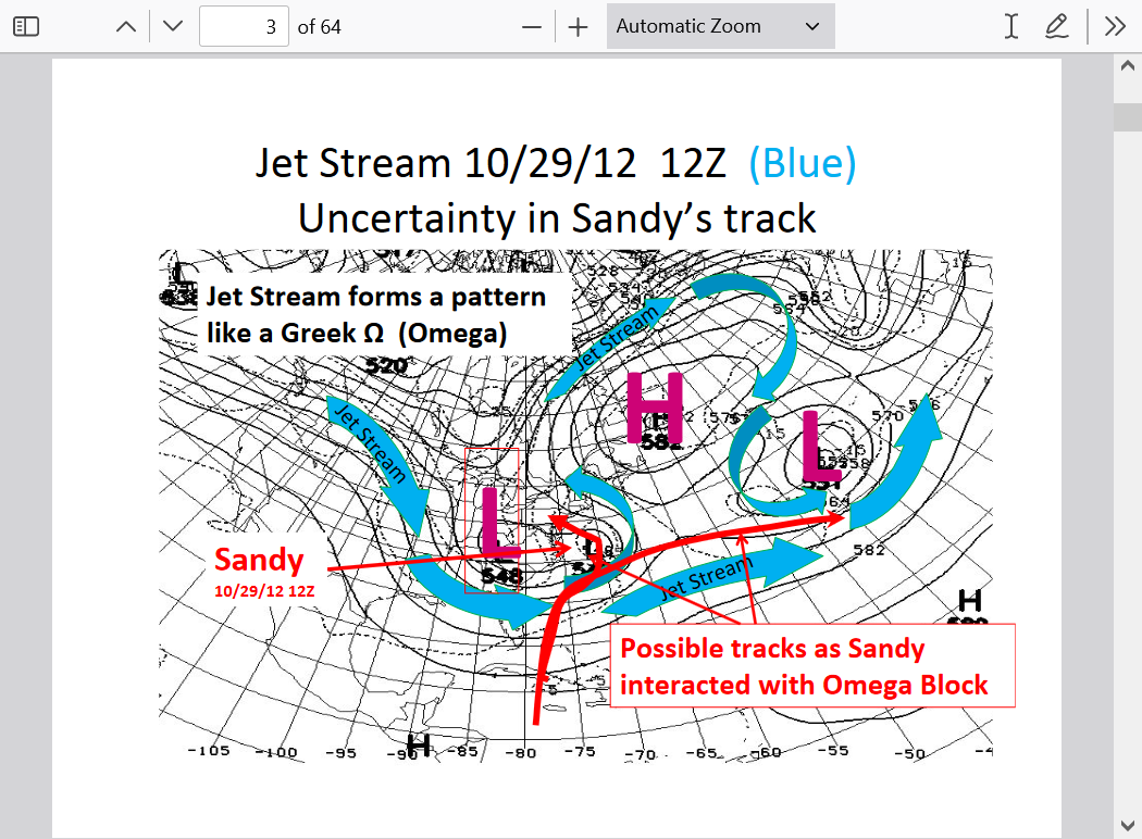
Upper levels below on Oct 29, 2012 as they picked up Sandy.
https://www.marketforum.com/forum/topic/98751/#98753
So the main chance for Lee to become any sort of SuperStorm for New England or Southeast Canada lies in the position and strength of the mid latitude upper level low.
The upper level low must capture it and turn it into a hybrid type storm that combines their strengths.
If it doesn't get captured, Lee's remnants can still be pretty powerful, especially along the coast but they will move much faster and farther east and not be a Superstorm/hybrid.
https://www.cnn.com/2023/09/08/weather/hurricane-lee-path-friday-climate/index.html
Lee hit a rare strength that few storms have ever achieved. Only 2% of storms in the Atlantic reach Category 5 strength, according to NOAA’s hurricane database. Including Lee, only 40 Category 5 hurricanes have roamed the Atlantic since 1924.
Category 5 is the highest level on the hurricane wind speed scale and has no maximum point. Hurricanes hit this level when their sustained winds reach 157 mph or higher. A 165-mph storm like Lee is the same category as Hurricane Allen, the Atlantic’s strongest hurricane on record, which topped out at 190 mph in 1980.
+++++++++++++++++++++
How did all those other stronger hurricanes happen before climate change/global warming??
https://www.marketforum.com/forum/topic/98571/#98631
++++++++++++
Keep in mind that if not for the age of technology, we would have had no idea that Lee hit 165 mph earlier today!
Less than a century ago, we had to measure the speed when the hurricanes hit land.
https://en.wikipedia.org/wiki/Hurricane_hunters
++++++++++
I flew into Hurricane Gloria in Sept. 1985 in a hurricane hunter with the National Hurricane Center!
You will note that Gloria made it on this list below(150+ mph) and is actually a bit similar to this one(but tracked farther west than Lee's predicted track)!
https://en.wikipedia.org/wiki/List_of_the_most_intense_tropical_cyclones
Hurricane Gloria
https://en.wikipedia.org/wiki/Hurricane_Gloria
https://connecticuthistory.org/hurricane-gloria-storm-of-the-century/
+++++++++++++++++++++
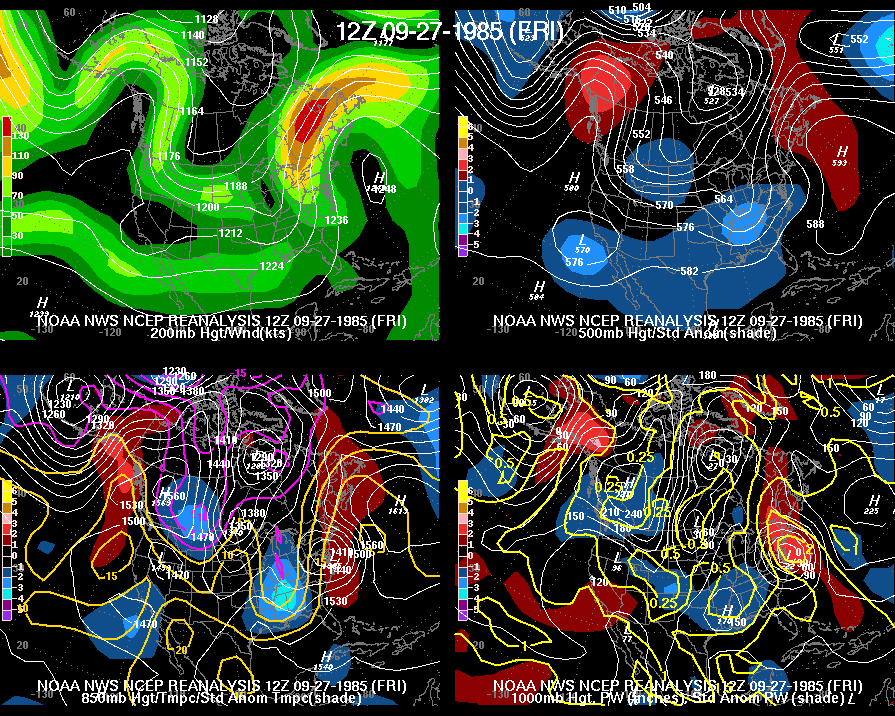
The weather maps/synoptic meteorology for Gloria below, were a bit DIFFERENT than what we have now steering Hurricane Lee, with a 593 DM, 500 mb high in the W.Atlantic much closer to the East Coast then(top right) and very extensive from north to south, causing Gloria to go farther west.
http://www.wpc.ncep.noaa.gov/ncepreanal/
Here's the last 12z GFS operational for 7.5 days from now. If the small but significant 595 DM high builds farther west, it will force the remnants of Lee to also hit the East Coast farther west. This is actually one of the most bullish runs that I've seen so far.
Thanks, Jean.
last NHC update dropped winds of Lee to 115 mph.
the models and forecasters really busted the last 24 hours on the intensity.
instead of strengthening to 180mph, Lee weakened to 115 mph.
that’s a 65 mph miss in the middle of the ocean.
Not a major hurricane at the moment but should be back to 130+ in a few days if the NHC is right.
looks like the peak was early Friday.
Lee continues at 50 mph less than early yesterday morning because of some wind sheer and 65 mph less than the forecast and is predicted to remain close to this for a couple of days then get back to 140 mph. Tons of uncertainty. We couldn't even predict the intensity in 24 hours, let alone the intensity and location in 1 week.
Lee and climate change
Started by metmike - Sept. 9, 2023, 10:20 a.m
Last 12z Operational European model for next Sunday Evening. Trough to the west is capturing Lee's remnants.
Most models/solutions don't have this. A week to go.
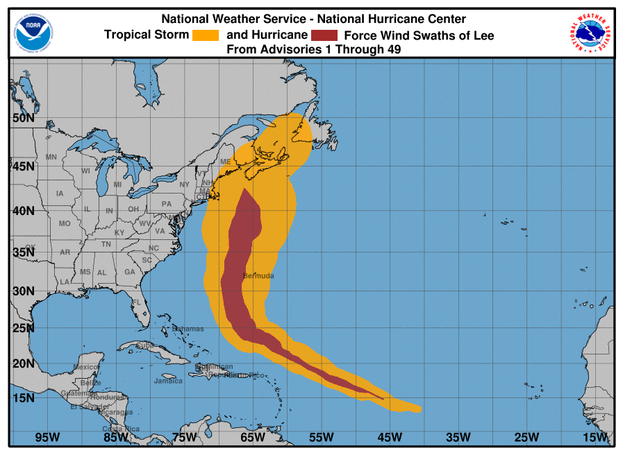
The color bars are WIND GUSTS. Greens up are hurricane force!
Lee down to 105 mph.
forecast to strengthen the next few days back to 140 mph.
maybe
Lee still at 105 mph. Forecast to strengthen for a few days then down to 90 mph by day 5. Still and extremely small chance of the remnants getting picked up by a trough to the west and becoming a major storm that clobbers the Northeast with a better, but still not likely chance of it brushing the Northeast US/Southeast Canadian coast.
I've been picking the most bullish models to show how this MIGHT happen, not the ones most likely to verify. I show the upper levels because they will determine the path/steering for the storm.
1. Last operational 6z GFS in the Atlantic next weekend. Omega shaped upper level high location in the Atlantic is important.
2. Last 0z Canadian model that's more bullish with the strong chunk of energy dropping into the Great Lakes/upper level low. How that interacts with the remnants of Lee might be a key factor, especially for Lee to have any chance of making landfall on the coast in the Northeast(it will still need to be much deeper than even the Canadian's outlier deep solution here).
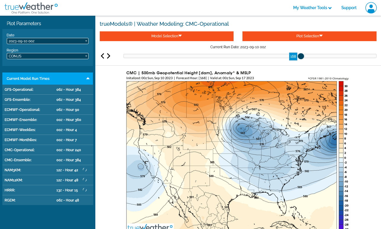
This is the last 12z operational GFS model that shows the mid latitude, northern stream perturbation/upper level trough entraining the remnants of Lee in a similar but less powerful way that Superstorm Sandy turned into a hybrid storm. The first map is Saturday am, last one 48 hours later. The maps are spaced 12 hours apart and end Monday morning. THIS IS ONE SOLUTION and contrasts with the majority.
Below those 5 maps, is the last 12z Canadian model(upper levels) it's strongest with the trough to the west but keeps the 2 storms separate. Like all the other solutions, this is too far out and models don't have the skill to predict this event accurately right now but it tells us what is possible, even likely.
Finally, the last 12z European model shows a completely different solution as far as the trough and Lee interacting.
Regardless of the solution, it's clear that the far Northeast U.S. and especially the Southeast Canadian Atlantic are LIKELY potential targets.
Canadian model below
European model below
For record/trend following purposes, GEFS US initial landfalls: 12Z had a drop to 6 (19%) (3 ME, 2 MA, 1 NJ/NYC) with only one strong left hooking member. Almost all of the rest have initial landfall into NS or via the Bay of Fundy into NB.
Last 13 GEFS runs: 19%, 32%, 29%, 26%, 42%, 10%, 13%, 26%, 16%, 16%, 10%, 10%, 10%
Thanks, Larry!
Interesting to note that most of the 12z Canadian ensembles try to entrain the remnants of Lee into the upper level trough to the west. Most solutions on other models don't have this.
https://weather.gc.ca/ensemble/charts_e.html?Hour=144&Day=0&RunTime=00&Type=pnm
156h GZ 500 forecast valid on Sep 17, 2023 12UTC


Forecasts for global GEM, control (GEM 0) and the 20 ensemble members
YW, Mike.
For trend following purposes for those who like following these and for the record here are EPS 0Z/12Z run US landfalls, which have resulted in three runs in a row with 20%+. That's a significant %, but OTOH the rising has stopped for now and it is still well under 50%:
9/11 12Z: ~11 (22%): ~9 ME, 2 MA
9/11 0Z: ~12 (24%): ~9 ME, 1 MA, 1 RI, 1 NY
9/10 12Z: 10 (20%): 6 ME, 3 MA, 1 RI
9/10 0Z: 3 (6%): 1 ME, 2 MA
9/9 12Z: 6 (12%) 9/17-19 (3 ME, 3 MA)
9/9 0Z: 3 (6%) 9/17 (3 ME)
9/8 12Z: 5 (10%) 9/15-18 (5 ME)
9/8 0Z: 7 (14%) 9/15-17 (6 ME, 1 NY)
9/7 12Z: 12 (24%) 9/15-19 (7 ME, 3 MA, 1 NY, 1 NJ)
9/7 0Z: 10 (20%) 9/15-18 (5 ME, 5 MA)
9/6 12Z: 3 (6%) 9/15-18 (2 ME, 1 MA)
9/6 0Z: 5 (10%)
9/5 12Z: 2 (4%)
9/5 0Z: 4 (8%)
9/4 12Z: 1 (2%)
9/4 0Z: 2 (4%)
Aside: 12Z op hit W NS at 969 mb very early on 9/17
Thank you, Larry!
Lee will be tracking over the wake of Idalia and Franklin and weakening a bit later this week. https://www.marketforum.com/forum/topic/98675/#98813
By late weekend, water temps crash north of the Gulf Stream and that should kill hurricane intensity winds.
https://www.nhc.noaa.gov/refresh/graphics_at3+shtml/204322.shtml?cone#contents
https://www.nhc.noaa.gov/text/refresh/MIATCDAT3+shtml/112044.shtml?
Updated 1:39 am September 12, 2023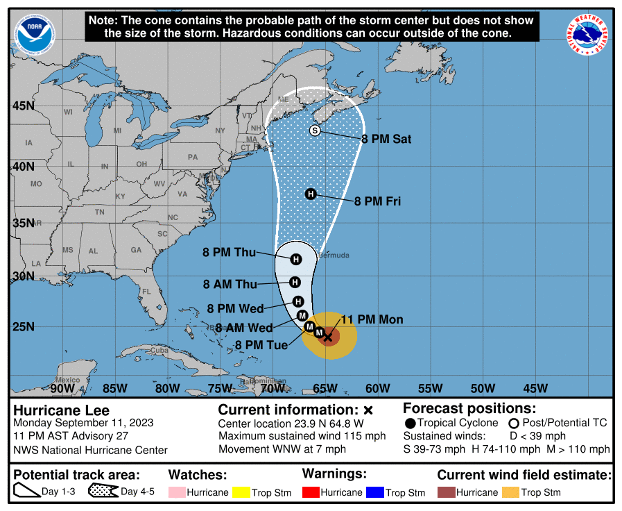
YW Mike.
1. The 0Z Euro hits the C ME coast ~8AM on 9/17 at 972 mb.
2. The 0Z Euro ens looks like it has the highest % of members with a US landfall yet. There are so many that it will be very hard to count them. Most by far are in ME. It looks like ~4 in MA. I'm roughly guessing 12-15 in ME, where the rest are.
3. The odd thing is that the 0Z GFS ens had the smallest # of US hits in quite awhile with only 4 (13%) vs the 0Z Euro ens' ~31%+!
4. Also odd is that the 0Z CDN ens has only one US hit, the smallest # on it since way back at the 0Z 9/9 run!
5. Also odd is that the 0Z Euro is the only 0Z op model that hit the US. The GFS barely missed and the others were further away.
Thanks much, Larry!
That is odd and as we know, part of fun challenge in following weather guidance ahead of big events like this.
3 additional things to note.
1. The storm will be huge in size
2. The storm will be moving pretty fast when it approaches the coast.
3. Because of #2, the far left side of the storm will have reduced wind speeds. The far right side, that has the biggest increase in surface winds from the storms forward motion will be facing the ocean, however, if the track is far enough west/to the left and it tracks a bit inland, areas that are immediately on the right side of the center could have an added 25 mph to winds in a narrow path that would be just east of the track
1. The 6Z GEFS was pretty similar to the 0Z GEFS except there was actually a slight increase vs 0Z up to 5 US landfalls vs 4 including 2 MA hits vs 0 MA on the 0Z. But the 6Z GEFS (19% US hits) is still not as active as the EPS (31%+).
2. Whereas the 6Z Euro op shifted slightly E of the 0Z Euro op, the 6Z EPS actually shifted even further W vs the 0Z EPS. Check out MA, for which the 0Z EPS had 4 landfalls. The 6Z EPS has ~8 MA landfalls in addition to 2 on the RI/MA border and another offshore ready to come in as of the end of the run! So, whereas the 0Z EPS had 4 US landfalls outside of ME, the 6Z EPS has ~11 of those!
-------
**EDIT to add this:
EPS prior two runs: The very active 0Z EPS still had only 4 (8%) of members hit the NE US outside of ME. The 6Z EPS had ~11 (22%)! That was by far the highest % with US landfalls outside of ME for any EPS.
12Z EPS: is back down to ~5 MA landfalls. ME still has a bunch though I think they decreased some. So, the new EPS is still quite active in regard to NE US landfalls but the mean track did shift a bit E vs the 6Z.
Thanks much for that update Larry!
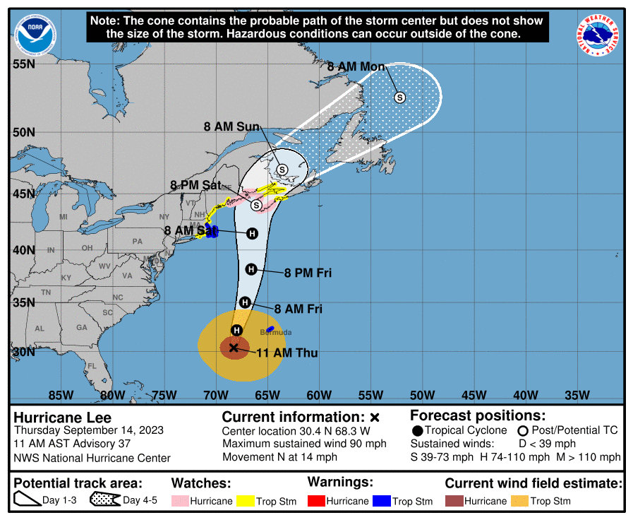
We're at the stage where the window is closing and confidence rising, with the 5 day NHC cone now showing almost the entire period of concern, though, as you noted we can see how wide the spread still is in the cone over the weekend.
https://www.nhc.noaa.gov/graphics_at3.shtml?start#contents
https://www.nhc.noaa.gov/refresh/graphics_at3+shtml/211441.shtml?cone#contents
Word is going around down east Maine to expect some corn gets laid down. How much wind est will Portland/Augusta area get?
I count ~15 on the 18Z EPS with a non-Maine US landfall, which is even more than the ~11 on the 6Z!
WX------------Meaning landfall east of USA into Canada?
Hi tjc,
No, the 15 (30%) 18Z EPS (Euro ensemble) members that I'm saying are non Maine US landfalls hit MA, RI, NH, Long Island, and CT. There are still ~15 (30%) that landfall in Canada either in S NS or NB. That leaves ~21 (42%) first hitting ME.
Thanks, Larry!
Beckah,
The possible range of winds for Maine are very wide, depending on the track.
ill have more tomorrow but the areas east of the center could have winds of +25 mph compared to those west.s
If the storm takes a path west of the state of ME, it’s bad news with wind gusts up to 70? Only a very small chance of that.
Completely east of ME for the remnants track and maybe peak wind gusts staying under 50?….that seems like a good bet right now.
im On the high side because this storm will be huge And could be getting picked up by an upper level trough to accelerate the speed
Lots more tomorrow!
Some 12Z run landfalls:
-Arpege: NB very late 9/16 980 mb
-ICON: NB early 9/17 975 mb
-GFS: NB early 9/17 976 mb
-CMC: SW NS early 9/17 981 mb
-UKMET: SW NS late 9/16 966 mb
-JMA: Cape Cod 8PM 9/16 963 mb
-Euro: NB hour 90 early 9/17 974 mb
-KMA: E corner ME 5PM on 9/16 962 mb
Thanks, Larry!
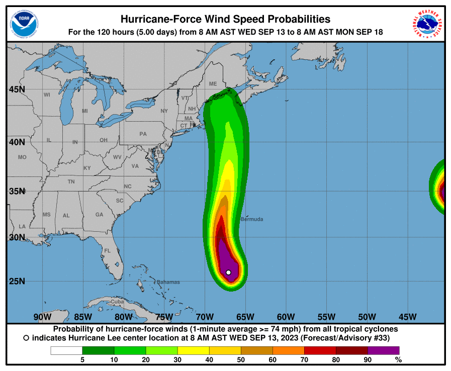
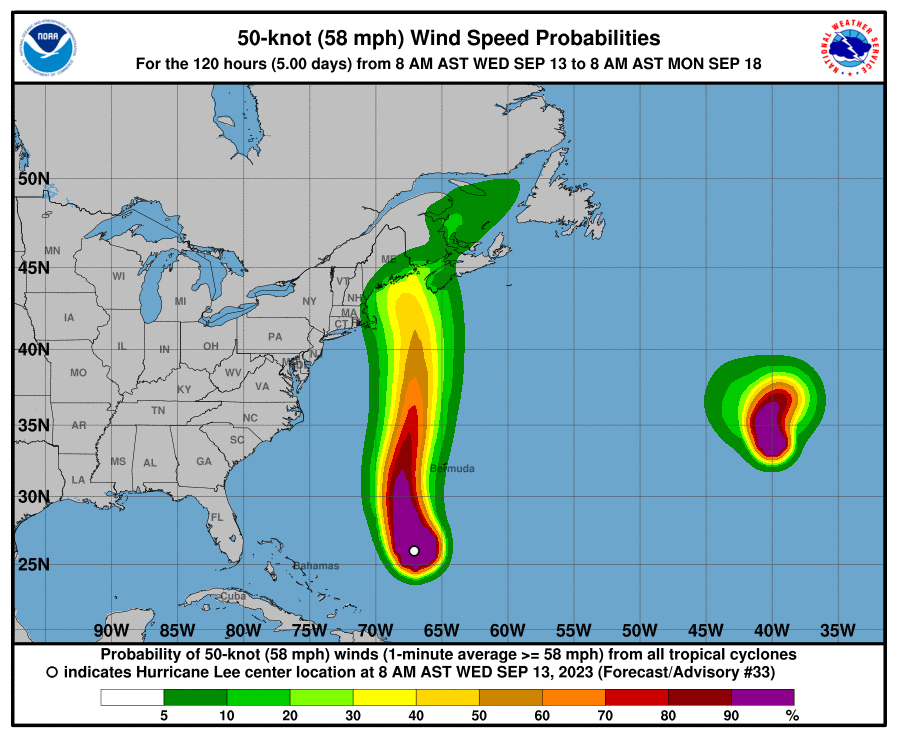
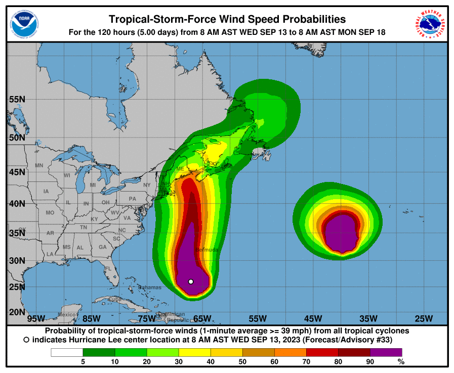
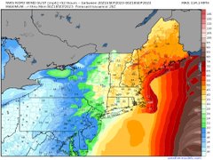
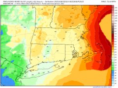
Here's a useful product with regard to wind speeds. This product is very likely UNDER predicting the wind speed potential, especially since the storm will be massive and the model that they use to compute these values doesn't properly dial that in.
I would bet big money that the 2nd map for 58 mph wind speeds, is better depicted with the color coding on the 3rd map, which applies to 39 mph wind speed probabilities. In other words, add 20 mph to what the model thinks outside of the typically small eye wall(maybe 200 miles from the center this time)?
However the accelerating forward speed in the north direction (that will add to winds on the right side and take away from winds on the left side) might end up reducing the winds in the Northeast U.S.
The entire state of Maine looks to be on the left/west side of the path(of the center) with the last guidance, as Larry showed, with the exception of the JMA model. This would help reduce winds speeds. The right front quadrant with respect to direction always has the highest winds for a fast tracking storm.
https://www.actionnews5.com/2018/09/16/breakdown-what-is-strongest-side-hurricane/
+++++++++++++++
https://www.nhc.noaa.gov/refresh/graphics_at3+shtml/174606.shtml?tswind120#contents
 +++++++++++++++++++++++++++++
https://www.unidata.ucar.edu/data/NGCS/lobjects/chp/structure/
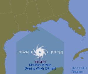
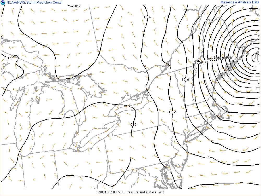
The Right Side of the StormAs a general rule of thumb, the hurricane's right side (relative to the direction it is travelling) is the most dangerous part of the storm because of the additive effect of the hurricane wind speed and speed of the larger atmospheric flow (the steering winds). The increased winds on the right side increase the storm surge described in the Hazards section of this module. Tornadoes are also more common here.Looking at the figure above, pretend you are standing behind the hurricane with your back to the steering flow. In this case, the right side is the eastern section of the hurricane. (If it were travelling east to west, the right side would be the north section.) The winds around the hurricane's eye are moving in a counterclockwise fashion. At Point A, the hurricane winds are nearly in line with the steering wind, adding to the strength of the winds. For example, if the steering currents are 30 mph and the average hurricane winds are 100 mph, the wind speed would be 130 mph at Point A. On the other hand, the winds at Point B are moving opposite those of the steering wind and therefore slow to 70 mph (100 - 30 mph). Incidentally, NHC forecasts take this effect into account in their official wind estimates.
++++++++++++++++++
This last lesson is one to remember for the rest of your life because it applies to almost every storm, including mid latitude surface lows/cyclones/Winter storms based on the physical laws of the atmosphere!
Forgot to mention. Those probabilities on the forecast graphics above are for sustained winds. Gusts could be 20+ mph higher than that, especially along the coast with less friction from land.
Coastal areas of the far Northeast U.S. (Boston northward) could see 70 mph wind gusts, considering the size of the system and the intense pressure gradient from a deep surface low.
Hurricane Lee will become post-tropical as it reaches mainland Maine/New Brunswick late Saturday. However, up to hurricane force wind gusts could lash the New England coast including Boston. Any further track adjustments to west would shift wind threat inland. Margot and Nigel are watching Lee from a distance.
Some 0Z 9/14 run landfalls:
-Arpege: SW NS early 9/16 968 mb (faster and E shift vs 12Z's NB)
-ICON: NB early 9/17 981 mb (similar to 12Z)
-GFS: NB early 9/17 976 mb (similar to 12Z)
-CMC: SW NS late 9/16 980 mb (slight W shift vs 12Z)
-UKMET: SW NS late 9/16 970 mb (slight E shift vs 12Z)
-JMA (inferior): C ME early 9/17 973 mb (NE shift vs 12Z, which crossed CC)
-Euro: NB early 9/17 976 mb (similar to 12Z)
-KMA: SW NS midday 9/16 ~960 mb (big E shift vs 12Z's E ME)
Thanks much, Larry.
One would think that we are really honing in on the track and intensity but we can't forget the sudden, extreme shift westward in Superstorm Sandy in Oct 2011 as an example of a late forecast surprise.
https://www.marketforum.com/forum/topic/98751/#98752
Here's another insightful graphic from the awesome NHC:
https://www.nhc.noaa.gov/refresh/graphics_at3+shtml/090725.shtml?3-daynl
https://www.nhc.noaa.gov/refresh/graphics_at3+shtml/090725.shtml?mltoa34#contents
Lee is very unlikely to do another SuperStorm Sandy act because the mid latitude trough to the west, as seen here early Saturday from the just updated 6z GFS is too far to the west to pick up and entrain Lee and combine the 2 into 1 hybrid super charged storm like what happened with SuperStorm Sandy (having 0 to do with climate change/global warming-that was made up.
You can view the upper level trough picking up Sandy in Oct. 2012 and turning it into a SUPER storm here(very unlikely this time)
https://www.marketforum.com/forum/topic/98751/#98754
Thanks, Mike.
-Out of twelve 0Z 9/14 models including the 4 tropical models and excluding the NAM, the only one showing a US landfall was the lowly JMA (central ME). And the JMA shifted away from Cape Cod since 12Z. How far off does the 0Z JMA, even after its significant NE shift, appear to be? It is to the left of all 51 members of the last three EPS runs ending with today's 6Z run:
-Recent EPS Runs' US Landfalls: going down
9/14 6Z: 6 (12%) 6 ME
9/14 0Z: 7 (14%) 7 ME
9/13 18Z: 10 (20%) 10 ME
9/13 12Z: 14 (27%) 13 ME, 1 MA
9/13 6Z: 35 (69%) 27 ME, 6 MA, 2 RI
9/12 18Z: 36 (71%) 21 ME, 9 MA, 3 RI, 3 NY (LI)
Thanks, Larry,
Is this something the JMA has done before? Odd!
The updated NHC has almost the entire cone east of ME, with the exception of the tip of eastern border.
https://www.nhc.noaa.gov/refresh/graphics_at3+shtml/150936.shtml?cone#contents
Mike said:
"Is this something the JMA has done before? Odd!"
------------
Based on my recollection of my observing the JMA over the years, it has a pretty strong left bias for tropical cyclone positions. So, this isn't shocking.
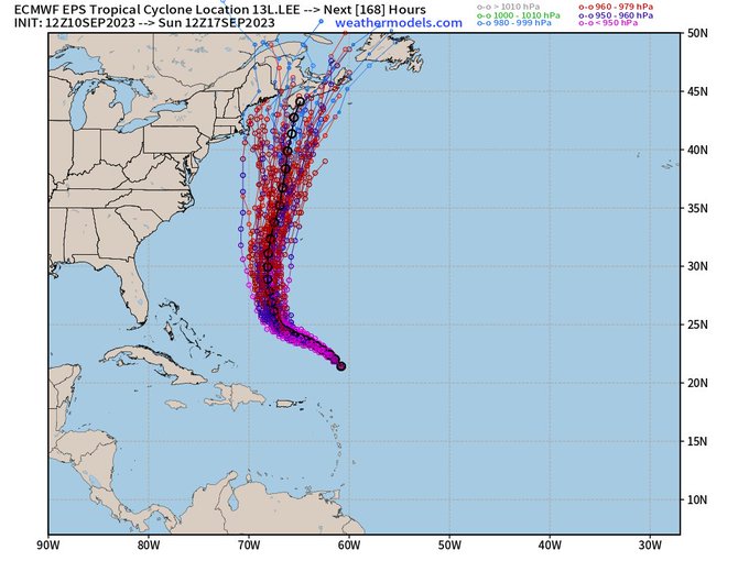
Thanks for that, Larry. You've been very informative with Lee in passing on the spaghetti plot results and more.
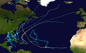
https://en.wikipedia.org/wiki/Spaghetti_plot
A spaghetti plot (also known as a spaghetti chart, spaghetti diagram, or spaghetti model) is a method of viewing data to visualize possible flows through systems. Flows depicted in this manner appear like noodles, hence the coining of this term.[1] This method of statistics was first used to track routing through factories. Visualizing flow in this manner can reduce inefficiency within the flow of a system. In regards to animal populations and weather buoys drifting through the ocean, they are drawn to study distribution and migration patterns. Within meteorology, these diagrams can help determine confidence in a specific weather forecast, as well as positions and intensities of high and low pressure systems. They are composed of deterministic forecasts from atmospheric models or their various ensemble members. Within medicine, they can illustrate the effects of drugs on patients during drug trials.
You're welcome, Mike.
I'll add these two most recent EPS runs:
9/14 12Z: 11 (22%) 10 ME, 1 MA (CC)
9/14 18Z EPS had a mere two (4%) US landfalling members and they were on the far E end of ME. So, it's looking very good for no US landfall.
Without power here overnight for unknown reasons under clear skies but there doesn’t look like any potential surprises with Lee Coming up.
Larry started this thread 2 weeks ago with a title that couldn’t have been more appropriate in describing the future of a wave that would become Hurricane Lee.
Hats off to WxFollower!
RyanMaue
With Lee tracking enough east into the Bay of Fundy, the wind gusts will thankfully not be as extreme as if Lee was 100 miles west. Dodged a major disaster by just that much.
https://wattsupwiththat.com/2023/09/16/a-stunningly-good-hurricane-forecast/
From the Cliff Mass Weather Blog
Folks, this is a stunningly good forecast for over a week ahead.
Professor Brian Tang of the University of Albany has a wonderful website that verifies the hurricane track (position) forecasts of major modeling/forecasting systems. The results for Hurricane Lee are shown below for forecasts of 120 hours (5 days) or less.
In general, the track accuracy gets better for shorter forecasts…which makes sense. But let’s compare the American model (blue color, AVNO), the European Center model (red color), and the UKMET office model (green color). The human (official) forecast is shown in black.
Wow. The American model is STUNNINGLY accurate at all projections in time.
It is FAR better than the nominally top two global modeling systems in the world: the European Center and UKMET. The forecast error is under 100 km (60 miles) for all projections shown.
Extraordinary.
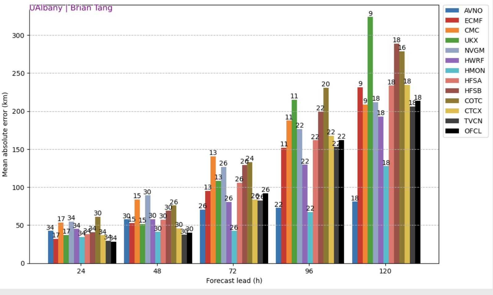
The model forecasts are better than the official Hurricane Center forecasts….I suspect that humans are probably hedging their bets with the European Center model solution.