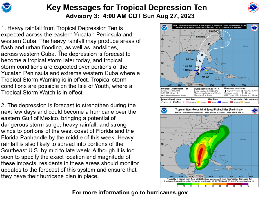
TD 10, located in the far NW Caribbean, is projected by model consensus to landfall in W FL around Wednesday. Model tracks are centered on the highly vulnerable Big Bend of FL.
Thanks much, Larry!
I'll be leaving for Detroit early Thursday for a brief visit with my almost 98 year old dad and to catch the opening University of Michigan football game and will need to cut back on posting graphics/links on several days.
These links are the best to stay on top of Idalia this week.
https://www.nhc.noaa.gov/text/refresh/MIATCDAT5+shtml/270859.shtml?
https://www.nhc.noaa.gov/graphics_at5.shtml?start#contents
Some balmy water temperatures in the GOM right now. We need around 26+ Deg. C (79+Deg. F)for hurricanes.
31 Deg. C is just under 88 Deg. F. The warmer the water, the faster the potential intensification........all other factors remaining unchanged.
https://www.ospo.noaa.gov/data/sst/contour/gulfmex.fc.gif
Below were the water temps 9 days ago, so they've apparently peaked in most places
 This is the main page for water temps everywhere:
https://www.ospo.noaa.gov/Products/ocean/sst/contour/
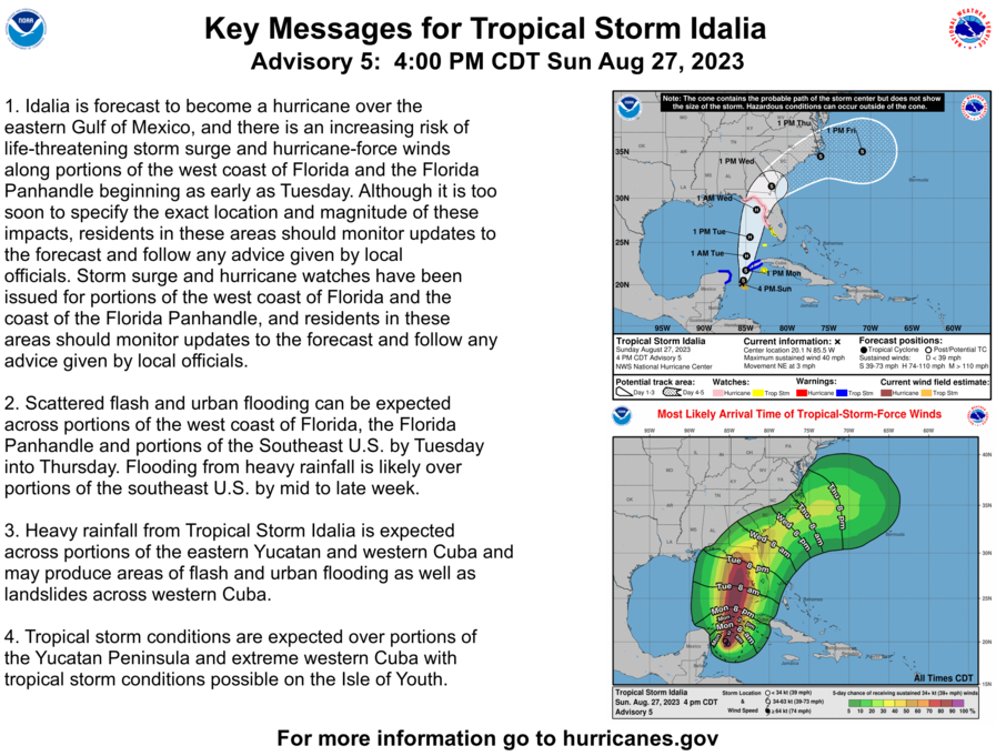
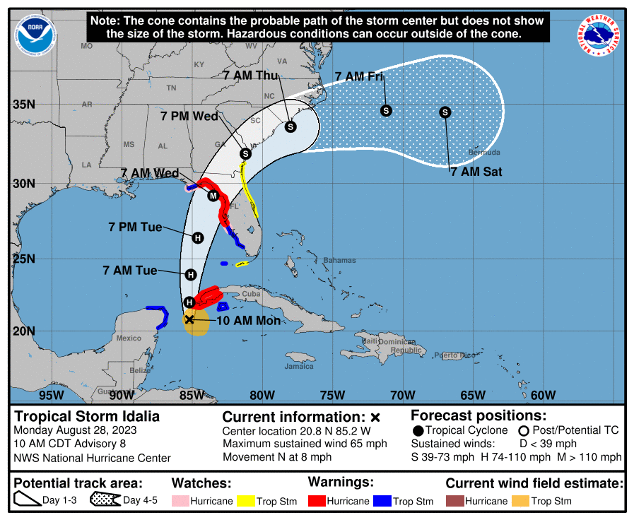
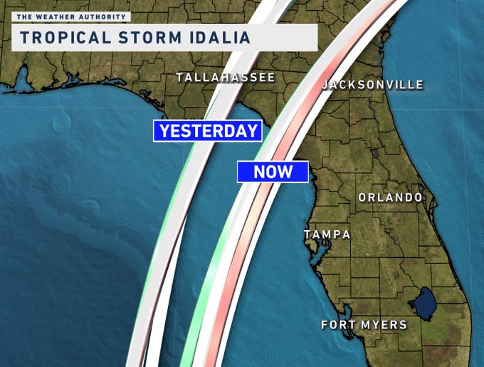
Idalia is now a Tropical Storm, soon to be hurricane.
#IDALIA UPDATE New 18z consensus models, historically better performing, have shifted 75 miles east compared to those same models 24 hours ago. Now this could still shift back west (windshield wiper effect) or it could continue east. Look for trends and consistency. I'll be… Show more
https://www.nhc.noaa.gov/graphics_at5.shtml?start#contents
https://www.nhc.noaa.gov/text/refresh/MIATCDAT5+shtml/272059.shtml?
Idalia is now forecast to become a MAJOR hurricane.
See the latest updates here. We get another one in a couple of hours.
https://www.nhc.noaa.gov/text/refresh/MIATCDAT5+shtml/280859.shtml?
Considering that so many elements are now lining up better for possible RAPID strengthening, this could potentially be a catastrophic hurricane as in REAL, unlike the over hyped threat from Hillary in the Southwest.
This is the time to hype the potential that can't be over hyped. If it fails, so be it and we all celebrate being wrong but this is the REAL deal.
Hilary's way over hyping just makes it harder to appreciate/recognize a REAL threat like this one when it emerges when the media's verbiage for both entities is compared.
If you remember, Hilary was a life threatening, unprecedented, storm of the century.
https://www.marketforum.com/forum/topic/98364/#98456
How do you top that?
The threat with Idalia is potentially 1,000+ times greater, worst case scenario.
I BELIEVE IDALIA WILL BE FURTHER SOUTH THAN THE CURRENT CONE.
HOW EXCITING.!!
Thanks, Jean!
No change to the forecast. The M below means MAJOR hurricane at 115 mph. I wasn't suggesting that this storm should be over hyped in the previous post, just that Tropical Storm Hilary, even if it overperformed, because of the cooler water and land was never capable of doing what likely Major Hurricane Idalia will do if it just meets the forecast. but the upside here, is still stronger than 115 mph.
https://www.nhc.noaa.gov/refresh/graphics_at5+shtml/150039.shtml?cone#contents
Hurricane Wind Damage Explained using VFX
https://www.youtube.com/watch?v=jSHTMhm42b4
++++++++
Eric Snodgrass
Idalia will not be a major excessive rain threat But the storm surge is likely to be the worst elememt.
7 Day Total precipitation below:
http://www.wpc.ncep.noaa.govcdx /qpf/p168i.gif?1530796126

FOLKS BETTER GET THEIR EV "GASSED" UP.
https://obxstuff.com/blogs/guides/hurricane-category-wind-chart-scale
Saffir-Simpson Hurricane Wind Scale
https://www.weather.gov/mfl/saffirsimpson
https://www.weather.gov/hgx/tropical_scale
| CATEGORY | WINDS (MPH) | DAMAGE | STORM EXAMPLE AND YEAR |
|---|---|---|---|
| 1 | 74-95 | Minimal: Damage to building structures possible, primarily to unanchored older model mobile homes. Damage to poorly constructed signs, shrubbery, and trees. Loose outdoor items become projectiles. Numerous power outages. | HUMBERTO 2007 |
| 2 | 96-110 | Widespread from very strong winds: Some roofing material, door, and window damage to buildings. Considerable damage to trees, vegetation, mobile homes, and piers. A number of high rise building glass windows dislodged to become projectiles. Widespread power outages up to several days. | IKE 2008 |
| 3 | 111-129 | Extensive from dangerous winds: Some structural damage to small residences and utility buildings with minor amount of wall failures. Mobile homes destroyed. Many trees uprooted or snapped. Power outages lasting several days or weeks. | ALICIA 1983 |
| 4 | 130-156 | Devastating from extremely dangerous winds: Some wall failures with complete house roof structure failures. Extensive damage to doors, windows, and trees. Electricity unavailable for weeks. | HARVEY 2017 |
| 5 | >156 | Catastrophic: Complete roof failure on many residences and industrial buildings. Some complete building failures with small buildings blown over or away. Power outages for weeks or months. | ANDREW 1992 |
++++++++++++++++++++++++++++++++++++++
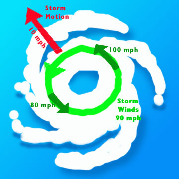
Areas to the east/northeast or right side of Ian or any hurricane(the dirty side of the hurricane) because of the counterclockwise spin, will have the speed of the storm adding to the velocity of the wind.
On the west/southwest/left side of Ian or any hurricane, the opposite occurs. Winds will be less by the amount of forward speed of the hurricane.
If Ian is traveling at 10 mph in the north direction for instance, we subtract 10 mph from the hurricane winds on its west/left side with respect to the ground/ocean. So a 90 mph wind circulation actually becomes 90- 10 = an 80 mph wind.
On the right/east side, the speed ADDS 10 mph to the circulating wind speed and we get 90 +10 =100 mph.
+++++++
WHY FLORIDA'S GULF COAST IS SUSCEPTIBLE TO A HURRICANE'S STORM SURGE
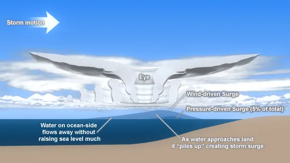
The storm motion is left to right with the circulation of the storm being counter-clockwise. Look at the water piling up at the right front quadrant of the cross-section of the hurricane.
++++++++++++++++++++++
Idalia has the potential for a storm surge of 10+ feet along the coast, that includes the Tampa Bay area. Storm surge which is focused along the coastal areas does enormous amounts of damage that is often not appreciated.
https://experience.arcgis.com/experience/203f772571cb48b1b8b50fdcc3272e2c/page/Category-3/
This national depiction of storm surge flooding vulnerability helps people living in hurricane-prone coastal areas. These maps make it clear that storm surge is not just a beachfront problem, with the risk of storm surge extending many miles
Last forecast upped the peak sustained wind to 125 mph just before landfall On Wednesday.
https://www.nhc.noaa.gov/graphics_at5.shtml?start#contents
https://www.nhc.noaa.gov/text/refresh/MIATCDAT5+shtml/290859.shtml?
Idalia is now a hurricane at 75 mph.
The next 24 hours should feature rapid strengthening. It's very challenging under optimal conditions like this to accurately predict that it will be up to 120 mph in just 24 hours as the forecast indicates. It's conceivable that it could be 140+ mph.
Added to this is the fact that Idalia is accelerating its forward speed. What ever that speed is, will ADD to the speed of the winds circulating around THE RIGHT SIDE of Idalia.
120 mph winds circulating around the hurricane become 140 mph on the right side if the hurricane it moving at 20 mph. On the left side, the forward speed takes away from the wind at the surface. So just 100 mph.
With this trajectory, when the center of Idalia hits the West Coast of Florida, the locations just south of landfall in the eye wall will have the extra 20 mph added to winds. The storm surge will also be maximized, probably greater than 10 feet. This is often the greatest threat on the coast and inland for a short distance.
Places just north of the center of this fast moving hurricane will see winds reduced by around 20 mph. The difference on either side of the hurricane is 40 mph!
Please scroll up for previous posts
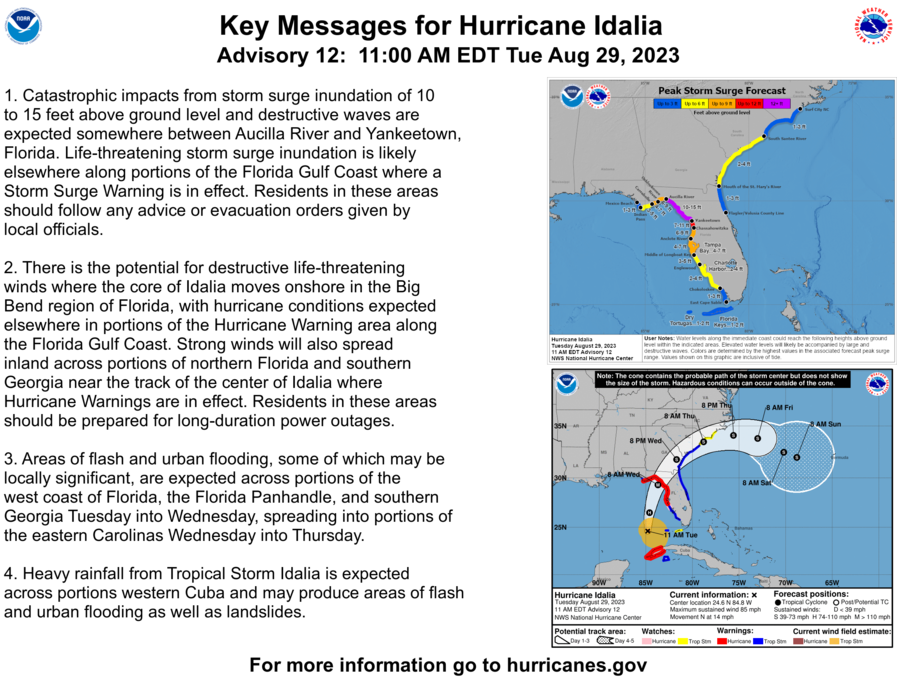
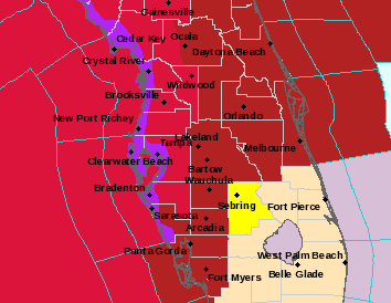
NHC just updated. Not much change except the mention of 10-15 feet for storm surge instead of 10-12 feet.
This is the biggest deal with the storm. The purple area on the top map below is now 10-15 feet of storm surge. As explained in the previous post, the parts of the purple area to the right/south of the storms center is where they will have the potential 15 feet of storm surge if the hurricane exceeds expected strength. To the left/north of the storms center will not be as bad.
More elaboration below.
++++++++++++++++++++++++
Elaboration
The good news is that this hurricane will likely be hitting far enough north of Tampa Bay and moving fast enough so that it doesn't cause a disaster in Tampa Bay. However.........
1. Storms approaching at a 90 degree angle/perpendicular create the greatest storm surges. A north/south coastline and east/west moving hurricane or east/west coastline and north moving hurricane are the worst. Idalia is hitting at a slightly oblique angle(not 90 degrees) which will blunt a bit of this but there is still plenty of perpendicular type forcing with the coastline curving to the west and the hurricane curving to the east at that location, tending to INCREASE the perpendicular component. See the map below.
2. Faster moving storms like this can often have greater storm surges to the right of the center. This is because the forward speed of the hurricane ADDS to wind on the right side which is pushing the water, which bulges up and moves with the right side and the counterclockwise winds forcing the water at the surface.
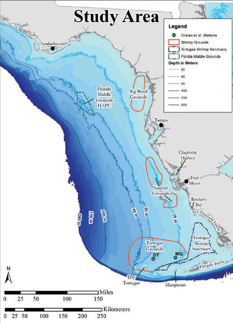
3. There's also an element related to the depth of the sea. The more shallow the water is along the coast, the greater the storm surge will likely be. This is the first time that I've studied the coastline depths but it looks like the water depth is pretty shallow in the area where Idalia will hit.
Below is going to be the area which could see the 15 foot storm surge. It will be just south of where the center makes landfall. This is entirely NORTH of Tampa Bay.
https://www.nhc.noaa.gov/refresh/graphics_at5+shtml/152743.shtml?inundation#contents
+++++++++++++++++++
++++++++++++++++++++
https://scied.ucar.edu/learning-zone/storms/what-causes-storm-surge
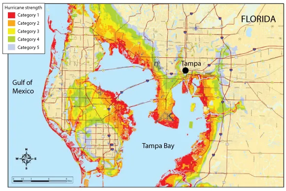
Idalia will likely be hitting NORTH of the area depicted on this map, so Tampa Bay should dodge a bullet!
This will also be a factor. Again, Idalia's center and eye wall will hit well NORTH of Tampa on Wednesday morning but I'm just using this for tides in the area tomorrow. The worst time for the storm to hit would be close to 2pm which is high tide. If it hits shortly after 8am, that will help reduce the amount of water coming in.
Tampa Bay Tide Times, Florida
https://www.tidetime.org/north-america/united-states/tampa.htm
| Tue, 29th | Wed, 30th | t | rd | |||
|---|---|---|---|---|---|---|
|
|
Thanks, Jean!
This was the last update. The forecasts the last day have continued to shift the track farther WEST/to the left and did so again. Don't let the lower intensity on their forecast fool you. It's only because the highEST intensity occurs between the 12 and 24 hour period.......just after 12 hours, when it could add an additional 15 mph to its circulation just before hitting land.
The water in this location is pretty shallow, so the storm surge is likely to be higher than most similar storms where the ocean depth is greater close to the shore.
https://www.nhc.noaa.gov/text/refresh/MIATCDAT5+shtml/290859.shtml?
POWER OUTAGE MAP
THANKS, MIKE......AND... IF IT'S STILL GOT 'NUFF SPIN ONCE IT CROSSES LAND & GETS BACK OVER THE OCEAN... WHAT ARE THE CHANCES OF IT COMIN' BACK TO THE EAST COAST OF FL.?
Chances are extremely low that if the remnants came back, they would be anything but clouds and showers.
A couple of outlier, ensemble solutions show it strengthening on a return trip so it can't be entirely ruled out but its not very likely.
The MSM is going more insane with time about any extreme weather event, blaming a 1 deg. C warming for EVERYTHING!
https://www.axios.com/2023/08/29/hurricane-idalia-unique-florida-threat
++++++++++++++
All the reporters go to every hot place and every severe storm and report it around the clock as being caused by the climate crisis as if natural variation doesn't exist anymore and ignore the hottest decade ever in the US, the 1930's.
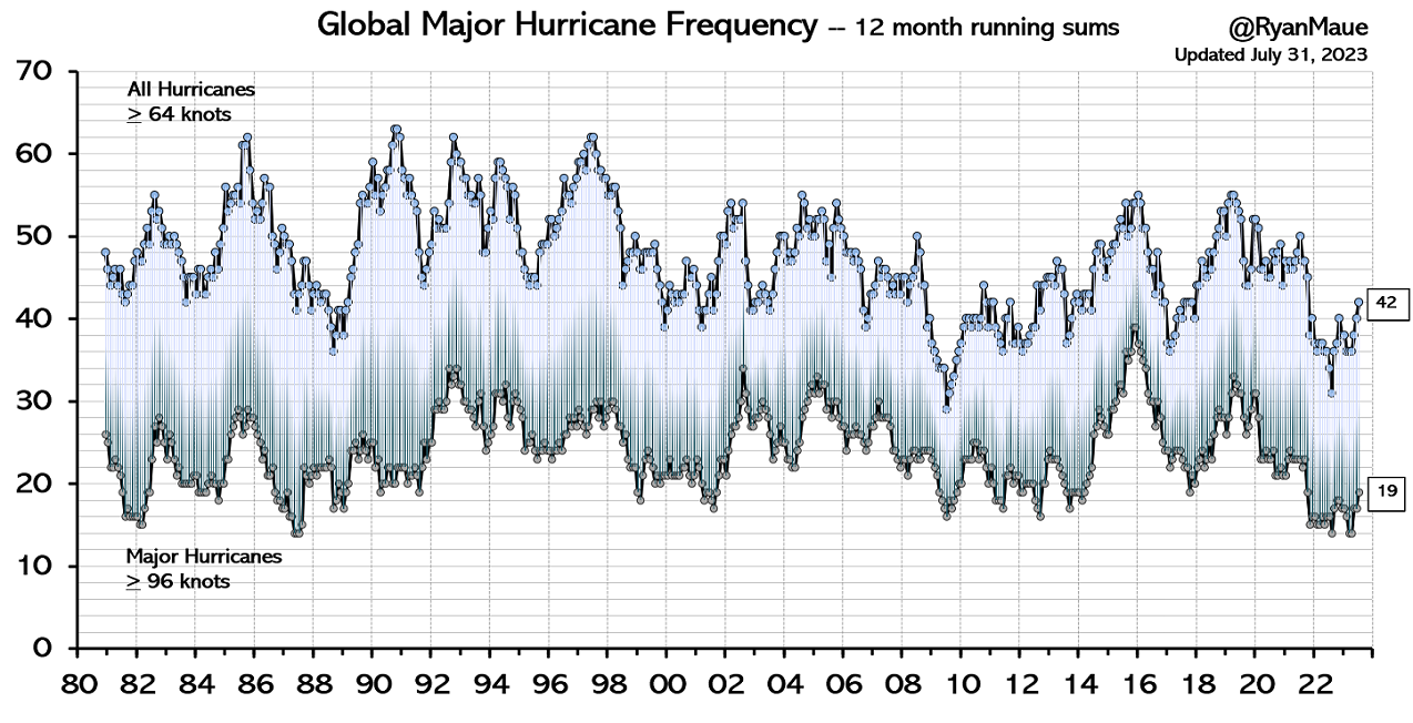
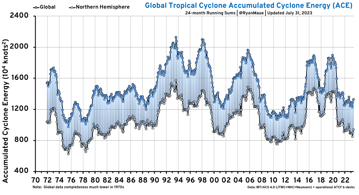
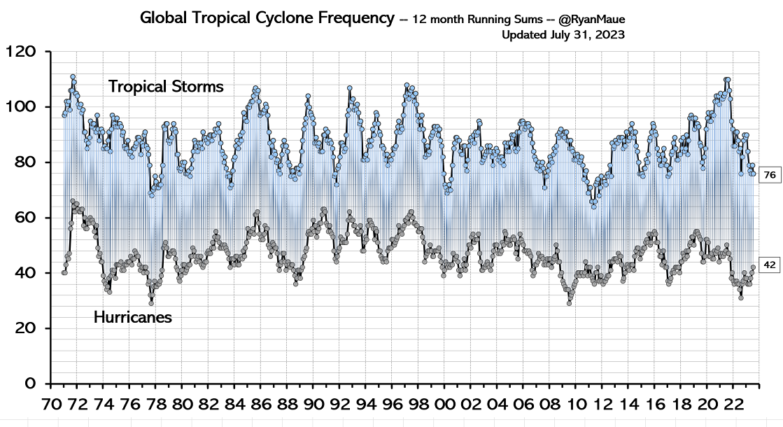
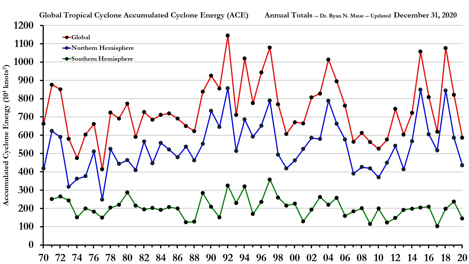
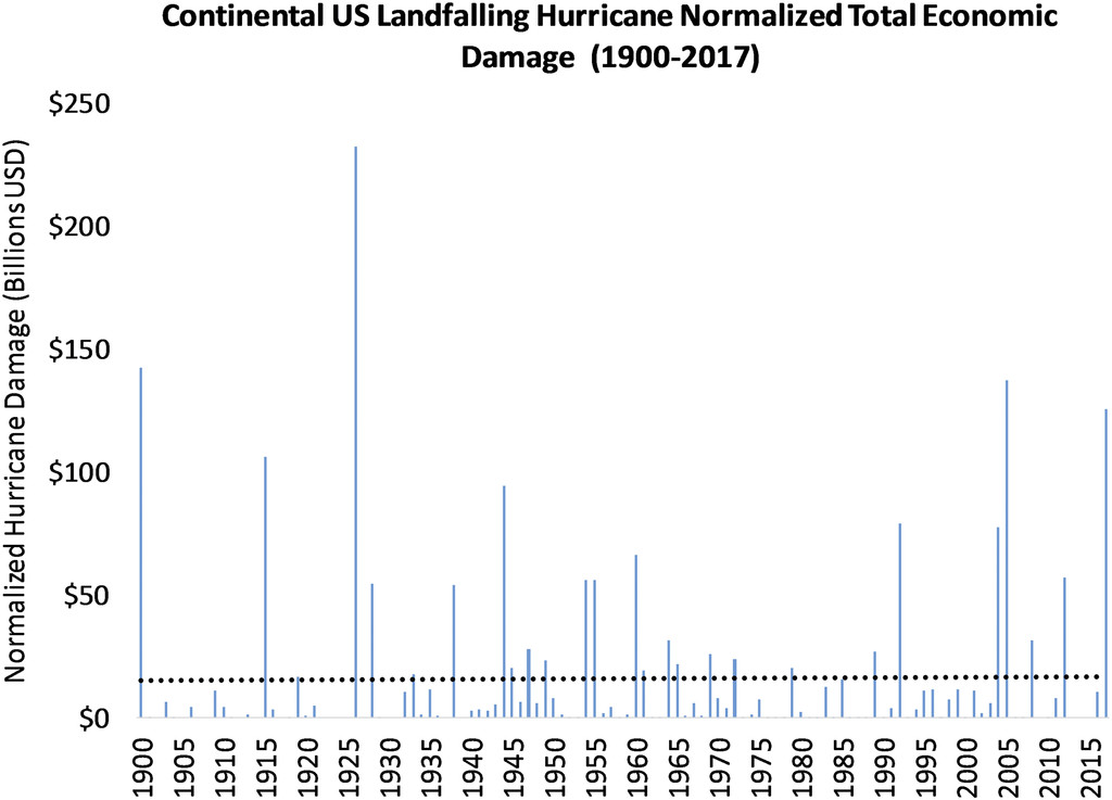
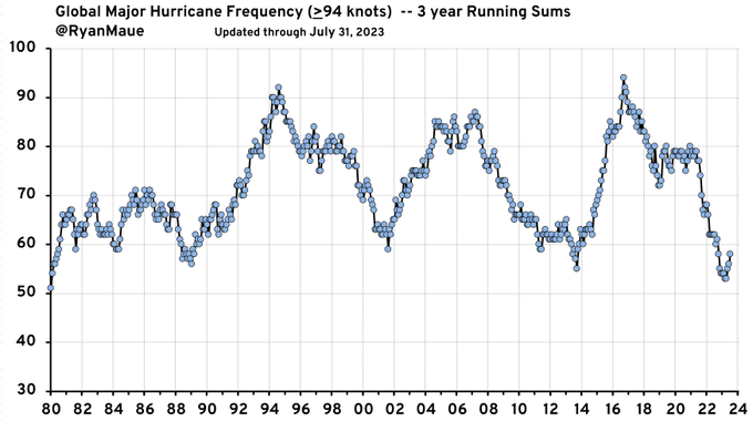
And ignore the fact that hurricanes, including MAJOR hurricanes and tropical storms have NOT increased during climate change.
You would be shocked to know that because I just looked at 25 articles today that said the complete opposite. They are WRONG and they don't show the data.......only using scary, sensationalized WORDS. See the actual data below.
Note that this data started in the satellite era.
Before then, we had tropical storms that went undetected and storms that strengthened to hurricanes that we didn't know about.
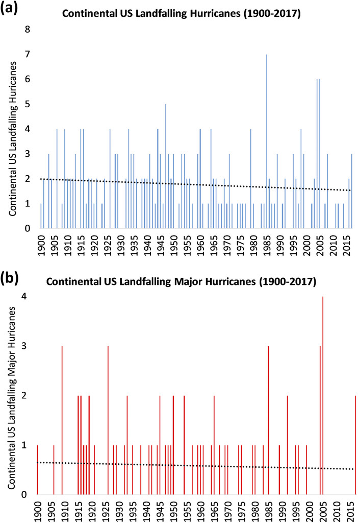
But when comparing landfalling hurricanes, back before the satellite era, its the same story. NO INCREASE.
https://www.marketforum.com/forum/topic/97993/#97994
https://www.marketforum.com/forum/topic/97993/#97995
https://climatlas.com/tropical/
++++++++++++++++
https://journals.ametsoc.org/view/journals/bams/99/7/bams-d-17-0184.1.xml
Is the warmer water in the GOM helping to make Idalia stronger?
Absolutely, yes but other factors related to climate change are having the OPPOSITE impact on OVERALL hurricanes(the meridional temp gradient is weaker-so less need for the planet to try to redistribute heat/exhaust heat in the lower latitudes when the higher latitudes are experiencing the most (beneficial) warming because of climate change). Climate change results in a more equal distribution/balance of the heat on the planet to offset the impact of the greatly unequal heating from the sun.
The only time we see graphs with authentic data on hurricanes like this above are from sources that immediately get called "deniers" for doing it.
The data is not manipulated. The graphs are all honest.wwgraphs. They all come from real, measured empirical data that represents what really happened to the best of modern science's ability to measure it.
The graph/pictures are worth a thousands words and in this case, the words contradicting this authentic data are coming from forked key boards (-:
Sadly, the forked keyboards have hijacked climate science for multiple agendas.
Last update shifts west a tad more and ups storm surge to possible 16 feet.
https://www.nhc.noaa.gov/graphics_at5.shtml?start#contents
The only good thing about the hurricane is that its hitting an area without much development/people:
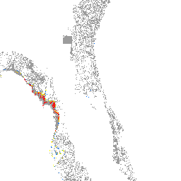
The eye is just showing up on the Tampa radar:
So many hurricane related warnings that you can just barely see the tornado watch.
I hadn't watched any tv the last few days and was just watching CNN.
They had their "climate expert" on.
He told viewers: "Idalia is all about climate change" "Climate change caused the unusually warm waters in the GOM and without those, Idalia wouldn't be there"
He went on to say "within a few years, instead of hurricanes peaking at 150 mph, like they used to, because of climate change we'll be seeing hurricanes of 190 mph"
He also mentioned water temperatures getting above 100 degrees this Summer because of climate change. This was widely,proven to be bogus. any hon3est journalist or scientist would know that.
Their next guest, called Idalia "another storm of the century" and "storms of the century have been happening too often because of climate change"
The media's increased exaggerating/sensationalizing and making stuff up about climate change is becoming more and more entertaining!
Anybody that dares tell the truth or uses authentic data/science about the weather/climate that contradicts the fake climate crisis narratives in 2023 is castigated and shunned.
I love being such a person!
Last update before landfall, they say that winds are up to 130 mph right now.
Low lying areas along the coast are being inundated By the storm surge.
https://www.spc.noaa.gov/exper/mesoanalysis/new/viewsector.php?sector=18
https://www.spc.noaa.gov/exper/mesoanalysis/new/viewsector.php?sector=18#

https://www.spc.noaa.gov/exper/mesoanalysis/new/viewsector.php?sector=18#
Jean,
You just reminded me of yet another good reason why electric cars are a horrible idea and this goal of replacing all the combustion engines cars with electric cars is retarded.
When the power goes out..........you have no way to charge your car battery.
Everybody in those large areas without power that has an electric car is stuck with whatever limited charge is left in the battery when the power went out. In some places, no power for days means no car for days. No way to get to work or to the store or to the hospital.
Like I've been harping on for years. It's based on junk science/physics, junk economics, junk environmentalism, junk functionality but great for crony capitalism and politicians/government that imposes mandates and give massive subsidies to force it on us. .......with the MSM cheerleaders providing propaganda/DISinformation about electric cars and even worse, wind turbines.
The Electric: The Valley of Death Takes Out Another EV Maker
Started by metmike - Aug. 13, 2023, 7:29 a.m
https://www.marketforum.com/forum/topic/98204/
Wind turbines
CNN trying hard to relay the "seriousness" of their hurricane coverage.
https://twitter.com/i/status/1696868056226496621
CNN went full "climate crisis" with their top climate expert Dr. Bill Weir so early in the morning with Idalia. Except, the landfall of Idalia is only strongest along coastal area since 1896 Cedar Keys hurricane (125 mph) 125-years ago, well prior to modern fossil fuel usage.
: “The cost of [using fossil fuels] is becoming bigger with every storm. Science has been warning about this for a very long time, in many ways it has been predicted. It is the speed that we’re seeing these changes that has taken most folks by surprise.”
https://twitter.com/i/status/1696855963972550963
++++++++++++++
metmike: Bill Weir is the same guy that earlier in the night, stated that hurricanes would soon be having 190 mph winds because of climate change.
https://www.marketforum.com/forum/topic/98571/#98633
Actual authentic, empirically measured, accurate data measured with our best instruments and science that HE HAS, proving him WRONG:
https://www.marketforum.com/forum/topic/98571/#98631
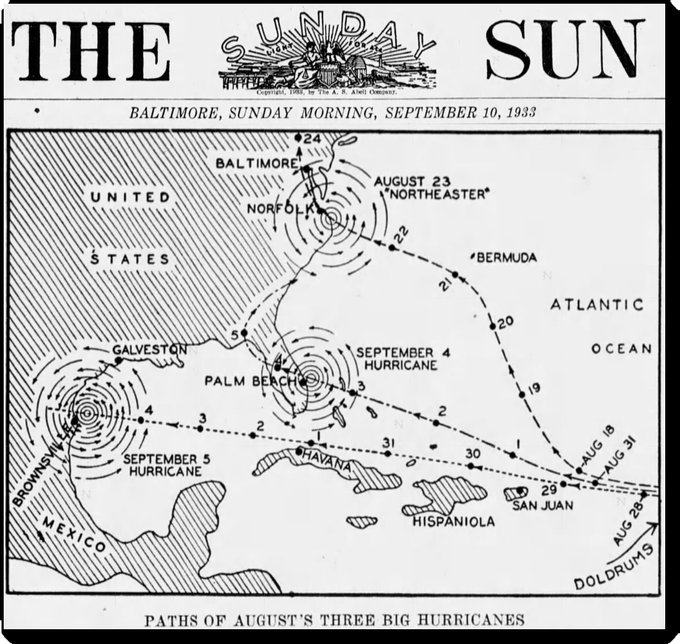
On September 4, 1933 Florida was hit by a hurricane and the following day Texas was hit by a hurricane. Two weeks earlier Virginia and Maryland were hit by a hurricane.#ClimateScam https://newspapehttp://rs.com/image/37348164
metmike: Before climate science was hijacked, extreme weather events were all from natural variation based on authentic meteorology/science.
After the hijacking of climate science, we've been told that every extreme weather event was caused by or made much worse from.............an increase of 1 Deg. C in the temperature of the planet.
Same atmosphere, same oceans, same physical laws, same meteorology, same climate except we warmed up, mostly the coldest places during the coldest times of year to reduce the temperature gradient and because of that tiny increase in temperature..........we are supposed to pretend that its the only thing that matters and is causing all the extreme weather that used to be from natural variation??
Never any mention of the benefits that are MUCH greater than the negatives.
+++++++++++++++++
It really boils down to this, once again(Cliff Mass can be counted on as an elite source for using objective, authentic science)
https://cliffmass.blogspot.com/2016/03/the-golden-rule-of-climate-extremes.html
The GoldenRule
Considering the substantial confusion in the media about this critical issue, let me provide the GOLDENRULE OF CLIMATE EXTREMES. Here it is:
The more extreme a climate or weather record is, the greater the contribution of natural variability.
Or to put it a different way, the larger or more unusual an extreme, the higher proportion of the extreme is due to natural variability.
We're grateful that FL only had 2 deaths!
About a week after the first death was confirmed in Alachua County, the second has been confirmed in Brevard County.
+++++++++
Previous "storm of the century" a week before this one:
Hurricane Hilary 8-18-23
23 responses |
Started by metmike - Aug. 18, 2023, 3:04 p.m.