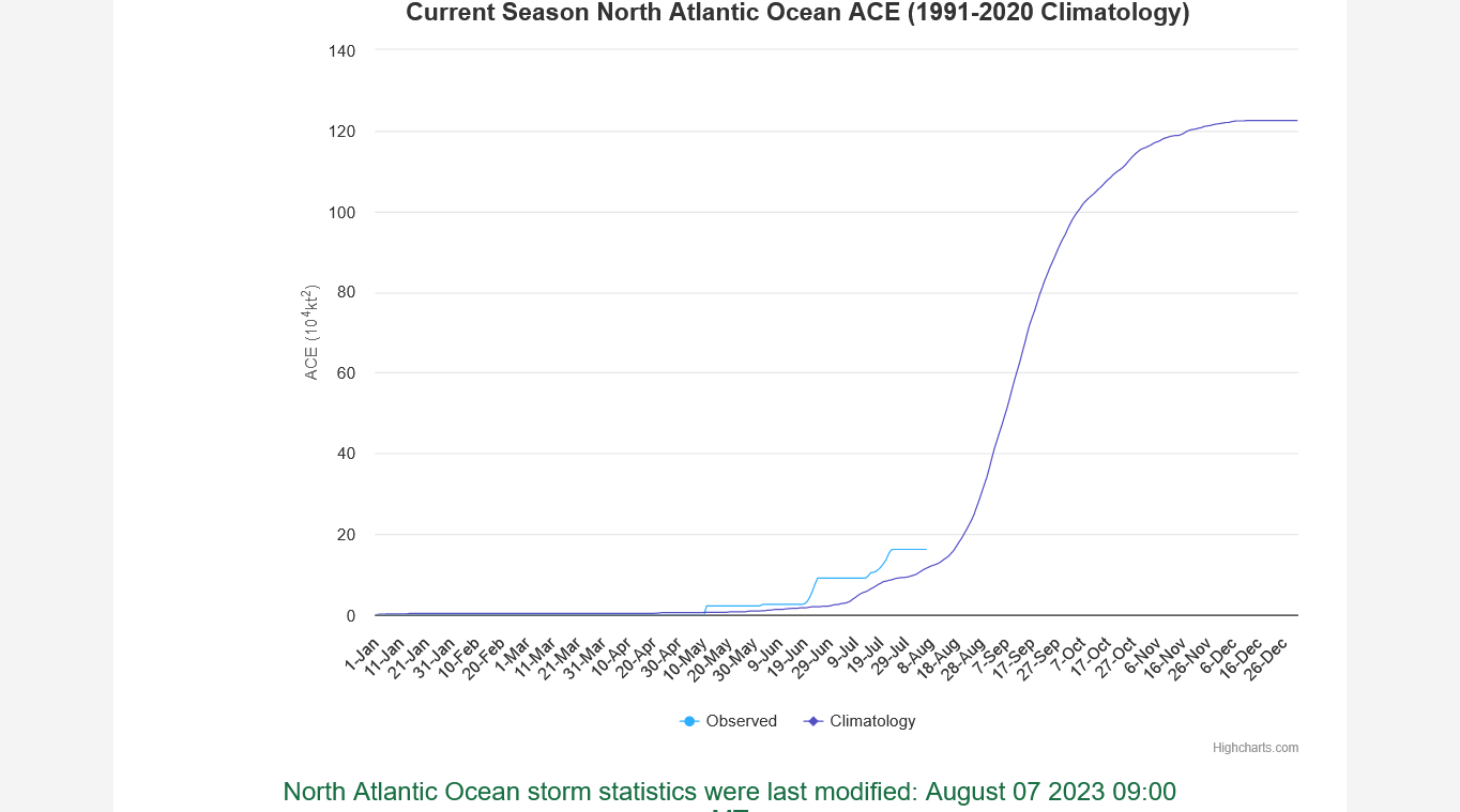
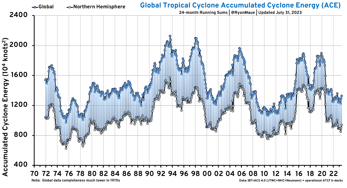
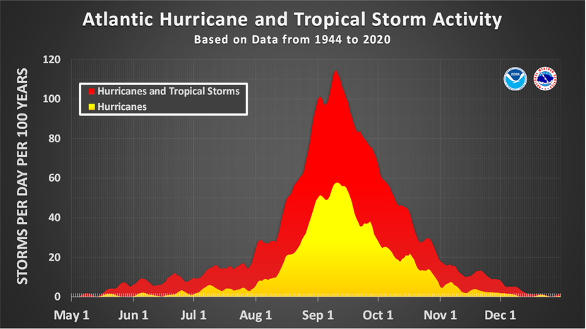
Historically, 90% of hurricanes have happened AFTER this date. Blue line below is August 7, 2023.
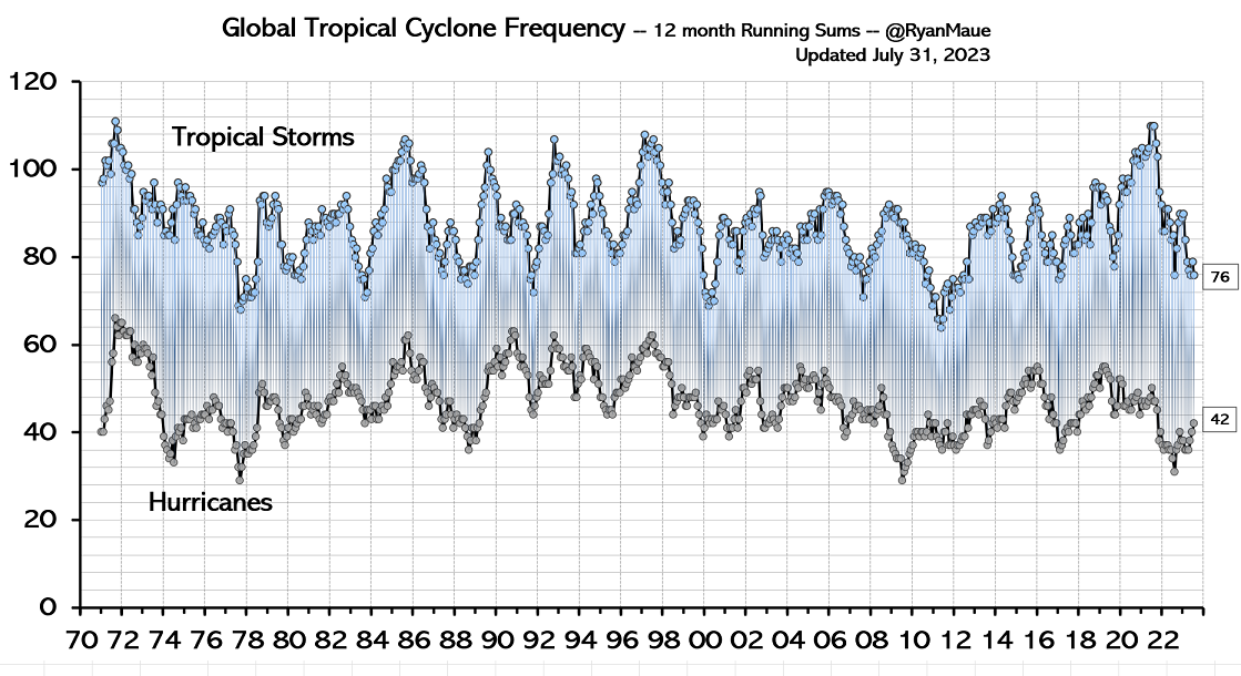
ACE=Accumulated Cyclone Energy=Tropical Storms+Hurricanes
http://tropical.atmos.colostate.edu/Realtime/index.php?loc=northatlantic
| Year | Storm# | Name | Dates TC Active | Max Wind (kts) | MSLP (mb) | Named Storm Days | Hurricane Days | Major Hurricane Days | Accumulated Cyclone Energy |
|---|---|---|---|---|---|---|---|---|---|
| 2023 | 1 | INVEST | 1/16-1/17 | 60 | 976 | 1.25 | 0.00 | 0.00 | 1.4 |
| 2023 | 2 | ARLENE | 6/2-6/3 | 35 | 998 | 0.75 | 0.00 | 0.00 | 0.4 |
| 2023 | 3 | BRET | 6/19-6/24 | 60 | 996 | 5.25 | 0.00 | 0.00 | 4.6 |
| 2023 | 4 | CINDY | 6/23-6/26 | 50 | 1001 | 3.25 | 0.00 | 0.00 | 2.5 |
| 2023 | 5 | DON | 7/14-7/24 | 65 | 988 | 9.00 | 0.50 | 0.00 | 7.2 |
+++++++++++++
https://climatlas.com/tropical/
| Basin | Current YTD | Normal YTD | % of Normal YTD | Yearly Climo* | 2021** |
|---|---|---|---|---|---|
| Northern Hemisphere | 239.6150 | 153 | 156% | 575 | 489 |
| Western N Pacific | 126.04 | 86 | 146% | 298 | 223 |
| Eastern + Cent N Pac | 52.8525 | 49 | 107% | 132 | 96 |
| North Atlantic | 16.9025 | 10 | 169% | 122 | 147 |
| North Indian | 43.82 | 7 | 626% | 23 | 23 |
| Southern Hemisphere | 243.5 x | 207 | 118% | 205 | 205 |
| Global | 435.512 | 325 | 134% |
+++++++++++++++++++++++++
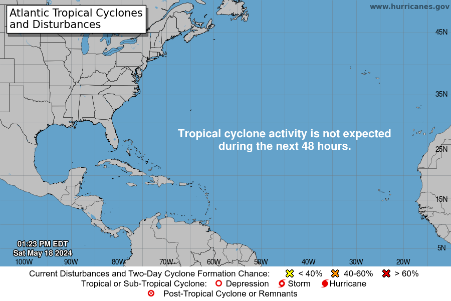
Nothing is brewing early this week:
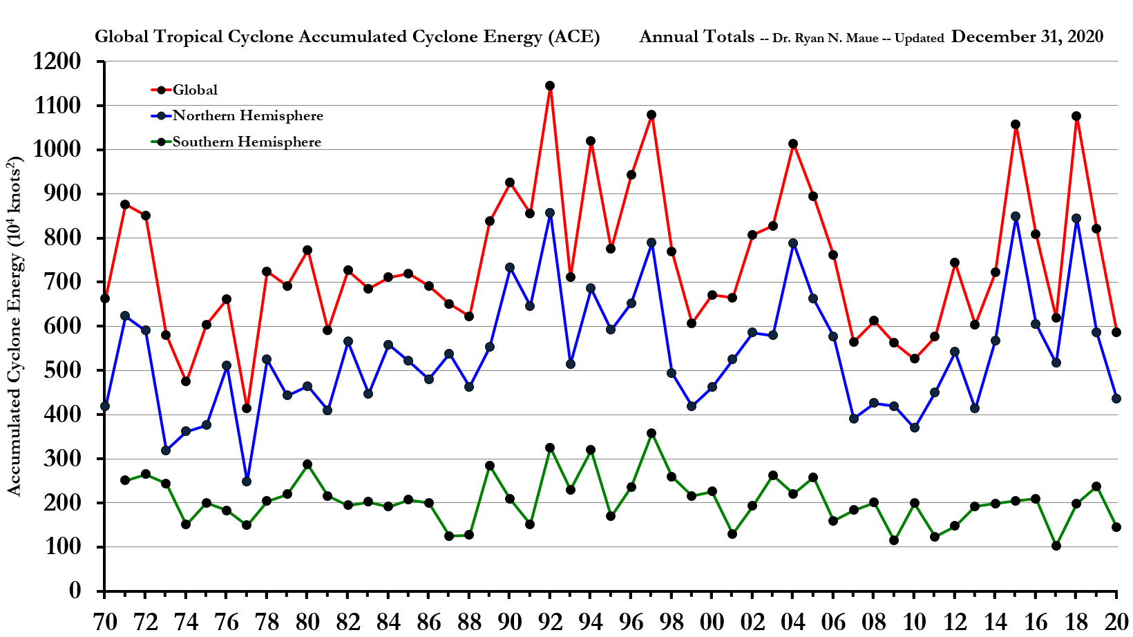
We should keep in mind that prior to the 1970's, there was alot of TS and Hurricane activity that went undetected. Before Hurricane Hunters in the 1940's, it was even more than that.
https://en.wikipedia.org/wiki/Accumulated_cyclone_energy
Accumulated cyclone energy (ACE) is a metric used by various agencies to express the energy released by a tropical cyclone during its lifetime. It is calculated by summing the square of a tropical cyclone's maximum sustained winds, measured every six hours. The resulting total can be divided by 10,000 to make it more manageable, or added to other totals in order to work out a total for a particular group of storms.
The calculation was originally created by William Gray and his associates at Colorado State University as the Hurricane Destruction Potential index, which took the square of each hurricane's maximum sustained winds above 65 kn (120 km/h; 75 mph) every six hours. This index was adjusted by the United States National Oceanic and Atmospheric Administration in 2000 to include all tropical cyclones, with winds above 35 kn (65 km/h; 40 mph) and renamed accumulated cyclone energy. The index has since been used by various other agencies to calculate a storm's accumulated cyclone energy, including the Australian Bureau of Meteorology as well as the India Meteorological Department.
Again, before the 1970's, we didn't have accurate data.
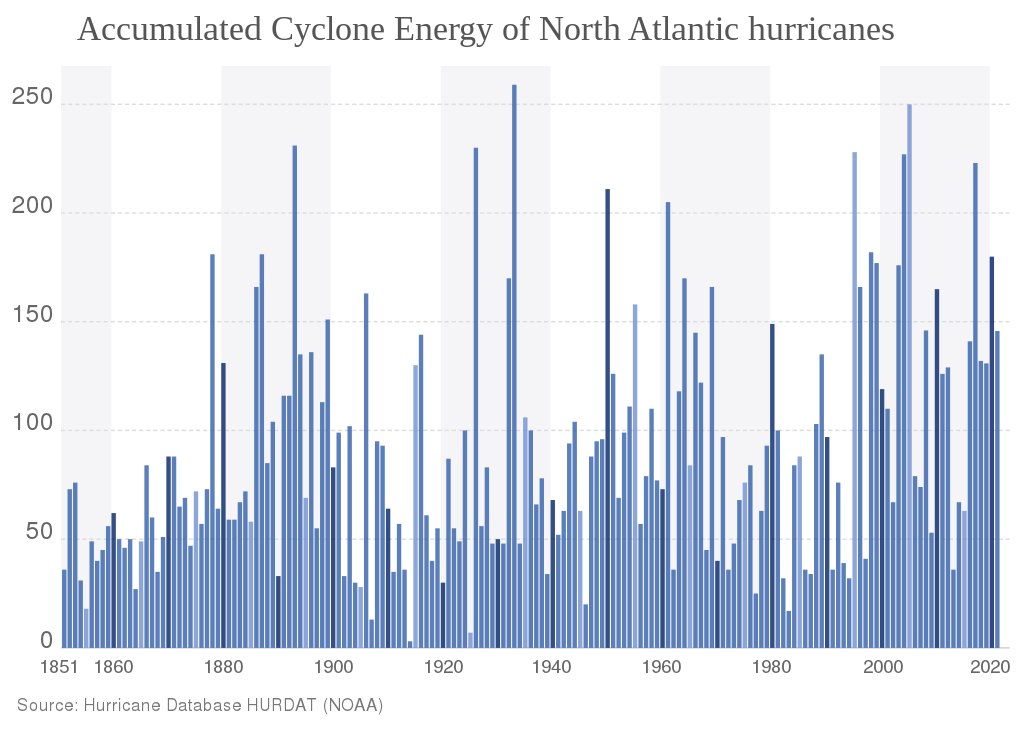
Climate change/global warming is supposed to be increasing major hurricanes based on model forecasts. You can see below that this hasn't happened. This is the defining empirical data below. It trumps models. It trumps words used to exaggerate and sensationalize. It trumps cherry picking.
Honestly, I was expecting the warmer waters to increase major hurricanes. Clearly, there is something MORE important that's suppressing that and I'm having to adjust that opinion down based on the compelling empirical data/observations from many decades of global warming in our oceans which trumps everything.
https://climatlas.com/tropical/
I flew into Hurricane Gloria in September, 1985.
https://www.marketforum.com/forum/topic/96713/#96877
https://en.wikipedia.org/wiki/Hurricane_hunters
Hurricane hunters, typhoon hunters, or cyclone hunters are aircrews that fly into tropical cyclones to gather weather data. In the United States, the organizations that fly these missions are the United States Air Force Reserve's 53rd Weather Reconnaissance Squadron and the National Oceanic and Atmospheric Administration's Hurricane Hunters. Such missions have also been flown by Navy units and other Air Force and NOAA units. Other organizations also fly these missions, such as Government Flying Service Hong Kong.
The first crewed flight into a hurricane happened in 1943 when a pilot-trainer flew into a Category 1 hurricane near Galveston, Texas on a bet.[1]
For the 40 GFS runs since July 31st, an unusually low for this model during this time of year 10% of them (four runs) have had a hurricane at any point during the 384 hours (all have been within the fantasy range) with the latest run being just the first Happy Hour run (18z) with one:
-7/31 12Z: hit SC 8/16
-8/3 6Z: hit MX/TX border 8/16
-8/6 0Z: MDR 8/18-21
-8/9 18Z: just off SC 8/25
Thanks, Larry.
I see the one from the just updated 18z GFS. I won't bother to previous runs or updates since the odds of this verifying is minuscule. Interesting hurricane season coming up though with these record warm temps in many places.
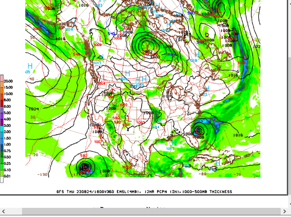
https://mag.ncep.noaa.gov/Image.php
I agree with this assessment below that there is more to hurricanes than just warm water. They redistribute heat in places that have the most to places farther north.
One reason we have NOT seen an increase in hurricanes, despite warmer oceans is that global warming is heating up the higher latitudes at double the rate of the lower latitudes, where hurricanes develop to get rid of that extra heat in order to balance the planetary heat distribution.
Climate change/global warming IS ALREADY balancing the heat distribution(coldest places warming the most) and making weather that results from extreme temperature contrasts ( strong meriodional temperature gradient) LESS extreme.
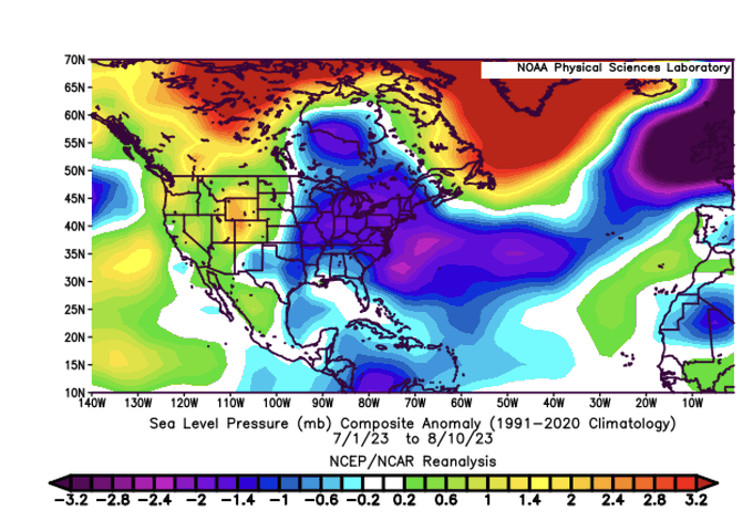
@BigJoeBastardiKiss of death for tropics so far revealed more in SLP than African dust, though that is a by product due to high pressure off NW Africa But low pressure all over the place in NAMER and NW Samer means no reason for storms as heat being taken out of tropics This is exactly why I have been trying to tell people that there are factors that LIMIT, NOT INCREASE extremes. However the bad news is this about to change and we are going to have a hurricane season. But this warm water hysteria is not all its cracked up to be. There has to be linkage and the warmth actually can be self destructive to development processes of features who sole mission besides having Big .
showing up in your town ( that has been the last couple of decades) but to redistribute heat If its already being done via distortion of pattern, then whats the need? Remember last year. its when the cooling started the hurricanes went off. You need a reason to focus heat by day 10 better, but still not ideal due to low pressures over South America ( El Nino induced)
 Mike's Weather Page@tropicalupdate
Estimated track of SAL (African dust) the next 10 days. Huge plume exiting now will trek west helping make it hard for things to develop. Currently nothing on the NHC radar. http://spaghettimodels.com
Dr. Levi Cowan@TropicalTidbits
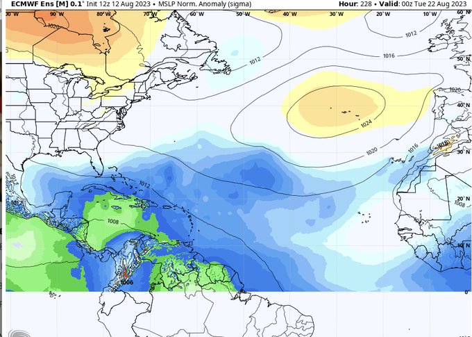
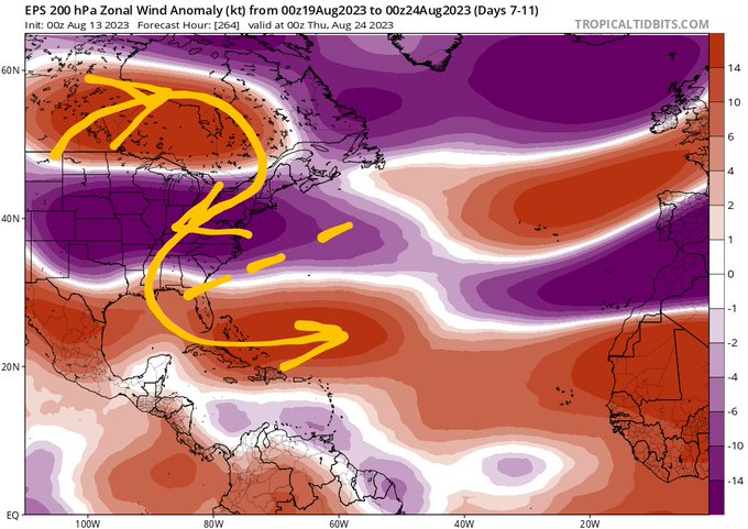
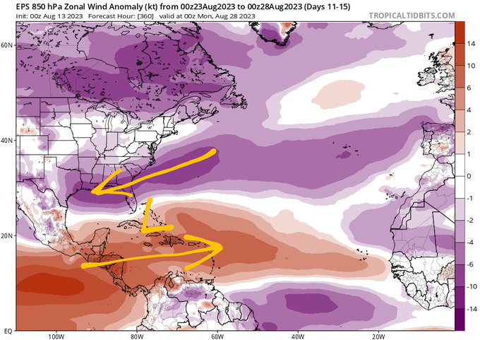
As we enter the peak weeks of the Atlantic hurricane season, it will be interesting to see where genesis events are produced. Sometimes, El Nino's suppressive influence on the Caribbean leads to a northward shift in the favorable zone. In a year when the Gulf of Mexico + west Atlantic warm pool is much warmer than normal, patterns such as this one in Week 2 ensemble forecasts can increase risks for genesis close to North America. Strong anticyclonic wave breaking at 200mb can lead to low to mid-level vorticity perturbations (such as from weak frontal boundaries or cutoff lows) being injected south of 30N, where warm water and deep moisture can lead to so-called "homegrown" TC genesis. Sometimes African easterly waves arrive from the east as an additional source of vorticity and moisture. The plots of 200mb and 850mb zonal wind anomaly from the ECMWF ensemble below show an overlap of anticyclonic wave breaking over anomalous vorticity at the surface across the western Atlantic and Gulf of Mexico, which will be something to keep an eye on in late August.
Likelihood of greater activity rises due to record-warm sea surface temperatures
")
By: Associated Press//August 14, 2023
https://journalrecord.com/2023/08/14/noaa-doubles-chances-for-nasty-atlantic-hurricane-season
++++++++++++++++
Stating that they doubled the chances for a nasty season is extremely misleading.
All they did was increase their hurricane forecast by +1 to +2 up to 6-11 from 5-9.
And major hurricanes by +1 up to 2 to 5.
8/18/23 like night and day vs 8/18/22 in MDR:
8/18/22 2AM EDT TWO:
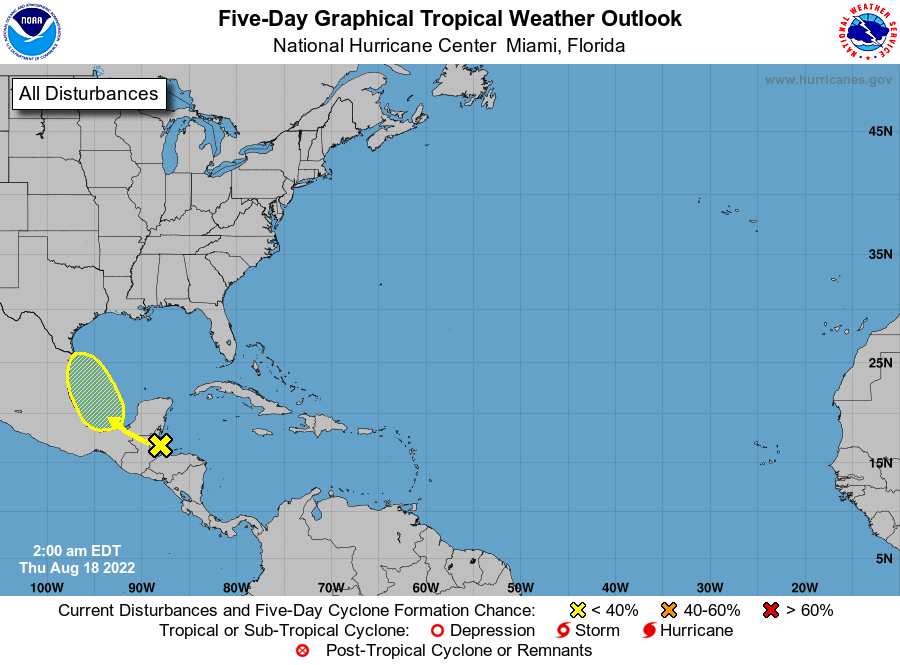
8/18/23 2AM EDT TWO:
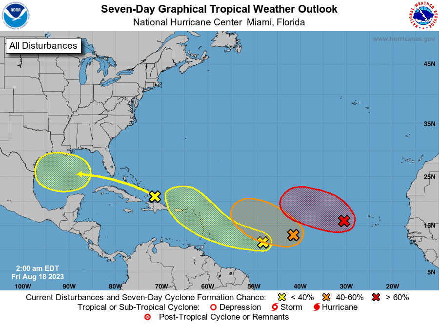
Larry,
I don't ever remember a change that great in such a short period. Thanks!
Looks like the hurricane season is about to ramp up, right on schedule based on historical tendencies.
This particular one, has received the most attention by far to date because of the record warm ocean temperatures/marine heat waves.
I know that you, like me are always fascinated with the mind boggling complexity and power of natural phenomena in the atmosphere/oceans and hurricanes represent the most powerful of the powerful.
Great challenges in tracking them that help us to appreciate their enormous power and the incredible abilities of humans to develop technology to measure everything about them, analyze and use it.
You and I live in the best time so far in human history in this respect.
100 years ago, for instance, who could have imagined what you just posted?
Information on hurricanes back then all came AFTER they had developed and mostly from land based observations. Ships in the ocean back then would go in the opposite direction of a hurricane or be lost at sea.
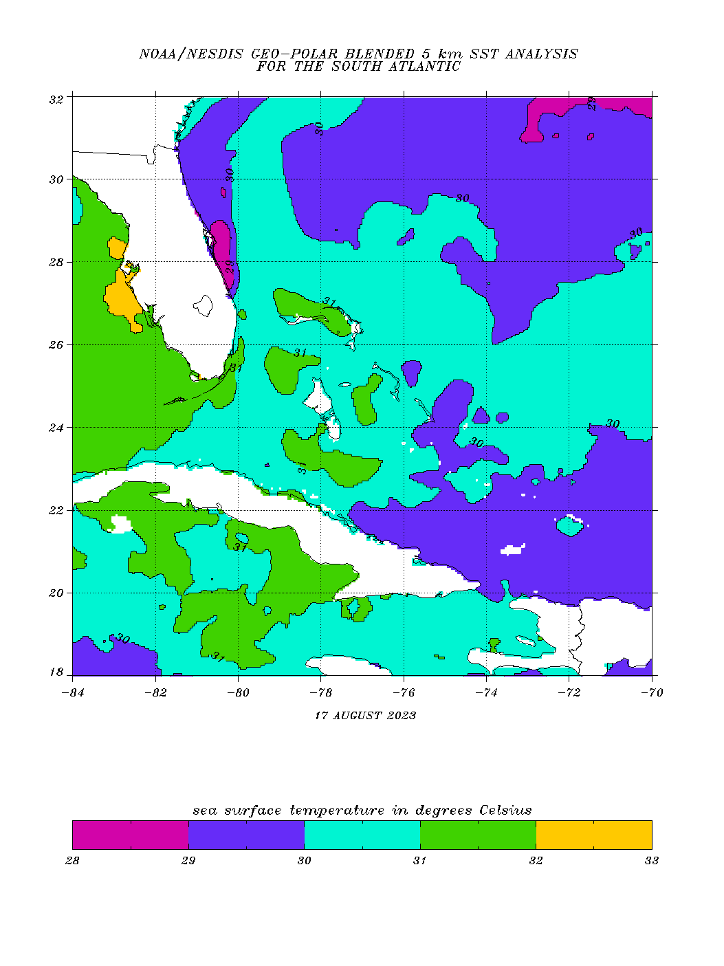
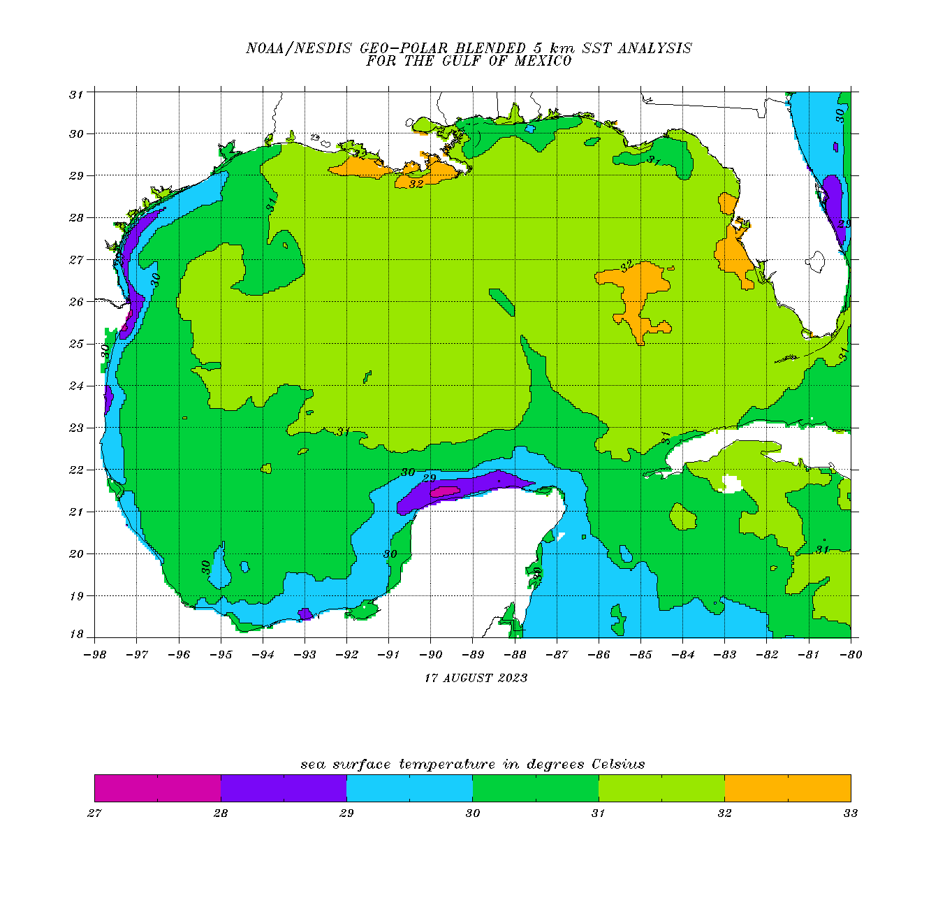
Here are the extremely warm ocean temperatures right now.
We look for 80+ Deg. F or almost 27+ Deg. C as being favorable for tropical storms/hurricanes. Generally speaking, all things being equal(which they aren't) the warmer the water to more favorable it is for tropical development.
When other conditions are optimal and we already have a tropical storm/hurricane, the warmer the water is, the more explosive the growth will likely be if its still strengthening(hasn't maxed out).
Most of the GOM on the 2nd map is at least 31 Deg. C which is almost 88 Deg. F. That's extremely warm. Up around 90 with that yellow shade (32 Deg. C).
Main page: https://www.ospo.noaa.gov/Products/ocean/sst/contour/
https://www.ospo.noaa.gov/data/sst/contour/satlanti.fc.gif
The purple shade below might be misleading. At 29 Deg. C it's 2+ Deg WARMER than what a tropical entity/storm/hurricane will use to strenthen. The yellow, 32 degree water is 5 Deg. C warmer than needed which is almost 10 Deg F warmer than the minimal temperature.
Again, that's a huge part of the focus on these record warm temperatures. Damage to the coral reefs in FL is another important discussion related to this.
Things continue to pick up in the very warm Atlantic as we head into the prime time for hurricanes.
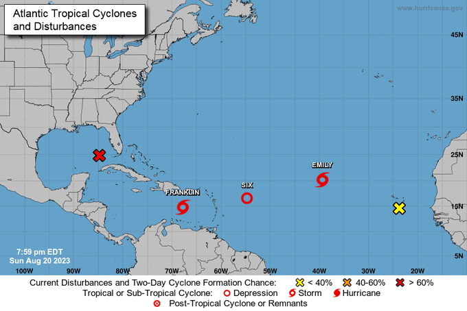
TD Gert will quickly fizzle out.
|
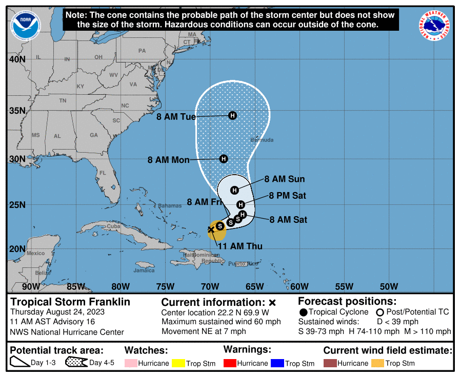
TS Franklin may become a hurricane but is no threat to the U.S.
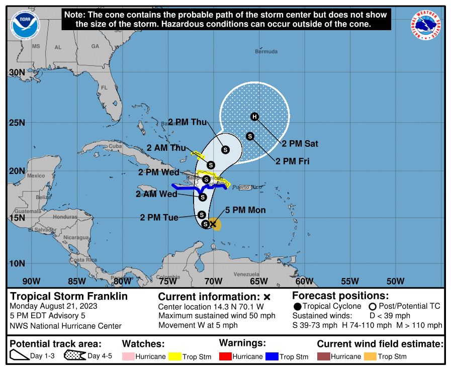
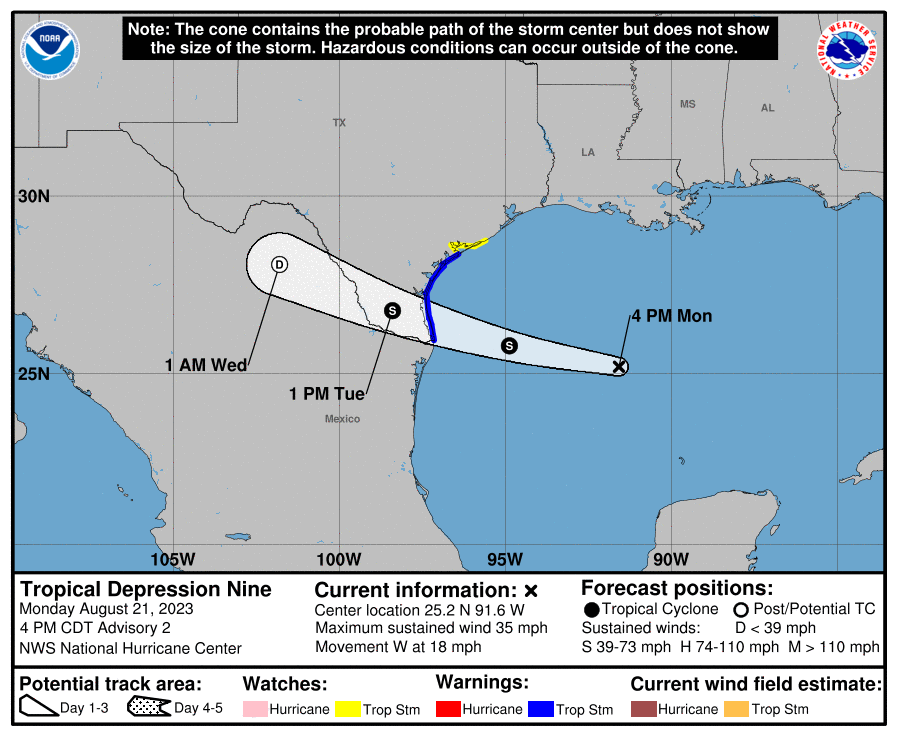
TD #9 will likely become the H named storm shortly, Harold but not get much stronger than a tropical storm.
These names are all repeated every 6 years, unless one of them becomes very significant. At that point, the name is retired and replaced with a new name with the same letter that goes on the list which will come up 6 years later and repeat every 6 years, unless the storm is noteworthy.
So the first named storms in 2029 will be Arlene, Bret, Cindy, Don and Emily, just like they were in 2023.
Atlantic Pronunciation Guide (PDF)
| 2023 | 2024 | 2025 | 2026 | 2027 | 2028 |
|---|---|---|---|---|---|
| Arlene Bret Cindy Don Emily Franklin Gert Harold Idalia Jose Katia Lee Margot Nigel Ophelia Philippe Rina Sean Tammy Vince Whitney | Alberto Beryl Chris Debby Ernesto Francine Gordon Helene Isaac Joyce Kirk Leslie Milton Nadine Oscar Patty Rafael Sara Tony Valerie William | Andrea Barry Chantal Dexter Erin Fernand Gabrielle Humberto Imelda Jerry Karen Lorenzo Melissa Nestor Olga Pablo Rebekah Sebastien Tanya Van Wendy | Arthur Bertha Cristobal Dolly Edouard Fay Gonzalo Hanna Isaias Josephine Kyle Leah Marco Nana Omar Paulette Rene Sally Teddy Vicky Wilfred | Ana Bill Claudette Danny Elsa Fred Grace Henri Imani Julian Kate Larry Mindy Nicholas Odette Peter Rose Sam Teresa Victor Wanda | Alex Bonnie Colin Danielle Earl Farrah Gaston Hermine Idris Julia Karl Lisa Martin Nicole Owen Paula Richard Shary Tobias Virginie Walter |
At this point, we're a bit ahead of average in the Atlantic tropics. This makes sense with the record warm temps, even with the strengthening El Nino that often causes wind sheer in the Atlantic which can tear apart tropical systems.
https://www.nhc.noaa.gov/climo/
| Number | Named systems | Hurricanes | Major Hurricanes |
|---|---|---|---|
| 1 | Jun 20 | Aug 11 | Sep 1 |
| 2 | Jul 17 | Aug 26 | Sep 19 |
| 3 | Aug 3 | Sep 7 | Oct 28 |
| 4 | Aug 15 | Sep 16 | - |
| 5 | Aug 22 | Sep 28 | - |
| 6 | Aug 29 | Oct 15 | - |
| 7 | Sep 3 | Nov 15 | - |
| 8 | Sep 9 | - | - |
| 9 | Sep 16 | - | - |
| 10 | Sep 22 | - | - |
| 11 | Oct 2 | - | - |
| 12 | Oct 11 | - | - |
| 13 | Oct 25 | - | - |
| 14 | Nov 19 |
For only the third time on record (since 1851), 3 Atlantic tropical cyclones formed over 24 short hours (TD6, Emily, Franklin). The historic tropical cyclone outbreak this weekend was matched only by August 22, 1995, and August 15, 1893. #hurricanes
Keep in mind that before the satellite era, circa 1970's, this would be impossible to detect most of the time.
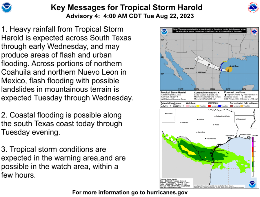
As expected, Harold was named and now goes a bit farther south than the path indicated yesterday.
https://www.nhc.noaa.gov/graphics_at4.shtml?start#contents
Harol
+++++++++++++++++++++
Harold just made landfall a short time ago as a minimal Tropical Storm.
https://www.nhc.noaa.gov/text/refresh/MIATCDAT4+shtml/221450.shtml?
Thanks, Jean, especially for reminding me to take a gander at the tropics this morning. I have your predictions (highest of everybody) from almost 3 months ago as the most likely to win our contest! Things usually just get going at this time of year.
Mktfrm 2023 Atlantic Hurricane Season Forecast Contest: deadline *6/4/23* https://www.marketforum.com/forum/topic/95746/
Latest from the NHC:
No MAJOR threats to the US the next week.
Franklin, below may hit major hurricane intensity in 96 hours but with no threat to land.
https://www.nhc.noaa.gov/graphics_at3.shtml?start#contents
https://www.nhc.noaa.gov/text/refresh/MIATCDAT3+shtml/241450.shtml?
For Tue/Wed of next week, FL and the SE should monitor this:
3. Northwestern Caribbean Sea:
A broad area of low pressure, originating along the East Pacific
coast of Central America, is forecast to move into northwestern
Caribbean Sea by this weekend. Some gradual development of this
system is possible thereafter into early next week, and a tropical
depression could form while it moves slowly northward, entering the
eastern Gulf of Mexico.
* Formation chance through 48 hours...low...10 percent.
* Formation chance through 7 days...medium...50 percent.
Thanks much, Larry!