
I'm doing a 2023 Atlantic hurricane season forecast. This is open only to Marketforum members. Deadline to post a prediction is 6/4/23 10:59 PM CDT/11:59 PM EDT. Edits can be done til then.
It's simple. Just provide three numbers: # of tropical storms (including subtropical storms), # of hurricanes, and # of major (category 3+) hurricanes that form through ALL of 2023. The subtropical storm that already occurred in January will count in the tropical storm tally. So, please incorporate 1/0/0 in your predictions.
Scoring: Start with 100 points. Subtract one point times how far off your # of tropical/subtropical storms ends up being, two points times how far off your hurricane # ends up being, and 4 points times how far off your # of major hurricanes ends up being.
Please make sure your 1st number is at least as high as your 2nd number and that your 2nd number is at least as high as your 3rd number. If not, your forecast will not be allowed in the contest.
Example: if the total 2023 tally were to end up at 16/10/5 and your forecast were 14/8/2, your final score would be 100 - (1 x 2) - (2 x 2) - (4 x 3) = 82.
The winner will be honored with a HUGE kudos along with a post of the week honor in early 2024 (just after the 2023 total tally can be done). Often, the NHC reanalyzes the season later and changes the official tally. Only those changes done by the NHC by 12/31/2023 will be incorporated in this contest.
**Edited for correction
My pick is 10/5/2
This is awesome Larry, especially with you picking first.
I'll have to look more to compare with some analogs before making my wild guess.
We'll add some educational links for everybody to get a better understanding of hurricanes too!
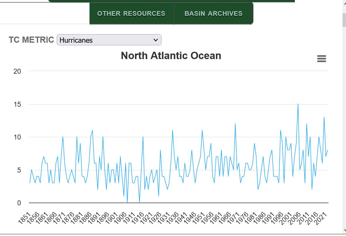
http://tropical.atmos.colostate.edu/Realtime/index.php?arch&loc=northatlantic
LOL OHHHHHHHHHHH, WHAT FUNNNNNNNNNNN!
I SHALL RETURN, WITH MY "GUT INSTINCT" PREDICTIONS ~ WEEEEEEEEE
We look forward to it Jean!
There's been quite a range in activity between the lowest and highest years. Again, keep in mind that we didn't have today's technology to observe/ accurately record tropical storms/hurricanes in the middle of the oceans until the satellite era but really after we started sending in hurricane hunter planes in the mid 1940's.
https://en.wikipedia.org/wiki/Atlantic_hurricane_season

https://en.wikipedia.org/wiki/Hurricane_hunters
Hurricane hunters, typhoon hunters, or cyclone hunters are aircrews that fly into tropical cyclones to gather weather data. In the United States, the organizations that fly these missions are the United States Air Force Reserve's 53rd Weather Reconnaissance Squadron and the National Oceanic and Atmospheric Administration's Hurricane Hunters. Such missions have also been flown by Navy units and other Air Force and NOAA units. Other organizations also fly these missions, such as Government Flying Service Hong Kong.
The first crewed flight into a hurricane happened in 1943 when a pilot-trainer flew into a Category 1 hurricane near Galveston, Texas on a bet.[1]
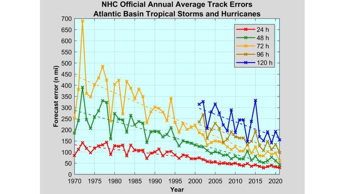
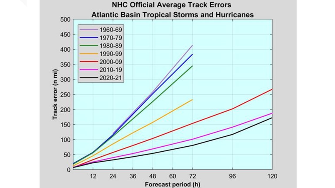
In the past, before satellites were used to find tropical storms, military aircraft flew routine weather reconnaissance tracks to detect formation of tropical cyclones. While modern satellites have improved the ability of meteorologists to detect cyclones before they form, only aircraft are able to measure the interior barometric pressure of a hurricane and provide accurate wind speed data, information needed to accurately predict hurricane development and movement.
Some awesome data/graphics displayed at this link!
https://www.nhc.noaa.gov/climo/
Previous thread on MarketForum:
2023 hurricane season prediction
16 responses |
Started by metmike - May 25, 2023, 7:10 p.m.
https://www.marketforum.com/forum/topic/95535/
ARE ANY OF THEM TO HIT LAND, OR... DOES IT MAKE ANY DIFFERENCE?
LOL I DON'T HAVE YOUR MATH CALCULATIONS FIGURED OUT, BUT... I WILL ~ ALL IN DUE TIME
Jean,
1. It doesn't matter for this contest whether or not they hit land.
2. I just reworded how the scoring works because I felt after rereading it that it wasn't worded well. Check it out again and see if it is now clear. I'm looking forward to your prediction.
https://www.nhc.noaa.gov/aboutgloss.shtml
A tropical cyclone less than 39 mph is a tropical depression
From 39-73 mph it's a tropical storm-first number in WxFollowers contest
74+ mph is a hurricane-2nd number
110+ mph is a major hurricane-3rd number
The strengthening process thru the peak will ALWAYS be over water.
Every tropical system will weaken as it's circulation encounters land. Many of them will weaken over water(encountering things like wind sheer or a cooler water temp). Some spend their entire lives over water.
To answer your question, Jean ALL Tropical Storms, Hurricanes and Major Hurricanes count...land or sea.
Thanks for the clarification, Larry!
OKAY, LARRY ~ THE "MUD" IS SETTLIN' DOWN, A LITTLE. (I COPIED YOUR FIGURES & PUT 'EM IN MY DRAFT FOLDER, FOR QUICK REFERENCING)
DEPRESSIONS DON'T COUNT... CORRECT?
THIS'LL BE FUNNNNNN
THANK YOU!
Jean, you're welcome. No, tropical depressions aren't strong enough to count for this contest.
LOL HERE'S MY 1ST #
18
I WISH THEY'D NEVER NAMED STORMS THAT AREN'T TROPICAL!
WHAT & WHEN WAS SANDY?
Jean,
great question On Superstorm Sandy!
im especially loving your enthusiasm and thirst for learning here!
interestingly Sandy was the 18th TS of the 2012 season and you’ve picked 18 as your prediction for TSs here in 2023.
I’ll send you. a couple of great reports on this because the history is extremely long but Sandy, at 1 point was the largest tropical storm or hurricane based on circulation extent of gale force winds Which were over 1,100 miles across/diameter In the northeast.
Superstorm Sandy was actually a POST tropical storm with minimal hurricane winds that stalled out in the northeast for several days as it interacted with an unusually strong/deep , early cold season -NAO trough in the Northeast.
this made it a sort of hybrid storm with tropical and extratropical characteristics, maintaining a lot of strength and drifting slowly for days Before ejecting northeast after getting picked up by the northern jet stream associated with the deep -NAO trough.
since it was clobbering the Northeast in late October, it was dubbed Frankenstorm, my favorite nick name for any storm.
It was blamed on climate change/global warming.
stalled storms are a bit more likely with climate change but the meteorology of this stall was the opposite of being caused by global warming.
Its interaction with a COLD WEATHER anomaly for so early in the season, the deep -NAO trough in the Northeast played a very strong role. An early season cold weather pattern can’t possibly be caused by global warming.
Supersorm Sandy was almost entirely caused by natural variability of the weather.
I will give it a try 12/6/2 Thank you for the post and 'competition'!!
MIKE ~ WHEN I LIVED IN W. PAM BEACH '1970 - 1978"... NO INTERNET OF COURSE ~ THE TV STATIONS WOILD GIVE OUT TRACKING MAPS. I LOVED THAT!!
WITHIN A FEW DAYS, I'D KNOW WITHIN 50 MILES OF WHERE A LANDING WOULD BE.
IT'D BE LIKE: IT'D GUIDE ME, OR I'D BE GUIDING IT. I NEVER DID FIGURE OUT WHO WAS GUIDING WHO. LOLOLOL AFTER THE 3RD OR 4TH STORM REPORT I'D CALLED INTO THE STATION WITH ~ THEY'D BE CALLIN' ME!!
PREMONITIONS, I GUESS. I'VE ALWAYS HAD THOSE, ABOUT A LOT OF STUFF. ✔
OKAY... HERE'S MY 2ND #
8
I'LL NEED THESE LAST 2 DAYS, TO STARE AT THE OCEANS!! LOL
This is just a friendly reminder that the deadline to enter is 11:59 PM EDT/10:59 PM CDT today. So far there are two complete entries (tjc and myself) and 2/3 of another entry from Jean, who is planning to complete it in time.
Remember that major kudos, an honorary post of the week in January, and bragging rights as the Marketforum 2023 Hurricane Season forecasting champ til the 2024 season are all on the line! What could be better than that?!?
**Edits of previously posted predictions are allowed til the deadline.
Thanks, Larry!
I haven't forgotten.
LOL I'M GONNA GET ME A COFFEE & PRETEND I'M SITTIN' AT THE OCEAN, OFF PALM BEACH, FL. ~ AS I GAZE AT SOME OCEAN MAPS. IT'S NOT REAL EASY TO "FEEL" THE OCEAN, WHEN YER 1,000 MILES FROM IT!
I'm bumping this purely for visibility reasons in the waning hours of the entry period. Looking forward to Jean's MH #, Mike's entry, and anyone else who may want to enter. Remember that edits of already posted numbers can be done until the deadline.
Thanks, Larry.
I've not submitted my picks yet because I wanted to review the following years with similar ENSO conditions........rapidly heading into a strong El Nino.
1957-8-3-2
1965-10-4-1
1972-7-3-0
1982-6-2-1
1991-8-4-2
1997-8-3-1
2015-11-4-2
I didn't want to bias others using their own insights either.
Also, did you know that there was an unnamed subtropical storm in January of this year that they didn't recognize until May that will be listed in their final stats for 2023?
https://www.marketforum.com/forum/reply_post/95890/
If the NHC adds this to their storm list at the end of the year, and it appears they will then I assume it will count for this contest. This will mean 1 more storm than the officially named storms.
With this additional info, others trying to fine tune might consider bumping up their number by 1 or you could set the rules to apply only to NAMED TROPICAL STORMS, so there's no confusion.
What do you think, Larry?
Thanks again for this awesome contest. I love it!!
IN LARRYS'' VERY 1ST POST: "The subtropical storm that already occurred in January will count in the tropical storm tally. So, please incorporate 1/0/0 in your predictions."
SOMETIMES. IT PAYS TO BE A SLOW READER. LOL
OKAY ~ I'M GONNA BE CONSERVATIVE IN MY FINAL NUMBER
DRUM ROLL. PLEASE ♫ ♫ ♫ ♫ ♫  ♫ ♫ ♫ ♫ ♫
#5
FULL SET OF NUMBERS ~ 18 ~ 8 ~ 5
__________________________________
GOOD LUCK TO ONE & ALL LOL
WEEEEEEEEEEEEEE STAY SAFE
CLICK BELOW
AS CLOSE AS I CAN GET TO BEIN' AT THE OCEAN
IN LARRYS'' VERY 1ST POST: "The subtropical storm that already occurred in January will count in the tropical storm tally. So, please incorporate 1/0/0 in your predictions."
Thanks much, Jean, I completely missed that!
Good luck to you. Looks like an active season will make you our champ!
I'll pick: 13/7/3
The rapidly strengthening El Nino analog year average is: 8.5/3/1 but warm Atlantic Ocean temps might cause tropical storms and hurricanes that do develop to have rapid intensification if/when they hit patches of elevated oceanic heat.
https://www.foxweather.com/learn/what-is-hurricane-rapid-intensification
YOU'RE WELCOME, MIKE
"Good luck to you. Looks like an active season will make you our champ!"
AND, AN INACTIVE SEASON, WILL MAKE ME YOUR CHUMP! LOL
WHAT FUNNNNNNNNNNN
AN INACTIVE SEASON, WILL MAKE ME YOUR CHUMP! LOL
Welcome to the world of weather forecasting, Jean!
I've been the chump a thousand times in the last 40 years!
LOLOLOL MIKE!
NOW, I'LL PROBABLY DIE BEFORE THE SEASON ENDS & I'LL NEVER KNOW IF I WOUND UP BEIN' A CHAMP OR CHUMP!! EITHER ONE IS BETTER THAN BEIN' A CHIMP, THO!
wx picks 10/5/2
12345 picks 18 for 1st number
TJC picks 12/6/2
12345 picks 2nd number 8
Mike shows info
1957-8-3-2
1965-10-4-1
1972-7-3-0
1982-6-2-1
1991-8-4-2
1997-8-3-1
2015-11-4-2
*** highest 1st number 11*** cutworm **
12345 picks 18 ~ 8 ~ 5
Mike picks 13/7/3
JMHO is mike playing Chess? taking up as much of the center of the board as he can?
1234 has all the above part
WX all the below... mikes history would seem to give wx an advantage
Cutworm has no clue therefore no pick.... just for fun
Thanks, cutworm!
You raise great points!
I think Larry and TJC have great picks but they got those numbers first and I thought that, being a contest with a clear winner, you can't have people with the same picks or that could result in a tie.
I didn't want to go lower because those are already low compared to the last 2 decades. .........even despite the El Nino. But I considered it.
Also, this required me to actually go against what one might think is my bias about the fake climate crisis........which is claiming that hurricanes are NOT more frequent and they are exaggerated.
Usually, somebody with that bias would pick the LOWEST numbers.
But my mind actually doesn't work that way. When I know that I have a bias, I will use the scientific method and try to see why I'm wrong about my views and not right in order to test the objective authenticity.
You astutely recognized that I SHOULD BE rooting for the lowest numbers, because those are the ones which would best provide evidence that we DON'T have a climate crisis.
But the objective isn't to find reasons to be right, it's to see all the reasons and consider the ones that you are wrong and give them just as much weighting, all things being equal. Then, let the data tell us what's right and what's wrong.
So that's part of my mentality.
Jean could blow us all away too. I can't tell you the number of times (thousands in 40 years) that I predicted the weather with high confidence based on all the weather models and forecasts clearly showing one thing would happen..........then, the complete opposite happened.
All the models, analogs and forecasters seem very confident that the El Nino will cause a wimpy hurricane season.
There are rock solid atmospheric principles to base that on. ......which is why Jean is by herself with those lofty numbers.
But there is enough that WE DON'T KNOW about weather/climate so that forecasts bust really badly. That applies to seasonal hurricane predictions too, although this is in a much different realm from daily weather forecasts or long range climate forecasts.
Personally, I think Larry has a MUCH better chance to win than Jean and better chance than metmike(I dialed in global warming to elevate my prediction as odd as that seems). A huge part of me wants Larry to win and not me because its evidence that NATURAL forces are determining tropical weather outcomes more than man made climate change.
LOLOL THIS IS FUNNNNNNNNN, IMO.
MY ONLY DISADVANTAGE IS ~ NOT BEING ABLE TO SIT AT THE OCEAN & "FEEL" IT. TO GET THAT "PROJECTION" FLOWING BOTH WAYS, & SO FAR AWAY, ISN'T EASY.
THEN, AGAIN... MOST FOLKS DON'T UNDERSTAND "PROJECTION" / TELEPATHY
This Hurricane Season Is About To Go Nuts…
OH, WHAT FUNNNNNN ~ I LAUGHED & LAUGHED SOME MORE LOLOLOL
https://www.marketforum.com/forum/topic/97220/#97308
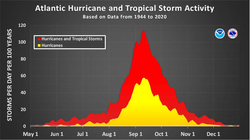
Don is the 4th storm of the traditional hurricane season.
The average 4th storm occurs on August 15th.
Thanks, cutworm!
The season is now at 5/1/0 including Don.
As of 9/23 with Philippe as a TS, this season has so far had 17 NS, 6 H, and 3 MH (including unnamed Jan STS). That means that TJC’s 12/6/2 and my 10/5/2 are eliminated. So, it is either 12345’s (Jean) 18/8/5 or MetMike’s 13/7/3 to win!
If the season were to end up at the current 17/6/3 (very highly unlikely), Mike would win by 3 with a score of 94 vs TJC’s 91, 12345’s 87, and my 87.
Edit:
- If there are no more H, Mike wins
- If there are more H but no more MH, Mike still wins
- If there are any more MH, Jean wins
- So, it all comes down to whether or not there are any more MH. I think I got that right. Is it that simple?
"this season has so far had 17 NS, 6 H, and 3 MH (including unnamed Jan STS)"
Thanks much, Larry!
I actually would like to see Jean win because her enthusiasm and interest was thru the roof!
Some awesome data/graphics displayed at this link!
https://www.nhc.noaa.gov/climo/
| Number | Named systems | Hurricanes | Major Hurricanes |
|---|---|---|---|
| 1 | Jun 20 | Aug 11 | Sep 1 |
| 2 | Jul 17 | Aug 26 | Sep 19 |
| 3 | Aug 3 | Sep 7 | Oct 28 |
| 4 | Aug 15 | Sep 16 | - |
| 5 | Aug 22 | Sep 28 | - |
| 6 | Aug 29 | Oct 15 | - |
| 7 | Sep 3 | Nov 15 | - |
| 8 | Sep 9 | - | - |
| 9 | Sep 16 | - | - |
| 10 | Sep 22 | - | - |
| 11 | Oct 2 | - | - |
| 12 | Oct 11 | - | - |
| 13 | Oct 25 | - | - |
| 14 | Nov 19 | - | - |
As of 10/6, this season has so far had 18 NS, 6 H, and 3 MH (including unnamed Jan STS). As I had already said on 9/24, TJC’s 12/6/2 and my 10/5/2 are eliminated from winning even though TJC is currently in second place. So, it is either 12345’s (Jean) 18/8/5 or MetMike’s 13/7/3 to win!
If the season were to end up at the current 18/6/3, Mike would win by 3 with a score of 93 vs TJC’s 90, 12345’s 88, and my 86.
For Mike to keep his lead and win, there can’t be any more MH. If there’s another MH, Jean would win.