
El Nino, above-average Atlantic Ocean temperatures set the stage
https://www.noaa.gov/news-release/2023-atlantic-hurricane-season-outlook
NOAA is forecasting a range of 12 to 17 total named storms (winds of 39 mph or higher). Of those, 5 to 9 could become hurricanes (winds of 74 mph or higher), including 1 to 4 major hurricanes (category 3, 4 or 5; with winds of 111 mph or higher). NOAA has a 70% confidence in these ranges.

Thanks, Mike!
NOAA says there's a 70% confidence level with these ranges. But this 70% confidence level in their "outlook" today is with wide ranges: 12-17 storms, 5-9 H, and 1-4 MH. Based on 1950+ stats, NOAA is not making a forecast imho but them calling it an "outlook" is fair game I suppose.
- Since 1950, 33 of 73 (45%) years have had 12-17 storms.
- Since 1950, 43 of 73 (59%) have had 5-9 H.
- Since 1950, 55 of 73 (75%) have had 1-4 MH.
So, this is why I consider it an outlook as even they call it as opposed to a forecast.
I mean if I were to pick a number from 1 to 100, asked someone to guess it, allowed for 75 guesses, and one of their 75 guesses turned out to be the number I picked, I wouldn't exactly be impressed about them guessing the number!
Thanks much, Larry.
I get your great point.
It's related to the science being uncertain, even with all the advancements in shorter term forecasting, especially at this stage and long range skill not that good. It still boils down to mostly analogs using current conditions, forecast conditions and comparing with the past. along with a few other smaller elements.
Lets think about this more.
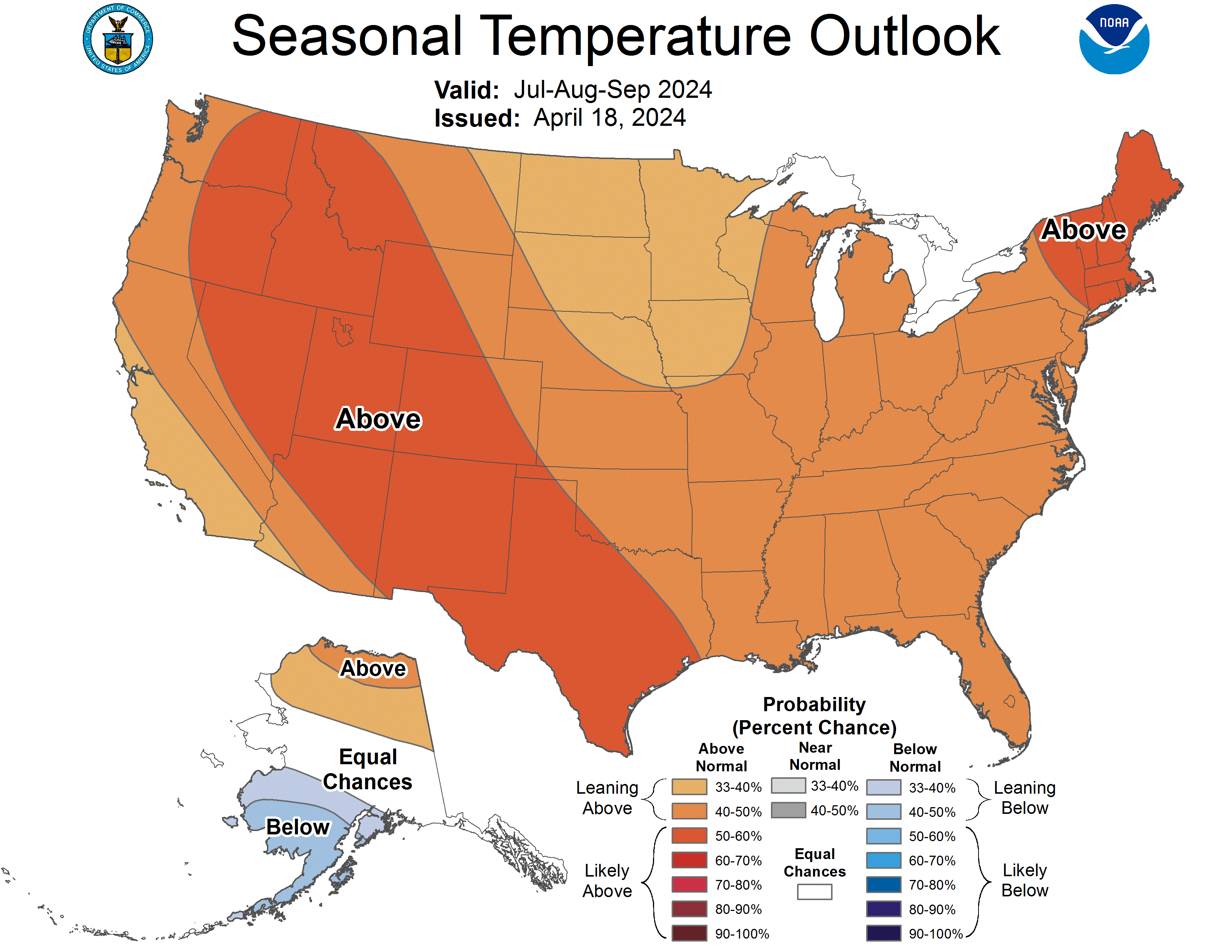
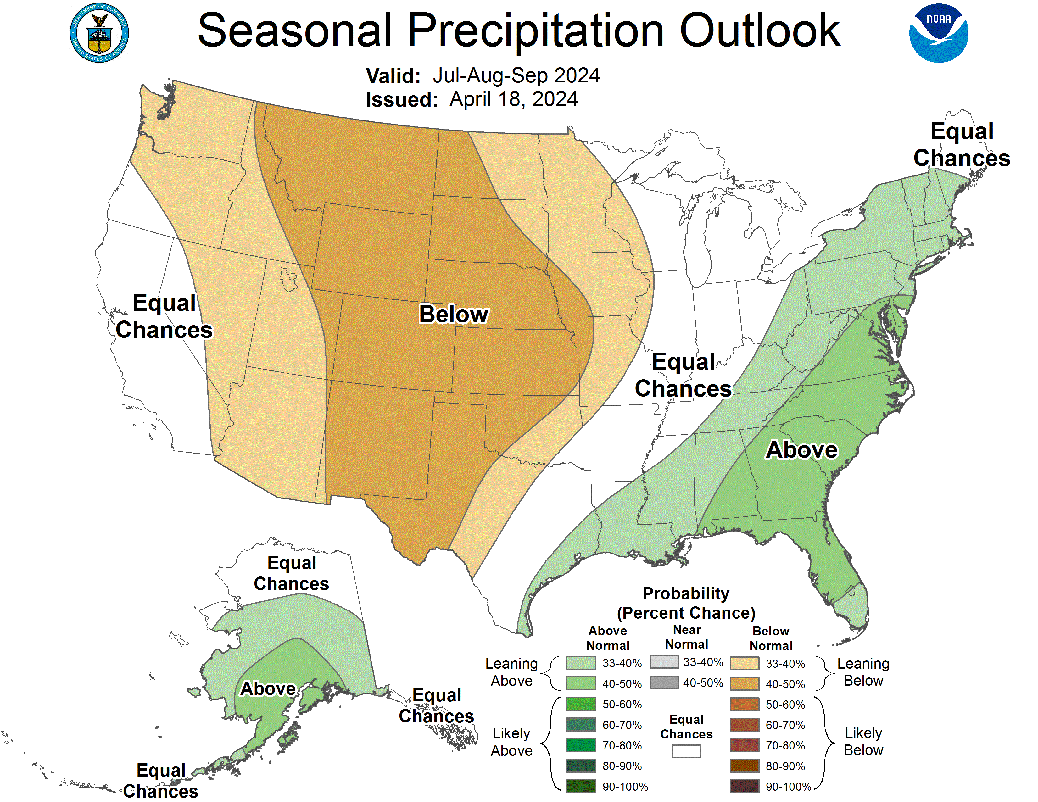
If it was a seasonal weather forecast for another weather domain for the June 1 to December 1 time frame, let's say temps or precip, I think there would actually be a better chance to get it right than with hurricanes.
And we know how poor the skill would be for a Aug-Sep-Oct 90 day seasonal forecast made in May would be. Especially for precip.
https://www.cpc.ncep.noaa.gov/products/predictions/long_range/seasonal.php?lead=3
I watched the presentation; long winded, a big fat maybe burger by too many 15 minute celebrities. imho
DOES ANYONE EVER TRY TO CORRELATE THE CYCLONES & HURRICANES?
IT SEEMS THE CYCLONES ARRIVE EARLIER
JUST CURIOUS, IS ALL.
Good question Jean,
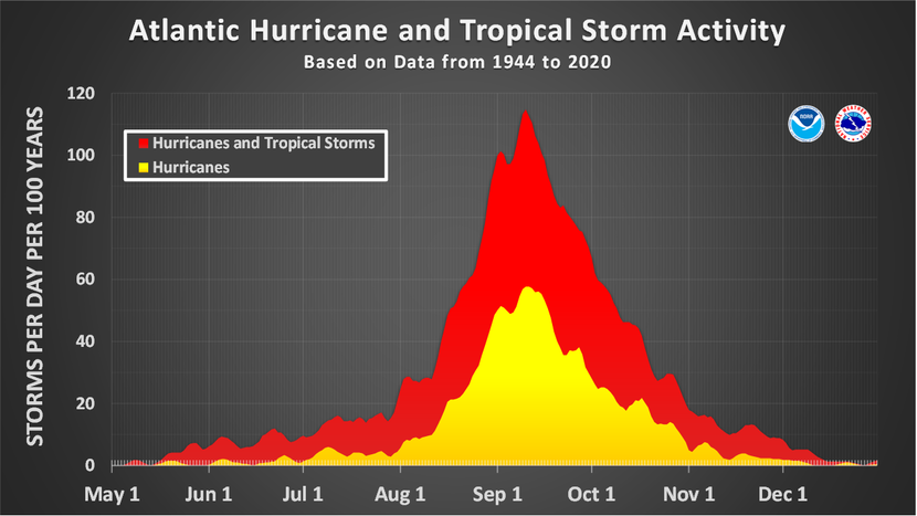
Conditions early in the season are not favorable enough for the tropical cyclones to strengthen into hurricanes.
As the season progresses into a mid-Sept peak both tropical cyclones/storms/hurricanes increase in number on average. This is also the greatest risk for a major hurricanes.
The REAL hurricane season is concentrated between Aug 1 and Nov 1 which is when the vast majority of hurricanes occur and ALL the major ones for the US.
When you get later into the season, most of the hurricanes are farther south, like the Carribean/Central America region where the water temps are still well above 80 degrees.
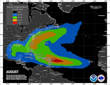
Some awesome data/graphics displayed at this link!
https://www.nhc.noaa.gov/climo/
![[Map of return period in years for hurricanes passing within 50 nautical miles]](https://www.nhc.noaa.gov/climo/images/return_hurr_sm.jpg)
Estimated return period in years for hurricanes passing
within 50 nautical miles of various locations on the U.S. Coast
++++++++++++++++++++++++++++++++++++++++++++++++++++++++++++++++
![[Map of 1900-2010 Major Hurricane Strikes by U.S. counties/parishes]](https://www.nhc.noaa.gov/climo/images/strikes_us_mjr_sm.jpg)
1900-2010 U.S. Major Hurricane Strikes
++++++++++++++++++++++++++++++++++++++++++++++++++++++
This was NOAA's "outlook" last year:
They predicted an ABOVE normal season.
")
How did they do? Their outlook was high.
The 2022 Atlantic hurricane season ends Nov. 30 with a final tally of 14 named storms, eight hurricanes and two major hurricanes. Originally expected to be an above-average season, this year’s season wraps up as the first near-average season since 2015. The last six years have seen a streak of above-average seasons from 2016 to 2021.
NOAA’s pre-season outlook published in May called for 14-21 named storms, 6-10 hurricanes, and 3-6 major hurricanes.
Matthew Rosencrans, the lead hurricane forecaster at the CPC, verified in a news release that the 2022 seasonal activity fell within NOAA’s predicted ranges. Originally, the Climate Prediction Center at NOAA gave a 25% chance of a near-normal season.
++++++++++
I don't get that last statement
How about Colorado States outlook?
If you look at the stats, they were MUCH too high in 6 out of the 7 categories below. I would call that one of the worst busts ever! Even their August updated forecast was doo doo.
What do you think, Larry?
Colorado State University’s Department of Atmospheric Sciences also publishes several outlooks before and during the season. The observed conditions are below what CSU originally expected for this season. The CSU outlook published in April originally predicted 19 storms, nine hurricanes, and four major hurricanes.

Phil Klotzbach, senior research scientist at CSU’s Department of Atmospheric Sciences, said he characterizes this season as “the most abnormal, normal hurricane season on record.”
“We had no storms in August, a very busy September, a quiet October and a very busy November,” Klotzbach said.
The pacing of this season, Klotzbach explained, is what makes it so “abnormal.” According to the National Hurricane Center, most Atlantic activity occurs between mid-August and mid-October. However, there were no named storms between July 3 and Aug. 31, the first time this has occurred since 1941. October also ended with the lowest Accumulated Cyclone Energy, a metric used by NOAA to measure frequency, intensity and duration of tropical activity, since 2009. The three hurricanes formed during November ties 2022 with 2001 for the most November Atlantic hurricane formations on record. And Hurricane Nicole made history as the latest calendar year hurricane to make landfall on Florida’s east coast ever.
September saw the most activity, and destruction. Six storms including the two major hurricanes of this year, Fiona and Ian, brought high winds, flooding and storm surge to Puerto Rico and Florida, respectively. Hurricane Fiona brought over two feet of rain to some areas of Puerto Rico, and Hurricane Ian had the fifth strongest winds on record. The latter is also shaping up to be a multi-billion-dollar event with more than a hundred fatalities.
Kloztbach said this season highlights that a hurricane season can have peaks and troughs.
MIKE ~ WHAT I'M GETTING AT IS: IS THERE SOMEPLACE, ON LINE, THAT HAS STUDIED THE NUMBER OF & SEVERITY OF; PACIFIC CYCLONES, BEFORE OUR HURRICANE ACTIVE SEASON GETS STARTED?
I WOULD THINK THERE'S GOTTA BE A SIMPLIFIED ACCOUNTING OF ~ (EXAMPLE) THERE WERE 20 PACIFIC CYCLONES, WITH 3 BEING MAJOR & 15 ATLANTIC CYCLONES WITH 2 THAT TURNED INTO MAJOR HURRICANES ~ ( LOL ~♬ IN THE YEAR 2525")
"The eastern Pacific hurricane season runs from May 15 to November 30. The eastern Pacific basin extends from Mexico and Central America westward to 140°W. Based on a 30-year climate period from 1991 to 2020, an average eastern Pacific hurricane season has 15 named storms, 8 hurricanes, and 4 major hurricanes. The first named storm typically forms in early to mid-June, the first hurricane tends to form in late June, and the first major hurricane forms in mid-July."
I DON'T KNOW WHERE THE ONE THAT PUMMELED GUAM, ORIGINATED. DO YOU?
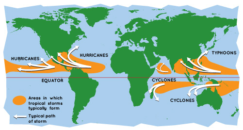
OK, I didn't realize that you were asking about TYPHOONS in the Pacific. Is that what you mean by cyclones?
Regardless, this leads to an extension of this great discussion.
There is a region in the world that actually uses the term CYCLONES.
Yes, there's tons of data on typhoons cyclones and hurricanes. All the exact same thing but the names are different in different places.
There is no strong correlation between them, other than the fact that the same conditions cause them all to form and intensify.
There are almost twice as many Typhoons and they get stronger because the Pacific Ocean is warmer and bigger.
Then
We should note that there are never any hurricanes in the SOUTH Atlantic(only one was in 2004) and discuss that too.
+++++++++++
https://www.nhc.noaa.gov/aboutrsmc.shtml
+++++++++
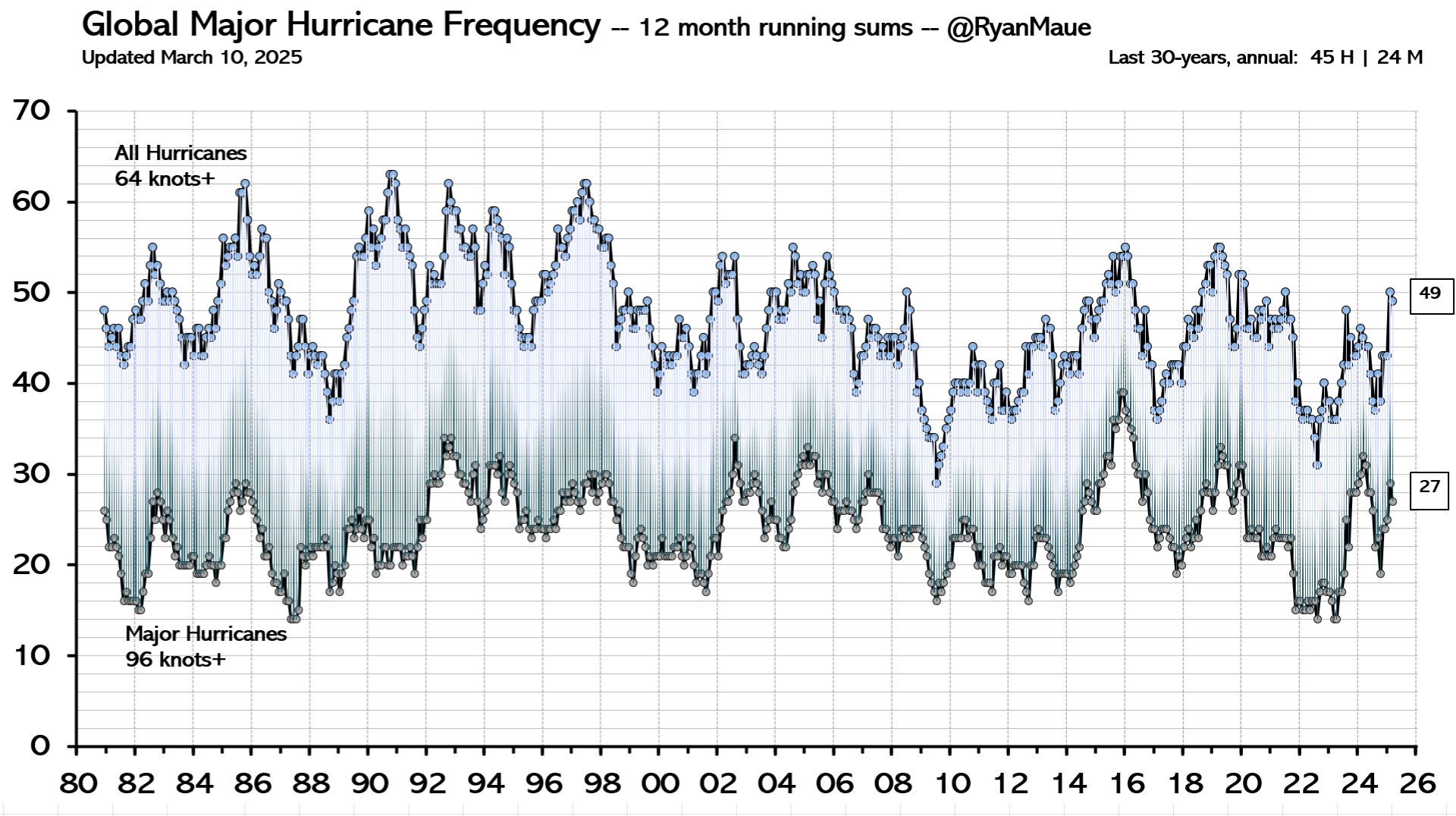
Most people think that climate change is increasing the number of hurricanes. It's the exact opposite, except in the North Atlantic Basin. Hurricane frequency everywhere except that location has dropped.
Intensity is STRONGER and rains amounts greater though because warmer air/oceans can hold more moisture. For every +1 Deg C increase, the air mass can hold 7% more moisture.
27 June 2022
https://www.carbonbrief.org/tropical-cyclones-now-13-less-frequent-due-to-climate-change/
++++++++++++
https://www.epa.gov/climate-indicators/climate-change-indicators-sea-surface-temperature
Average Global Sea Surface Temperature, 1880–2020

"OK, I didn't realize that you were asking about TYPHOONS in the Pacific. Is that what you mean by cyclones?" YES, I JUST FORGOT TO TYPE TYPHOON. LOLOLOLOLOL
(I HAVE A SERIOUS PROBLEM WITH SOME WORDS. LOL THEY LITERALLY MAKE ME LOL ~ BUFFOON ~ TYPHOON ~ BABOON ~ BALLOON, ETC.. LOLOLOL THEY ALWAYS HAVE!! THEN, I GET TO THINKIN' OF "WHO'S ON 1ST" & THAT'S ALL SHE WROTE! LOL I LOSE ALL COMPOSURE, NO MATTER WHERE I'M AT.
I DO KNOW THE NAMES CHANGE , DEPENDING ON THE LOCATION. ✔
I SEE YOU'VE POSTED MORE LINKS THANK YOU
"Intensity is STRONGER and rains amounts greater though because warmer air/oceans can hold more moisture. For every +1 Deg C increase, the air mass can hold 7% more moisture. " I'VE THOUGHT / WONDERED, FOR QUITE A FEW YEARS AS TO WHAT ALL CAN WARM THE OCEANS. I CAN'T HELP BUT THINK MISSLES ~ SPACE 'JUNK" ~ METEORS ~ SHIPS ~ TSUNAMI / UNDER WATER VOLCANO ~ ETC., ALL CONTRIBUTE.
MY BRAIN HAS ALWAYS LIKED TO WONDER. LOL
Here's more interesting graphs:
https://www.epa.gov/climate-indicators/climate-change-indicators-tropical-cyclone-activity

+++++++++++++++++++
This guy has extremely credible stuff that isn't based on bad science assumptions about climate change.
Last year, for instance featured an historically LOW amount of cyclone energy on the planet.......the complete opposite of the fake climate crisis narratives! I think that part of this may related to the beneficial decrease in temperature gradient from north to south and less need by the planet to exhaust excessive heat in the lower latitudes.
https://climatlas.com/tropical/
Note that lack of evidence does NOT mean absence of evidence. It means we currently have incomplete knowledge or inadequate methods and/or observations. We can still have medium to high confidence in an expected outcome based upon fundamental understanding of physics and fluids.
Recent historically low global tropical cyclone activity: Geophys. Res. Lett. (2011), Abstract:
| Tropical cyclone accumulated cyclone energy (ACE) has exhibited strikingly large global interannual variability during the past 40-years. In the pentad since 2006, Northern Hemisphere and global tropical cyclone ACE has decreased dramatically to the lowest levels since the late 1970s. Additionally, the frequency of tropical cyclones has reached a historical low. Here evidence is presented demonstrating that considerable variability in tropical cyclone ACE is associated with the evolution of the character of observed large-scale climate mechanisms including the El Nino Southern Oscillation and Pacific Decadal Oscillation. In contrast to record quiet North Pacific tropical cyclone activity in 2010, the North Atlantic basin remained very active by contributing almost one-third of the overall calendar year global ACE. |
|---|
Last year, Biden insisted that Ian was proof of the climate crisis. You have to ignore all the rest of the data for that to make any sense.
++++++++++++++++++++
The graph below shows a future model projection of a big decrease in storms/hurricanes(red) that are less than around 140 mph, which is the vast majority of them.
It also shows a tiny increase in the number of hurricanes with wind speeds of 140+ mph winds. Overall, climate change model forecasts represent a huge drop in the ACE index(Accumulated Cyclone Energy)
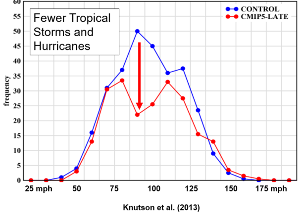
The surprising part of the graph is in the middle, where there is a significant dip in the number of storms with maximum wind speeds in the range of 75 to 130 or so mph—Category 1, 2 and 3 hurricanes on the Saffir-Simpson Hurricane Scale. This bears repeating: global warming due to increasing greenhouse gases may lead to fewer hurricanes in the Atlantic, although their peak winds are expected to increase a few percent. The mechanism for fewer Atlantic tropical storms and hurricanes with climate warming in most model projections is not a fully settled issue in climate science. The projected decrease in storm genesis may be related to increased wind shear in storm development regions or other environmental factors. Recent work suggests a role for decreases in tropical cyclone "seed disturbances" in producing the reduction in tropical storm genesis.


NATIONAL HURRICANE CENTER and
CENTRAL PACIFIC HURRICANE CENTER
https://www.nhc.noaa.gov/satellite.php
https://www.ssd.noaa.gov/jma/twpac/h5-loop-vis.html
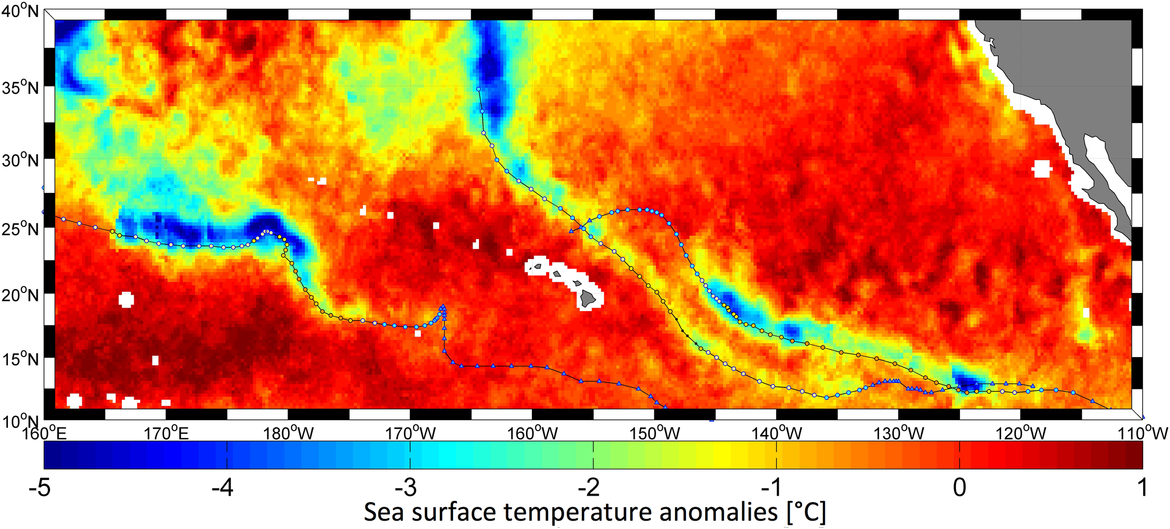
OKAY, MIKE ~ HERE'S ANOTHER QUESTION : DO THE WATERS WARM AS A STORM INTENSIFIES ~ DOES IT COOL ~ OR DOES IT REMAIN CONSTANT?
Jean,
Actually the waters COOL as the storm intensifies because it churns up cooler water below.
This is why a stalled hurricane will kill itself. Another item is that the water temp must be at least 79(many claim 80 F) but if the depth of the water that warm is extremely shallow, the churning will make is extremely tough to maintain water temps that warm.
The deeper the very warm water is, the less impact churning has.
You will always find COOLER water in the wake of hurricane because of this churning that brings up cooler water(by several degrees) to the surface. It might take 30 days to recover to the previous water temp as shown in the study below.
https://journals.ametsoc.org/view/journals/mwre/139/12/mwr-d-10-05019.1.xml

https://earthobservatory.nasa.gov/images/88961/hurricane-nicoles-cold-water-wake
https://www.esa.int/ESA_Multimedia/Images/2015/09/Hurricanes_change_temperature_of_sea_surface
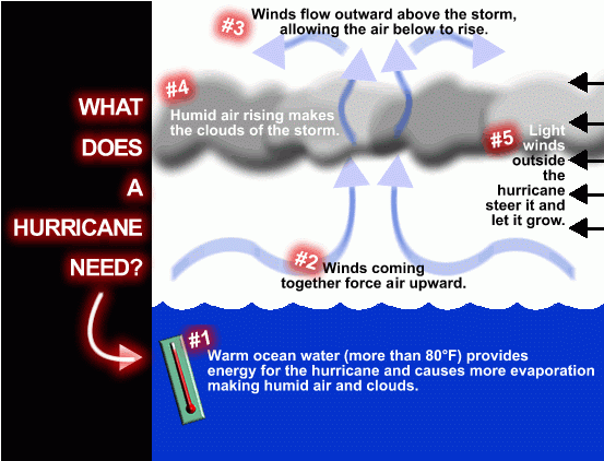
There are six widely accepted conditions for hurricane development:
See link:
How do hurricanes form?
https://oceanservice.noaa.gov/facts/how-hurricanes-form.html