ENSO: Recent Evolution,Current Status and Predictions
All regions are above average with Nino 1-2, still the warmest as has been the case all year.
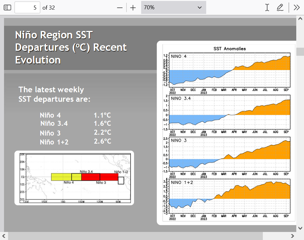
You can see the actual hot spot of Nino 1-2 below.
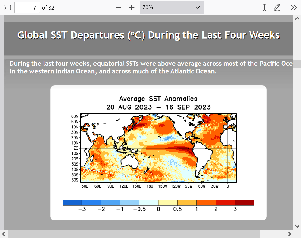
Look closely on the global map below. Notice the cool anomaly off the Mid-Atlantic/Southeast coast. That came from 3 hurricanes churning up cooler water from below up to the surface.
1. Franklin
2. Idalia
3. Lee
The change in temperatures during the last month below REALLY shows the cooling off the coast of the Mid-Atlantic/Southeast from the wake of those 3 hurricanes.
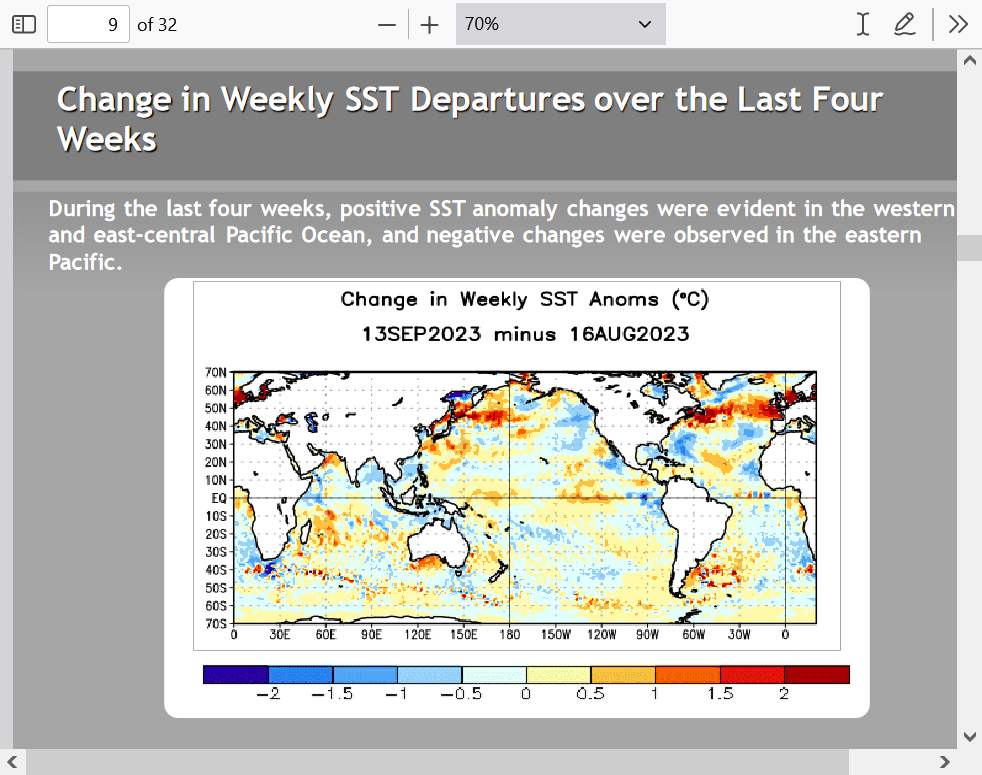
Here's more on that pocket of much cooler water from the hurricanes:
Lee significantly cooled SSTs well ahead of center
Started by WxFollower - Sept. 18, 2023, 8:21 p.m.
https://www.marketforum.com/forum/topic/99073/
+++++++++++++++++
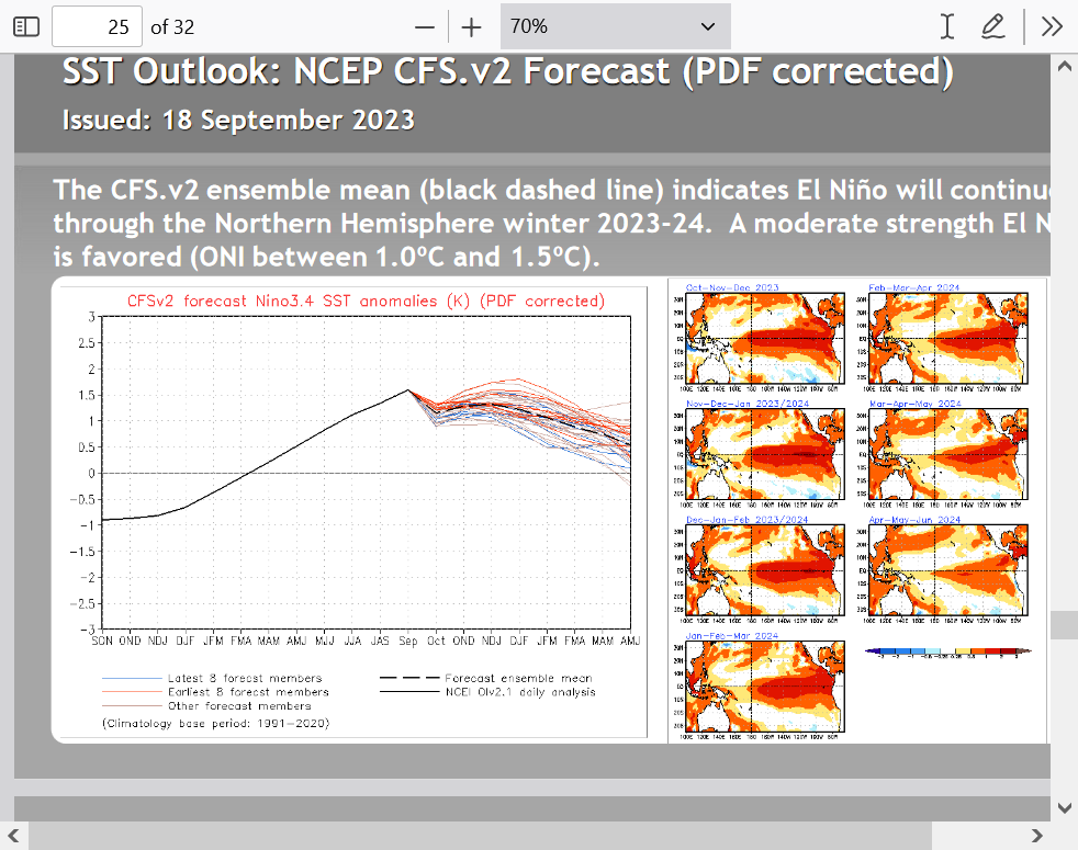
Forecast for the next ~9 months. El Nino weakening very gradually but remaining strong this Winter.
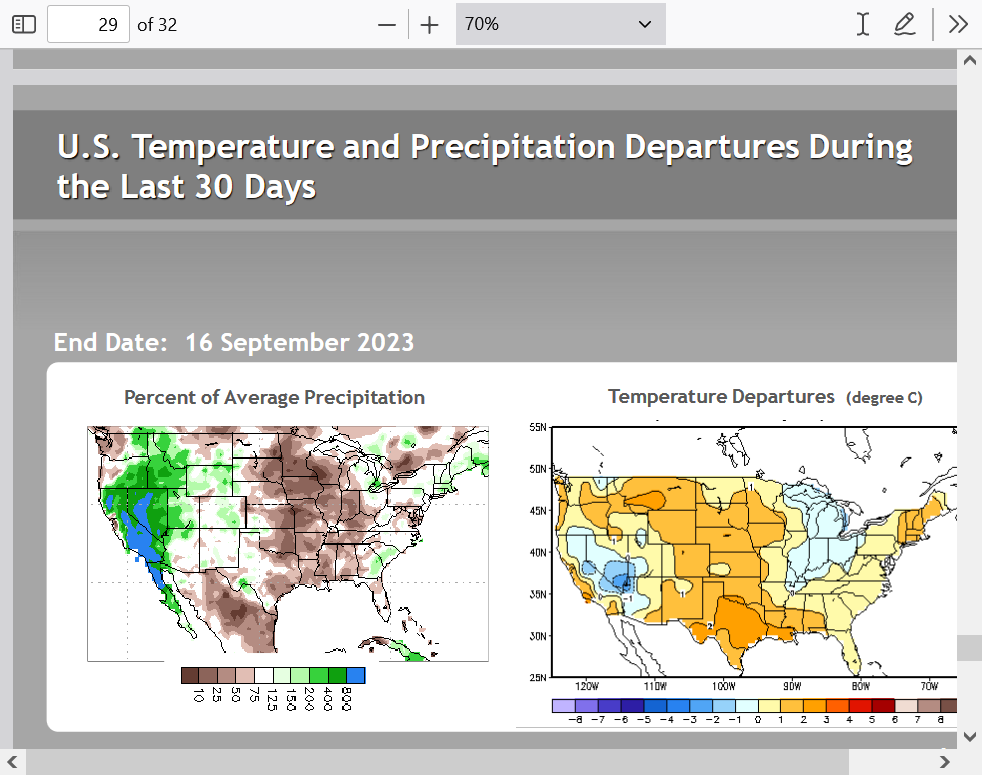
I included this last graphic from the NOAA discussion to show how dry it's been in the Midwest the past month.
Here in Southwest IN, our last rain was 29 days ago at 1.5 inches and was sort of a lucky fluke. Missing that one would have meant 6 weeks since the last rain!
What does this mean for our weather?
Snow lovers?
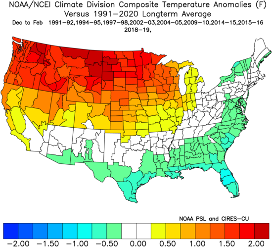
Brian Brettschneider@Climatologist49
Correlation between Dec-Feb snowfall and the Dec-Feb El Nino Southern Oscillation (ENSO) index. For an El Nino winter like we will have this year, green means snowier than typical and purple means less snowy than typical.
Much more to come!
Kris Karnauskas@OceansClimateCU
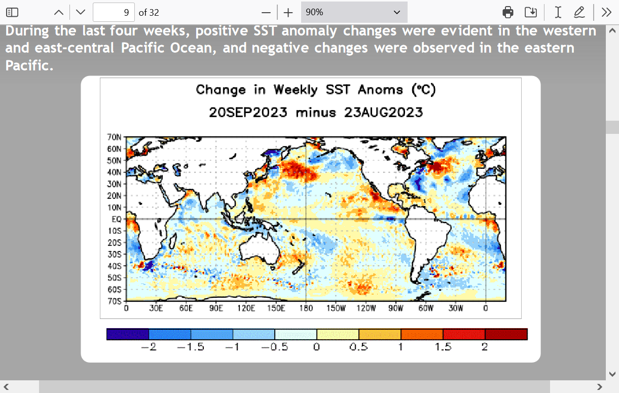
Daily tropical Pacific SST anomalies over the last month and a half. #ElNiño
MetMike
Are you suggesting the Midwest will NOT be replenishing its subsoil deficits this winter?
Let me advance the discussion a bit more for you tjc. Sorry it was late last night.
I believe the main element contributing to that snow correlation is from temperatures.
The warmer north/Midwest in El Nino causes more rain vs snow to fall. and cooler south causes more snow vs rain compared to average.
More in a minute.
I am too old to enjoy snow, when rain will be just fine.
Will await your follow up.
Another source anticipates poor growing (lack of moisture) for several years? Thoughts?
Sorry for the long delay, tjc!
https://opensnow.com/news/post/el-ni-o-is-it-too-early-to-think-about-next-winter
This is the typical flow pattern and weather anomalies from it based on the average of all El Nino Winters going back at least 3 decades. Keep in mind that if the northern/Polar stream is stronger or weaker than usual or the El Nino amplified, Pacific jet stream is aimed in a different direction everything below will be different in the Winter of 2023/24. It would likely just result in a SHIFT in one direction of the associated weather patterns to adjust for the different directions/locations of these 2 jet streams.
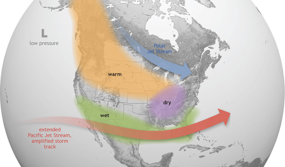
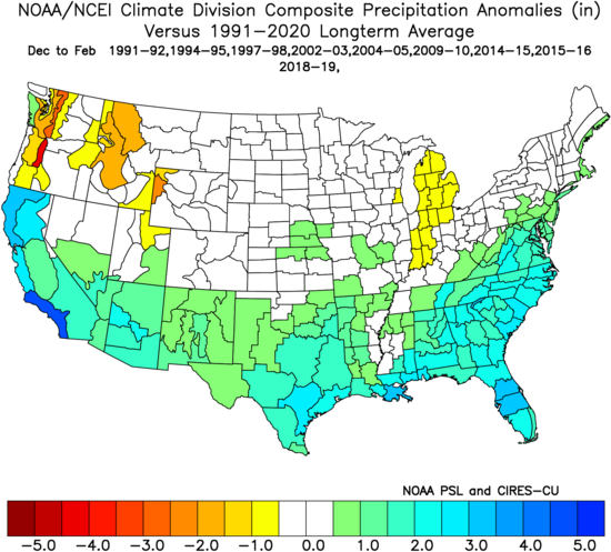
This is a composite for all the selected El Nino Winters listed at the top of the maps
For temperatures
1. Very mild northwest half of the country.
2. Chilly southern tier to East Coast.
As mentioned before, If the Polar jet stream is much stronger for reasons independent of the El NIno, then temperatures will be much cooler than this.
For precipitation
Precipitation is above for around the southern half of the country and more pronounced above in parts of California, TX and the Southeast. Slightly dry in the Great Lakes/Ohio Valley but no strong tendency in the Midwest. Dry spots in the Northwest.
Here's that snow map from above again.
1. The decreased snow in the northern half is from a combination of milder temps causing more rain vs snow compared to average and a slightly drier than average tendency from the energized Pacific jet stream being farther south.
2. More snow in the Southern half, for the exact same reasons on the other side of the weather/El Nino coin. Main Pacific jet stream is located here with added moisture AND temps are cooler than average so that increases snow vs rain compared to an average El Nino Winter.
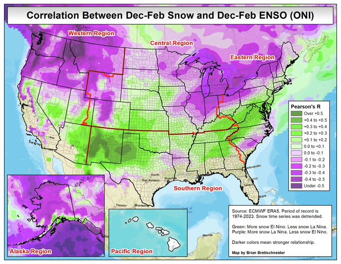
Keep in mind that the El Nino energized Pacific jet stream can absolutely take a different path than the one depicted as the average above. It could easily be aimed farther north and result in the increased moisture hitting the Midwest.
Same with the Polar Jet Stream which will have its course determined by several things(that can't be predicted in September), some unrelated to the El Nino.
Regardless of that, these are some pretty high probability analogs for a 3 month period as analogs go!
September 25 ENSO/El Nino update:
Look at the cool temperature anomalies (change in the last 4 weeks) off the East Coast caused by the 3 hurricanes, Idalia, Franklin and Lee (remnants).
They churned up cooler sub surface water to the surface.
Lee significantly cooled SSTs well ahead of center
6 responses |
Started by WxFollower - Sept. 18, 2023, 8:21 p.m.
This is a wonderful post and excellent points that I was not fully aware of.
Thanks!
I DON'T KNOW THE "LINGO", BUT.... I THINK A LOT OF PEOPLE THAT DO, HAVE GOTTEN A TAD MORE EDUCATED... IF THIS ARTICLE HOLDS TRUE.
YOU'RE WELCOME, MIKE
