When historians look back on Hurricane Ian, the storm is likely to be in a category of its own, leaving tens of billions of dollars in property damage and an as-yet-unknown death toll in its wake.
“There’s not one storm that combines the devastating surge with extreme rainfall elsewhere,” said Ryan Truchelut, chief meteorologist with Tallahassee-based WeatherTiger. “It’s unique, really, it’s one of a kind. There are not a lot of reference points.”
Whether Ian ultimately supports conclusions that 90% of hurricane deaths are caused by water and not wind will be known in due time. In Florida, the state Medical Examiners Association reported 25 confirmed deaths as of Saturday afternoon. Most of the Florida victims drowned.
Charley produced little storm surge and just 2 inches of rainfall in Orlando, but its wind gusts of 105 mph were “worse than Ian’s,” Truchelut said.
Historically, the deadliest hurricanes in history have been those that produced heavy storm surge and massive flooding, rather than tighter, smaller storms that pack a lot of wind and comparatively little water.
Storm surge is produced by water being pushed toward the shore by the force of winds moving cyclonically around the storm, according to a post on the National Hurricane Center’s website. The force is compounded by fierce winds and pounding waves, and no structure not specifically built to withstand such forces can avoid being demolished by water that weighs 1,700 pounds per cubic yard, the post says.
Southwest Florida’s shallow continental shelf has long triggered fears that a large and powerful storm could send a massive and deadly volume of water far inland, devastating property and lives.
Tampa Bay Times
Historic storm surge. Record flooding. Ian’s lesson in the rising risk of hurricanes
“Storm surge is gonna be what this storm is remembered for.”
But for most of Florida, the greatest hurricane threat was the water. The combination of epic storm surge along the coast and unprecedented rains inland flooded homes across a huge swath of the state.
“This was probably the largest area of storm surge damage that we’ve seen in recent history,” he said. “People look at the images and say ‘that was wind.’ No, it was storm surge. That’s the power of water.”
It’s why some scientists have advocated for a new approach to categorizing storms, since the Category 1 to Category 5 Saffir-Simpson scale only measures wind speed. Even “just” Category 1 storms can cause tremendous damage with storm surge and flooding, like Hurricane Fiona in Puerto Rico earlier this month. “We get all geared up — as we should — for Cat 3, 4, 5, but often the most impactful in terms of rainfall can be a tropical storm,” Marshall Shepherd, director of the University of Georgia’s atmospheric sciences program, told the Herald in June.
AP NEWS
The bulk of the deaths confirmed in Florida were from drowning in storm (surge) waters, but others from Ian’s tragic aftereffects.
At least 31 people are confirmed dead, including 27 people in Florida mostly from drowning.
Anthony Rivera, 25, said he had to climb through the window of his first-floor apartment during the storm to carry his grandmother and girlfriend to the second floor. As they hurried to escape the rising water, the storm surge washed a boat right up next to his apartment.
Eddie Wilder, who has been coming to Pawleys Island for more than six decades, said the storm was “insane to watch”. He said waves as high as 7.6 metres (25 feet) washed away the pier, just two doors down from his home.
“We watched it hit the pier and saw the pier disappear,” said Wilder. “I’ve seen quite a few storms and this one was wild … We had a front-row seat.
https://phys.org/news/2019-05-storm-surge-dangerous.html
, blast into coastal towns like Tacloban")
A storm surge was to blame for many of the 7,350 deaths in 2013's Super Typhoon Haiyan, which saw a wall of water estimated to be 7.5-metres-high (more than 24-feet), blast into coastal towns like Tacloban
The surge happens when sea levels rise dramatically during a storm, sending a destructive wall of water gushing over people and property on land.
Why is it so dangerous?
In previous storms, people have failed to flee because they did not grasp the storm surge's deadly threat.
Also, surges can extend for dozens of miles inland, overwhelming buildings quickly and cutting off roads. People can end up drowning in their cars or homes.

The power of a surge is dictated by factors including a storm's size and intensity, as well as the geography of the coastline and sea level.
Bays tend to funnel the surge, pushing water to higher levels, according to the Hong Kong Observatory.
One of the best protections is clear, early warnings to people in the surge's sights and evacuations to areas of higher elevation.
https://texaswaternewsroom.org/articles/a_coastal_flood_modeler_explains_compound_flooding.html
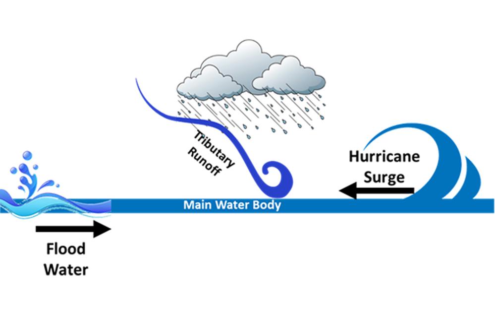
What is compound flooding?
Compound flooding refers to a phenomenon in which two or more flooding sources occur simultaneously or subsequently within a short period of time.
In terms of coastal flooding, a compound flooding event is flooding caused by the interaction of the open ocean, atmosphere, and watersheds. The most common type of coastal compound flooding—a combination of storm surge and riverine flooding—can produce floodwaters that are longer in duration and more widespread than anticipated.
+++++++++++++++++++++++++++
COMPOUND FLOODING: EXAMPLES,
METHODS, AND CHALLENGES
https://nsiteam.com/social/wp-content/uploads/2018/08/Wahl_flooding.pdf
Definition(s) of compound events
IPCC, 2012:
(1) two or more extreme events occurring simultaneously or successively; (2)
combinations of extreme events with underlying conditions that amplify the
impact of the events; or (3) combinations of events that are not themselves
extremes but lead to an extreme event or impact when combined. The contributing
events can be of similar (clustered multiple events) or different type(s).
Leonard et al., 2014:
A compound event is an extreme impact that depends on multiple statistically
dependent variables or events.
Zscheischler et al., 2018:
The combination of multiple drivers and/or hazards that contributes to societal or
environmental impacts.
metmike: The component of sea level rise in compound flooding for IAN, comes from an increase in sea levels of 1 inch/decade.
So there was several inches of additional storm surge damage because of the global warming we've experienced the past century.
Previous thread discussing Ian's winds compared to Irma:
https://www.marketforum.com/forum/topic/89366/
Ian's extremely heavy rains compared to recent extremely heavy rain events in Florida:
https://www.marketforum.com/forum/topic/89333/
Some residents said evacuation orders came too late. Gov. Ron DeSantis said forecasts left few options.
“I’ve been in the business of local government and county management for many, many years,” Desjarlais said during the afternoon news conference, watched by about 8,000 people on Facebook. “I don’t remember the last time we had to manage a hurricane that was as difficult as this one.”
Morong said she felt more informed by local weather reports by news stations than by her county’s officials.
“This particular storm went everywhere from the Keys, all the way up to the Big Bend, and even a little bit further west of that, and then back,” Guthrie said.
He said that for Lee County to have successfully evacuated everyone would have taken 48 hours, but at that time, Hurricane Ian was still projected to hit well north of Tampa, closer to Gainesville.
“I may not have evacuated if it had not been for the news reports,” Morong said. “They were the ones who told us of the severity of the storm surge and the danger.”
The same document also notes that Southwest Florida is “the hardest place in the country to evacuate in a disaster,” because of the large population and limited road system.
“It doesn’t help when the national media immediately flocks to one location and that’s your headline time and time again,” Fugate said. “Perception, for a lot of people, is reality.”
So we know that dozens of lives could have been saved if those souls had evacuated.
Please see the detailed history of the hurricane forecasts here to understand the confusion and lack of evacuating.
https://www.marketforum.com/forum/topic/89131/
Many of these products are updated automatically so we don't have saved images. On the other hand, I saved some of them to discuss now.
The GFS (American) model, for numerous days before landfall was on the western edge of the forecast track spreads.
Several days before landfall, this is what the GFS, (much farther west) and the European model (farther southeast but still not far enough southeast) looked like:
https://www.marketforum.com/forum/topic/89131/#89143
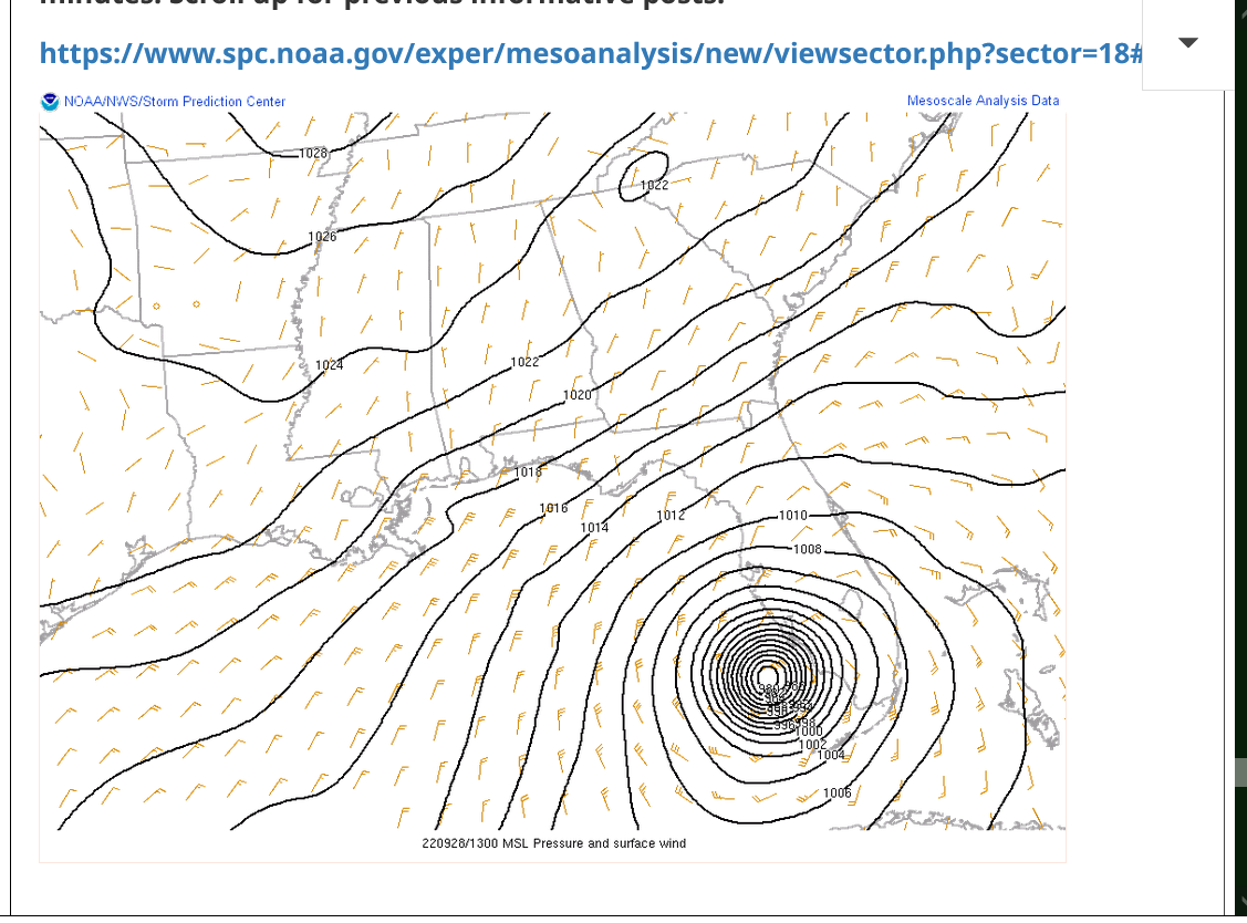
By metmike - Sept. 24, 2022, 11:07 p.m.
European model continues to be the farthest east, last run from 12z below:
GFS/American model is farthest west: 18z run below
https://mag.ncep.noaa.gov/Image.php
+++++++++++++++++++++++++++++++++++++++++++++++
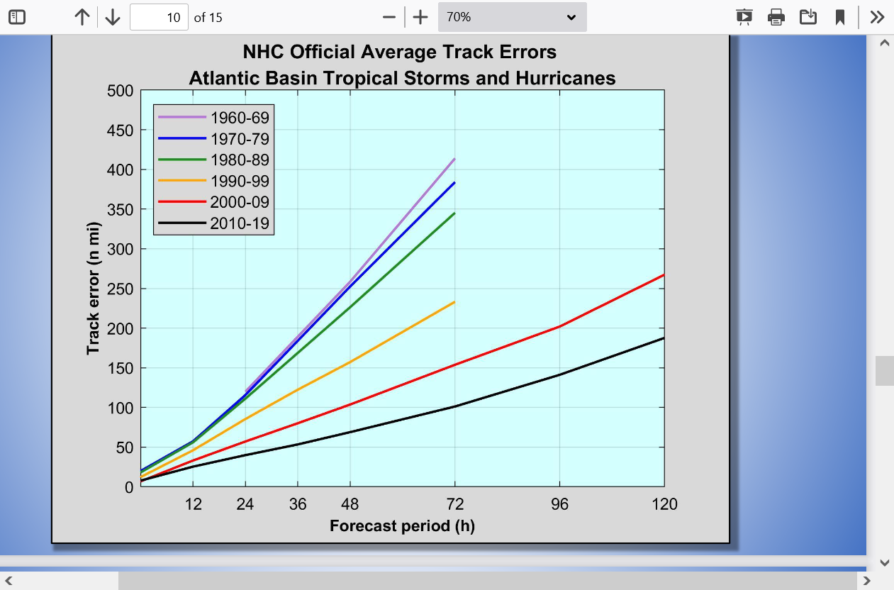
The NHC has to rely on these models for guidance, so they were also too far west/north. If ALL the models are wrong, they will be wrong. That's the science. The models use equations that represent the physical laws in the atmosphere and can solve the equations many millions of times faster than a human.
A good meteorologist can beat model performance by making adjustments based on pattern recognition and correcting for known weaknesses in certain models/situations but when the model busts badly, all the meteorologists will bust. Some, just not as bad as others.
Regardless, the great news is that models are constantly being updated and achieving highER skill levels, especially at long lead times.
Hurricanes Forecasting
& Hurricane in the Models
The Good the Bad & the Ugly
https://www.weather.gov/media/tbw/workouts/2021feb09_ww_models.pdf
Contribution from Climate Change
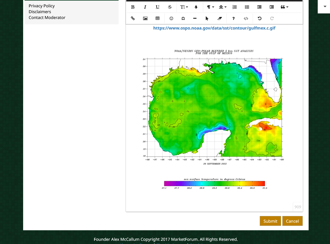
A big factor in the busted intensity (over water) forecast, until the last 24 hours was the pocket of very warm water off the southwest coast of Florida:
https://www.marketforum.com/forum/topic/89131/#89285
Here's our biggest reason for the much stronger than expected hurricane on Wednesday morning:
The pocket of very warm water off the southwest coast of Florida that fueled Ian's intensification overnight/very early am Wednesday!
Cooler temps farther north, closer to the predicted track several days ago, along with more wind shear would have resulted in a weaker hurricane.
https://www.marketforum.com/forum/topic/89131/#89138
Latest frozen images below for future discussions. The ones above update constantly.
Was that very warm pocket caused by global warming?
This is a perfect example to discuss why they were mostly NOT caused by global warming by asking the question:
How did global warming or CO2 know to make it warmer in just the place where a hurricane was going to be before hitting land?
The entire atmosphere/oceans were warmed by X amount (highest in the coldest places/high latitudes) and that X amount is how much global warming contributed to the warmth......EVERY WHERE, including in the Gulf of Mexico
The actual very warm pocket anomaly was caused by natural variation, based on the Golden Rule of extreme weather/climate:
The more extreme a climate or weather record is, the greater the contribution of natural variability.
Or to put it a different way, the larger or more unusual an extreme, the higher proportion of the extreme is due to natural variability.
However, with +1 deg. C being superimposed on the entire system, including GOM temperatures, THAT added heat counts as coming from climate change and that DOES add to a hurricanes ability to strengthen
++++++++++++++++++++++++++++++++++++++++
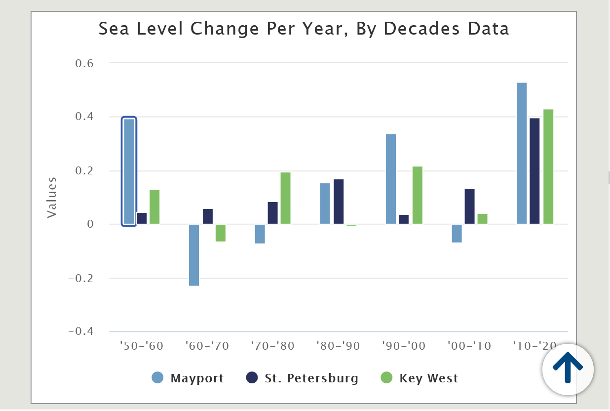
Now let's show you the affect of climate change on sea levels for this area:
Don’t Panic – But Plan
https://warrington.ufl.edu/due-diligence/2021/03/01/sea-levels-around-the-florida-coast/
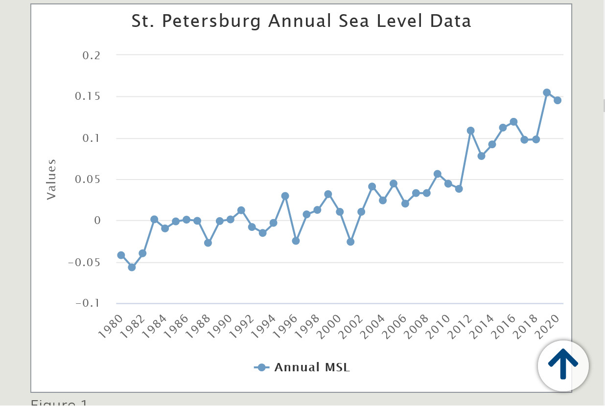
The St. Petersburg station and the Key West station experienced a 7.38 inches and 6.82-inches rise respectively over the same period. (1980-2020)
Please scroll up for previous discussion/analysis.
Putting all the factors together for the added affects of climate change
1. At 1 deg. cooler, Ian would likely NOT have been as strong. And winds potentially might have been 10-20 mph weaker?(wild guess) over water, all things the same vs 100 years ago. As shown here, sustained winds dropped below hurricane force quickly over land:
https://www.marketforum.com/forum/topic/89366/
2. This also means that the storm surge potentially would have been a bit lower a century ago. Not being an authority on the physics, that includes wind speed, angle of approach of the storm, coastline profile/ topography, depth of water/slope and so on, I'll follow up with more on this so we can all understand specifics of storm surge as they apply for each location.
3. With 5-7% less precipitable water, in the slightly cooler climate of 100 years ago(highest increases are at the highest latitudes/coldest places), Ian would have caused around 1 inch less rain in the locations with the heaviest rains.
https://www.marketforum.com/forum/topic/89333/
4. Without climate change, sea levels at this location would have been slightly lower too, making the storm surge a bit less damaging. Sea levels are increasing at just over a foot/century......1+ inch/decade. However, the rate appears to be increasing a bit! The ability of the storm surge to penetrate inland was greater because of climate change.
5. There are other factors to consider than just plucking out 1 hurricane and applying these elements and deciding CO2 is evil. This includes the massive benefits to life (MUCH greater than hurricane damage) from the increase in the beneficial gas, CO2 which is the building block for life.
This has rescued the planet from near CO2 starvation which is greening it up and causing a booming biosphere and the vast majority of life is benefiting during this scientific CLIMATE OPTIMUM. (the fake climate crisis is JUNK science).
There are tremendous benefits of fossil fuels to mankind which is the life blood for the developed countries economies. Petroleum is part of 6,000 products that we use every day. Going back to the old climate of 100 years ago and back down to the the atmospheric level of CO2 then, would cause over a billion people to starve within 3 years and mainly rich people could afford to eat.
https://www.aei.org/carpe-diem/video-of-the-day-life-without-petroleum-based-products/
https://www.marketforum.com/forum/topic/69258/
https://www.cnn.com/2022/10/04/us/hurricane-ian-florida-recovery-tuesday
On Coast Guard flight over battered SW Florida coast, massive damage is evident from storm surge
https://www.miamiherald.com/news/weather/hurricane/article266714486.html
https://www.youtube.com/watch?v=hMmoOWuqHi4
Debris from houses, condos, businesses and resorts was piled up. Palm trees were scattered on beaches. Boats — and even homes — were capsized in bodies of water. All were similar sights in Fort Myers Beach, Sanibel and Captiva.
The Coast Guard’s floodwater rescue teams have located an additional 380 people and 19 pets and also transported seven loads of supplies and 60 first responders to areas in need.
Read more at: https://www.miamiherald.com/news/weather/hurricane/article266714486.html#storylink=cpy
But multiple reports, including one from CBS News, placed the death toll at more than 100 people as of Tuesday, Oct. 5. That makes Ian the deadliest in Florida since the ‘Labor Day Hurricane’ struck the state as a Category 5 storm in 1935.
In an age of ever-improving hurricane forecasts that has seen a general trend toward fewer storm-related fatalities, what went wrong? It’s complicated. But here are a few thoughts from an outside, looking in, perspective.
Ian’s storm surge impacted a densely populated region
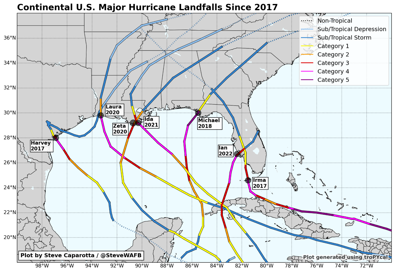
Major hurricanes (Category 3-5) making landfall in the continental U.S. since 2017. All 7 have made landfall along the Gulf Coast, with 6 of the 7 near peak intensity at landfall.
++++++++++++++++
Perhaps we had developed a false sense of security in recent years related to storm surge fatalities due to those storm tracks?
People overestimate their hurricane experience levels
Numerous studies have shown that coastal residents overestimate their hurricane experience levels. One such study published in the Bulletin of the American Meteorological Society (BAMS) found that,
“…they misconstrued the greatest threat as coming from wind rather than water. These misperceptions translated into preparation actions that were not well commensurate with the nature and scale of the threat that they faced, with residents being well prepared for a modest wind event of short duration but not for a significant wind-and-water catastrophe.”
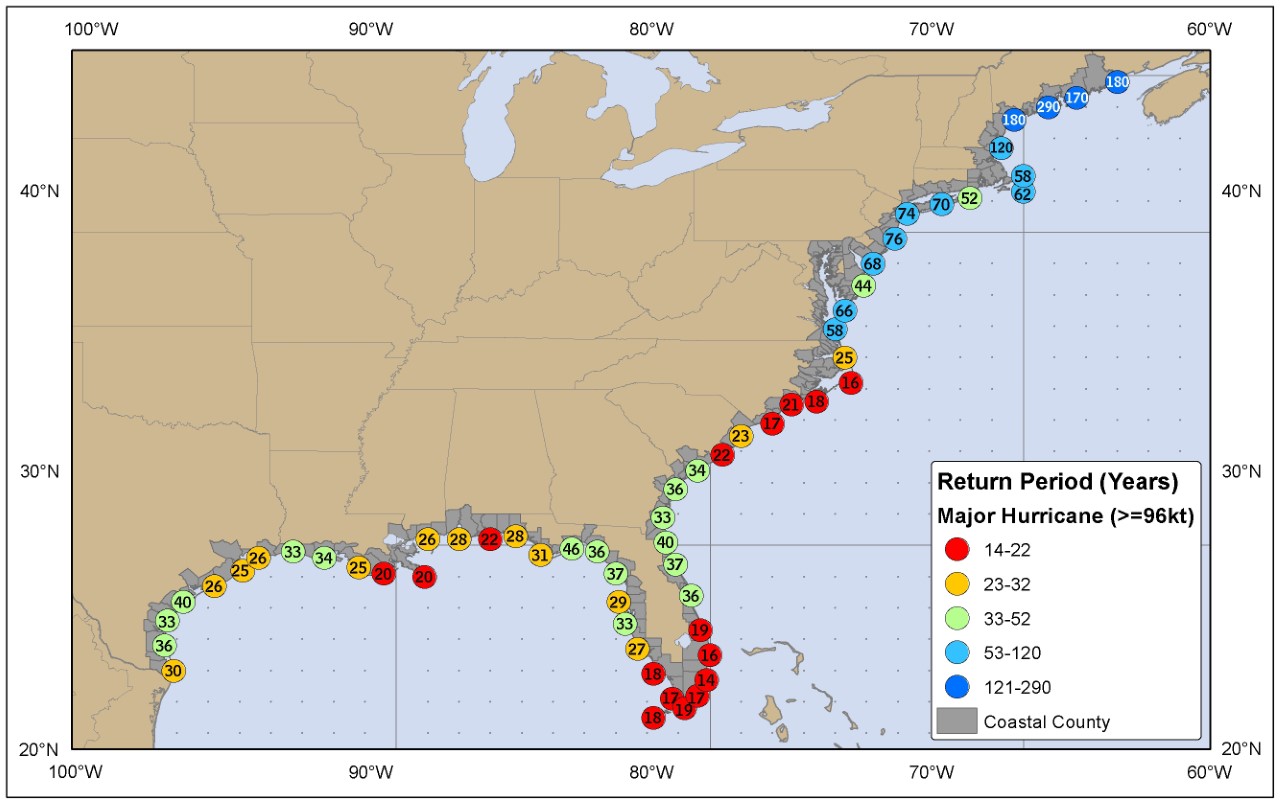
The hardest hit areas from Ian only average a major hurricane passing within 50 miles about once every 30 years.
In this case, even though the tracks were quite similar, Ian was a much larger storm and moving more slowly. Charley’s storm surge peaked in the 6-7 foot range as the compact storm raced to the northeast at around 25 miles per hour. Ian, on the other hand, produced a peak storm surge at least twice as high as Charley, and forecasts leading up to landfall indicated it could get as high as 18 feet in spots. Additionally, Ian was only moving at around 10 miles per hour, something which amplified the storm surge, wind, and rainfall impacts.
https://www.youtube.com/watch?v=bdpa0y2hHXU
https://www.youtube.com/watch?v=ozqGvyTWeAg
The forecast a couple days before Ian hit was for it to hit farther north, around Tampa Bay.
https://citeseerx.ist.psu.edu/viewdoc/download?doi=10.1.1.847.1139&rep=rep1&type=pdf
Summary and Conclusions
[ 43 ] The finite volume coastal ocean model of Chen et al.
[2003] was used to investigate the coastal inundation
potential by hurricane storm surge for the Tampa Bay, FL
region. In view of the fact that this region has not experi-
enced a direct hit by a major hurricane since 1921
Of local
importance is the realization that the Tampa Bay, FL
region, by virtue of a broad shelf width, an elongate and
geometrically complex embayment, and low land eleva-
tions, is vulnerable to inundation by hurricane storm surge.
Moreover, the potential for disaster is as serious as occurred
along the Mississippi coastline during Hurricane Katrina.
++++++++++++++++++++++++
https://6abc.com/hurricane-ian-florida-path-gulf-coast/12272447/
The underwater geology of the Gulf of Mexico is what makes the Gulf Coast particularly unguarded against the massive influx of seawater. The shallow waters in the Gulf, combined with the symmetry of its shallow ocean floor, are what allow the storm surge to be pushed even higher onto land, Ryan Truchelut, chief meteorologist at Weather Tiger, a consulting and risk management firm, told ABC News.
The continental shelf of the Florida Gulf Coast extends quite far offshore -- up to 200 miles in some spots, Truchelut said.
"The waters of the Gulf of Mexico just simply aren't that deep, over a lot of the Florida coastal waters just offshore," he said. "If there's wind pushing water toward that direction, it's shallow, it has nowhere to go. So it kind of amplifies and goes further inland."
Another reason why the Gulf of Mexico is especially vulnerable to hurricanes and storm surge is because of its unique U-shaped coastline, which essentially traps a storm system into a populated region, no matter which way it turns, Truchelut said.
https://www.space.com/hurricane-ian-destruction-satellite-photos
Satellites owned by the U.S. company Maxar Technologies captured devastation along the beach in Fort Myers, in County Lee, on Florida's west coast, where entire neighborhoods were wiped out by the storm surge, which raised sea level by more than 12 feet (3.7 meters) over normal tidal levels, according to Sky News (opens in new tab).
Hurricane Ian “rapidly transformed from a relatively weak storm into a strong one, [a] phenomenon that has become more common” due to climate change.
So reported the New York Times in its daily email newsletter. It also said, “Ian embodies several of the major hurricane trends in recent years, as the world copes with the effects of climate change. It’s a strong storm — and strong storms are becoming more common in the Atlantic Ocean, as its surface water has warmed.”
The prayers of a nation go out to the people in Florida devastated by Hurricane Ian, particularly those in the Ft. Myers area. Ian was indeed one of the most powerful and destructive hurricanes ever to strike southwest Florida.
Unfortunately, the tragedy is compounded by climate-change activists who are using it for political purposes. They blame Ian on global warming. Headlines in the mainstream media claimed Ian was the fourth-strongest hurricane ever to hit Florida and that its strong winds were caused by global warming. Both statements are wrong.
The strength of a hurricane can be determined in two ways. First, you can fly into the storm and measure the winds. Second, you can drop a barometer into the eye and determine the pressure. There is an excellent relationship between wind and the pressure in the eye. The lower the pressure, the stronger the winds. If you know one, then you can calculate the other. For decades before the 1990s, pressure was the main factor in determining the strength of a hurricane.
Using pressure, Ian was not the fourth-strongest hurricane in Florida history but the tenth. The strongest hurricane in U.S. history moved through the Florida Keys in 1935. Among other Florida hurricanes stronger than Ian was another Florida Keys storm in 1919. This was followed by the hurricanes in 1926 in Miami, the Palm Beach/Lake Okeechobee storm in 1928, the Keys in 1948, and Donna in 1960. We do not know how strong the hurricane in 1873 was, but it destroyed Punta Rassa with a 14-foot storm surge. Punta Rassa is located at the mouth of the river leading up to Ft. Myers, where Ian made landfall.
Note well: all these hurricanes occurred before SUVs, so CO2 and the warming it purportedly causes were not their cause.
When historians look back on Hurricane Ian, the storm is likely to be in a category of its own, leaving tens of billions of dollars in property damage and an as-yet-unknown death toll in its wake.
“There’s not one storm that combines the devastating surge with extreme rainfall elsewhere,” said Ryan Truchelut, chief meteorologist with Tallahassee-based WeatherTiger. “It’s unique, really, it’s one of a kind. There are not a lot of reference points.”
Mike,
One thing about Charley that's kind of unique. It was moving so fast that its very strong winds went very far inland. But, it was so much smaller that its very high winds were in only a small area and they lasted for only a short time. So, it might have done more damage than either Ian or Irma in isolated places well inland....perhaps in some parts of, say, Polk county. But most places got less damage. I'm just speculating here. Also, the oranges were much smaller when Charley hit in mid August....no more than golf ball size as I recall.
Yes, I remember Charley extremely well, Larry.
That was back in the days when natural gas would go nuts over hurricanes threatening the central and especially western GOM. Charley was not one of those.
Note the underlined verbiage below. Wow! Sustained winds increased 35 mph in 3 hours.
https://en.wikipedia.org/wiki/Hurricane_Charley
Then Charley rapidly intensified, strengthening from a 110 mph (175 km/h) hurricane with a minimum central barometric pressure of 965 mbar (965 hPa; 28.5 inHg) to a 145 mph (235 km/h) hurricane with a pressure of 947 mbar (947 hPa; 28.0 inHg) in just three hours. It continued to strengthen as it turned more to the northeast, and made landfall near the island of Cayo Costa, Florida as a 150 mph (240 km/h) Category 4 hurricane with a pressure of 941 mbar (941 hPa; 27.8 inHg) at approximately 1945 UTC on August 13.[4][7] An hour later, the hurricane struck Punta Gorda as a 145 mph (235 km/h) storm and then passed up through Port Charlotte and the Charlotte Harbor.[3] However, the eye had shrunk before landfall, limiting the most powerful winds to an area within 7 mi (11 km) of the center.[3]
Charley weakened considerably due to its passage over land, but still retained sustained winds of about 85 mph (135 km/h) as it passed directly over Orlando between 0020 and 0140 UTC August 14; gusts of up to 106 mph (171 km/h) were recorded at Orlando International Airport.[4] It cut a swath of destruction across Florida, also passing near Kissimmee.

Ian was so slowly moving, that it's no wonder why the storm surge was so high. As opposed to other hurricanes in the past, that moved a bit faster. It makes sense in the fact that it had more time and wind velocity to drive the ocean water further and higher.
While I feel compassion for what the Floridians have had to endure, if I were living in central FL, between Tampa and Orlando, I wouldnt have evacuated either. But on the coast? You bet!
As for the climate change thing. We are experiencing climate change. And no doubt that it will change, has changed, the weather in certain ares of the world. What our modern day children havent yet realized, is that climate change is an ongoing thing. Not static at all. Historically proven through ice cores. If they dare to venture that far into actual knowledge. Something beyond the latest hiphop, drugs, and government propoganda. Perhaps I expect too much. Kinda like for the Biden supporters/voters.
Thanks Mark,
Going back to the old climate and CO2 level from 100 years ago would cause 1 billion people to starve to death within 3 years and food prices would more than triple. Only the rich could eat.
In addition, eliminating fossil fuels, which make up or are used to manufacture almost all the world synthetic fertilizers would crush crop yields and starve anther 1 billion
On the day before Ian’s landfall, the hurricane center put the storm surge forecast in the area at 8-12 feet, but by the morning of Sept. 28, the forecast had been increased to 12-18 feet.
Most areas the post-Ian crew surveyed around Fort Myers Beach showed water levels 10-12 feet above the average of the highest high tides recorded in the area, Lindner said.
The 10-15 feet peak high water levels at Fort Myers Beach puts Ian among some of the higher storm surges in history in the Atlantic basin but well below peak water levels reported in some of the most legendary storms on the northern Gulf Coast.
In 2005, Hurricane Katrina’s storm surge reached 25-28 feet along the Mississippi coast at Bay St. Louis. Long-time residents there were shocked at the height of the water, believing no storm would ever surpass 1969’s Hurricane Camille, which pushed a 24.6-foot storm surge into Pass Christian, just east of Bay St. Louis.
+++++++++++++++++++++++
Ian's storm surge topped 15 feet in Ft. Meyers area with many/most of drowning deaths and property damage associated with Ian being a result of this close to the shore.
https://weather.com/storms/hurricane/video/ians-storm-surge-topped-15-feet-in-some-areas