
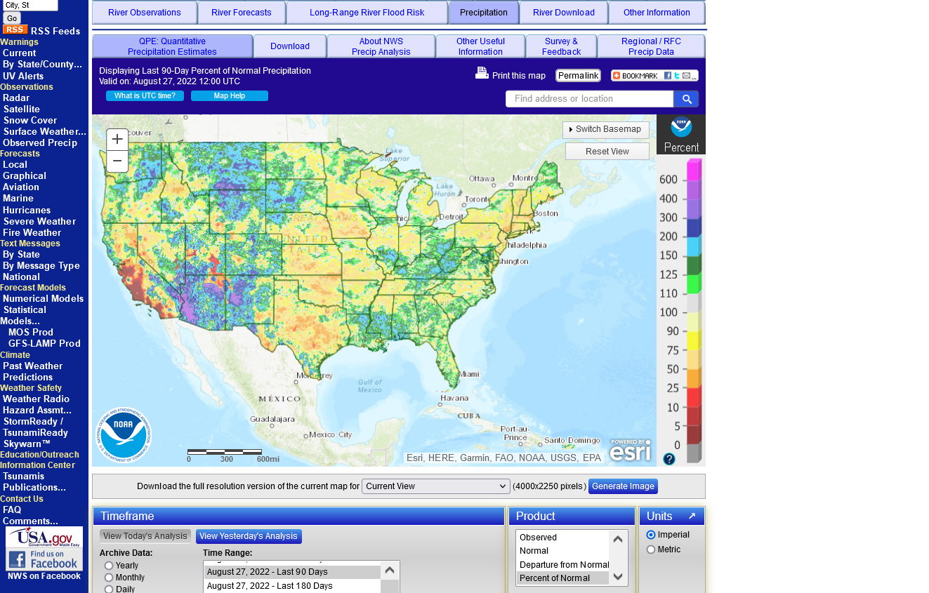
The lower Colorado River Basin is experiencing an unusually wet Summer monsoon season here in 2022.
A few locations are near records.
On average these locations receive 50% of their annual precipitation during June-September but that varies by region.
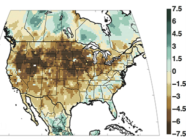
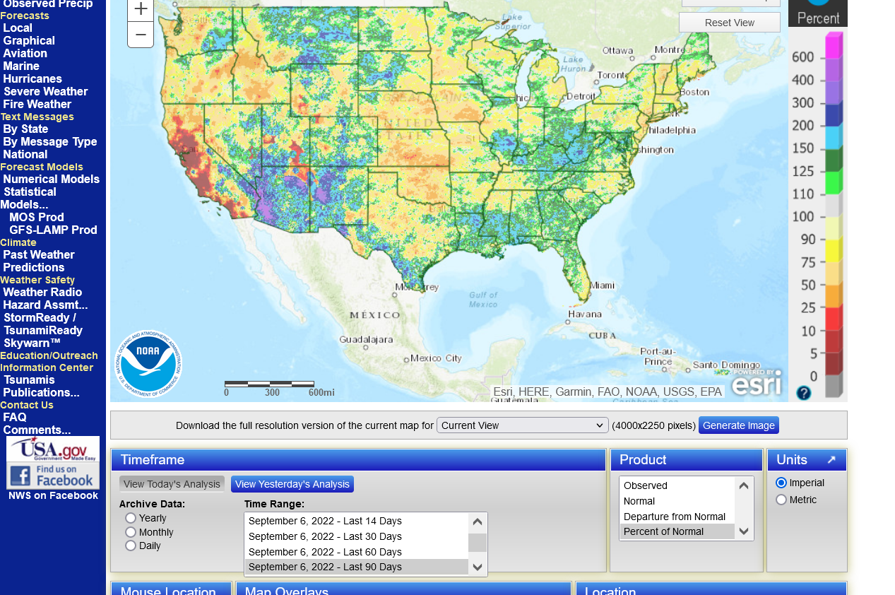
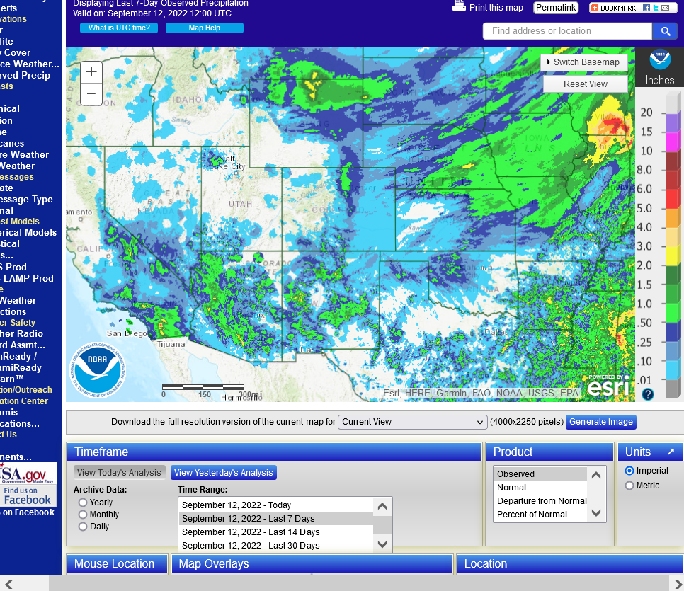
The map below is precip the last 90 days.
https://water.weather.gov/precip/
+++++++++++++++++++++++++++++++++++++++++++++++++++
This has greatly improved the extreme drought in many of these locations
For instance, all the D4, dark red in New Mexico and S.Nevada in early June...... is gone.
Large parts of Arizona are almost out of drought.
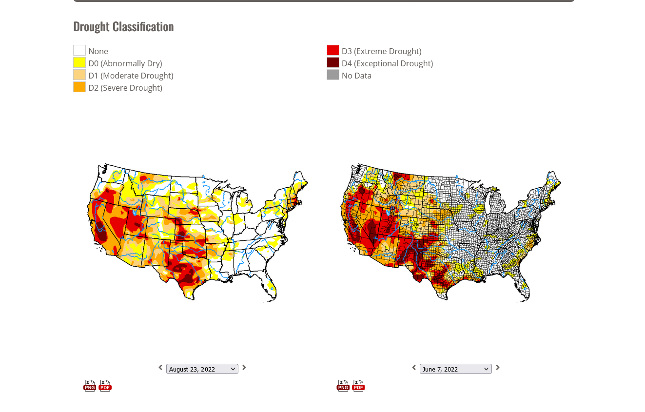
This is helping to reduce the water use/rate in the lower Colorado River Basin states of Arizona and far W.New Mexico..... for many places in those states.
However, it's not helping much to change the longer term extreme drop taking place at Lake Mead, which is in far southeast Nevada to across the Arizona border. I suspect the robust rains are lessening demand for Lake Mead water in areas of Arizona/far W.New Mexico but Summer rains don't result in runoff like melting snow does to feed the Colorado River, which in turns feeds into Lake Mead.....BUT THEY CAN HELP A BIT!
+++++++++++++++++++++++++++++++
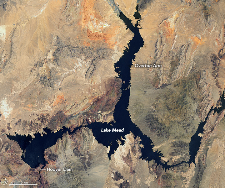
https://en.wikipedia.org/wiki/Lake_Mead
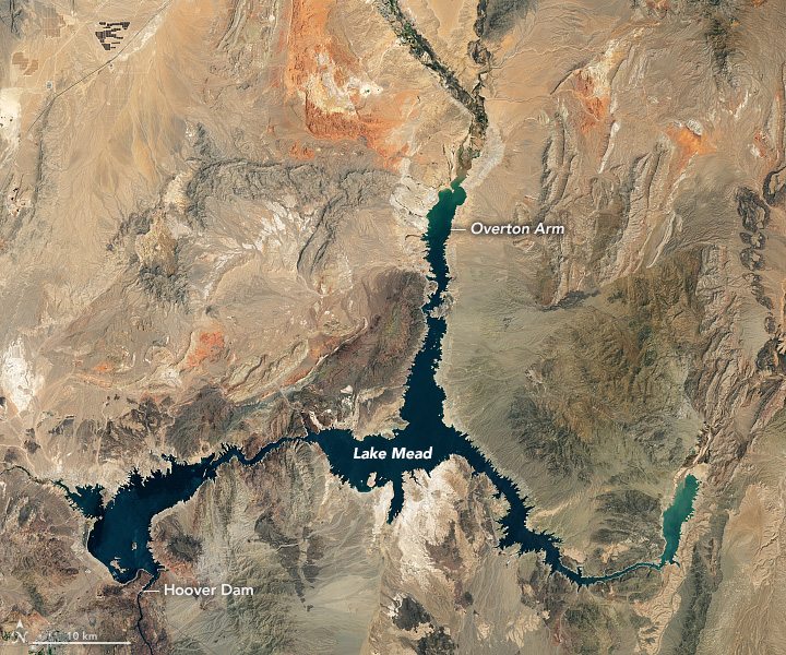
Lake Mead is a reservoir formed by the Hoover Dam on the Colorado River in the Southwestern United States. It is located in the states of Nevada and Arizona, 24 mi (39 km) east of Las Vegas. It is the largest reservoir in the US in terms of water capacity. Lake Mead provides water to the states of Arizona, California, and Nevada as well as some of Mexico, providing sustenance to nearly 20 million people and large areas of farmland.[1]
At maximum capacity, Lake Mead is 112 miles (180 km) long, 532 feet (162 m) at its greatest depth, has a surface elevation of 1,229 feet (375 m) above sea level, has a surface area of 247 square miles (640 km2), and contains 28.23 million acre-feet (34,820,000 megaliters) of water.
The lake has remained below full capacity since 1983 owing to drought and increased water demand.[2][3][4] As of May 31, 2022, Lake Mead held 26.63% of full capacity at 7.517 million acre-feet (9,272,000 megaliters), dropping below the reservoir's previous all-time low of 9.328 million acre-feet (11,506,000 megaliters) recorded in July 2016
https://arachnoid.com/NaturalResources/index.html
https://earthobservatory.nasa.gov/images/150111/lake-mead-keeps-dropping
July 6, 2000 July 3, 2022
++++++++++++++++++++++++++++++++++
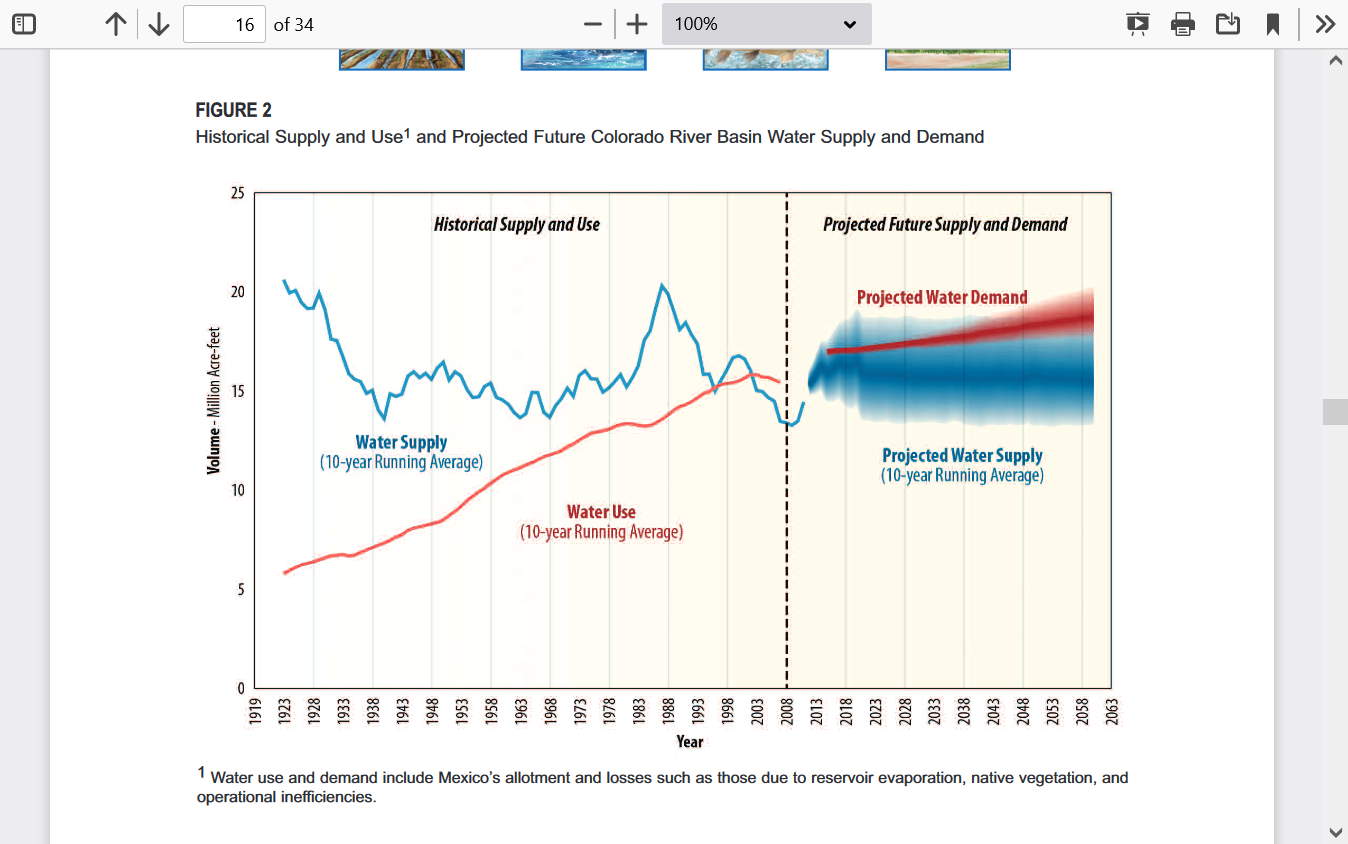
The chart below tells us that there is very little hope for long term precipitation to match the amount of water that people take out of Lake Meade to meet needs similar to what's dialed into demand dynamics using the balance sheet of today's world.
Too many people.............not enough water.
It's not like this isn't a desert!
https://www.usbr.gov/watersmart/bsp/docs/finalreport/ColoradoRiver/CRBS_Executive_Summary_FINAL.pdf
So the solution is to drastically lower the amount of water used by the massive number of people that have chosen to live in the desert.

https://www.lasvegasnevada.gov/News/Blog/Detail/lake-mead-water-shortage
On Aug. 16, 2022, the federal government declared a tier two water reduction on the Colorado River. This will limit the amount of water Southern Nevada will be allowed to withdraw from Lake Mead beginning in January 2023.
This comes one year after the federal government, prompted by the low water levels in Lake Mead, issued a water shortage declaration on the Colorado River. In January 2022, Southern Nevada’s water allocation was reduced by 7 billion gallons. Starting in January 2023, the allocation will be reduced by an additional 1.1 billion gallons for a total of 8.1 billion gallons. Our 2023 allocation will be 275,000 acre feet of water, 4,000 acre feet less than our 2022 allocation of 279,000.
However, there are several states that use this water and serious disagreements/issues revolving around the amount of cuts for each state/region.
It was just a year ago that the Department of the Interior declared the first shortage on the Colorado River -- a Tier 1. But the past 12 months did not bring enough rain and snow. Lake Mead's level has been around 1,040 feet this summer, just 27% of its full capacity.
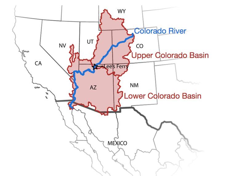
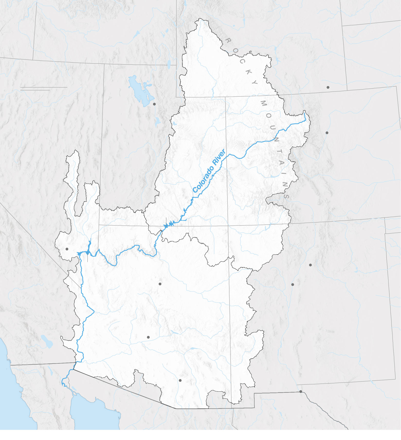
How the Colorado River’s water is divided
The Colorado River Basin is divided into two portions: an Upper and a Lower Basin, and each is allocated 7.5 million acre-feet of water per year, with Mexico receiving an additional 1.5 million acre-feet annually. Upper Basin states are entitled to a percentage of the Upper Basin’s overall water allocation. Meanwhile, Lower Basin states and Mexico are apportioned a set amount of water each year, and are subject to mandatory cuts as Lake Mead levels continue to drop.
Upper Basin 7.5 million acre-feet/year
Colorado 51.75%
Utah 23%
Wyoming 14%
New Mexico 11.25%
Lower Basin 7.5 million acre-feet/year
California 4.4M =59%
Arizona 2.8M =37%
Nevada 300K =4%
+Mexico 1.5M
Total use = 16.5 million acre-feet/year
The main reason for the dryness during the past 3 years is the long lived La Nina. La Nina's change the course of winds and weather systems downstream. The closer to the La Nina, usually the stronger the impact.
La Nina's correlate strongly to persistent upper level high pressure domes in the West that, at times can shift farther east into the Plains and Midwest.
The last 2 widespread, major droughts in the Midwest were caused by the La Nina's in 2012 and 1988. The record long period in between those droughts (24 years) represented the best crop growing weather in recorded history for this extremely high producing region. This has been part of the climate change that we never read about.
La Nina's feature COOL/NEGATIVE water temperature anomalies in the E/C tropical Pacific Ocean. They are NOT caused by global warming!
I'd be willing to bet my house that when we have our next major El Nino, the precipitation out West will increase and likely help ease the drought in the West and increase levels on Lake Meade, especially if water use cuts are maintained for awhile and ESPECIALLY if we had an EL Nino that lasted thru 2 Winters.
However, it's very difficult to have El Nino's especially a long lived El Nino when the PDO is solidly negative as it is right now. +PDO correlates strongly with El Ninos(warm temp anomalies in the E/C tropical Pacific) and favorable weather in the US growing season/less drought.
-PDO, like we have now correlates strongly with La Nina's, just like the current one, now lasting the longest of any La Nina in the last 2 decades.
https://www.ncei.noaa.gov/access/monitoring/pdo/%20National%20Centers%20for%20Environmental%20Information%20(NCEI).png)
However, cuts in demand will likely be required for most of the future because there are just too many people living in the desert.
It turned into the current desert from many centuries to thousands of years of droughts like we are experiencing right now. Climate change or no climate change.
The driest decade in our country's history of accurate records, by a wide margin was the Dust Bowl, 1930's. Easily the most heat waves that year.
https://www.marketforum.com/forum/topic/87422/
https://www.marketforum.com/forum/topic/56668/#56673
https://www.marketforum.com/forum/topic/67004/

+++++++++++++++
https://www.marketforum.com/forum/topic/87422/#87425

Climate change has certainly warmed the planet by almost 1 deg. C since then, which increases evaporation. However, it has not increased drought significantly and there is great disagreement on what the change in precipitation might look like in this area of the West for the next century.
Maybe we can take heart in the fact that busted global climate models, that have been wrong, are forecasting MORE rain for California during the next century(though it would make sense with more El Ninos)
https://phys.org/news/2017-07-california-wetter-century.html
Read more at: https://phys.org/news ...
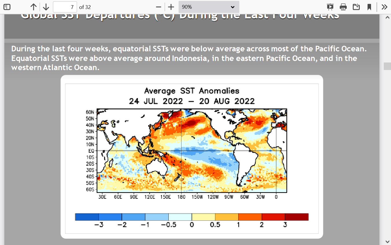
Here's the latest on this current, extremely long lived, drought causing La NIna. There it is in the blue color on the map below.
ENSO: Recent Evolution,
Current Status and Predictions
++++++++++++++++++++++++++++++++++++++++++++++++++++++++++++++++++++
Notice how the pattern above is not a perfect, classical -PDO below but still features the big warm anomalies north and cold anomalies south.
https://legacy.climate.ncsu.edu/climate/patterns/pdo

++++++++++++++++++++++++++++++++++++++++++
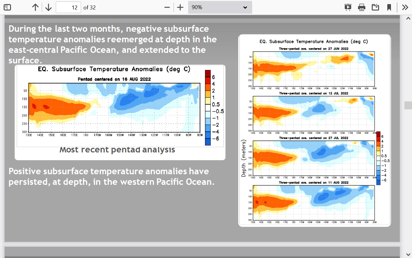
Back to this current La Nina:
Holy Cow! Cold water anomalies have been reemerging again below the surface! This La Nina just won't Die.
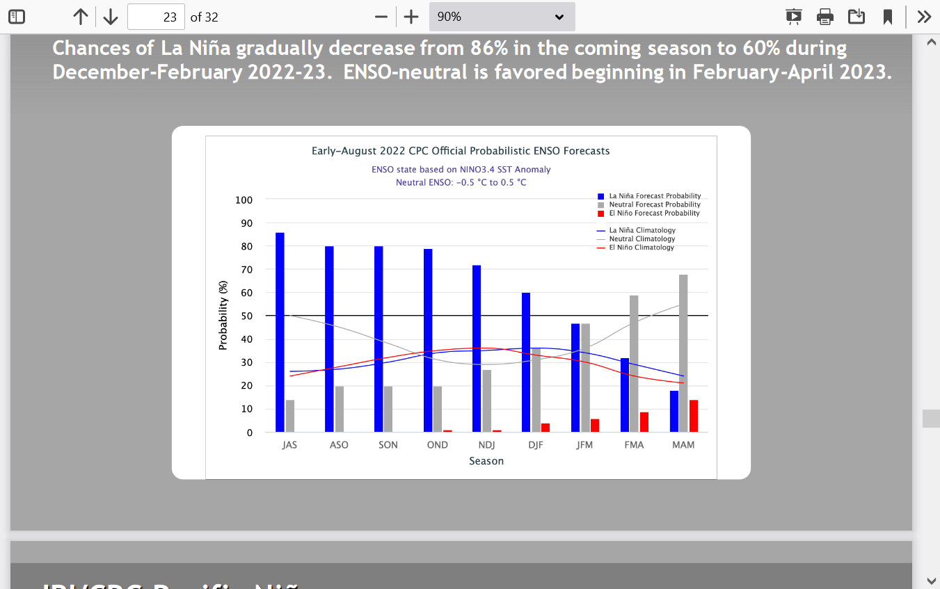
Here's the latest forecast based on models that have killed the La Nina too early for the past year now.
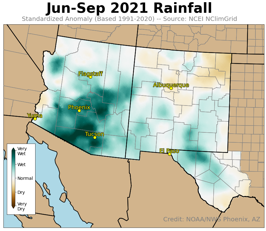
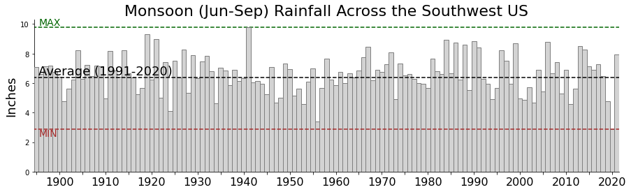
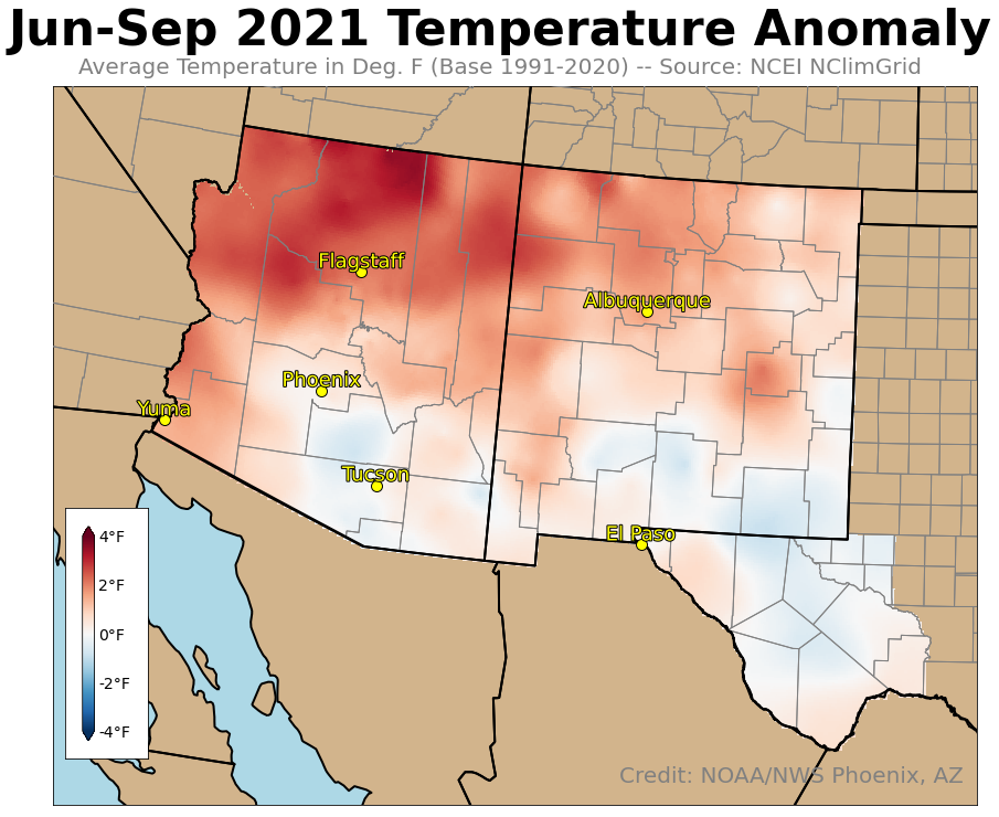
Last year, the Southwest Monsoon featured a pretty wet season, after 2020 was the driest in the last century.
Review of the 2021 Monsoon Across the Southwest U.S.
Compiled by NOAA/NWS Phoenix, AZ. Published Nov. 23, 2021
https://www.weather.gov/psr/2021MonsoonReview
+++++++++++++++++++++++++++++++++++++++
Despite the wetter than average season, temperatures were hotter than average, especially in the northern areas of these states. This was related to the La Nina. Cool water anomalies in the tropical Pacific changing the circulation of air downstream, resulting in a strong tendency for upper level heat ridges to form and remain for long periods in the Western US and points eastward to the Midwest at times.
So:
With the cold water in the pacific under the surface
would it be reasonable to expect a repeat of dry weather in the western corn belt??? for 2023, much the same as 2022
What about SA weather???
I am not educated in weather patterns, even though you did a good job of explaining
I am just not up to the task
Even with all your hard work explaining things
I must ask a simple question of what to expect in 2023 even with all the variables that make such a question almost impossible to answer
For 2022 the guys out west have been telling us the crop is not average and the eastern guys have said the crop is not average
PF tour is the 1st look at the crop and now we are asking how much faith do you put in a small sample of the corn belt
PF is telling us the crop is below USDA spring expectations
I suppose some body has to take one or two for the team
We are in the eastern part of the corn belt
2021 and 2022 have not been very kind to our yields
2021 we suffered a monsoon of over 5" of rain in a short time period during June, too late to replant, but did drown out significant acreage
We find re planting does not pay on our farm no matter what
Our soil topography profile is relatively flat with some lower spots which collected the rain water and drowned out the crop
We are tiled to remove 1 1/2" of water in 24 hrs
5" was more than the tile could handle, even with some new tile runs spaced at 20'
Our soil and drainage can not handle such a large quantity of rain in a short time period, thus some crop loss in 2021
We are now into 2022 and suffered a drought plus high heat prior to pollination We pollinated okay with very few problems
However, some corn stopped growing until we got rain
Our entire region looks very uneven with small cobs on the small corn plants
We have some very good corn and some very poor, with the average expected to be below average, even though a dry yr will surprise with more than expected
We expect our yield to be 20 bu less than expected during last spring planting season, which, for us was a very small planting window but our crop was planted in a timely time frame, thanks to a larger corn planter
Plus two dedicated sweet corn planters and a bean planter
Every thing was good until the rain stopped
At least not having crop insurance did not hurt us as the premium would not have paid for the lost production in our canadian style insurance plan
Wish we had american crop insurance plans
Not enough people to pay taxes to support the kind of insurance we should have
We can't just print up a boat load of currency, out of thin air, or our dollar would tank badly
Our currency pool is too small, to be printing currency from thin air
So: We farm with out crop insurance
In 50 yrs our farm would have had two insurance claims, neither of which would have paid the premium cost
Plus 48 yrs of premium cost with no claims
Both of our crop losses were hail storms, with some crop salvaged after the hail, which meant the crop loss was smaller than a total loss
Even a partial hail claim would not have paid the premium cost, so we farm with no crop insurance
In this part of the world, we always harvest a crop with hail as our major crop threat or too much or not enough water which causes below average crops But we do harvest a crop every yr Usually enough to pay the input bills and some left over for living expenses
If not this yr there is always next yr
Although we do not carry crop insurance, We carry insurance on large items and heavy liability insurance, any thing which would put a heavy dent on our bank acct
The insurance Co wants us to carry 500,000 plus on our family house
This seems fair, as we carry replacement cost, but to have to insure contents for 50% of house value seems a bit much as we don't have 250,000 of contents I took pictures of all our contents and can not come close to 250,000, but just in case the insurance Co wants proof of contents
That is just the way all home insurance works in this part of the world, with the 50 % replacement contents clause and premium
Trust me we have checked out different insurance Co and their policies
Things are probably different in your part of the world
Just thought I would explain our part of the world, not that I would expect you to be very interested
How we manage risk and other things
In the end all we all want is to make a comfortable living
Which sort of makes us all the same
Thanks much, Wayne!
La Nina/El Nino's take many months to change, so we have high confidence that La Nina will continue thru the rest of 2022.
Next year is another deal. For the past year, the models have been trying to kill the La Nina and going to neutral. This would be good for improving the droughts caused from La Nina........when it happens.
By the start of next Spring, the VAST majority of models are in neutral (nadda) territory. For the La Nina to continue beyond this would make it close to the longest in history. April 1973 to April 1976 (near the end of 3 decades of modest global cooling) is the longest since we've measured it.
We are in a very stout -PDO. Not expecting the implications to be clear to non meteorologists but just know that this particular decades long regime features more La Nina's and less El Nino's.
However, we may be near the end of the current -PDO regime.
That's not giving your brain anything to chew on if you're not an atmospheric science guy but let's just say in the current regime, it will be very tough to generate El Ninos, which are usually the best for growing season weather and Winter precipitation in the West.
https://bouldercityreview.com/news/mother-nature-lends-a-foot-lakes-level-rises-70896/
By Marvin Clemons Special to the Boulder City Review
August 17, 2022 - 3:14 pm
The wettest Las Vegas Valley monsoon season in a decade likely isn’t the only reason behind it, but Lake Mead has risen just over 18 inches during recent area rainfall.
As of 10:30 a.m. Wednesday, the lake was at 1,042.44 feet in elevation.
On July 27, about the time rainfall became a nearly daily event in the area, the lake elevation was 1,040.71 feet — which is also the low point for the lake so far this year. Some downpours exceeded a half inch in 10 minutes
Harry Reid International Airport has received 1.08 inches so far this monsoon season with several areas of the valley receiving considerably more. Between July 27 through Aug. 12, Boulder City received .87 inches of rain.
Rainfall that doesn’t soak into the ground usually finds its way through the Las Vegas Wash to the lake, Southern Nevada Water Authority spokesman Bronson Mack said after the first summer storm in late July.
The rise of 1.73 feet is also the only rise during the summer in at least three years. During summer months the lake level typically declines a foot or two. Winter snowpack on the western slope of the Rocky Mountains is, of course, the biggest factor in the amount of water that flows into Lake Powell and Lake Mead.
Bureau of Reclamation projections have indicated the lake level at Hoover Dam will decline at least 20 feet by the end of the year.
Lake Mead is the source of 90 percent of Southern Nevada’s drinking water, the other 10 percent coming from groundwater.
The nation’s largest reservoir has fallen about 170 feet since the drought began in 2000 and sits at 27 percent capacity, according to the Bureau of Reclamation.
The recent heavy rains, however, have reduced drought levels in Southern Nevada and much of the Southwest.
“Most locales in Arizona, New Mexico, the California deserts, Southern Nevada, and a few other scattered areas have measured at least 200 percent of normal (rainfall) over the past two months,” the U.S. Drought Monitor said in a report issued Aug. 11.
As a result, the “exceptional drought” area in Nevada dropped from nearly 30 percent a week ago to 4 percent on Aug. 11, its lowest point in nearly two years, the report said.
Boulder City is likely to get more rain through the summer monsoon season, which ends Sept. 30. Accuweather is forecasting afternoon thunderstorms for the majority of the next seven days.
just a few observations from a local...
the monsoon has mostly been good in southern arizona. but not so good in northern arizona.
the official numbers for rain at the Tucson airport is not that great for this summer, but most other places around southern arizona look like above normal rain.
good rains in southern AZ do nothing for the lakes up north. but it does help with water tables in the southern part of the state.
for us locally this is not as big of an issue.
the BIG issue is once the water level in the lakes get low enough to effect power generation.
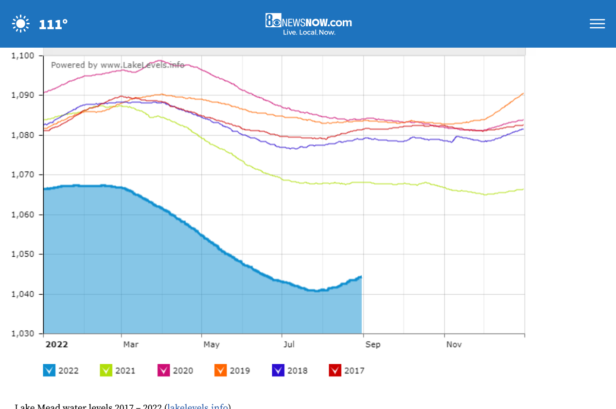
They’re ready to cruise as water levels continue to rise. The latest recording showed the lake is now 1,044 feet above sea level. That’s 4 feet higher than the lowest recorded point in July
https://www.8newsnow.com/news/local-news/why-lake-mead-continues-to-rise-while-lake-powell-falls/
The Bureau of Reclamation (BOR) — which oversees water distribution and collection along the Colorado River basin – told 8 News Now the rise was due to the increase in rainfall from the monsoonal flow and decreased demand from downstream partners (states).
We now know that, according to the BOR, 64% of the lake level rise this past month has come from rain runoff and the other 36% from decreased downstream demand.
Rainfall the last 90 days below. Robust Summer Monsoon rains in the Southwest, especially AZ and NM!
https://water.weather.gov/precip/
Hurricane Kay will weaken but on the outer northeast fringe, send some rains into the the Southwest. Far S.California could get a couple of inches.
https://www.nhc.noaa.gov/refresh/graphics_ep2+shtml/235716.shtml?cone#contents

https://www.marketforum.com/forum/topic/83844/#83848
7 Day Total precipitation below:
http://www.wpc.ncep.noaa.govcdx /qpf/p168i.gif?1530796126

For perspective, that's San Diego in the on the left, towards the bottom. Phoenix is barely in the green, to the far right of that.
Fairly high risk of some flooding in the red/pink.
They will be glad to get more rain, especially any that gets into California.
Soil moisture in AZ and NM to se.NV and sw.CO is actually pretty good right now thanks to the robust monsoon, which was a big reason to start this thread..........that has caused Lake Mead levels to increase around 4 feet from the bottom in July.
https://www.cpc.ncep.noaa.gov/products/Soilmst_Monitoring/US/Soilmst/Soilmst.shtml#
![]()
ABC nightly news just now covered the rains out West as totally harmful.
Mudslides, flash flooding and so on. Showing video of cars driving with water running over the road......dangerous driving and telling us that scientists tell us that climate change which caused this historic drought and heat also caused the flash flooding and mudslides from these "extreme rains".
Their meteorologist did a closing shot in front of a bulldozer that was pushing mud in a remote location and talking about the damage from extreme rains.
Just before that, they interviewed a resident of S.California and asked her for a comment "this is great and we hope it keeps on coming!" was the response.
These dishonest people in the media are a trip! Anybody with a few objective brain cells would be agreeing with the residents about the wonderful rains falling over some very dry areas.......instead of twisting something good into being something bad to match their climate crisis narrative.
Total rains the past 7 days below:
A lot of great information there Mike. I look forward to spending some time tonight reading over it. It is nice to see the South West getting some rain.
Thanks much Jim!
CNN was doing the same thing a few days ago:
https://www.cnn.com/2022/09/10/weather/kay-storms-california-wildfires-saturday/index.html
CNN's take: (nothing good about rains in a drought)
As parts of the West grapple with destructive wildfires fueled by scorching temperatures, a storm that brought life-threatening flash flooding and powerful winds to Southern California on Friday will deliver more heavy rain over the weekend.
At least 5 million residents across California, Nevada and Arizona remain under flood watches through Saturday morning as post-tropical cyclone Kay drenches the coastline and further inland. An additional half inch of rain is forecast for the region Saturday.
San Diego County saw some of the heaviest rain totals Friday, with 5.08 inches on Mount Laguna and 4.61 inches in Ranchita, according to preliminary data from the National Weather Service. The city received 0.61 inches of rain Friday, shattering its previous daily rainfall record of 0.09 inches set in 1976. The storm also caused some damage and flooded roads, officials said.
Kay will “continue to bring heavy rain and flash flooding to portions of the Desert Southwest into Southern California” through Saturday, the National Weather Service said.
The downgraded storm system still has measured sustained winds of 40 mph, which had worried fire officials as the erratic Fairview Fire raged in Southern California. The fire has charred more than 28,000 acres since it started September 5, according to Cal Fire on Saturday.
On Saturday, three people were injured after a helicopter assigned to the Fairview Fire crashed while attempting to land at a local airport.
The Bell 206 helicopter crashed in a residential backyard while on approach to Banning Municipal Airport. according to the Federal Aviation Administration. Banning is located about 85 miles east of Los Angeles.
The three people onboard the helicopter when it crashed were a pilot and two fire personnel, according to a statement from Cal Fire. All three were taken to an area trauma center for further treatment and evaluation. "
++++++++++++++++++++
metmike: OK, let's see what actual experts(real person) living out there stated, buried way down in the story to get their take on this extreme weather causing damaging winds, dangerous mudslides and life threatening flash flooding rain:
“With the onset of the rain, the drought-stricken area has not only received much-needed precipitation, but has also aided firefighters by slowing the spread of the Fairview Fire,” Cal Fire saidFriday."
