Get all the comprehensive weather here:
https://www.marketforum.com/forum/topic/83844/
++++++++++++
Previous thread:
Rain/drought thread April/May 2026
Started by metmike - April 20, 2026, 10:35 a.m.
The way to use these maps below is to just scroll thru them to see the changes with time. Weather markets trade on CHANGES compared to the previous weather forecasts. It also helps to forecast by identifying TRENDS!
The last map in the series ALWAYS gets the most weighting. Compare it with previous maps above it for perspective!
Do consider that as the calendar page turns, rains that just fell will come out of the updated forecast as another day is added at the end of the forecast. A huge rain that just fell(that was in the forecast yesterday) can make the latest forecast look much drier than it really is.
This map is updated 2 times a day, automatically:
5-4-26: Moderate/Heavy rains Ohio/Tennessee Valley's and south of that. Dry northwest 2\3rds of the Cornbelt which may be the new pattern for May?
5-5-26: Added a bit to rain totals. HEAVY in South.
5-6-26: Heavy, welcome rains DEEP south. PM: added moderate rains farther north to Ohio Valley to Eastern/Southern Midwest.
5-7-26: Moderate/Heavy, welcome rains along the Gulf Coast. Modest rains Ohio Valley, southwestward. Mostly dry in most of the Cornbelt.
5-8-26: Similar to yesterday.
5-9-26: Mostly dry in most places except the Gulf Coast. PM update. Rains increasing TX/OK.
5-10-26: Week 1 rains starting to increase a bit.
5-11-26: Rains picking up even more in the central US......as expected.
5-12/13-26: Rains picking up in the central US, along with BRIEF heat-bearish grains
5-14-26: Rains expanding more in the central US/Cornbelt. BEARISH grains!
5-15-26: Robust rains coming for key production areas week 1. BEARISH grains.
5-16-26 PM: Good rains days 1-4 North. Then good rains move straight south days 5--7(North dries out).
5-17-26 Rains going down north and up south. Especially heavy TX/AR/LA.
5-18-26: Rains continue to go down north(some has fallen) and way up FAR south. TX/LA/AR could see flooding.
5-19-26: Mostly dry northern Midwest/Plains. Wet far southeast belt to East Coast. Very wet TX/LA/AR.
5-20-26: Mostly dry Upper Midwest(more rain for C/S Plains on some models-not enough to help HRW??). Very wet South to East making a big dent in the drought.
5-21-26: Mostly dry Midwest(some rain Plains). VERY wet South.
5-22-26: Mostly dry Midwest(some rains in N and S Plains) Very wet South.
5-23-26: DRY Midwest, Very wet South
5-24-26: DRY Midwest, wet south.
5-25-26: DRY Midwest, wet South. This is week 1 and we can see from above, how long that we've known about it. Week 2 below is going to be the most likely place for where changes come first! Today, they look bullish(drier).
5-26-26: DRY Midwest, WET South. NEW rains S.Plains.
5-27-26: DRY Midwest. Rains South to S/C.Plains, including HRW areas(too late to help the crop much?)
5-28-26: Same as yesterday with rains in the Plains increasing northward(on the back side of high pressure)
5-29-26: Rains returning to WCB (N.Plains) on the backside of the high. PM-Rains continue to increase(CCB?)
5-30-26: Rains continue to return on the back side of the high into the WCB and CCB.
5-31-26: Rains continue to creep eastward with time in the CCB as day 8 on Saturday is day 7 Sunday.
7 Day Total precipitation below:
http://www.wpc.ncep.noaa.govcdx /qpf/p168i.gif?1530796126

+++++++++++++++++++++++++++++++
Below is the GEFS solution, Day 15 500 mb map+ Day 15 temps + rain anomalies FOR WEEK 2 ONLY!
Using 3 maps now below:
5-9-26: 12z May 25. Strong ridge in the center of the country+ May 25 temps. Week 2 rains returning.
5-10-26: 12z May 26. Slightly more amplified compared to yesterday. Rains returning JUST week 2 forecast.
5-11-26: Cooler Midwest. Slightly drier.
5-13-26: May 28 map for 500mb. (ridge center) week 2 temps(hot Plains) week 2 rains(average to above)
5-14-26: 6z solution: May 29 maps: Similar to yesterday except MUCH more week 2 rains south, where we need it most.
5-15-26: 6z solution May 30. Upper level ridge builds into the Plains in week 2 with HEAT in the West shifting to the Plains! Dry north/WET south. Potentially turning bullish if it lasts into June.
5-16-26: June 1: Ridge in the center with HEAT into the Plains spreading to WCB/Upper Midwest. Dry north/wet South in week 2.
5-17-26: 12 run for June 2: HEAT ridge and widespread week 2 heat! Week 2 rains: WET! south, DRY northwest Cornbelt/N.Plains.
5-18-26: 6z run for June 3: Heat ridge,hot and dry West to Upper Midwest. Wet South.
5-19-26: 6z for June 4: Heat ridge, HOT/Dry Plains westward. Dry Midwest. Wet South.
5-20-26: 6z for June 5 Heat ridge Plains. Dry-ish West to Upper Midwest. Wet South.
5-21-26: 6z for June 5. Heat ridge Rockies/Plains. Dry Midwest. CORRECTION to take out rains South!!
5-22-26: 6z for June 6. Heat ridge Rockies/Plains. Even drier Midwest(a bit bullish?). MUCH cooler OK rains South.
5-23-26: 12z for June 7: Week 2=HOT-West to N.Plains to Upper Midwest. DRY Plains/Midwest. More bullish!
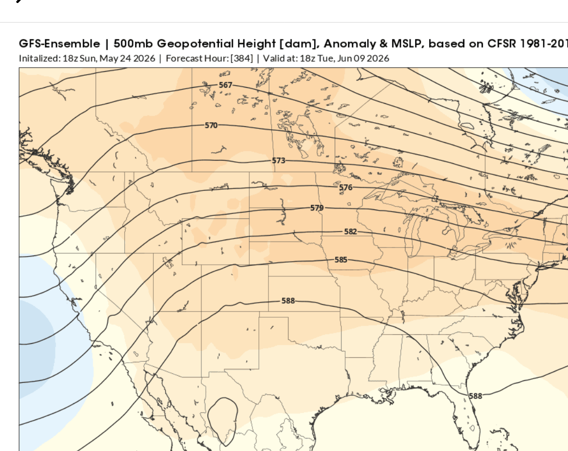
5-24-26: 18z for June 8: Week 2-HOT West to Plains to Upper Midwest. Mild Southeast. Dry everywhere. More bullish!
5-25-26: 12z for June 10: HEAT RIDGE RETROGRADES WEST vs yesterday!!! HOT West to Upper Midwest. Wet SE.
5-26-26: Heat RIDGE BACK IN PLAINS.
5-27-26: 6z for June 12: Still BULLISH! Not much change.
5-28-26; 18z for June 13. 500 mb high is weaker. Not as dry but still a bit bullish(HOT! Plains/WCB)
5-29-26: 6z for June 14. 500 mb shifts east. HOT Midsection! Not as dry(week 2 rains)!
5-30-26: 12z for week 2(June 5) HOT West to Plains. Drier north than European model. Wet South.
5-31-26: Not as hot Midwest


Below is the European Ensemble model solution. WEEK 2 RAIN ANOMALIES.
Using 3 maps now:
5-9-26: 12z EE: 500 mb May 24. Temp anomalies May 24. Week 2 RAINS RETURNING!
5-10-26: 12z EE 500 mb ridge not as strong as GEFS. Plains heat. MUCH wetter than GEFS.
5-11-26: Cooler and drier Midwest.
5-13-26: Wettish Midwest
5-14-26:0z May 27 map. Week 2 rains MUCH MORE in the South. Less north.
5-15-26: 0z run. May 28 maps. Strong upper level ridge shifting to Midwest. Dry with HEAT moving into the Plains, Upper Midwest late. WET and coolish South!!!
5-16-26: May 30. Ridging with the greatest anomalies north. Hot and dry-ish N.Plains/Upper Midwest to WCB. WET and mild across the South, across the East and back to the far ECB.
5-17-26: Oz run: Heat and ridging West to Upper Midwest. VERY WET South!!
5-18-26: 0z run for june 2: Week 2 temps/rain. HOT and DRY North. WET south!!!
5-19-26:0z run for June 3-500 mb map: Week 2 temps=HOT and DRY North. Wet South!!!!
5-20-26: Oz run for June 3. 500 mb ridge anomalies slightly weaker today. Still hot/dry north, wet south. A bit more rain in the Plains today. Is the pattern breaking down at the end of week 2????
5-22-26: 0Z run for June 5. 500 mb ridge-northern tier. Dry entire Midwest. Hot West to N.Plains. More bullish!
5-23-26: 12z run June 7. 500 mb ridge weakening. Dry entire Midwest. Hot West to N/Plains. Wet (cool) far SE.
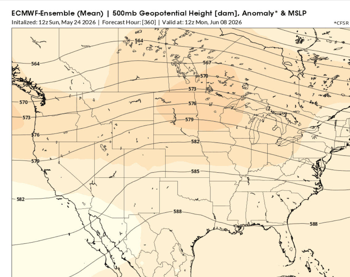
5-24-26: 12z run for June 8. Widespread modest ridge. Hot West to N.Plains to Upper Midwest. DRY Midwest. Wet/cool Deep South.
5-25-26: 500 mb ridge MUCH Stronger. HOT West to Upper Midwest. Dry most places. BULLISH. Wet far SE.
5-26-26: 500 mb ridge even Stronger. HOTTER and DRIER. MORE BULLISH!!!
5-27-26: : Weaker heat ridge. Rains returning late week 2. LESS bullish!
5-28-26: Less ridging, more zonal but still HOT! Midwest rains returning to average! Wet South! Not as bullish!
5-29-26: 0z: HEAT dominates, HOWEVER, Midwest rains returning from the south. Wet South!!! Turning LESS bullish(more bearish)! 12Z run after the market close was DRIER!
5-30-26: Heat ridge flattens. June 14 map. Heat spreads east. Week 2 is wetter than GEFS!
5-31-26: More zonal flow. June 16 map.


Below is the 46 day European Ensemble model, temperature/500 mb heights.
NEW MAPS: European Ensemble 500 mb map day 46. Week 6 temps(7 days) + Rain anomaly days 16-46(weeks 3-4-5-6)
5-6-26: 3rd week in June. Heat ridge Southern Plains. Storms northeast/east. Ring of fire?
5-7-26: June 21st heat ridge position. Temps the previous week. HOT West to the Plains!!!
5-8-26: June 22nd S.Plains Heat Ridge expands northwest to east!
5-9-26: June 23rd. Hot, capped dome S to C Plains. Record heat there. Heat spreads north(west) of that.Ring of fire, active storm making perturbations around the periphery.
5-10-26: June 24th. Extremely similar to yesterday! Turning wet east of the Plains.
5-11-26: June 25th. Very similar to the previous 2 days!
5-13-26: june 26th. Heat ridge Southern Plains. Week 6 temps-HOT Plains-westward! Dry/capped Plains-wet east of that(ring of fire storms?
5-14-26: June 27th. Heat ridge WEAKER! Cooler Midwest with more rains. Less dry in the Plains! BEARISH!
5-15-26: June 29th. Heat ridge stronger. Slightly warmer and drier vs yesterday but the HOT/DRY is still West to Plains.
5-16-26: June 30. Impressive, widespread heat ridge. Hottest and driest west of the Mississippi. Better potential for good rains east of that, with less heat.
5-17-26: July 1 heat ridge. HOT West to Plains and dry(week 6 temps). Wet to the east of that(30 day rains).
5-18-26: July 2 heat ridge. Hot West to Plains. Dry S/C Plains under the ridge. Potentially wet elsewhere(30 day rains for June). Pretty BEARISH grains!
5-19-26: July 3 heat ridge. HOT/DRY Plains(westward). Wet/bearish east of that.
5-20-26: July 4 heat ridge: HOT/DRY Plains westward. Wet/bearish still east of that.
5-21-26: July 5 heat ridge: Hot/Dry c/s Plains westward. Wet/bearish everywhere else!
5-22-26: July 6 heat ridge: Hotter/drier Upper Midwest(bullish??). Bearish Eastern Cornbelt/Southeast.
5-23-26: July 7 HEAT RIDGE a bit Stronger: HOT/DRY West to Plains to Upper Midwest. Wet east of that.
5-24-26:July 8 Heat Ridge. HOT/DRY West to Plains to WCB. Wet east of that.
5-25-26: July 10 Heat Ridge. 500 mb-588 contour is 100 miles farther north vs yesterday. HOT AND DRY, West to Plains to WCB and now CCB. Eastern 1/3 of the US mild with rains. BULLISH!
5-26-26: July 11 HEAT Ridge tiny bit weaker. HOT and dry West to Plains but not quite AS dry with some rains late. Eastern 1/3rd still mild with rains. Not AS bullish but still bullish.
5-27-26: July 12. HUGE heat ridge. Hot/dry West to Plains to WCB. Could be a ring of fire pattern with storm clusters on the periphery of the heat ridge that dump rains in the ECB after they come over the top of the capped dome.
5-28-26: Pretty similar to yesterday. Still "potentially" bullish because of the size of the heat ridge!
5-29-26: HUGE heat ridge. HOT midsection. Ring of fire storm clusters around and east of heat ridge?
5-31-26: Not much change!


GEFS +500 mb map on day 35. Temps for week 5 (days 28-35). Rain anomaly days 5-35.
5-6-26: Wet east of the Mississippi. Dry Plains. Upper level heat ridge building in the Plains, June 10th position,ring of fire perturbations over the top and storms east?
5-7-26: 30 day anomaly thru June 10. Drier than the EE. Heat ridge S.Plains. Shutting down rains there.
5-9-26: June 12 Heat ridge. Week 5 temps. 30 day rains thru June 12-pretty dry.
5-10-26: June 13 ridge farther east than EE. Week 5 heat farther east. Rains increasing from yesterday but still MUCH LESS rain than the EE!!
5-11-26-: Much weaker ridge. MUCH cooler Midwest vs yesterday. MUCH drier/ not as wet as the European model.
5-13-26: Big Ridge June 15 and heat thru much of the country during week 5. 30 day rains ending June 15. MUCH wetter than previous forecasts! Very BEARISH grains!
5-14-26: Heat ridge backed up with dry corridor far northwest Cornbelt. The rest of the belt sees northwest flow over the top and around the heat ridge with active storm inducing,perturbations.
5-15-26: June 18 heat ridge building more. HOT temps June 11-18. Total rain anomalies ending June 18=UNCERTAIN!
5-16-26: June 19 Heat ridge with intense heat West to Plains.
5-17-26: June 20 HEAT ridge with intense heat West to Plains and dry. Mostly dry too, northwestern 1/2+ Cornbelt. Wet South.
5-19-26: June 22 MAJOR HEAT ridge with some extreme weather: Dry northwest belt and westward. Very wet southern and eastern US. Extreme weather like this is usually not great for the crops.
5-20-26: For June 23 500 mb map: June 16-23 temps: Hot West to Plains. 30 day rains:Dry Upper Midwest. Wet South.
5:22-26- For June 25: Hot/Dry West to Plains into WCB. June 18-25 temps. 30 day rains ending June 25. Dry N.Plains/Upper Midwest. Wet S/Se!
5-24-26: For June 27: STRONGER 500 mb ridge. HOT/DRY Plains to WCB. DRY Midwest=BULLISH! Wet Southeast.
5-25-26: June 28 ridge position. June 21-28 temps. 30 day rains ending June 28. Similar to yesterday. The forecast turns wetter in the 2nd half of June but that's LOW SKILL.
5-26-26: June 29. Similar to yesterday but slightly hotter and drier and MORE bullish.
5-28-26: July 1. Pretty hot/dry and bullish.
5-29-26: July 3. Hot with MUCH more rain than yesterday. 1 week temps. 30 day rains ending 7-3. RING OF FIRE storms with active, heavy rain storm clusters around and especially east of the heat ridge.


Maps below updated thru 5-28.
Re: Re: Re: Re: Re: Weather May 2022
By metmike - April 30, 2022, 8:46 p.m.
+++++++++
Much of the Midwest and Great Lakes had their soil moisture recharged in April. Now much of the South saw the drought intensity greatly reduced in May.
+++++++++
Soilmoisture anomaly:
These maps sometimes take a day to catch up to incorporate the latest data(the bottom map is only updated once a week).
https://www.cpc.ncep.noaa.gov/products/Soilmst_Monitoring/US/Soilmst/Soilmst.shtml#
![]()


++++++++++++++++++++++++++++
Main link:
https://mrcc.purdue.edu/ag-climate-dashboard
Updated daily below:
https://mrcc.purdue.edu/cliwatch/watch.htm#curMonths
Snapshot below:

NEW LINK:
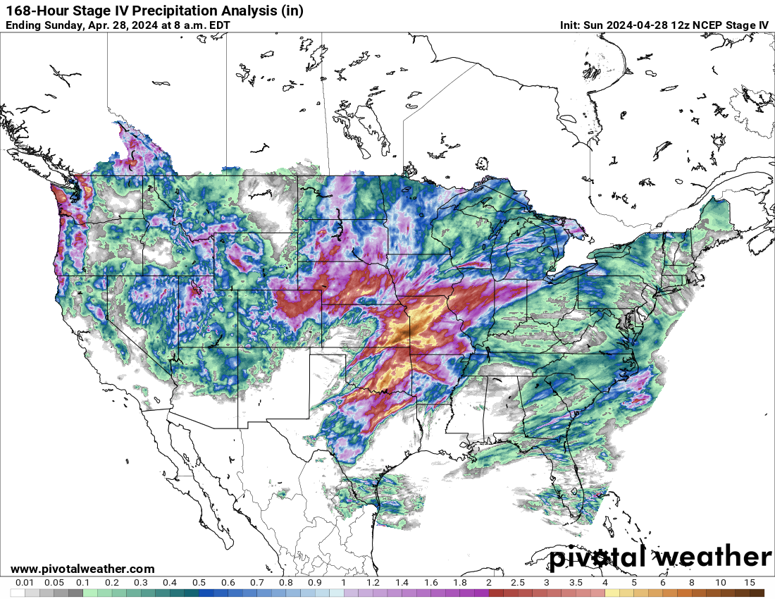
https://www.pivotalweather.com/maps.php?ds=stageiv&p=stageiv_qpe_168h_p&r=conus
Last 24 hours
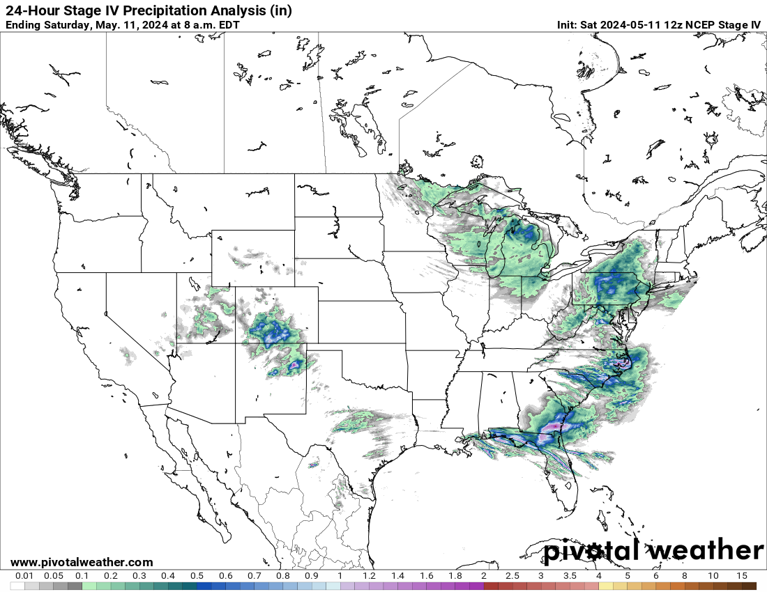
Last 72 hours
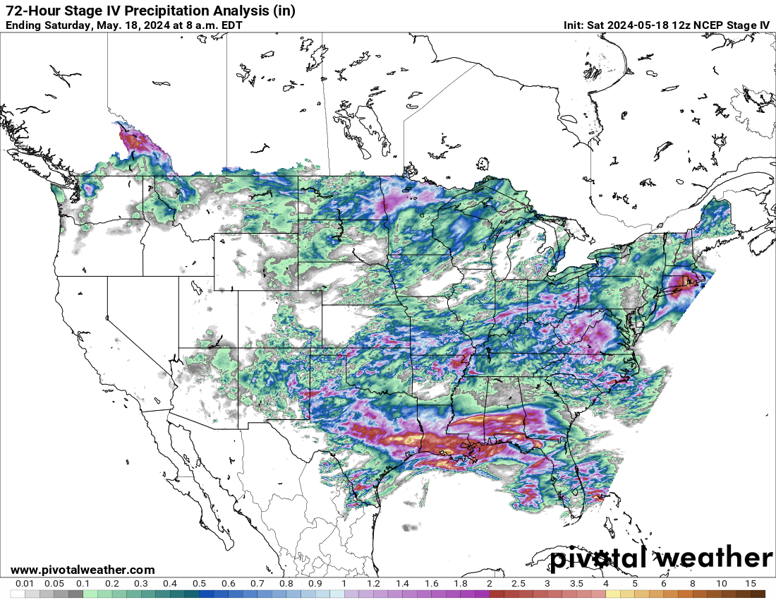
Last 7 days:
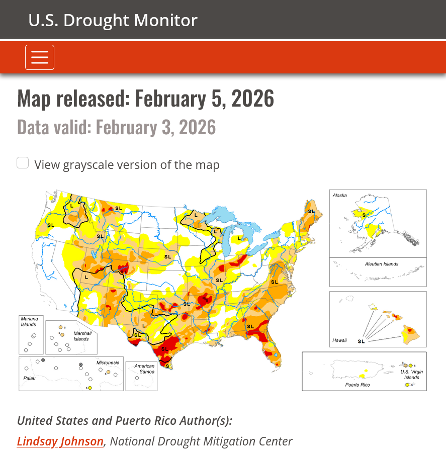
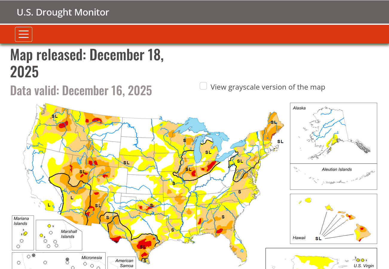
https://www.drought.gov/current-conditions
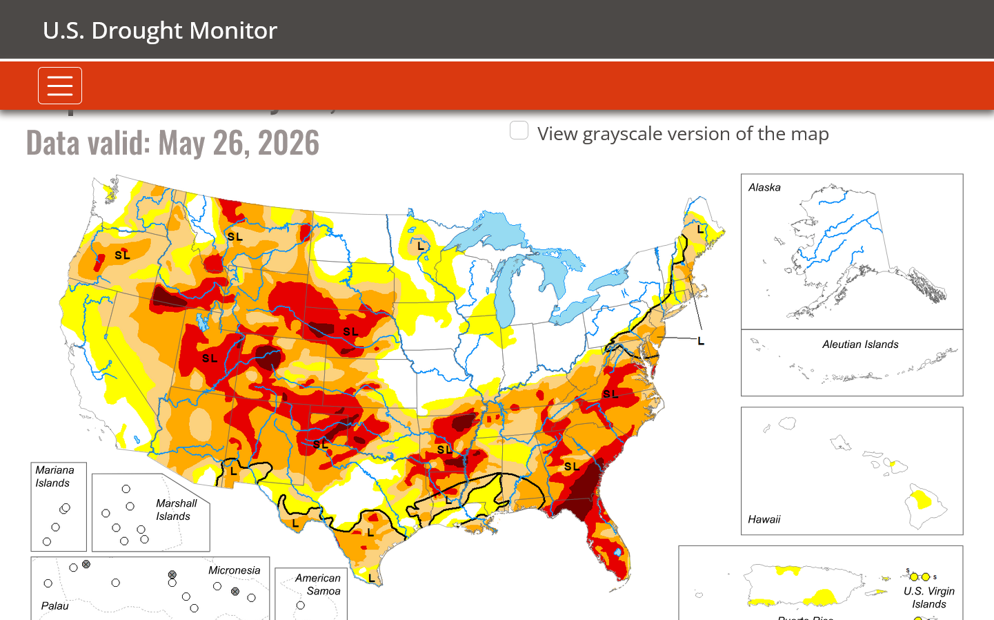
Thru May 16, 2026
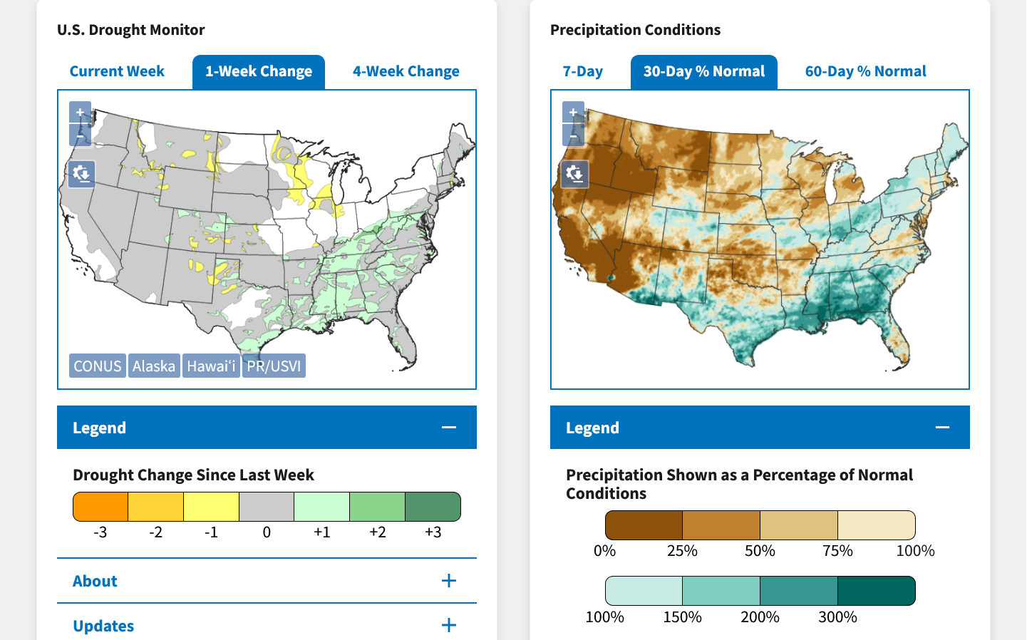
DROUGHT MONITOR
https://droughtmonitor.unl.edu/
Drought improved a great deal in the south!
Flash drought parts of the Midwest!
Drought gone in the Midwest. Much more rain needed elsewhere.
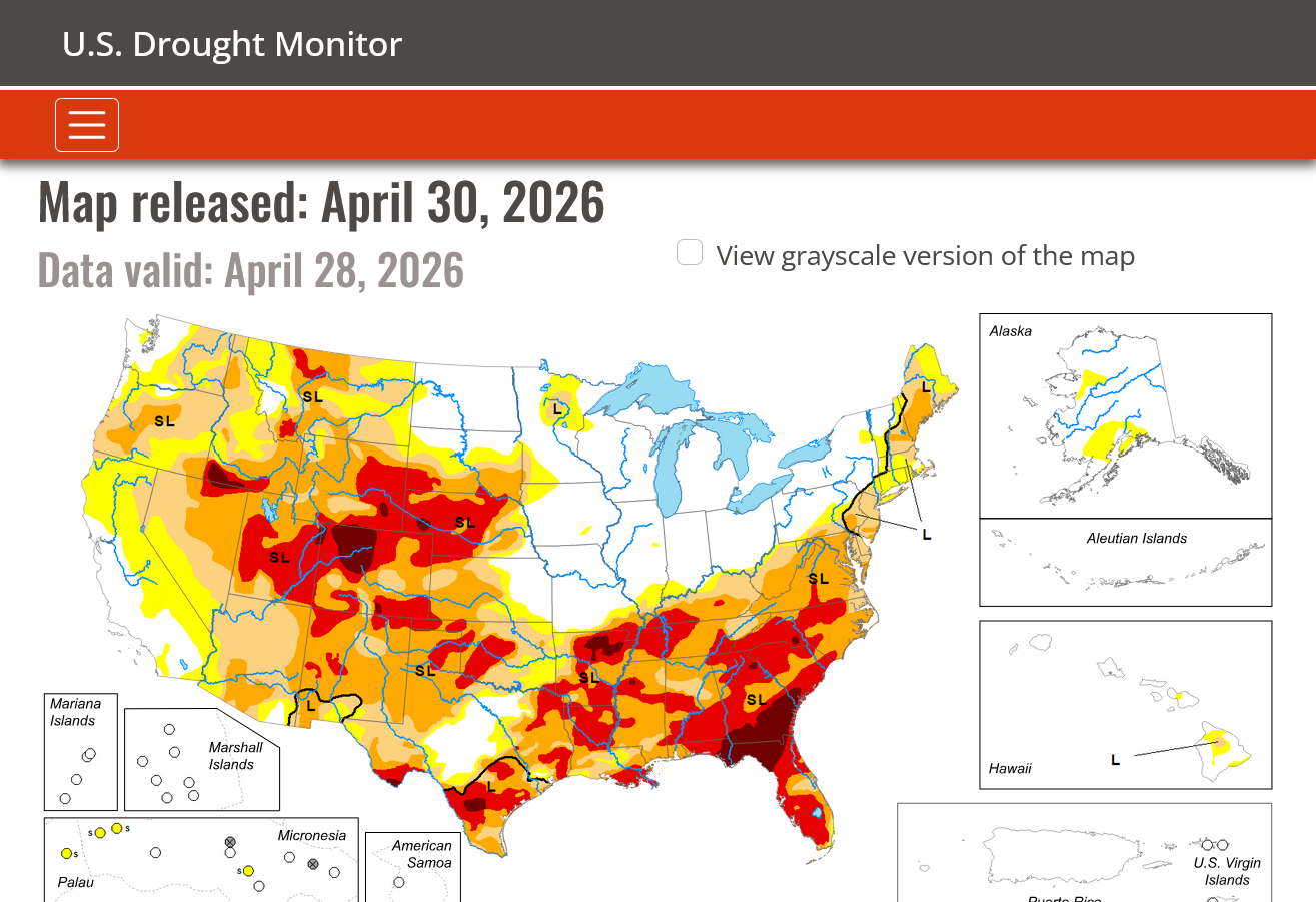
Drought expanding this Winter from Southern Plains, northeastward.
Drought out West has been improving from recent rains:
This is the upper level pattern in 2 weeks for the 3 main models. HOT and mostly DRY in the Plains to Midwest.
BULLISH GRAINS!
5-24-26 updates:
GEFS: 18z
European model: 12z
Canadian model: 12z
Go to this link, put in a/your zip code and find out how much rain fell the past 24 hours.
We're up to .67 inches of wonderful rain here, just north of Evansville, IN. About half of the amount expected but still a bit more tonight.
This is a fun site that shows wind. This has been the windiest year ever based on my memory!
1.6 inches of extremely welcome rains here, just north of Evansville, IN!
Use this link to pinpoint your rain amounts. Just put in your zip code.
https://www.raindrop.farm/rainfall-totals/zipcode/47725#map
+++++++++++
Observed rain amounts: (not sure what time of day this is updated)
https://www.marketforum.com/forum/topic/120018/#120098
Updated ALL except the long range GEFS which comes out late evening.
https://www.marketforum.com/forum/topic/120018/#120019
Updated all the maps. More bullish(less bearish) than last weeks forecasts for the grains.
https://www.marketforum.com/forum/topic/120018/#120019
500 mb maps updated. More bullish compared to last week:
Updated all maps except extended GEFS. Still bullish compared to last week. European Ensemble has rains returning late week 2!
https://www.marketforum.com/forum/topic/120018/#120019
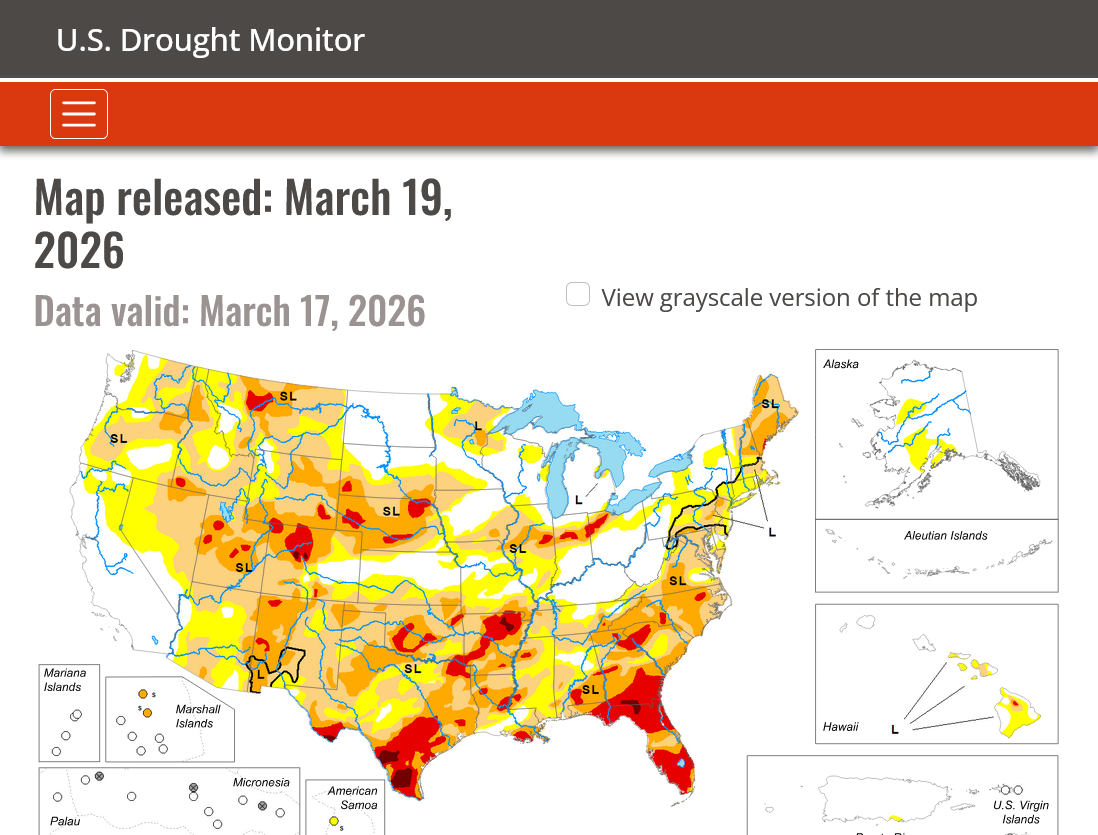
Drought map updated thru 5-28-26
Updated all maps except extended GEFS. LESS bullish compared to yesterday in week 1 and week 2. European Ensemble has the most rain and is more bearish!
Canadian model not shown is also more bearish.
They are basing most of this on the forcing from the rapid onset of El Nino and a strong correlation/analog to favorable growing conditions in the US.
This is consistent with the late 2 evolution of the pattern turning wetter from south to north. The below average temps is totally from expected rain and clouds by the forecasters.
Each year is different. Even an El Nino Summer can have widespread drought!
https://www.cpc.ncep.noaa.gov/products/predictions/WK34/

Updated all maps except extended GEFS. European Ensemble has the most rain and is more bearish for the next 2 weeks!
https://www.marketforum.com/forum/topic/120018/#120019
+++++++++++++++
This is the 16 day total rain forecast from the last 12z Canadian model just for another model opinion.
Our graphics above break down weeks 1 and weeks 2 and give anomalies from the GEFS and European model.
Updated all maps except extended GEFS. GEFS still drier in week 2, especially WCB and CCB.
New rain/drought map:
Rain/Drought thread June 2026
Started by metmike - June 1, 2026, 7:51 a.m.
https://www.marketforum.com/forum/topic/120593/