90% chance of a tropical depression in the next 7 days(mostly likely the next 2 days)

Some awesome data/graphics displayed at this link!
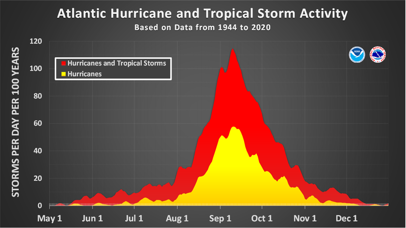
https://www.nhc.noaa.gov/climo/

https://www.ospo.noaa.gov/Products/ocean/sst/contour/

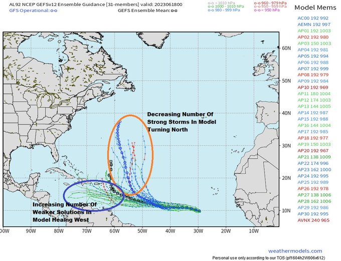
Interesting trend in models Sun AM, the idea of a strong system turning north in the open Atlantic is losing favor to a weaker system continuing west into the Carib. This more west trend increases odds some folks (land) are going to have to deal with it. The timeline now for… Show more
Thanks, Mike.
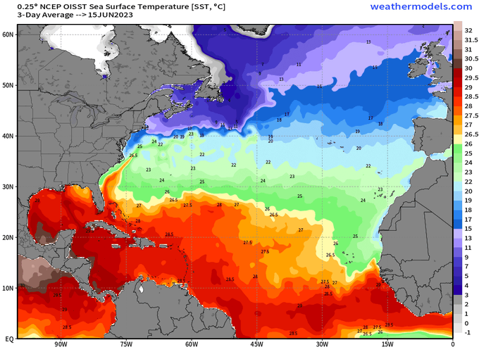
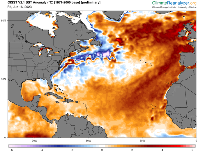
Much of the tropical Atlantic is so warm (warmest on record for June) that it is near the normal for the normally warmest time of year, September! Record low Saharan Dust being pushed out into the Atlantic over the last few weeks has been a significant contributing factor from what I've read.
If this becomes a TS E of the Caribbean, it would become one of the earliest on record.
Larry,
The ocean temperature anomalies right now are insane. If they had gotten like this over numerous years, I would say that it was from global warming and dialed in more warming than had happened previously.
But it has happened in just a couple of months! It's already an extremely long process for the atmosphere to warm up the water.
Water has 4.2 times the heat capacity of air and there being 1,000 times more mass in the oceans..........so 4,000 times more heat stored in them.
Either all the stored heat from global warming for decades is suddenly coming out of the oceans in some bizarre ocean circulation that defies our understanding or some other even more stunning process is causing this.
The rapidity and extent of this warming is stunning and unprecedented and fascinating. I aim to figure out an reasonable explanation(s).
https://www.marketforum.com/forum/topic/95856/#96398
The Blob in the Northeast Pacific was an extreme positive temp anomaly for a long time on a smaller scale
·
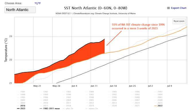
55% of North Atlantic Sea Surface Temperature climate change since 1996 occurred in a mere 3 weeks of 2023. There is only one single possible source for that much heat, in that short a timeframe. This is global. It is NOT 'El Niño'.
·
Parts of the North Sea are >6°C warmer than usual for this time of the year. It's probably the most anomalously warm body of water on the planet. There are severe storm warnings in place for much of Western Europe... [1/2]
+++++++++++++++++
metmike:
This is freaky and the vast majority CAN'T be caused by climate change(I don't think).
This can’t be repeated enough and applies to your wonderful authentic science:
It really boils down to this (Cliff Mass can be counted on as an elite source for using objective, authentic science)
https://cliffmass.blogspot.com/2016/03/the-golden-rule-of-climate-extremes.html
The GoldenRule
Considering the substantial confusion in the media about this critical issue, let me provide the GOLDENRULE OF CLIMATE EXTREMES.
Here it is:
The more extreme a climate or weather record is, the greater the contribution of natural variability.
Or to put it a different way, the larger or more unusual an extreme, the higher proportion of the extreme is due to natural variability.
+++++++++++
So what's causing it? More to come!!!
The aforementioned tropical disturbance (Invest 92L) is now at 100% chance of an upgrade to TD status. Also, Invest 93L in the E Atlantic is getting better organized.
Invest 92L was upgraded to a TD at 11AM.
IN MY "GUT" OPINION ~ HAITI, AND/OR CUBA, WILL NEVER BE THE SAME AFTER THIS SEASON. *I DO HOPE I'M WRONG*
Jean,
Considering the changes in ocean temperatures and atmospheric conditions since the contest deadline, I'm thinking your prediction is potentially looking pretty good right now.
Mktfrm 2023 Atlantic Hurricane Season Forecast Contest: deadline *6/4/23*
30 responses |
Started by WxFollower - May 31, 2023, 4:07 p.m.
https://www.marketforum.com/forum/topic/95746/
However, as Larry noted, late June in previous years with similar El Nino conditions have also been active. But THIS is different with the sudden incredible warmth spike in the Atlantic continuing. I'm still trying to wrap my brain around it.
El Niño tropics: more June activity than non-El Nino Gulf/Caribbean
20 responses |
Started by WxFollower
It appears that Bret is going to be declared with the 5PM EDT NHC advisory per this:
AL, 03, 2023061918, , BEST, 0, 112N, 414W, 35, 1008, TS
This would tie it with Bret of 2017 as the earliest TS in the MDR east of the Caribbean on record back to 1851.
Thanks for the heads up, Larry. Looks like a crazy start to the 2023 hurricane season!
Above-Average Activity Expected In Latest TWC 2023 Atlantic Hurricane Season Outlook
The new outlook from The Weather Company and Atmospheric G2 is for 17 named storms, nine hurricanes and four hurricanes reaching at least Category 3 status. This is an increase of one named storm, one hurricane and one major hurricane since their previous outlook, which was released in mid-May. This increase in named storms and the overall outlook of 17 named storms includes an unnamed subtropical storm that formed in January, but was not added to the official records until May.
Tropical Storm Bret Forms In Eastern Atlantic
"Of the June storms that do form, the overwhelming majority form in the Gulf of Mexico or just off the East Coast.
Only three of 79 June storms since the 19th century have formed east of the Lesser Antilles, according to NOAA's database.
Furthermore, there is no record of two storms active at once in June east of the Antilles. So, if we have both Tropical Storm Bret and Tropical Storm Cindy, that would be unprecedented for that part of the Atlantic Basin in June."
Bret predicted to be a minimal hurricane for several days!
https://www.nhc.noaa.gov/graphics_at3.shtml?start#contents
https://www.nhc.noaa.gov/text/refresh/MIATCDAT3+shtml/192043.shtml?
![[Key Messages]](https://www.nhc.noaa.gov/storm_graphics/AT03/refresh/AL032023_key_messages+png/204424_key_messages_sm.png)
https://weather.com/news/news/five-june-hurricanes-tropical-storms-20120606
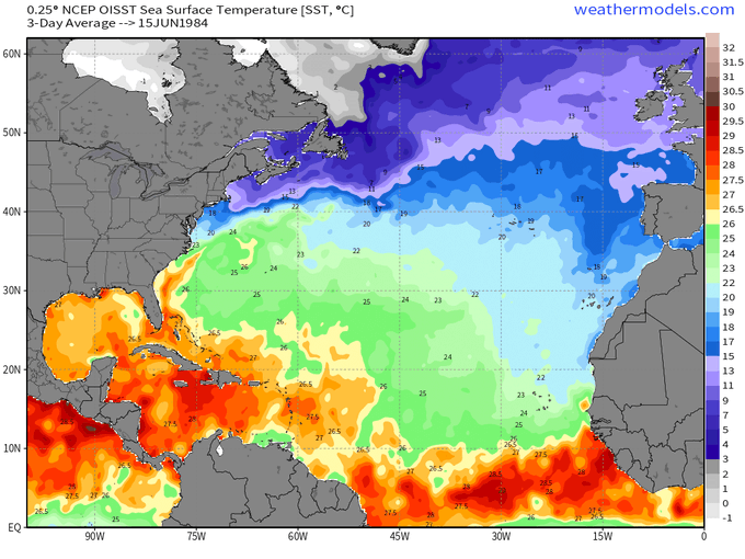
Look at this one! I wonder what the water temps were back then (during global cooling)
The only Category 4 June hurricane on record in the Atlantic Basin, Audrey roared ashore along the Texas and Louisiana border, claiming at least 416 lives in the U.S., the 7th deadliest U.S. tropical cyclone on record. Only Hurricane Katrina (2005) claimed more lives since Audrey.
PLEASE correct me if wrong----------if further west and south of Cuba, the more likely 'moderate' storm, BUT may lead to northerly flow of 'humidity' into cornbelt???
Tjc,
pthe steering currents/flow pattern wont steer it north, no matter what track it takes.unless we get rid of the trough in the east and replace is with ridging.
IS THAT THE START OF A TRAIN. DOWN THERE, OFF AFICA?
TD #4 has been upgraded to TS Cindy.
Thanks, Larry!
1. Hey Mike,
You're welcome.
2. Jean posted: "Furthermore, there is no record of two storms active at once in June east of the Antilles. So, if we have both Tropical Storm Bret and Tropical Storm Cindy, that would be unprecedented for that part of the Atlantic Basin in June."
Well, we got the two storms!
3. Bret became a TS at 42.2W, which is the furthest east of any ON RECORD in June back to 1851.
Pretty amazing but with the very warm Atlantic, not surprising.
Learning new things every week. This week, I'm amazed to learn about a ferocious JUNE hurricane. This one below, in 1957 (during global cooling) also had one of the greatest impacts on Canada of any tropical system in history.
https://en.wikipedia.org/wiki/Hurricane_Audrey
Hurricane Audrey was one of the deadliesttropical cyclones in U.S. history, killing at least 416 people in its devastation of the southwestern Louisiana coast in 1957. Along with Hurricane Alex in 2010, it was also the strongest June hurricane ever recorded in the Atlantic basin as measured by pressure.
Larry remembers this situation.........until fracking replaced most of this production:
Prior to making landfall, Audrey severely disrupted offshore drilling operations in the Gulf of Mexico. Damages from offshore oil facilities alone was estimated at $16 million.[nb 2] Audrey caused much of its destruction near the border between Texas and Louisiana
++++++++++++
The formation and development of Hurricane Audrey was multi-faceted. One contributor to Audrey's formation—an area of anomalously low pressures roughly 10,000 ft (3,000 m) above sea level—was first detected in the western Caribbean Sea on June 11. In an analysis of weather patterns from June 1957, Weather Bureau meteorologist William H. Klein noted the potential for research on similar disturbances to shed light on tropical cyclone development.[2] Concurrently, surface observations suggested the progression of a disorganized tropical wave tracking westward across the Caribbean Sea beginning on June 20,[3] eventually entering the Bay of Campeche on June 22.[4] At 12:00 UTC on June 24 (7:00 a.m. CST), storms associated with the wave organized into a tropical depression based on ship reports in the bay;[4] at the time, the first indication of a developing tropical cyclone originated from a report from a shrimp boat.[5] The depression was in a highly favorable environment for intensification in the western Gulf of Mexico; sea surface temperatures in the area were at 85 °F (29 °C), or 3 °F (2 °C) above normal for the time of year. In addition, the latitudinal alignment of a polar trough over the Great Plains and the nascent disturbance in the Bay of Campeche created an environment suitable for outflow in the upper-levels of the atmosphere.[2] Taking advantage of these conditions, Audrey reached tropical storm strength just six hours after being classified as a tropical depression while remaining nearly stationary.[6]
https://rogerpielkejr.substack.com/p/just-the-facts-on-global-hurricanes


![[Key Messages]](https://www.nhc.noaa.gov/storm_graphics/AT03/refresh/AL032023_key_messages+png/144622_key_messages_sm.png)