Warm enough thru, especially the southern half of IA because of the weekend heat BUT the weather forecast is the problem. See maps and forecast below. This map is updated daily.
https://mesonet.agron.iastate.edu/agclimate/soilt.php

Purple is a freeze warning. Blue is frost advisory. This won't be the best thing for newly planted corn. If there was newly emerged corn, with the growing point still protected below the surface it wouldn't be killed.......but there wasn't any corn planted a week ago, so there shouldn't be much emerged corn.
The problem is the huge drop in soil temperatures we will see, which will make it unfavorable to plant corn for awhile.
Producers in IA, N.IL knew this was coming and are waiting for sustained warmth.
We'd like to be 50+ and STAY above that. Planting in cold ground leaves the seeds vulnerable and plants that emerge, then sit in cold ground get off to a bad start.
Current Hazards map from the Severe Storm Forecast Center
Freeze warning in purple will feature temps not cold enough to hurt wheat this early in the chilly so far, Spring.
Hit the hazards button at the link below.
https://www.canr.msu.edu/news/is_it_warm_enough_to_plant_corn
Soil and water temperatures below 50 degrees Fahrenheit can damage corn seed and reduce yield.
To determine the risk of chilling injury, check the soil temperature in the field.
If soils are less than 50 F or are expected to fall during the 48 hours after planting, wait to plant.

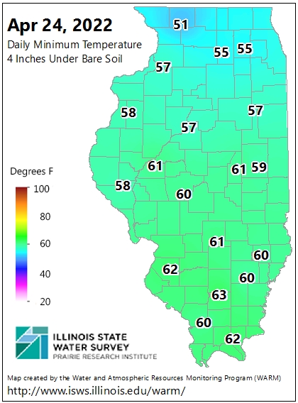
metmike: Soil temperatures on the internet are pretty accurate and producers are excellent at tracking the forecast and expected impacts on their soils/crops.
Full report here:
Latest weather:
NEW: La Nina/-PDO with latest Summer Forecast 4-25-22
13 responses |
Started by metmike - April 26, 2022, 6:59 p.m.
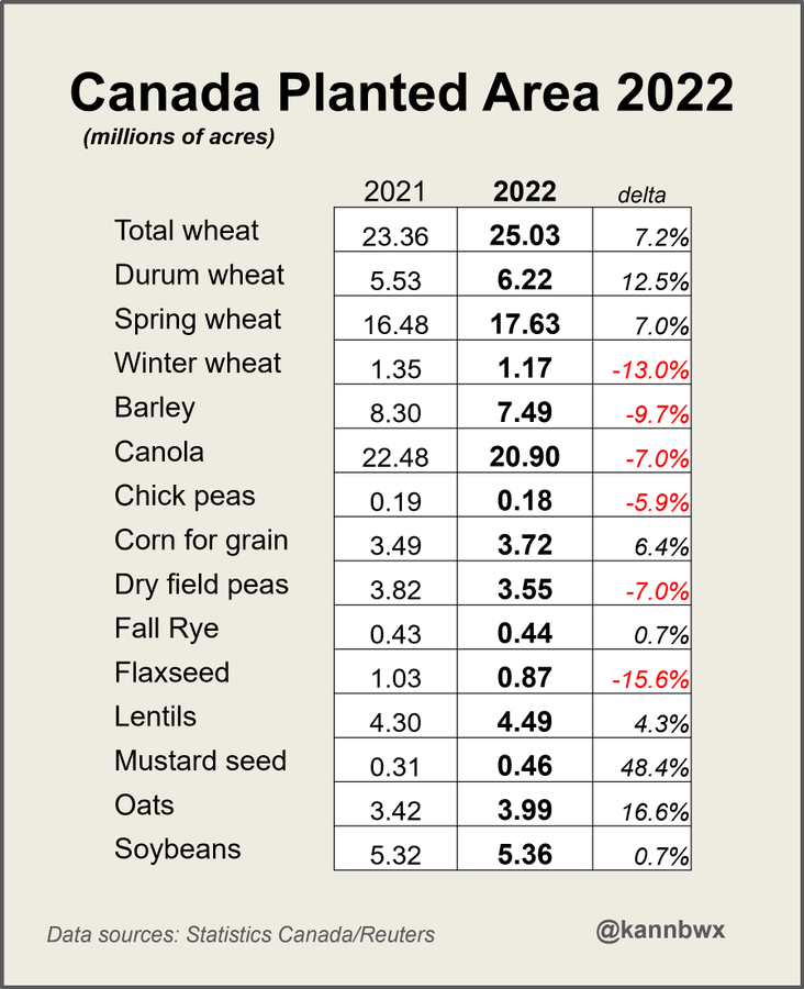
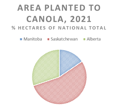
Saskatchewan is by far Canada's biggest canola producer. This chart comes from USDA's GAIN report from earlier this month. Farmers planted a very strong canola area in 2021, but production was the worst since 2007 and down 35% from 2020 because of the drought.
Rain amounts for next week have jumped way up. Bad for planting prospects. Bullish for corn prices, bearish for HRW prices(some drought areas get rain).
The latest precip forecasts are below.
Day 1 below:
http://www.wpc.ncep.noaa.gov/qpf/fill_94qwbg.gif?1526306199054

Day 2 below:
http://www.wpc.ncep.noaa.gov/qpf/fill_98qwbg.gif?1528293750112

Day 3 below:
http://www.wpc.ncep.noaa.gov/qpf/fill_99qwbg.gif?1528293842764

Days 4-5 below:
http://www.wpc.ncep.noaa.gov/qpf/95ep48iwbg_fill.gif?1526306162

Days 6-7 below:
http://www.wpc.ncep.noaa.gov/qpf/97ep48iwbg_fill.gif?1526306162

7 Day Total precipitation below:
http://www.wpc.ncep.noaa.govcdx /qpf/p168i.gif?1530796126

Excessive rain threat.
https://www.wpc.ncep.noaa.gov/qpf/excess_rain.shtml
Current Day 1 Forecast
Day 1 Threat Area in Text Format
Current Day 2 Forecast |

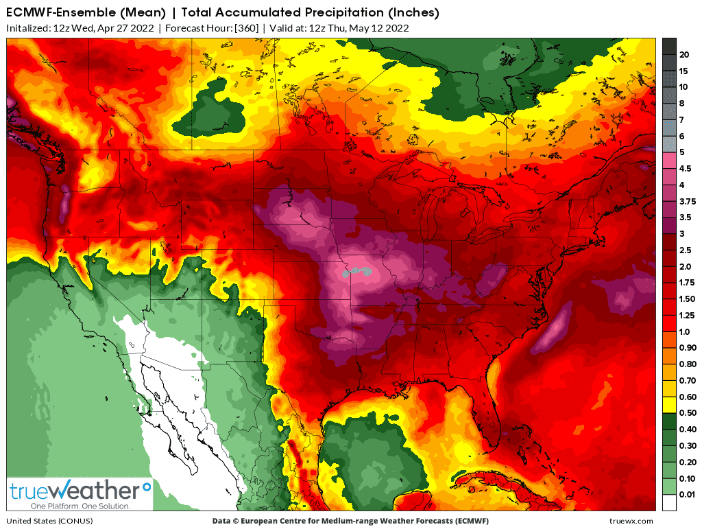
2 week rain totals from the last 0Z European model:
Last 12z European model update for 2 week rains. The grey in the epicenter is 5 inches of rain. The far western part of the rain shield is in the eastern and northern drought areas where the HRW crop is stressed. It will help.
The majority is very UNwanted to producers that really want to get started planting.
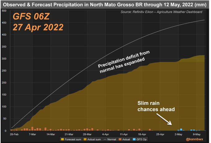
No more rain is forecast in April so the first chart should fully reflect the month. Forecast shows dry trend likely to continue into early May. Need to be careful w/ departure from normal in Mato Grosso because normal can be A LOT! But clear by first chart this is indeed dry.
First decent rain in a very long time for some of the dry HRW areas is clobbering wheat, especially HRW prices right now.
Sunday Night/Monday is the ideal time frame.
Could have a gap lower on Sunday NIght's wheat:
Wheat did in fact gap lower on the open tonight.
However, the HRW belt has LESS rain from this current system than it did in Friday's forecast, so its LESS bearish compared to the SRW so far this evening.
HRW, filled it's gap barely and actually got into positive territory shortly after the open(but Fri saw -35c and it didn't recover any of that) before making new lows below $11, then bouncing back above that at the moment.
SRW gapped lower and has NOT filled the gap but its early still, been trading just 34 minutes.
SRW is -8c
HRW is -3c to -4c
This basically reversed the spread from Friday which saw HRW LOSE 5c vs SRW because of the rain.
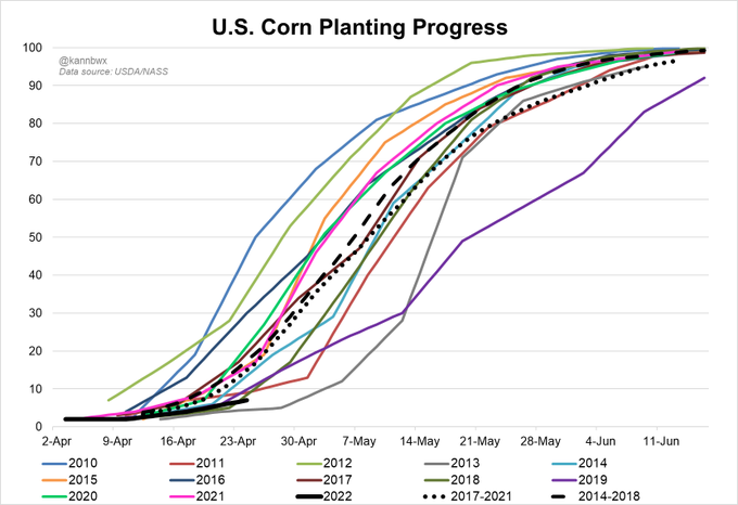
C and S have been lower, probably from warmer weather in the Upper Midwest and better planting, starting at the end of this week.
See the latest comprehensive weather here:
SRW -15c, HRW -6c, so SRW losing even more vs HRW than it gained on HRW on Friday with the spread.
C and S -9c.
SRW -18c, leaving the gap lower wide open........looking like a downside breakaway gap!
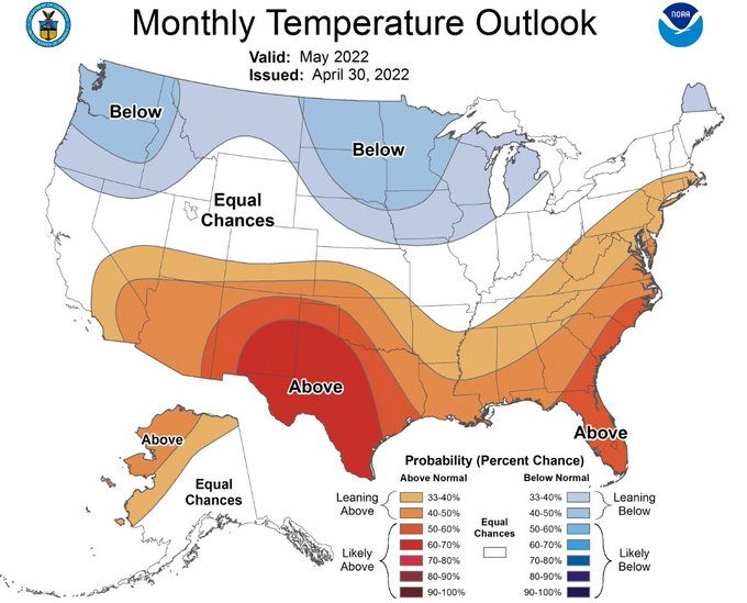
metmike: Take this forecast with a grain of salt:
CPC predicts that U.S. #Corn Belt temperatures in May are likely to be normal/cooler than normal, and precipitation could be heavier than normal in the western and northern areas. Generally, cool & wet is not the ideal combo for planting.
Summer Forecast here:
NEW: La Nina/-PDO with latest Summer Forecast 4-26-22
23 responses |
Started by metmike - April 26, 2022, 6:59 p.m.
https://www.marketforum.com/forum/topic/83698/
+++++++++++++++++++++++++++++++++++
https://www.marketforum.com/forum/topic/83698/#83709
https://www.cpc.ncep.noaa.gov/products/predictions/long_range/
https://www.cpc.ncep.noaa.gov/products/predictions/long_range/seasonal.php?lead=2


SRW also filled the gap lower this morning, similar to HRW after the open last night.
Rains with this event, as mentioned last night would be LESS than predicted on Friday but we have another BIGGER event coming up midweek.
However, maybe the biggest news is, as mentioned yesterday is the potential warm up coming in week 2 with a potential major weather pattern change that will allow for corn and bean planting to catch up later this month.
It will also bring HOT/dry weather to the C/S Plains.
So bearish C and S and bullish wheat prices AFTER this next rain event.


