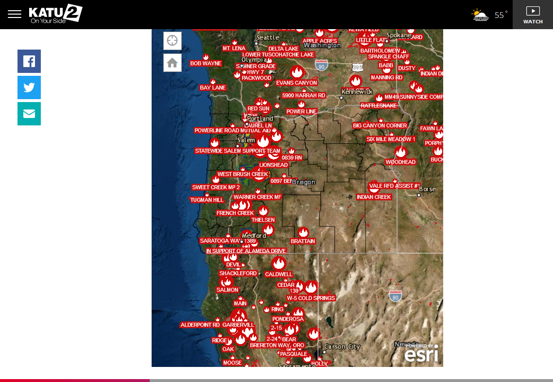
You probably have read or seen stories on the huge fires raging out West.
I have a brother, Brian that lives in Portland OR with his wife, Lisa that are dealing with the dense smoke.
Let's open up a thread here covering these fires.
What caused these fires?
The stage was set from very dry weather recently.
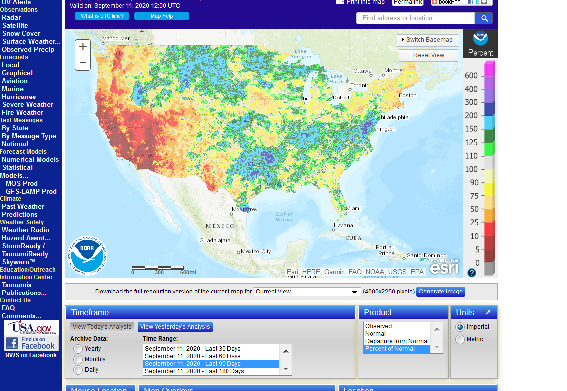
The map below shows 90 day precip % average. Note that much of the country has been wet but the Central/Southern Rockies to the West Coast have been extremely dry:
https://water.weather.gov/ahps/
++++++++++++++++++++++++++++++++++++++++++++++++
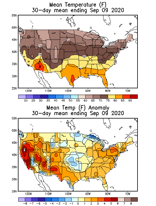
https://www.cpc.ncep.noaa.gov/products/tanal/temp_analyses.php
Temperatures have also been well above average the last 30 days:
What caused it to be hot/dry?
The natural La Nina(not climate change) was likely the main factored!
But NOAA just declared a La Nina earlier this week you might say.
Yes, but it took 3+ months for Eastern Tropical Pacific Ocean water temps to continue to cool and stay down there to meet the official La Nina requirements, while the atmosphere was not waiting around for NOAA to tell it "We've crossed the human defined oceanic measured threshold for defining La Nina's, you can act La Nina like now"
The atmosphere has been in La Nina mode for 3 months which creates a strong tendency for dryness and droughts in many parts of West.
Also hot weather there to sometimes into the Plains/Midwest and cooler east is sometimes seen.
La Niña has formed
6 responses |
Started by metmike - Sept. 11, 2020, 11:32 a.m.
https://www.marketforum.com/forum/topic/59007/
My Summer Forecast/La Nina this Summer!
39 responses |
Started by metmike - May 23, 2020, 11:33 p.m.
https://www.marketforum.com/forum/topic/52701/
This has really dried out the soils and vegetation:
https://www.cpc.ncep.noaa.gov/products/Soilmst_Monitoring/US/Soilmst/Soilmst.shtml#
![]()

++++++++++++++++++++++++++++++++++++++++++++++++++
Drought Monitor maps:
September 10: We should probably be noting the real drought out West. The Rockies back to OR is the most severe.
https://droughtmonitor.unl.edu/

In addition, in recent years, an increase in beneficial CO2 has resulted in a massive increase in vegetative growth around the planet for all plants, including trees, lower brush, crops.......etc. Climate change has also contributed positively.
https://www.nasa.gov/feature/goddard/2016/carbon-dioxide-fertilization-greening-earth
From a quarter to half of Earth’s vegetated lands has shown significant greening over the last 35 years largely due to rising levels of atmospheric carbon dioxide, according to a new study published in the journal Nature Climate Change on April 25.
An international team of 32 authors from 24 institutions in eight countries led the effort, which involved using satellite data from NASA’s Moderate Resolution Imaging Spectrometer and the National Oceanic and Atmospheric Administration’s Advanced Very High Resolution Radiometer instruments to help determine the leaf area index, or amount of leaf cover, over the planet’s vegetated regions. The greening represents an increase in leaves on plants and trees equivalent in area to two times the continental United States.

This image shows the change in leaf area across the globe from 1982-2015.
Credits: Boston University/R. Myneni
Green leaves use energy from sunlight through photosynthesis to chemically combine carbon dioxide drawn in from the air with water and nutrients tapped from the ground to produce sugars, which are the main source of food, fiber and fuel for life on Earth. Studies have shown that increased concentrations of carbon dioxide increase photosynthesis, spurring plant growth.
However, carbon dioxide fertilization isn’t the only cause of increased plant growth—nitrogen, land cover change and climate change by way of global temperature, precipitation and sunlight changes all contribute to the greening effect.
This would all be wonderful but when it turns hot/dry from natural weather, like we have seen out West this Summer, green things dry out and turn brown/dead. All that extra green vegetation that dried out has increased the fuel load in areas that are not applying aggressive/effective forest management(in some cases).
Regardless of how effective management is for some locations, there is around 25% more vegetative growth around the planet because of the increase in CO2, going from less than 300 parts per million a century ago to 418 ppm currently... that is well mixed in the global atmosphere. This is considered almost entirely beneficial in all realms................but not for wildfires because it turns into fuel.
This is the recipe for massive wildfires.
If such a choice was actually possible, one could actually ask:
Do we want to feed an extra billion people because of massive crop increases with atmospheric fertilization of all crops at 418 ppm of CO2 and have more severe wildfires orrrr do we want to reduce the intensity of wildfires a bit by taking CO2 back to where it was and have 1 billion people starve to death within 3 years?
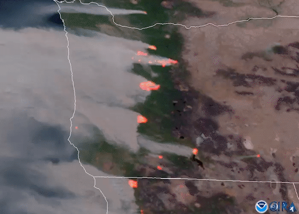
Earlier this week, we had a very unusual weather pattern with a strong cold front dropping temperatures cold enough for snow in the Rockies but it also featured very strong east winds in Oregon(known as "Santa Ana" winds farther south), so that the raging fires were blowing thick smoke from east to west, all the way to the coast, well out into the Pacific Ocean covering many cities, including Portland.
Sept. 10, 2020

In Southern California the Santa Ana winds are kicking up causing more problems for crews trying to contain the flames; Jeff Paul reports on the latest.
The wildfires ravaging California and Oregon have been spotted from space in remarkable satellite pictures.
Winds have shifted so that they are no longer coming from the east and blowing more concentrated smoke in, but the smoke plumes are well entrenches for hundreds of miles surrounding these areas. It will take a couple of days to dilute/settle out the smoke and then finally bring in more marine type air by later in the weekend, followed by wonderful rains early next week that should cleanse the air and help put out the fires.
You won't see a forecast like this one below too often.
Extended Forecast for


Help could be on the way next week Brian!!
Liquid equivalent precip forecasts for the next 7 days are below.
Day 1 below
http://www.wpc.ncep.noaa.gov/qpf/fill_94qwbg.gif?1526306199054
Day 2 below:
http://www.wpc.ncep.noaa.gov/qpf/fill_98qwbg.gif?1528293750112
Day 3 below
http://www.wpc.ncep.noaa.gov/qpf/fill_99qwbg.gif?1528293842764
Days 4-5 below:
http://www.wpc.ncep.noaa.gov/qpf/95ep48iwbg_fill.gif?1526306162
Days 6-7 below:
http://www.wpc.ncep.noaa.gov/qpf/97ep48iwbg_fill.gif?1526306162
7 Day Total precipitation below:
https://www.wpc.ncep.noaa.gov/qpf/p168i.gif?1566925971
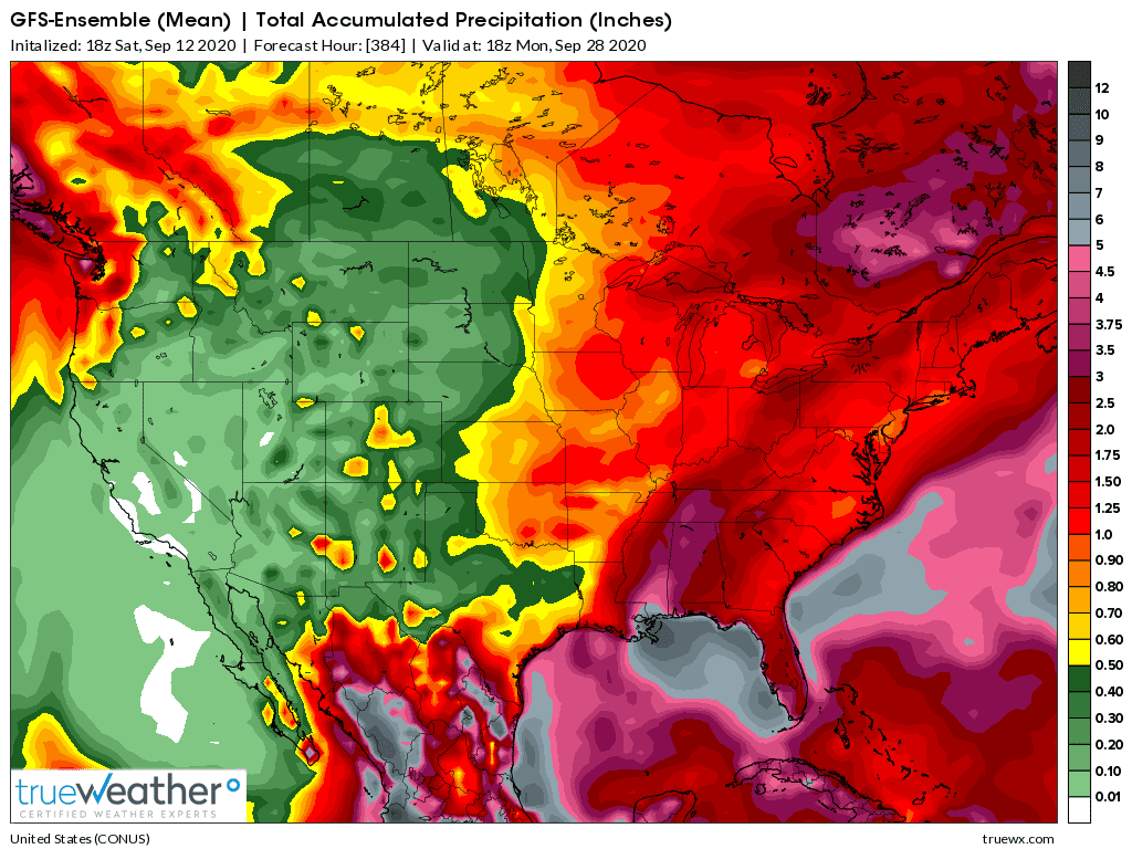
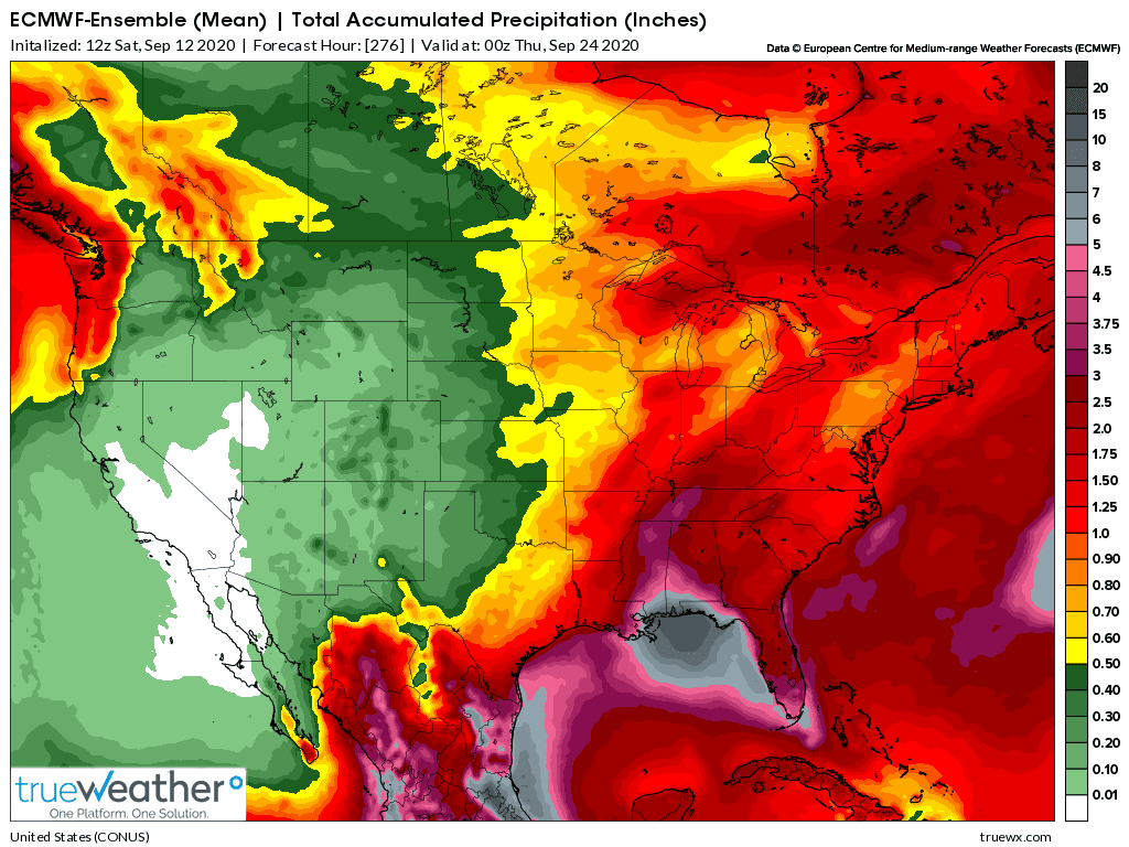
The GFS/American model continues to be less bullish on rainfall amounts(1st map) as the European model(2nd map)
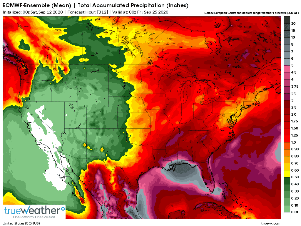
GFS first, then Euro model.
They are in closer agreement than yesterday but the GFS has increased rains more...........and the Euro is around the same to slightly more.
This would lead one to believe, based on the trend that the Euro is doing a better job.
These are rain totals for the next 15 days but all of it will fall in the next 8 days, then it turns completely dry again.
For Portland:
Visibilities the last day.
Smoke was the main condition and it was reducing the visibility to 1.50 most of the time the previous day, but as low as .75 for a short while late Friday afternoon.
Then, suddenly, the visibility plunged from 1.5 to .25 at 4:53 am. This is when dense fog took over as the main condition. The smoke was still there but the dense fog was reducing visibility even more/the most so it got top billing for several hours until mid morning at which time the fog started lifting and visiblity increased just a bit, then haze/mist got listed as the main condition but there still must have been close to the same amount of smoke as before, but for whatever reason, based on their criteria was not #1............until a couple of hours ago, when smoke returned to top billing.
Thru the entire period, the amount of smoke has probably been close to the same(massive) but other elements bumped it out of top billing using their criteria. Clearly(no pun intended) when the visibility was just .25, early this morning there must have been some pretty dense fog.
It's only .50 right now, lower than it was all day Friday and there's no reason for the smoke to be thicker so there are other elements in addition to the smoke reducing visibility(haze).
Very early on Sunday will likely feature more dense fog, smoke, haze and mist all colluding(just kidding) to keep the visibility extremely low.
With the strong smell of smoke in the air and plenty of it, its probably hard to tell how much of each is there(fog and haze would not give a smell).
When the visibility was .25 or even near zero in some places earlier this morning, maybe it seemed like mostly smoke.
With dense fog, its usually very patchy and concentrated in low spots. Maybe at one location it was never dense and other locations the visibility was near 0.
Seems like a lot of time to spend on something that would appear to be trivial to most people reading this but I'm sure its anything but trivial to people living out there right now.....or to a meteorologist!
https://www.wrh.noaa.gov/mesowest/getobext.php?wfo=pqr&sid=KPDX&num=72&raw=0
I'll add the latest rain forecasts in the next email again. First the GFS, then the European model.
| ||||||||||||||||||||||||||||||||||||||||||||||||||||||||||||||||||||||||||||||||||||||||||||||||||||||||||||||||||||||||||||||||||||||||||||||||||||||||||||||||||||||||||||||||||||||||||||||||||||||||||||||||||||||||||||||||||||||||||||||||||||||||||||||||||||||||||||||||||||||||||||||||||||||||||||||||||||||||||||||||||||||||||||||||||||||||||||||||||||||||||||||||||||||||||||||||||||||||||||||||||||||||||||||||||||||||||||||||||||||||||||||||||||||||||||||||||||||||||||||||||||||||||||||||||||||||||||||||||||||||||||||||||||||||||||||||||||||||||||||||||||||||||||||||||||||||||||||||||||||||||||||||||||||||||||||||||||||||||||||||||||||||||||||||||||||||||||||||||||||||||||||||||||||||||||||||||||||||||||||||||||||||||||||||||||||||||||||||||||||||||||||||||||||||||||||||||||||||||||||||||||||||||||||||||||||||||||||||||||||||||
I Believe arson has also been a big factor.
You are correct Tim
So far that I am aware of
4 arrests have been made for arson connected to the fires
One wonders how many fires have been set and not known
It takes a sick fire bug to set a fire and then endanger lives, both animal and human
California governor blames wildfires on climate 'emergency'
My concern yesterday that the rains may not come very far inland initially is more than just that right now.
The main weather system is going to stay off the coast until later this week. A cold front ahead of it that was supposed to generate rains today has
weakened and is greatly UNDER performing.
It will fizzle out and the chance of rains will not be great until the main system finally tracks closer.
The chance of rain really picks up on Thursday Morning. The delay in the rains doesn't mean that this weather system and its rains are not still on the way. Just that the first round, that was expected to be lighter, is going to be even less.
Not that this adjustment is made, just watch big rains develop sooner than expected

Go to: Most Recent Image
How much the rain will help clear the smoke depends on how much there is and how the fires react to it.
++++++++++++++++++++++++++++++++++++++++++
metmike: Of course the rain is going to clean the air, starting as soon as it starts falling and continuing, despite what they say.
Thru wet deposition, the particulate matter will coagulate around the rain drops and be washed out of the air..................this is what rain does.
As far as more smoke initially from dousing the flames. OK, that might be true immediately downwind from the wildfires (and the winds will be light, unlike the ones that caused it early last week) on a limited scale but offset by the rain washing it out.
Here are some interesting articles on this topic.
https://news.mit.edu/2015/rain-drops-attract-aerosols-clean-air-0828
++++++++++++++++++++++++++++++++++++++++++++++++++++
https://blog.breezometer.com/air-pollution-weather-rainy-day
| Air Pollution on a Rainy Day: Understanding Weather & Air Quality Weather has a significant impact on air quality and pollution, with rain and wind often lowering pollution levels, while summer-time heat can make things a lot worse. blog.breezometer.com |
But here is the most interesting thing about this.
More pollution/smoke causes more water droplets to form in clouds (because of the greater # of condensation nuclei but SMALLER drops than clean air. This probably increased your fog too.
It's the bigger drops that fall to the ground because of gravity. The smaller ones can stay suspended in the clouds and not fall to the ground.
As a result, pollution decreases rainfall, with the greater number of smaller drops staying in the clouds.
One could speculate that all this smoke has suppressed the production of the bigger drops and is a factor in this early week rain event fizzling..
https://phys.org/news/2019-12-pollution.html
 | More pollution, less rain - Phys.org More information: Sat Ghosh et al. A meteorological discourse on extreme storm events driven by Asian slum emissions, International Journal of Environment and Pollution (2019).DOI: 10.1504/IJEP ... phys.org |
https://www.nature.com/news/2007/070305/full/070305-11.html
| Pollution decreases rainfall : Nature News Nature - the world's best science and medicine on your desktop www.nature.com |
https://svs.gsfc.nasa.gov/20010
Normal rainfall droplet creation involves water vapor condensing on particles in clouds. The droplets eventually coalesce together to form drops large enough to fall to Earth. However, as more and more pollution particles (aerosols) enter a rain cloud, the same amount of water becomes spread out. These smaller water droplets float with the air and are prevented from coalescing and growing large enough for a raindrop. Thus, the cloud yields less rainfall over the course of its liftime compared to a clean (non-polluted) cloud of the same size. The split screen compares a normal rain producing cloud (left) with the lack of rain produced from a cloud full of aerosols from pollution.
Cloth masks do no good for smoke/pollution and they let all the COVID virus in and out too.
You need an N-95 mask to filter out the tiny dust, smoke or virus particles.
Luckily, I had a big box, purchased 15 years ago.
Was using one outside while blowing the patio, deck and driveway for the actual reason they were purchased. It used to be strange to put one on before this year. Now its natural.
Health experts said N-95 masks are the only ones that stop smoke particles.
 | Worsening air quality raises questions about which COVID-19 masks work best for smoke | KOMO With the air quality only expected to get worse, a lot of people are wondering if their face covering to protect them from COVID-19 will work for smoke. Everywhere you go now, you’ll likely ... Health experts said N-95 masks are the only ones that stop smoke particles. But they said you should not rush out and buy one. “If you need to be outside for a long period of time, it might be particles worth thinking about a tight-fitting mask like an N-95 but recognize these are in very short supply and we want to reserve those for essential personal,” said Dr. Seth Cohen with UW Medical Center. Save the N-95s for medical staff and essential workers. |
I did a quick check on N-95 masks and it appears that most places are out and they are charging around 25 times more per mask then what I paid 15 years ago for ours.
I paid less than 50c each back in 2005(it might have been closer to .25c) and they are charging $10 per mask at some places!!!!
I got a pack of 40 for, what I remember was just over $10.
Some places want that for 1 mask today!!!!
https://clinicalsuppliesusa.com/collections/n95-mask
| N95 Masks | Buy N95 Face Masks Online from US [In-Stock] – Clinical Supplies USA N95 masks (in stock now) can be effective in filtering out 95% of unhealthy airborne particles, helping you breathe easier. Buy N95 masks online now for fast delivery. clinicalsuppliesusa.com |
https://www.homedepot.com/b/Safety-Equipment-Respirator-Masks/N95/N-5yc1vZc25kZ1z195hh
| N95 - Respirator Masks - Safety Equipment - The Home Depot Get free shipping on qualified N95 Respirator Masks or Buy Online Pick Up in Store today in the Safety Equipment department. www.homedepot.com |
Rains in the Portland area on Friday helped clear the smoke out.

Starting at 3:30pm on Friday, smoke vanished from the weather description(as a main weather element) in Portland and the visibility jumped to 10 miles, which is the highest they give and has stayed there.
The visibility had already increased quite a bit from 24 hours earlier because of the rain but right at that time, winds picked up quite a bit and it looks like a drastic change to no smoke that happened pretty fast.
Hourly Observations going back 3 days below.
This is constantly updated to the most recent 3 days.
https://www.wrh.noaa.gov/mesowest/getobext.php?wfo=pqr&sid=KPDX&num=72&raw=0


