Most of the Eastern half of the country will see temperatures around 20 degrees above average on Christmas Day this year.
This includes our wonderful location, here in Evansville Indiana. The forecast high on Christmas Day should be in the low 60's deg. F.
Update 2-23..........possibly mid 60's
How does this compare to previous Christmas Days?
Here is a comprehensive look at our historical weather for Christmas and also, on this date, which is the 15 year anniversary for the biggest snowstorm ever this area. Thanks to the meteorologists in Paducah, KY for compiling much of the data!
Scroll down for the report.
Christmas Day Climate History for Evansville, IN
*Climate Data has been recorded at Evansville Regional Airport since January of 1897. Snowfall records began in January of 1948.
Here is a look at high and low temperature frequencies and extremes as well as precipitation statistics for Christmas in Evansville.

As seen by this graphic high temperatures are predominately in the 30s and 40s on Christmas, encompassing 70% of all years on record.
| Warmest Highs | Coldest Highs |
| 68 in 1982 | 10 in 1983 |
| 63 in 1932 | 14 in 1985 |
| 61 in 2016 | 14 in 1924 |
| 61 in 1922 | 21 in 1902 |
| 58 in 2015 | 22 in 2000 |
| 58 in 1973* | |
| Normal High: | 42 |
*Denotes a tie in previous year(s)
Evansville has seen highs as warm as the 60s 4 times on Christmas, most recently in 2016. There have also been 3 years where the high temperature failed to reach 20 degrees, most recently in 1985.
Here in 2019, should we hit 60 degrees on Christmas in Evansville, it would be our 5th warmest Christmas. Hitting 62 would make it the 3rd warmest(this looks doable), 64 would be our 2nd warmest. We need to get all the way up to 69 deg. F in order for this to be the warmest Christmas in our NWS history, dating back 122 years.
12-23........Let's go for 66 and make it the 2nd warmest!

Low temperatures typically fall in the 20s or 30s, which accounts for 68% of the years on record. There have been 2 years with lows below 0, most recently in 2004 when it tanked to 11 below zero. On the warm end of the spectrum, there have been 11 years with lows above 40 degrees. This last occurred in 2016.
| Warmest Lows | Coldest Lows |
| 51 in 1982 | -11 in 2004 |
| 48 in 2015 | -7 in 1983 |
| 43 in 1940 | 0 in 2000 |
| 43 in 1936 | 3 in 1985 |
| 42 in 1942 | 3 in 1924 |
| 42 in 1904 | |
| Normal Low: | 25 |
Our forecast low on Christmas morning is around 40 degrees. If the temperature managed to stay at or above 44 on Christmas morning, it would be our 3rd warmest low temperature for this date going back 122 years!
Measurable precipitation has fallen 37% of the time, with over an inch of precipitation falling on 3 different occasions, most recently in 2006. Measurable snowfall has only occurred on 7 occasions (10% of all years on record), with the greatest being 2.3 inches in 1993. There have been 9 years (13% of all years on record) classified as a white Christmas with a snow depth of 1 inch or greater. This last happened in 2010 when there was 1 inch of snow on the ground Christmas morning. The largest snow depth observed on Christmas morning was back in 2004 when there was an astounding 11 inches!
| Wettest (inches) | Snowiest (inches) | Most Snow Depth |
| 1.96 in 1987 | 2.3 in 1993 | 11.0 in 2004 |
| 1.79 in 1982 | 2.1 in 1969 | 6.0 in 1963 |
| 1.03 in 2006 | 0.7 in 1992 | 4.0 in 1969 |
| 0.88 in 1975 | 0.7 in 1975 | 2.0 in 2000 |
| 0.85 in 1944 | 0.1 in 2002* | 2.0 in 1990* |
*Denotes a tie in previous year(s)
You will note the most snow depth was in 2004.............by a wide margin. This is what was still left from the all time record snow storm that occurred several days previous to Christmas 2004. More on that below.
We will have clear skies on Christmas this year..................no chance for rain or snow.
Here is a look at the observed weather for the past 15 years:
| Recent Christmas Day Weather | |||||
| Year | High | Low | Precip | Snowfall | Snow Depth |
| 2004 | 25 | -11 | 0 | 0 | 11 |
| 2005 | 45 | 34 | 0.22 | 0 | 0 |
| 2006 | 41 | 38 | 1.03 | 0 | 0 |
| 2007 | 50 | 25 | 0 | 0 | 0 |
| 2008 | 36 | 20 | 0 | 0 | 0 |
| 2009 | 54 | 31 | 0.2 | T | 0 |
| 2010 | 33 | 29 | T | T | 1 |
| 2011 | 55 | 28 | 0 | 0 | 0 |
| 2012 | 37 | 30 | 0.01 | 0 | 0 |
| 2013 | 38 | 21 | 0 | 0 | 0 |
| 2014 | 49 | 38 | 0 | 0 | 0 |
| 2015 | 58 | 48 | T | 0 | 0 |
| 2016 | 61 | 41 | 0.04 | 0 | 0 |
| 2017 | 31 | 20 | T | T | T |
| 2018 | 50 | 32 | 0 | 0 | 0 |
Below, you will note the 19.3 inches of snow that fell on December 22, 2004. .......the most ever for any day in our NWS history and most of the 22.3 inch total from that storm. In fact, today is the 15 year anniversary of that snowstorm............glad I was 15 years younger back then to shovel all that snow!!!
There was still plenty left for Christmas that year but most of it had melted before the end of the year from a huge warm spell. .
Daily Snowfall Records for Evansville, IN
| Day | Jan | Feb | Mar | Apr | Oct | Nov | Dec | |||||||
| 1 | 1.7 | 2001 | 8.5 | 1966 | 4.0 | 1980 | 0.1 | 1962 | - | - | T | 1954 | 4.3 | 1952 |
| 2 | 3.6 | 1996 | 2.7 | 1961 | 6.9 | 1960 | T | 1993 | - | - | 2.4 | 1966 | 1.1 | 2000 |
| 3 | 2.4 | 1977 | 3.4 | 1982 | 1.0 | 1971 | T | 1975 | - | - | T | 1991 | 0.6 | 1957 |
| 4 | 1.7 | 1972 | 5.7 | 1998 | 8.5 | 2015 | - | - | - | - | T | 1991 | 1.9 | 2002 |
| 5 | 3.5 | 1979 | 6.6 | 1948 | 1.5 | 1965 | T | 1996 | - | - | 1.8 | 1951 | 6.6 | 1984 |
| 6 | 7.7 | 1951 | 2.2 | 1998 | 6.7 | 1967 | 8.6 | 1971 | T | 1952 | 1.0 | 1971 | 6.7 | 2013 |
| 7 | 2.8 | 1988 | 2.0 | 1979 | 1.9 | 2008 | 0.5 | 1982 | - | - | 1.0 | 1991 | 0.2 | 1950 |
| 8 | 1.5 | 1997 | 2.8 | 1979 | 4.1 | 1960 | 2.5 | 1982 | - | - | T | 1995 | 4.2 | 1995 |
| 9 | 5.3 | 1977 | 1.5 | 2010 | 6.8 | 1994 | T | 2003 | - | - | 0.4 | 1948 | 3.3 | 1961 |
| 10 | 4.7 | 1955 | 3.0 | 1964 | 3.6 | 1949 | 0.3 | 1973 | - | - | T | 1977 | 0.7 | 1962 |
| 11 | 3.1 | 2011 | 6.2 | 1985 | 2.0 | 2018 | - | - | - | - | 1.1 | 2019 | 1.8 | 2002 |
| 12 | 4.3 | 2018* | 5.4 | 1971 | 3.1 | 1970 | T | 1957 | - | - | T | 2014 | 3.3 | 2010 |
| 13 | 1.8 | 1968 | 0.8 | 1997 | 4.2 | 1958 | T | 1997 | - | - | 0.1 | 2018 | 3.6 | 2000 |
| 14 | 2.7 | 1968 | 4.1 | 1970 | 3.8 | 1975 | T | 1980 | - | - | 0.8 | 2018 | 4.8 | 1973 |
| 15 | 2.8 | 2018 | 6.9 | 1993 | 0.7 | 1949 | 1.3 | 1961 | - | - | 0.2 | 2018 | 2.8 | 1972 |
| 16 | 7.8 | 1978 | 5.7 | 2015 | 0.2 | 2014 | T | 2018 | - | - | 0.5 | 2014 | 2.5 | 2000 |
| 17 | 2.7 | 1994 | 2.5 | 2007 | 8.3 | 1970 | 0.4 | 1983 | - | - | 1.7 | 2014 | 1.2 | 1951 |
| 18 | 2.0 | 1984 | 2.2 | 1979 | 0.3 | 1988 | 1.8 | 1953 | - | - | T | 1984 | 1.0 | 2000 |
| 19 | 2.5 | 2002 | 0.4 | 1977 | 6.6 | 1996 | - | - | 0.9 | 1989 | 2.0 | 1969 | 0.7 | 1995 |
| 20 | 3.3 | 2016 | 0.6 | 1963 | 3.0 | 1996 | - | - | T | 1989 | 0.2 | 1964 | 4.5 | 1973 |
| 21 | 0.8 | 1979 | 3.7 | 1948 | 1.9 | 1984 | - | - | - | - | 0.3 | 1972 | 3.0 | 1969 |
| 22 | 5.1 | 2016 | 0.8 | 1967 | 4.8 | 1968 | - | - | - | - | T | 2000 | 19.3 | 2004 |
| 23 | 2.6 | 1977 | 3.3 | 1999 | 2.4 | 1974 | T | 1953 | - | - | 1.8 | 1950 | 5.7 | 1963 |
| 24 | 2.3 | 1979 | 4.4 | 1965 | 3.6 | 1990 | - | - | - | - | 1.1 | 1971 | 3.0 | 2010 |
| 25 | 4.2 | 1978 | 10.9 | 1993 | 1.3 | 1971 | - | - | - | - | 0.3 | 1956 | 2.3 | 1993 |
| 26 | 3.0 | 1961 | 1.0 | 2008 | 0.3 | 1978 | T | 1953 | T | 1957 | 1.7 | 1975 | 7.7 | 2012 |
| 27 | 4.5 | 1979 | 6.9 | 1984 | T | 2015 | - | - | T | 2008 | 3.8 | 1977 | 4.3 | 1990 |
| 28 | 2.7 | 2009 | 3.0 | 1969 | 1.0 | 1970 | - | - | - | - | 6.9 | 1958 | 2.5 | 1988 |
| 29 | 1.5 | 1990 | T | 1996 | 2.8 | 1970 | - | - | 0.4 | 1993 | 1.3 | 1952 | 4.1 | 1976 |
| 30 | 6.0 | 1980 | - | - | 1.7 | 1987 | - | - | 3.7 | 1993 | T | 1992 | 3.2 | 1997 |
| 31 | 3.7 | 1951 | - | - | - | - | - | - | 0.5 | 1993 | - | - | 2.0 | 1960 |
| Period of record: 1948-01-01 to 2019-11-11 | ||||||||||||||
Here is a great, detailed/comprehensive report on today's 15th anniversary of that historic snowfall from the Louisville forecast office:
https://www.weather.gov/lmk/22dec2004_winterstorm
If you are really into snow, Winter Storms and weather analysis, this report on that storm is right up your alley:
Illinois State Water Survey Center for Atmospheric Science Champaign, Illinois A Division of the Illinois Department of Natural Resources Contract Report 2005-03
The Pre-Christmas 2004 Snowstorm Disaster in the Ohio River Valley by Stanley A. Changnon Illinois State Water Survey and David Changnon Northern Illinois University Prepared for Midwestern Regional Climate Center.
From our local NWS:
https://www.weather.gov/media/pah/Top10Events/2004/Dec22_2004Snowstorm.pdf
Record snowfall up to two feet paralyzed much of the region...Evansville -22.3 inches (19.3" on Dec. 22 and 3.0" on Dec. 23). This storm set a new 24-hour snowfall record, and made this the second snowiest December for Evansville. Paducah -14.2 inches. This storm set a new 24-hour snowfall record, and made this the snowiest December for Paducah. This winter storm was accompanied by gusty north winds that produced drifts upto 5 feet deep. Many roads were closed or impassable.Interstate 64 in southwest Indiana was closed for about three days due to extensive drifting. On Interstate 24 in western Kentucky, a 29-mile long traffic jam formed from Trigg County into Lyon County. An estimated 1,000 people were stranded in their vehicles overnight. The National Guard was mobilized for both the Interstate 64 and Interstate 24 incidents. T
EXTREME COLD FOLLOWED THE SNOW...WITH RECORD LOWS ON CHRISTMAS MORNING AT BOTH PADUCAH AND EVANSVILLE. THE LOW AT EVANSVILLE WAS MINUS 11...AND AT PADUCAH MINUS 8.THE LOW OF MINUS 11 AT EVANSVILLE......FELL 4 DEGREES SHY OF THE COLDEST TEMPERATURE FOR ANY DAY IN DECEMBER...WHICH OCCURRED ON DEC. 22 1989....WAS THE COLDEST TEMPERATURE SINCE JANUARY 19 1994...WHEN THE LOW WAS MINUS 17.
For the latest Evansville IN, weather from the Paducah NWS, go here:
This is a weather graph for Christmas Eve and Christmas below, one of the many products available at that link.
| |||||||||
No white Christmas this year.............but a nice belated Christmas present from Mother Nature when the gas/electric bill comes in January
Another interesting fact. You will be warmer on Christmas than Halloween and Thanksgiving in Evansville. I think the last time that happened was 1954. Not 100% sure on the date. The same for us here in Cape Girardeau and in Paducah.
I can't imagine that this has happened before Grant.
I remember how chilly it was trick or treating with the grand kids!
We didn't have snow in 2019 but, as you remember, it brought back memories of the 1993 snow storm just before Halloween:
The maps in the thread below are all updated daily, so they don't capture the cold temperatures from the October forecast at the time.
https://www.marketforum.com/forum/topic/41645/
Cold Blast coming next week!
8 responses |
Started by metmike - Oct. 23, 2019, 4:30 p.m.
+++++++++++++++++++++++++++++++++++++++++++++++++++++
Also
https://www.marketforum.com/forum/topic/42256/
Previous posts:
By wxgrant - Oct. 21, 2019, 7:11 p.m.
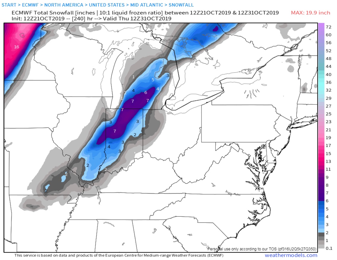
1993 anyone? This is the 240hr Operational Euro which is painting some snow the morning of Halloween. I know it probably won't happen but I love winter weather and I'm glad it's that time of the year where hour 240 is always interesting somewhere :-) . There was a huge cold air outbreak around Halloween 1993. Snowed as far south as Montgomery Alabama that day.
++++++++++++++++++++++++++++++
Re: Re: Re: Re: Natural Gas October 14, 2019
By metmike - Oct. 21, 2019, 7:42 p.m.
Thanks Grant!
I remember that one vividly and it was actually the day before Halloween here in Evansville, Oct 30th which was a Saturday.
I went sledding with the kids and we made a snow man in the backyard.
I went Trick or Treating with the kids the next day with the snow on the ground and sub freezing temps.
I'm guessing our snow was just over 6 inches and it was a record for October but will retrieve the records.
Snow storms have always been my favorite too. When I moved down here in 1982 from Cincinnati(6 months) after living in Michigan, it was thought to be temporary and farther south than I would have preferred because of less snow(but I was going to any tv station that would hire me-including applying at Fairbanks Alaska)
+++++++++++++++++++++
By metmike - Oct. 21, 2019, 7:55 p.m.
OK, we got a total of 4.6 inches from that event, 3.7 inches fell on October 30th(most of which was very early in the morning.
The 3.7 inches is a record for 24 hours in October.
Our record snow for November is 6.9 inches set on the 28th in 1958.
That snow event in 1993 is the biggest snow in the records until the event on Nov 28th almost a month later to show how anomalous the Oct 1993 event was.
Go to snowfall at the link below
https://www.weather.gov/pah/EvansvilleDailyNormalsAndRecords
Maybe I can retrieve some wx maps of that storm now.
+++++++++++++++++++++++++++
By metmike - Oct. 21, 2019, 7:58 p.m.
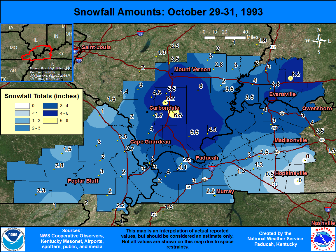
https://www.weather.gov/pah/SnowOct29-31_1993
OK, even better:
+++++++++++++++++++++++++++++++++
By metmike - Oct. 21, 2019, 8:06 p.m.
https://www.youtube.com/watch?v=uzosOgVFQJY
A surprise snowstorm hit the Cincinnati area on the weekend of Oct. 30-31, 1993. When it ended on Sunday, there were 6.2 inches on the ground, marking the first White Halloween on record in the region. The 5.9 inches of snow on Saturday – Halloween Eve - was a record for a single day in October. The next day, the coldest high temperature for Halloween - just 36 degrees – kept a lot of trick-or-treaters home.
+++++++++++++++++++++++++++++++++++++++++++++++++
Re: Re: Re: Re: Re: Re: Re: Re: Natural Gas October 14, 2019
By cutworm - Oct. 21, 2019, 10:42 p.m.
I remember taking the kids Trick or Treating that year! Great memories! Should have had abominable snow man costumes!
+++++++++++++++++++++++++++++++
By metmike - Oct. 31, 2019, 12:34 p.m.
++++++++++++++++++++++
By bowyer - Oct. 31, 2019, 5:48 p.m.
We got our Halloween snowstorm here. I think the most we've ever had here on Oct. 31 was a trace. I measured almost 6 inches on the ground in sheltered areas. There has been some drifting this afternoon also. Lots of corn and beans still in the field in the area.
+++++++++++++++++++++++++++++++++++++++++
Re: Re: Re: Re: Weather Halloween
By wxgrant - Oct. 31, 2019, 7:25 p.m.
We had snow flurries in Cape Girardeau today. Numerous reports of flurries on my area.
++++++++++++++++++++++++++
Re: Re: Re: Re: Re: Weather Halloween
By metmike - Oct. 31, 2019, 11:51 p.m.
We had some flurries too here in southwest IN.
Tuesday weather:
