Happy April 16th! Do something to make somebody feel LUCKY today. Don't just think about it........do it. Then think about it.............and how you just made somebody's world a tiny bit greener.
Our local chess tournament last month got some great coverage. I'm extraordinarily proud of the kids and also the adults that helped run this event:
Scroll down and enjoy the latest comprehensive weather to the max...... occurring because of the natural physical laws in our atmosphere. Big storm this week with heavy rain and severe weather. This is going to really start to matter for corn planting, that, ideally should begin in earnest within 3 weeks.............but probably not this year in many places. Overnight models were a bit drier again and quite a bit warmer again compared to a couple of days ago(improving planting prospects vs then)
Here are the latest hazards across the country.
Purple/Pink/blue on land is cold/Winter weather. Brown is wind, Green is flooding. Gray is fog. Reddish is a red flag advisory.
Go to the link below, then hit the location/county on the map for details.
https://www.spc.noaa.gov/ Go to "hazards"

Wind map Hit this with your cursor:


Wind map Press down on this on the left with your cursor!


Current Jet Stream

Winter Weather
https://www.wpc.ncep.noaa.gov/wwd/winter_wx.shtml

Snowfall the next day:
Forecast Hour: 027
Image URL: http://mag.ncep.noaa.gov/data/nam/12/nam_namer_027_snodpth_chng.gif

| Low Temperatures Tomorrow Morning |

Huge warm up Tuesday!


Highs for days 3-7:
Chilly late this week............then big warming.


Average Temperature anomalies for days 3-7:
Overall at or above average but with a chilly start/early in the period .
https://www.wpc.ncep.noaa.gov/medr/medr_mean.shtml


Weather maps for days 3-7 below
Big storm this week in the Northeast on Friday! New, weaker systems next week.

Last 24 hour precip top map
Last 7 day precip below that
https://www.wunderground.com/maps/precipitation/daily


Liquid equivalent precip forecasts for the next 7 days are below.
A large area of moderate/heavy rains in the middle/late part of this week.
For the 2nd day in a row, not as wet as yesterday for the Central belt.
Day 1 below:
http://www.wpc.ncep.noaa.gov/qpf/fill_94qwbg.gif?1526306199054

Day 2 below:
http://www.wpc.ncep.noaa.gov/qpf/fill_98qwbg.gif?1528293750112

Day 3 below
http://www.wpc.ncep.noaa.gov/qpf/fill_99qwbg.gif?1528293842764

Days 4-5 below:
http://www.wpc.ncep.noaa.gov/qpf/95ep48iwbg_fill.gif?1526306162

Days 6-7 below:
http://www.wpc.ncep.noaa.gov/qpf/97ep48iwbg_fill.gif?1526306162

7 Day Total precipitation below:
http://www.wpc.ncep.noaa.govcdx /qpf/p168i.gif?1530796126

Excessive Rainfall Forecasts
Mesoscale Precipitation Discussions
Current Day 1 Forecast Valid 12Z 04/15/19 - 12Z 04/16/19 |
Day 1 Threat Area in Text Format
| Day 2 and Day 3 Forecasts |
Current Day 2 Forecast Valid 12Z 04/16/19 - 12Z 04/17/19 |
Day 2 Threat Area in Text Format
Current Day 3 Forecast |
Severe Storm Outlook
https://www.spc.noaa.gov/products/outlook/
| Current Convective Outlooks | |
|---|---|
| Updated: Mon Apr 8 12:48:09 UTC 2019 (2h 51m ago) | |
Current Day 1 Outlook | Forecaster: Thompson/Leitman Issued: 08/1243Z Valid: 08/1300Z - 09/1200Z Forecast Risk of Severe Storms: Slight Risk |
Current Day 2 Outlook | Forecaster: Dial Issued: 08/0549Z Valid: 09/1200Z - 10/1200Z Forecast Risk of Severe Storms: Marginal Risk |
Current Day 3 Outlook | Forecaster: Dial Issued: 08/0733Z Valid: 10/1200Z - 11/1200Z Forecast Risk of Severe Storms: Slight Risk |
Current Day 4-8 Outlook | |
Current Dew Points
Moisture surging northward.

Latest radar loop
http://www.nws.noaa.gov/radar_tab.php

| Full resolution version loop (3400x1700 pixels - 2.2mb) |

Go to: Most Recent Image
You can go to this link to see precipitation totals from recent time periods:
https://water.weather.gov/precip/
Go to precipitation, then scroll down to pick a time frame. Hit states to get the borders to see locations better. Under products, you can hit "observed" or "Percent of normal"
+++++++++++++++++++++++++++++++++++++++++++++++
Precipitation compared to average for the last 7, 14, 30 and 60 days.
IT's BEEN DRYING OUT IN THE SOUTH BUT IT WILL GET WET AGAIN THERE!
Usually not updated for previous day until late the next day.
https://www.atmos.illinois.edu/~snodgrss/Ag_Wx.html


Soilmoisture anomaly:
These maps sometimes take a day or 2 to catch up to incorporate the latest data. Still too wet over a large area.
https://www.cpc.ncep.noaa.gov/products/Soilmst_Monitoring/US/Soilmst/Soilmst.shtml#
![]()


Currently, there is 0% of the Cornbelt/Midwest with drought. There is no place even slightly dry there.
The South has been really drying out recently but heavy rains coming up should wipe out some of the dryness in that area.
The market will be keying on precip forecasts for planting concerns for the next month.
https://droughtmonitor.unl.edu/

The top map is the Canadian ensemble average, the maps below are the individual members that make up the average
+++++++++++++++++++++++++++++++++++++++++
Each member is like the parent, Canadian model operational model.......with a slight tweek/variation in parameters. Since we know the equations to represent the physics of the atmosphere in the models are not perfect, its useful to vary some of the equations that are uncertain(can make a difference) to see if it effects the outcome and how.
The average of all these variations(ensembles) often yields a better tool for forecasting. It's always more consistent. The individual operational model, like each individual ensemble member can vary greatly from run to run.........and represent an extreme end of the spectrum at times. The ensemble average of all the members, because it averages the extremes.............from opposite ends of the spectrum.........changes much less from run to run.
End of week 2....................0z ensembles from TUESDAY:
Analysis starting from a week ago, ending with today:
Last week+ of analysis, starting with the day farthest in the past:
Last Monday: The mean/average is zonal but many solutions don't look like the average, they have an amplification of the pattern somewhere(possibly just transient). Majority are not nearly as wet as last week. No major cold intrusions.
Tuesday: The mean is zonal and mild but the flow could still be fairly active......just not featuring excessive rain events because of being progressive.
Wednesday: Very wide spread in solutions from very strong and wet southern stream dominant(a slight majority) to dry and chilly northern stream, new pattern. The Canadian ensembles is by far the wettest for late week 2 as the other models are much drier today.
Thursday: The mean looks fairly zonal again but the individual solutions which offset each other in the average have a wide spread. Still looking for a potential drier pattern but there are still some with enough southern stream to cause it to be wet............if those solutions are correct.
Friday: The mean and also individual solutions are looking zonal and drier..........this is the driest looking model for week 2.
Saturday: Mean is still zonal but maybe closer to average precip now and not as dry. Just over half the solutions actually would have above average precip, less than half drier.
Sunday: Zonal but active mean with mild temps. After a dry period of several days possible early in week 2(from the pattern described recently/above and the progression of days in the forecast, it looks wet again later in week 2.
Monday: The big change on the mean today is the upper level heights(ridging) building from the south into the Midwest compared to yesterday. At the very least, this would mean warm temperatures. This could also deflect/effect the storm track/jet stream.
Tuesday: Warm solutions on majority, with upper level high in the Southeast on numerous solutions and an active southern stream on some solutions that still carry the risk of wet weather in the Plains.
360h GZ 500 forecast valid on May 01, 2019 00 UTC


0Z GFS Ensembles at 2 weeks:
Analysis, starting with the oldest, ending with the most recent:
Last Thursday: GFS ensembles continue VERY wet from a powerful southern stream. Southern Plains to points east/northeast have the highest potential for excessive rains.
Friday: This model still has a pretty potent southern stream and deep upper level trough on many solutions.......favored towards the west.
Saturday: Not as wet with less upper level ridging in the Southeast.
Sunday: Not as wet again, with regards to the threat of excessive rain events, without much ridging in the Southeast. However, It still could be quite wet in some places and very active.
Monday: Still not nearly as wet as last week with several solutions taking the southern stream out as a major factor.
Tuesday: Some solutions shift to a much drier pattern change. Some have some northern stream flow. Uncertainty for late week 2, especially late.
Wednesday: Still much disagreement but most take away the wet southern stream connection and dry things out in the Midwest. A few bring in some potential northern stream connection and a decent slug of cold.
Thursday: The GFS ensembles majority are much drier here at the end of week 2. Almost half half of them have a strong ridge in the west /Rockies that shuts down the moisture.
Friday: The big upper ridge in the west solution that had been growing has almost vanished, half the solutions have an upper level low there today............so its wetter than yesterday and potentially active on half the solutions.
Saturday: Individual solutions continue to look wetter than a couple of days ago but some are drier too. Low confidence because of the spread. The mean has precip a tad above average.
Sunday: Precip is looking wetter again.
Monday: Definitely looks pretty warm on most solutions. Rains are uncertain. Depends on if we have an active flow or the jet stream is diverted away from the Midwest or only pays brief visits.
Tuesday: Drier and no southern stream aimed towards the Midwest. Very warm.

Ensemble mean(average of all the individual solutions above)
Last Tuesday: Anomalies changing quite a bit. A new positive one in Northwest Canada across Alaska(another around Greenland) with the positive anomaly in the Northeast that was the main one last week, being replaced with a negative anomaly in Southeast Canada. This suggests the increasing potential for chilly weather in mid April. It could also dry things out in the Midwest by suppressing the southern stream farther south, into the S.Plains.
Wednesday: New anomaly centers continue from yesterday. Positive Northwest Canada to Alaska, negative downstream to the southeast. Should mean cooler mid April weather. Will it also dry things out in the Upper Midwest/N.Plains and suppress the southern stream south? Watch the upper level ridge in the Southeast. If it holds, it will be very wet in the S.Plains.
Thursday: Anomalies in the high latitudes, N.Alaska across the N.Pole to NE.Canada and negative anomolies in the S.Plains increase chances for cold in Canada to travel south but the big story is going to be southern stream energy.........and where its aimed. This will be defined by the negative anomaly in the vicinity of the S.Plains and positive anomaly in the far Southeast(which pumps up the moisture and blocks the progression of the large scale upper level low to its west). How wet it gets will be influenced by how amplied these features are.
Friday: High latitude positive anomaly is undercut by Pacific flow/disconnected from a downstream negative anomaly which would establish a couplet for moving cold air south. Still a negative anomaly in the Southern Plains and vicinity associated with the Southern Stream.
Saturday: Southern stream negative anomaly shifting west of Plains, slight positive anomaly in the Midwest suggests potentially much drier....and warmer.
Sunday: No big anomaly centers to key off of. Slightly positive in the east and negative in the Plains still suggests at least some rain.
Monday: Weak anomalies from the mean, much because the disagreements average out.
Tuesday: Positive anomaly growing a tad along the West Coast. Slight negative anomaly in Southeast Canada. If this amplifies, it helps shut down the big precip events.
Wednesday: The noted anomaly from yesterday, though still not impressive has a smideon more amplitude today.....which keeps my forecast for a drier pattern change in week 2 valid. If this leads to a ridge west/trough east couplet, it would also cool things down in the East.............and potentially much cooler in the Midsection on some guidance.
Thursday: Modest ridge West/trough East anomaly keeps me leaning drier later this month and at this end of week 2 time frame. This would also cause it to be cool in the Midwest/East, with warmth in the West.
Friday: The positive anomaly in the west is completely gone today. No very strong anomalies in the US, with a weak negative one off the East Coast.
Saturday: Weak anomalies that have been shifting every day. Modest positive anomalies across much of the US, except the East Coast would mean mild to warm.
Sunday: Weak positive anomaly in the N. Plains. Great uncertainty.
Monday: Pretty decent positive anomaly across the northern half of the US into Southeastern Canada..........so warm temps. Not sure on rains but its NOT an excessive rain set up in the Midwest.
Tuesday: Even bigger positive anomaly NorthCentral US. High confidence for warmth. This would shutdown the moisture to some places................possibly forcing the southern stream to take a track that keeps it from being aimed at the Midwest.
NCEP Ensemble t = 360 hour forecast 
Latest, updated graph/forecast for AO and NAO here, including an explanation of how to interpret them.
Previous analysis, with the latest day at the bottom for late week 2 period.
Last Saturday: AO really plunges now, to moderately negative. NAO to around 0 from positive and PNA a bit positive. Keep this up with gusto and the mid April forecast might turn cooler but we're a long ways from that and they indices are not as powerful for northern stream insight/affect on the US in the warmer months.
Sunday: AO drops to negative, not as much as yesterday..............less cold threat. NAO has a very wide spread on both sides of 0. PNA slightly positive.
Monday: AO a bit negative. NAO drops to near 0. PNA a tad positive. Weak.
Tuesday: Stronger signals today. AO more negative......and favorable for cold air to be flushed from high latitudes, towards the mid latitudes. NAO now negative........more favorable for penetrating of cold into the Midwest/Northeast. PNA is slightly positive and increasing which also assists with those indices in increasing some chilly risks in mid April and beyond.
Wednesday: AO goes negative much sooner and in week 1, then drifts to less negative at the end of 2 weeks. NAO spikes to negative then recovers to less negative at the end of week 2. PNA slightly positive. Turning cooler next week.
Thursday: AO plunges to VERY low values next week with the NAO also diving much lower into negative territory. This, in tandem with much cooler forecasts as air from higher latitudes makes its way into middle latitudes. These indices bounce a bit at the end of 2 weeks. If this were January, it would be pretty bullish for ng. The PNA is a tad positive.
Friday: Negative AO bounces up towards zero near the end of 2 weeks, just like the NAO. PNA is a tad positive.
Saturday: Negative AO and NAO with chilly weather late week 1/early week 2, then they recover towards zero and temperatures warm. PNA.close to 0.
Sunday: AO, NAO and PNA all close to 0 in 2 weeks.
Monday: AO and PNA near 0, NAO slightly negative.......not major factors.
Tuesday: AO and NAO a tad negative. PNA near 0.
Wednesday. AO, NAO and PNA all near 0.
Thursday: Data incomplete but looks like they are all close to 0 at the end of 2 weeks.
Friday: AO and PNA near 0, NAO is leaning positive at the end of 2 weeks.......nothing noteworthy.
Saturday: AO, NAO, PNA all near 0 at the end of week 2.
Sunday: All near 0.
Monday: All near 0.
Tuesday: AO and PNA near 0. NAO positive........warm influence.
The link below, now has the PNA index added at the bottom:
https://www.marketforum.com/forum/top
Spring outlook from the NWS.
This is a HUGE deal to the grains, especially corn because planting, ideally can get started in a big way by early May and needs to be done in May.
Many traders/forecasters are drawing similarities to 1993 and the historic flooding of that year because that was the last time conditions were like this.
Each year is different. One thing is certain. The market will NOT be concerned about drought during planting and the early parts of the growing season. Surface and subsoil moisture is completely recharged almost everywhere.
")
National Weather Service 6-10 day, 8-14 day outlooks.
Expect widespread warmth!!
Temperature Probability | |
Precipitation Probability | |
| the 8-14 day outlooks ArchivesAnalogsLines-Only FormatGIS Data | |
Temperature Probability | |
 | |
Previous discussions:
By WxFollower - April 5, 2019, 12:43 p.m.
It is getting quite dry in much of the SE US. So, rain is needed. Upcoming warmth will exacerbate the problem.
++++++++++++++++++++++
By metmike - April 5, 2019, 7:53 p.m.
Larry,
I've noted how dry that its been recently in the South and it's too dry now in a growing area(I just updated the drought monitor map above).
The pattern coming up could take care of that quickly if the zone of heavy rains is far enough east.
+++++++++++++++++++++
Re: Re: Re: Re: Weather Sunday
By mcfarm - April 8, 2019, 10:25 a.m.
metmike, big talk of a 12 to 16 inch snow fall coming to the upper midwest......are you predicting th same?
+++++++++++++++++++++++++++++++++
By metmike - April 8, 2019, 11:16 a.m.
Yes mcfarm!
Looks like SD to MN will have the heaviest snow. Thanks much for pointing this out.
Email: meteormike@msn.com | IP Address: None | Cookie ID: None
Re: Re: Re: Re: Weather Tuesday
0 likes
By metmike - April 9, 2019, 4:01 p.m.

+++++++++++++++++++++++++++++++++++++++++++++++++++++++
By cliff-e - April 9, 2019, 5:48 p.m.
Looks like another "Bomb Cyclone" Winter storm headed for Minnesnowta with up to 30" snow and 50 mph wind gusts. On April 14 2018 we had 23" wet heavy snow that delayed planting...this time around we have wetter soils with only half of our Fall tillage completed so many of us will consider the prevented plant option if this storm comes to fruition.
++++++++++++++++++++++++++++++++++++++++++++++++++++++++++++++++++++
By metmike - April 9, 2019, 10:50 p.m.
Thanks cliff,
I remember those poor early Spring planting conditions for Minnesota last year and you stating the same thing about your intentions for the prevent planting option well into May.
I will make the same prediction as last year............that you get your crop planted, 90% chance.
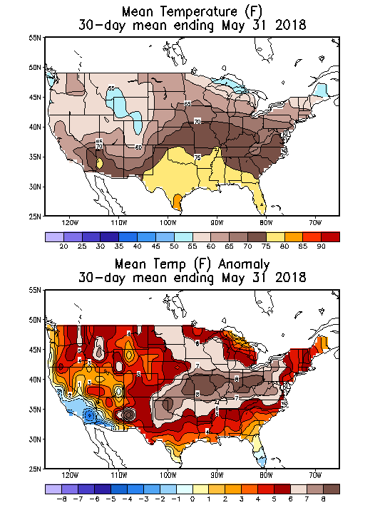
How did last years similar snowstorm and cold/wet early Spring affect the planting? On June 3, 2018, 98% of the Minnesota corn was planted which was actually 2% ahead of the average for that date..........thanks to some very warm/dry weather in much of May.
Temps were more than 6 degrees above normal for the entire month of May last year!!
How did the late snowstorm and cold/wet Spring last year effect development of the MN crop last year thru pollination?
USDA August `13, 2018 crop condition: 77% Good/Excellent in MN. 2% poor.
Crop yield estimate by state after pollination:

It's not likely that May will turn as warm and dry as it did last year which allowed for the crop to be planted quickly but each year is different. Hopefully this will be another great one for you!
It really is getting harder and harder to hurt these crops with increasing CO2 and beneficial climate change. Hopefully you'll have another bin buster or close to it again even if early planting is not going to be in the cards for the 2nd year in a row. By historical standards, we are way overdue for some major adversity during the growing season but climate change has changed those historical odds for adversity from drought during the growing season(the biggest risk to crops) to being lower than before.
++++++++++++++++++++++++++++++++++++++++++++++++
By cliff-e - April 10, 2019, 6:47 a.m.
It's now April 2019...our rivers have been at flood stage for nearly 3 weeks already and our soil profile is definitely wetter as we now hear our basement sump pump running this year vs. last year when it never ran during the April 2018 floods. And we're still hearing of producers without operating credit for this year due to projected negative cash flows.
++++++++++++++++++++++++++++++++++++++++++++
Re: Re: Re: Re: Weather Wednesday
By metmike - April 10, 2019, 12:25 p.m.
Thanks cliff,
Yep, all those facts are true about how the weather HAS(past tense) affected your soils and this current snow IS current tense about to affect things in a huge negative way. The bearish USDA report for corn yesterday didn't help any either. Sorry that things are so messed up for you right now.
My forecast is for it to start drying out up there later in April FUTURE tense which is what matters now.........and for which there is the most uncertainty.
For all I know, May could end up being the wettest May in history for MN because the models/guidance we use just don't have the skill to forecast that far out............which in this case means everything to your planting.
Let's hope that, instead it turns very warm and dry like it did in May 2018.
+++++++++++++++++++++++++++++++
By metmike - April 10, 2019, 12:27 p.m.
Craig Solberg @CraigSolberg 4h4 hours ago
Palmer drought index for March for the Corn Belt easily the highest on record. Maybe makes a case that the Corn Belt is wetter now than it has EVER been for this time of year?

Previous discussions:
By WxFollower - April 5, 2019, 12:43 p.m.
It is getting quite dry in much of the SE US. So, rain is needed. Upcoming warmth will exacerbate the problem.
++++++++++++++++++++++
By metmike - April 5, 2019, 7:53 p.m.
Larry,
I've noted how dry that its been recently in the South and it's too dry now in a growing area(I just updated the drought monitor map above).
The pattern coming up could take care of that quickly if the zone of heavy rains is far enough east.
+++++++++++++++++++++
Re: Re: Re: Re: Weather Sunday
By mcfarm - April 8, 2019, 10:25 a.m.
metmike, big talk of a 12 to 16 inch snow fall coming to the upper midwest......are you predicting th same?
+++++++++++++++++++++++++++++++++
By metmike - April 8, 2019, 11:16 a.m.
Yes mcfarm!
Looks like SD to MN will have the heaviest snow. Thanks much for pointing this out.
Email: meteormike@msn.com | IP Address: None | Cookie ID: None
Re: Re: Re: Re: Weather Tuesday
0 likes
By metmike - April 9, 2019, 4:01 p.m.
+++++++++++++++++++++++++++++++++++++++++++++++++++++++
By cliff-e - April 9, 2019, 5:48 p.m.
Looks like another "Bomb Cyclone" Winter storm headed for Minnesnowta with up to 30" snow and 50 mph wind gusts. On April 14 2018 we had 23" wet heavy snow that delayed planting...this time around we have wetter soils with only half of our Fall tillage completed so many of us will consider the prevented plant option if this storm comes to fruition.
++++++++++++++++++++++++++++++++++++++++++++++++++++++++++++++++++++
By metmike - April 9, 2019, 10:50 p.m.
Thanks cliff,
I remember those poor early Spring planting conditions for Minnesota last year and you stating the same thing about your intentions for the prevent planting option well into May.
I will make the same prediction as last year............that you get your crop planted, 90% chance.
How did last years similar snowstorm and cold/wet early Spring affect the planting? On June 3, 2018, 98% of the Minnesota corn was planted which was actually 2% ahead of the average for that date..........thanks to some very warm/dry weather in much of May.
Temps were more than 6 degrees above normal for the entire month of May last year!!
How did the late snowstorm and cold/wet Spring last year effect development of the MN crop last year thru pollination?
USDA August `13, 2018 crop condition: 77% Good/Excellent in MN. 2% poor.
Crop yield estimate by state after pollination:
It's not likely that May will turn as warm and dry as it did last year which allowed for the crop to be planted quickly but each year is different. Hopefully this will be another great one for you!
It really is getting harder and harder to hurt these crops with increasing CO2 and beneficial climate change. Hopefully you'll have another bin buster or close to it again even if early planting is not going to be in the cards for the 2nd year in a row. By historical standards, we are way overdue for some major adversity during the growing season but climate change has changed those historical odds for adversity from drought during the growing season(the biggest risk to crops) to being lower than before.
++++++++++++++++++++++++++++++++++++++++++++++++
By cliff-e - April 10, 2019, 6:47 a.m.
It's now April 2019...our rivers have been at flood stage for nearly 3 weeks already and our soil profile is definitely wetter as we now hear our basement sump pump running this year vs. last year when it never ran during the April 2018 floods. And we're still hearing of producers without operating credit for this year due to projected negative cash flows.
++++++++++++++++++++++++++++++++++++++++++++
Re: Re: Re: Re: Weather Wednesday
By metmike - April 10, 2019, 12:25 p.m.
Thanks cliff,
Yep, all those facts are true about how the weather HAS(past tense) affected your soils and this current snow IS current tense about to affect things in a huge negative way. The bearish USDA report for corn yesterday didn't help any either. Sorry that things are so messed up for you right now.
My forecast is for it to start drying out up there later in April FUTURE tense which is what matters now.........and for which there is the most uncertainty.
For all I know, May could end up being the wettest May in history for MN because the models/guidance we use just don't have the skill to forecast that far out............which in this case means everything to your planting.
Let's hope that, instead it turns very warm and dry like it did in May 2018.
+++++++++++++++++++++++++++++++
By metmike - April 10, 2019, 12:27 p.m.
Craig Solberg @CraigSolberg 4h4 hours ago
Palmer drought index for March for the Corn Belt easily the highest on record. Maybe makes a case that the Corn Belt is wetter now than it has EVER been for this time of year?