Posts below started on Wednesday afternoon, so the oldest discussions are at the top......newest at the bottom. Most maps/links posted below are updated automatically, despite the older discussion times..........enjoy.
For the complete weather that has much more go here:
https://www.marketforum.com/forum/topic/13052/
Note at the first link below that there are several tropical systems in the Atlantic. This is the peak hurricane season and not extremely unusual.
https://www.nhc.noaa.gov/graphics_at1.shtml?cone#contents
https://www.nhc.noaa.gov/text/refresh/MIATCDAT1+shtml/101450.shtml?


Total 7 day rains below
Look at the latest path for Florence based on the just out 12z European model for 24 hour periods starting Friday and going out the next week. It drops down into Northern Georgia!
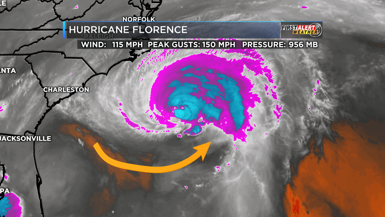
There has been a fairly significant change in the forecast strength of Florence today.
The last NHC update here a few minutes ago, notes that Florence has WEAKENED and not strengthened as expected. Currently, it's down to 120 mph. This weakening has been extrapolated out in the latest forecast, which now only takes the storm up to 125 mph vs yesterday, when it was expected to hit 155 mph.
Water Vapor shows dry air wrapping into the circulation. Looking back at the earlier model runs, they all kept this dry air outside the circulation. Hopefully this trend continues.
This is great news Grant as the storm has continued to weaken down to 110 mph as of the last update. The National Hurricane Center continues to dial down the intensity forecast, now just maintaining the 110 mph strength, below major hurricane strength during the next 24 hours.
By Friday Morning, the hurricane will be encountering enough land to weaken even more. If the center/eye does cross over the coast on Friday, it will weaken fairly quickly and be just a tropical storm by very late Fri/Fri Night.
The threat for very high winds from a cat. 4 hurricane has dropped significantly and we may get this thing down to a cat. 1 as its hitting the coast, however there will still be a major storm surge and torrential rains that could amount to over 20 inches near the coast to inland around 50 miles. It's conceivable that 30 inches of rain might fall in a couple of locations from Thursday Night thru Sunday Morning.
Forecast Hour: 144
Image URL: http://mag.ncep.noaa.gov/data/gfs/00/namer/precip_ptot/gfs_namer_144_precip_ptot.gif

Not much change overnight with Florence still at 110 mph and not expected to get much stronger, while approaching the coast. Rains well over a foot WILL occur just inland.
Florence has weakened just a smidgen more this morning to 105 mph which keeps it as a category 2 storm.
Torrential rains along the coast and just inland the next few days are not exactly correlated to these downgraded current winds speeds/strength. Just because the forecast peak winds, that were once as high as 155 have dropped lower(fortunately) does not mean that rain totals will drop proportionately.
20+ inches of rains in a few locations is still a good bet.
This was the last 0z European model forecast:
The last 12z GFS operational model total rains below. Its almost impossible to see on this map but it looks like there is a bright yellow speck, barely inland in North Carolina which represents 50 inches of rain.
This would be possible if Florence stalled out over North Carolina from Fri-Sunday........which is possible.
Forecast Hour: 156
Image URL: http://mag.ncep.noaa.gov/data/gfs/12/namer/precip_ptot/gfs_namer_156_precip_ptot.gif

Florence has continued to weaken a bit, now down to 100 mph and barely a cat. 2 hurricane.
The threat for extreme rains along the coast and just inland of 25+ inches remains, regardless of this recent weakening.
Here's the latest track of Florence from the 12z European model:
From Weather Thursday:
https://www.marketforum.com/forum/topic/12892/
By metmike - Sept. 13, 2018, 10:34 a.m.
Here is the latest radar image. Florence will be stealing the show for days. Radars lighting up eastern North Carolina with spiral rain bands on the periphery, outside of the eye wall.
http://www.nws.noaa.gov/radar_tab.php


Florence down to 90 mph.
Here is a NWS office close to the center. WInds have been gusting above 80 mph for the last several hours at Moorehead City, NC:
Current conditions at
Lat: 34.9°NLon: 76.88°WElev: 26ft. 
Heavy Rain and Windy
| Humidity | NA |
| Wind Speed | E 46 G 81 mph |
| Barometer | 29.42 in (996.1 mb) |
| Dewpoint | N/A |
| Visibility | 2.00 mi |
| Last update | 13 Sep 10:54 pm EDT |
How often do you see a forecast like the one below?
Tonight
Hurricane conditions expected. Showers and possibly a thunderstorm. Some of the storms could produce heavy rainfall. Low around 75. Chance of precipitation is 100%. New rainfall amounts between 3 and 4 inches possible.
Friday
Hurricane conditions expected. Showers and possibly a thunderstorm. Some of the storms could produce heavy rainfall. High near 81. Chance of precipitation is 100%. New rainfall amounts in excess of 4 inches possible.
Friday Night
Tropical storm conditions expected, with hurricane conditions possible. Showers and possibly a thunderstorm. Some of the storms could produce heavy rainfall. Low around 75. Chance of precipitation is 100%. New rainfall amounts between 2 and 3 inches possible.
Saturday
Showers and possibly a thunderstorm. Some of the storms could produce heavy rainfall. High near 82. Windy, with a southeast wind 30 to 36 mph, with gusts as high as 48 mph. Chance of precipitation is 90%. New rainfall amounts between 1 and 2 inches possible.
Saturday Night
Showers and possibly a thunderstorm. Some of the storms could produce heavy rainfall. Low around 74. Breezy, with an east wind 16 to 22 mph, with gusts as high as 33 mph. Chance of precipitation is 80%. New rainfall amounts between 1 and 2 inches possible.
Sunday
Showers likely and possibly a thunderstorm.
Florence still 90 mph and barely on the coast, soon to make landfall or already has. The cat. 1 hurricane is slowing down which will cause the torrential rains to pound the same areas.
The center of Florence, has apparently been just barely on the coast for the last few hours. Interaction with land has weakened it to 80 mph, which is a minimal hurricane.
Already, as much as 14 inches of rain has fallen in some locations along the coast and just inland.
Another 14 inches is possible in the next 24 hours as Florence moves extremely slow to the sw/west and weakens to a tropical storm.
Florence is no longer a hurricane..........now weakened to a tropical storm.
Rains in excess of 20 inches have fallen in a couple of spots just inland with another 15 inches possible in those spots.
A rain max total of 40 Inches is possible in the wettest spot along the coast because of the very slow movement. Lesser amounts will fall inland but still heavy by any standards.
Florence down to 65 mph and moving slightly south of west into far northeast SC. The track has been adjusted into central SC by this time Saturday, then it will start turning to the right/north of west and be along the TN/NC border by this time Sunday(48 hours), then turn north and be around the OH/WV border in 72 hours/Mon pm, as it gradually turns more and more to the right and is picked up by a mid latitude weather system and be moving northeast to east on Tuesday thru PA and passing over Mikekempt house shortly after noon on Tuesday. Then going bye bye for good. on Wedneday and good riddens after more than 2 weeks of being on weather maps.
Trivia question: When was Florence dubbed a tropical storm?
How long did the longest lasting tropical storm last?
The wind history for Florence is below:
Florence in Northern SC, down to 45 mph and about to weaken to depression category, below 39 mph.
Still torrential rains all day Saturday to the right of the track(north).

![[Image of cumulative wind history]](https://www.nhc.noaa.gov/storm_graphics/AT06/refresh/AL062018_wind_history+png/032615_wind_history.png)