Tropical Storm Arthur 6-17-26
2 responses | 0 likes
Started by metmike - June 17, 2026, 6:45 p.m.


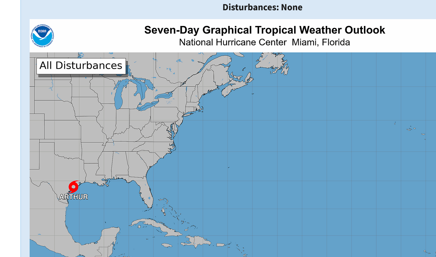
Minimal tropical storm Arthur will weaken and dissipate on Thursday but cause big rains along the Central Gulf Coast.

https://www.nhc.noaa.gov/gtwo.php?basin=atlc&fdays=7


Get all the comprehensive weather here:

https://www.marketforum.com/forum/topic/83844/


Comments
By metmike - June 17, 2026, 6:50 p.m.
Like Reply

My family just returned from a vacation in Destin, FL 8 days ago.

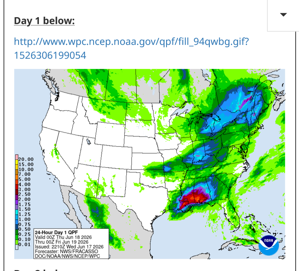
Thank you tropical storm Arthur for waiting until this week to hit!!!

https://forecast.weather.gov/MapClick.php?x=282&y=160&site=mob&zmx=&zmy=&map_x=281&map_y=160


Current conditions at            

Destin, Destin-Ft. Walton Beach Airport (KDTS)

            Lat: 30.39°NLon: 86.47°WElev: 20ft.                                                                                


Local Forecast OfficeMore Local Wx3 Day HistoryHourly Weather Forecast

                                                 Extended Forecast for                                         

Flood Watch

High Surf Advisory

  • This Afternoon
    This Afternoon: A 20 percent chance of showers and thunderstorms.  Mostly cloudy, with a high near 86. South wind around 10 mph, with gusts as high as 20 mph.
    High: 86 °F
    Slight Chance
    T-storms
  • Tonight
    Tonight: A chance of showers and thunderstorms, then showers likely and possibly a thunderstorm after 4am.  Mostly cloudy, with a low around 77. South wind around 10 mph, with gusts as high as 20 mph.  Chance of precipitation is 60%. New rainfall amounts of less than a tenth of an inch, except higher amounts possible in thunderstorms.
    Low: 77 °F
    Chance
    Showers then
    Showers
    Likely
  • Thursday
    Thursday: Showers and possibly a thunderstorm before 1pm, then showers and thunderstorms, mainly after 1pm. Some of the storms could produce heavy rainfall.  High near 84. South wind around 15 mph, with gusts as high as 25 mph.  Chance of precipitation is 90%. New rainfall amounts between three quarters and one inch possible.
    High: 84 °F
    Heavy Rain
  • Thursday Night
    Thursday Night: Showers and thunderstorms before 10pm, then showers likely and possibly a thunderstorm between 10pm and 11pm, then a chance of showers and thunderstorms after 11pm. Some of the storms could produce heavy rainfall.  Low around 78. South southwest wind 10 to 15 mph, with gusts as high as 25 mph.  Chance of precipitation is 80%.
    Low: 78 °F
    Heavy Rain
    then Chance
    T-storms
  • Juneteenth
    Juneteenth: Showers and possibly a thunderstorm before 1pm, then showers and thunderstorms likely between 1pm and 4pm, then showers likely and possibly a thunderstorm after 4pm.  High near 88. Southwest wind around 10 mph, with gusts as high as 20 mph.  Chance of precipitation is 80%.
    High: 88 °F
    Showers then
    T-storms
  • Friday Night
    Friday Night: A 50 percent chance of showers and thunderstorms.  Mostly cloudy, with a low around 77.
    Low: 77 °F
    Chance
    T-storms
  • Saturday
    Saturday: Showers and possibly a thunderstorm before 1pm, then showers and thunderstorms likely after 1pm.  High near 88. Chance of precipitation is 80%.
    High: 88 °F
    T-storms
  • Saturday Night
    Saturday Night: A 20 percent chance of showers and thunderstorms before 1am.  Partly cloudy, with a low around 77.
    Low: 77 °F
    Slight Chance
    T-storms
  • Sunday
    Sunday: A 20 percent chance of showers and thunderstorms.  Mostly sunny, with a high near 88.
    High: 88 °F
    Slight Chance
    T-storms
By metmike - June 18, 2026, 6:47 a.m.
Like Reply

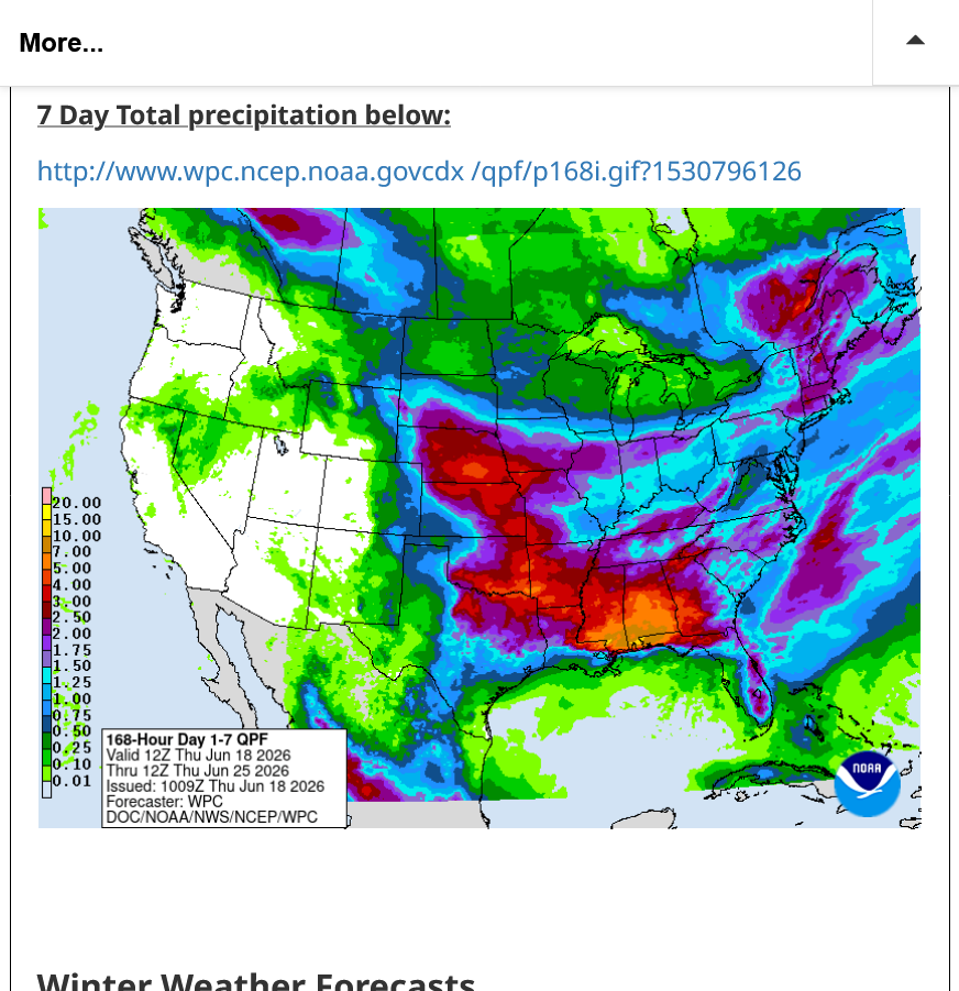
That yellow dot along the FL coast on the total rainfall map below represents 10 inches of rain and is pretty close to where we were staying less than 2 weeks ago!

https://www.wpc.ncep.noaa.gov/qpf/p168i.gif?1530796126