Previous thread:
UAH Global Temperature March 2026
Started by metmike - April 4, 2026, 1:45 p.m.
https://www.marketforum.com/forum/topic/119229/
++++++++++++
The UAH global temperature stats have always been out by the 4th, so I'm not sure what the temporary delay is.
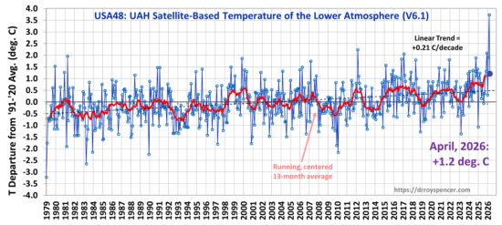
However, April 2026 was an usual month for much of the United States.
Here in Evansville, IN it was our warmest April in history!!
https://www.weather.gov/pah/April2026ClimateSummary
Temperatures averaged well above normal by 7 to 8 degrees. This was the warmest April on record for many locations in our region, including 4 of our 5 climate sites. 80s were a common occurrence with Paducah and Evansville registering 15 such days. An average April typically sees around 4 to 6 days reaching 80. There were only 8 days that finished below normal, the 5th-7th, 18th-20th, and 29th-30th. Temperatures dipped into the 30s several of these nights. There were 6 daily record highs and 24 record warm lows across our 5 climate stations for the month.
The 6 month period from November through April officially finished as the 2nd driest on record in Paducah, Cape Girardeau, and Carbondale. Amounts were generally 8 to 15 inches below normal in this 6 month period.

+++++++++++++++++
The epicenter of the positive temperature anomalies below was on top of Evansville, IN!
https://www.cpc.ncep.noaa.gov/products/tanal/temp_analyses.php

++++++++++++
Interestingly, there were negative temp anomalies along the Canadian border that caused some EXTREME temperature gradients at times between the very warm south and cold north. This was a continuation of the pattern earlier this year that featured record warmth in the southern parts of the US and near record cold in Alaska/Canada with some of the cold spilling south of the border at times. This extreme temperature gradient resulted in an extreme pressure gradient(warm air=light/lower pressures, cold air=heavy/higher pressure and the contrast fueling low pressure storms) and record windy months.
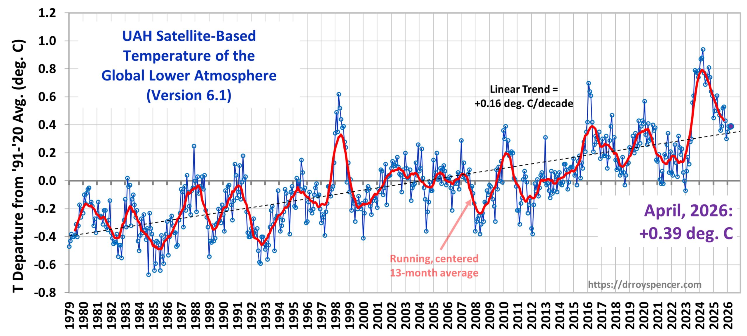
Still no word from Roy Spencers UAH satellite data for April. This is the latest ever for a release, usually it's in within 3 days.
On global temperatures. This Super El Nino will be belching heat from the tropical Pacific into the atmosphere(as all El Nino's do) and very likely increase global temperatures later this year into 2027 ON TOP of the very slow warming being superimposed on the atmosphere by the INDISPUTABLE physics of increasing CO2 from humans burning fossil fuels.
https://www.mercator-ocean.eu/bulletin/ocean-temperature-bulletin-april-2026/
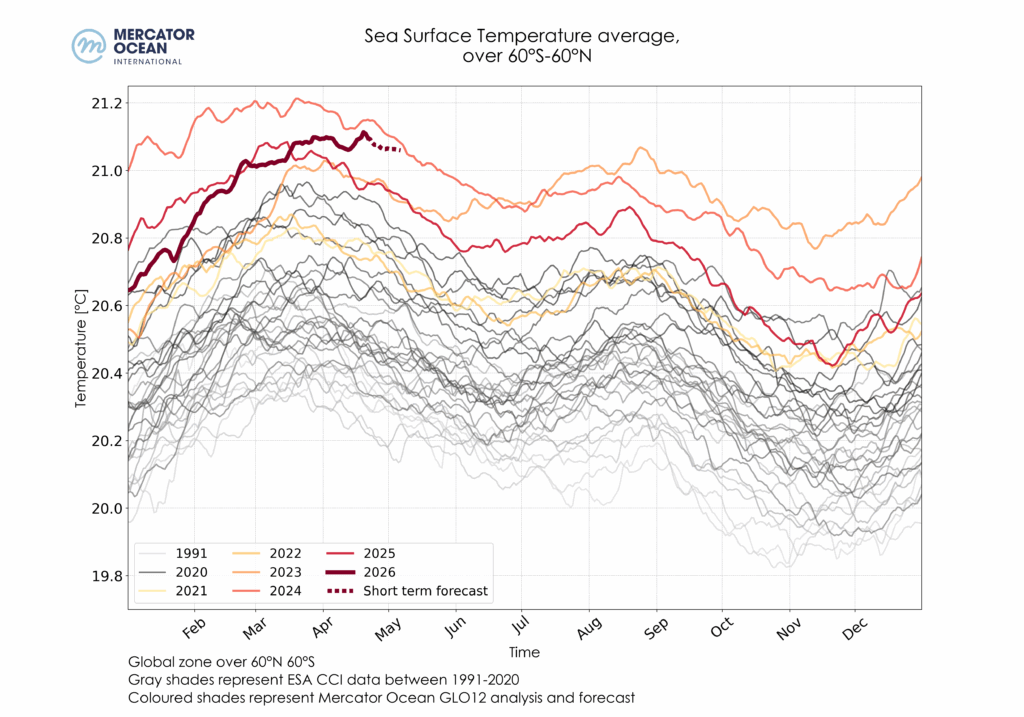
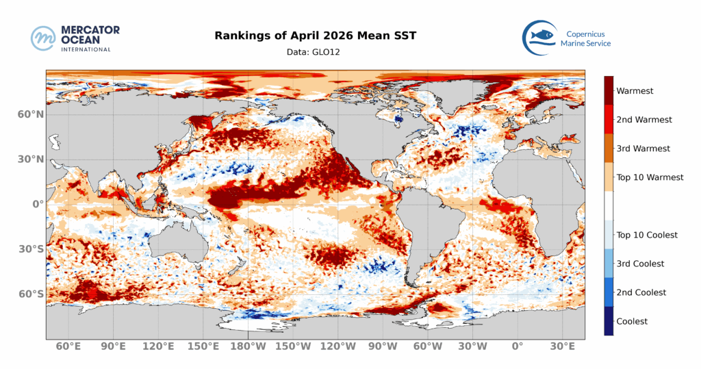
Ranking of average monthly SSTs reached in April 2026, calculated using daily data from Mercator Ocean International’s GLO12 analysis and forecasting system for 2026 and from the GLORYS12 reanalysis for the climatological mean. The colours indicate the rank of April 2026 among all months of April since 1993.
+++++++++++++++++++++++++++
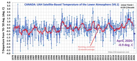
Late in this month but always great data!
May 7th, 2026 by Roy W. Spencer, Ph. D.
https://www.drroyspencer.com/2026/05/uah-v6-1-global-temperature-update-for-april-2026-0-39-deg-c/
1. World
2. United States
3. Canada
++++++++++++++++++++
With the oncoming SUPER DUPER El Nino, global temperatures are extremely likely to make new highs in 2027!
When the Tropical Pacific surface water heats up, it burps out a tremendous amount of heat into the atmosphere. Several of the spikes up in global temperature on the top map were from strong El Nino's. The Super El Nino in 97/98 especially stands out!
There is usually a lag of several months before we see the warming impact from the El Nino show up in the global temperature data, so not until later this year. It would be a huge shocker to not be warmer during the first 6 months in 2027 than the first 6 month of 2026. Something we've never observed before would have to prevent this from happening.
2-17-26 El Nino, here we come-FAST!
Started by metmike - Feb. 17, 2026, 11:54 a.m.
https://www.marketforum.com/forum/topic/117969/