Get all the comprehensive weather here:
https://www.marketforum.com/forum/topic/83844/
++++++++++++++++++++++++
The metrics on this page and other places will be constantly updated below!
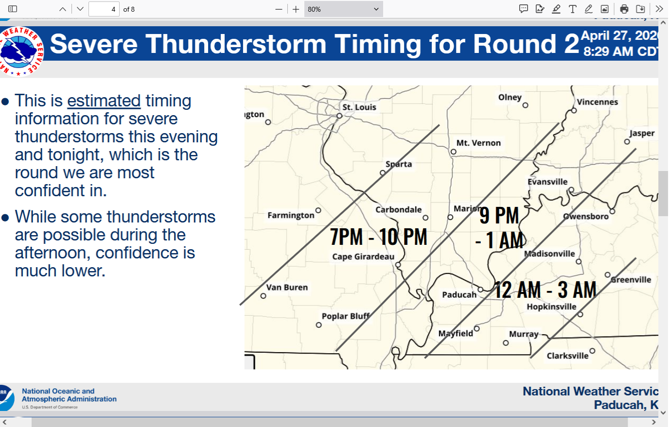
Monday, 4-27 looks like the worst day.
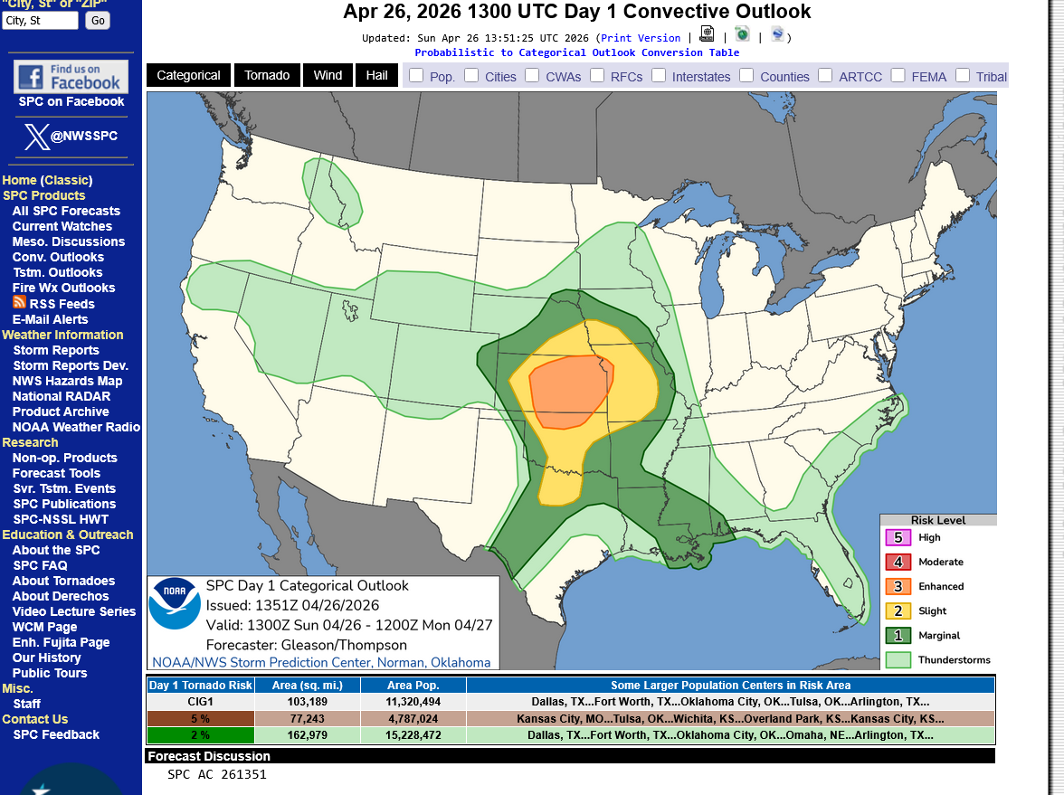
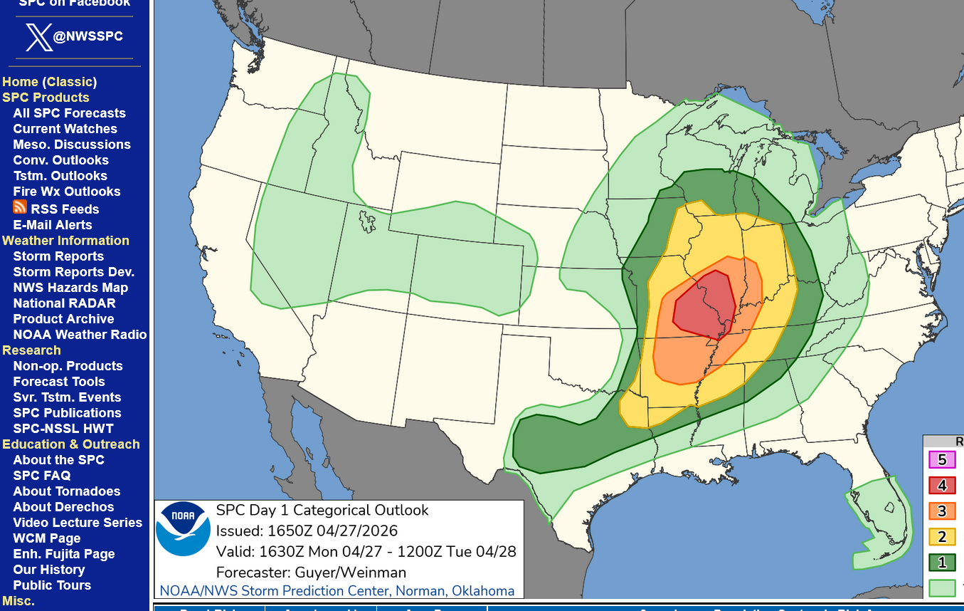
Day 1: Sunday 4-26-26. Categorical.
https://www.spc.noaa.gov/products/outlook/day1otlk.html
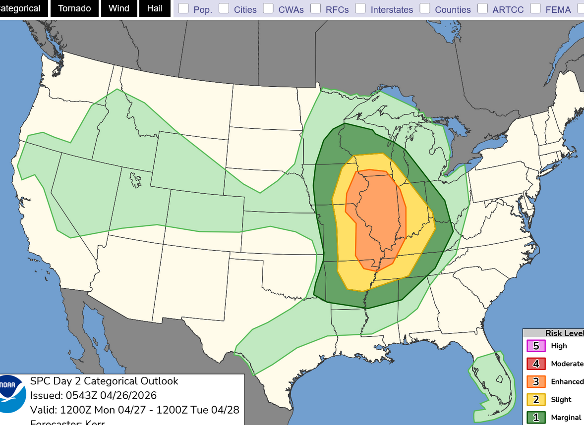
Day 2: Monday 4-27-26. Categorical risk.
https://www.spc.noaa.gov/products/outlook/day2otlk.html
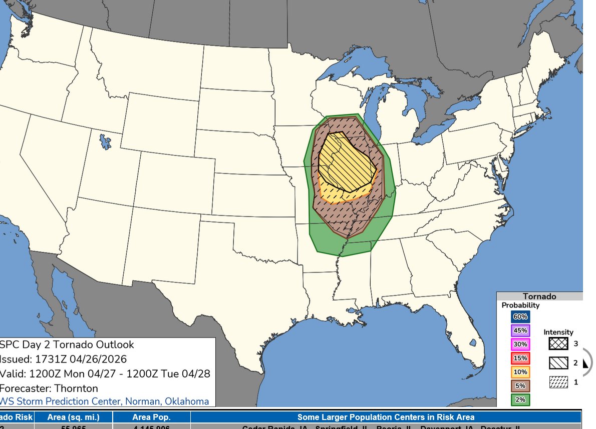
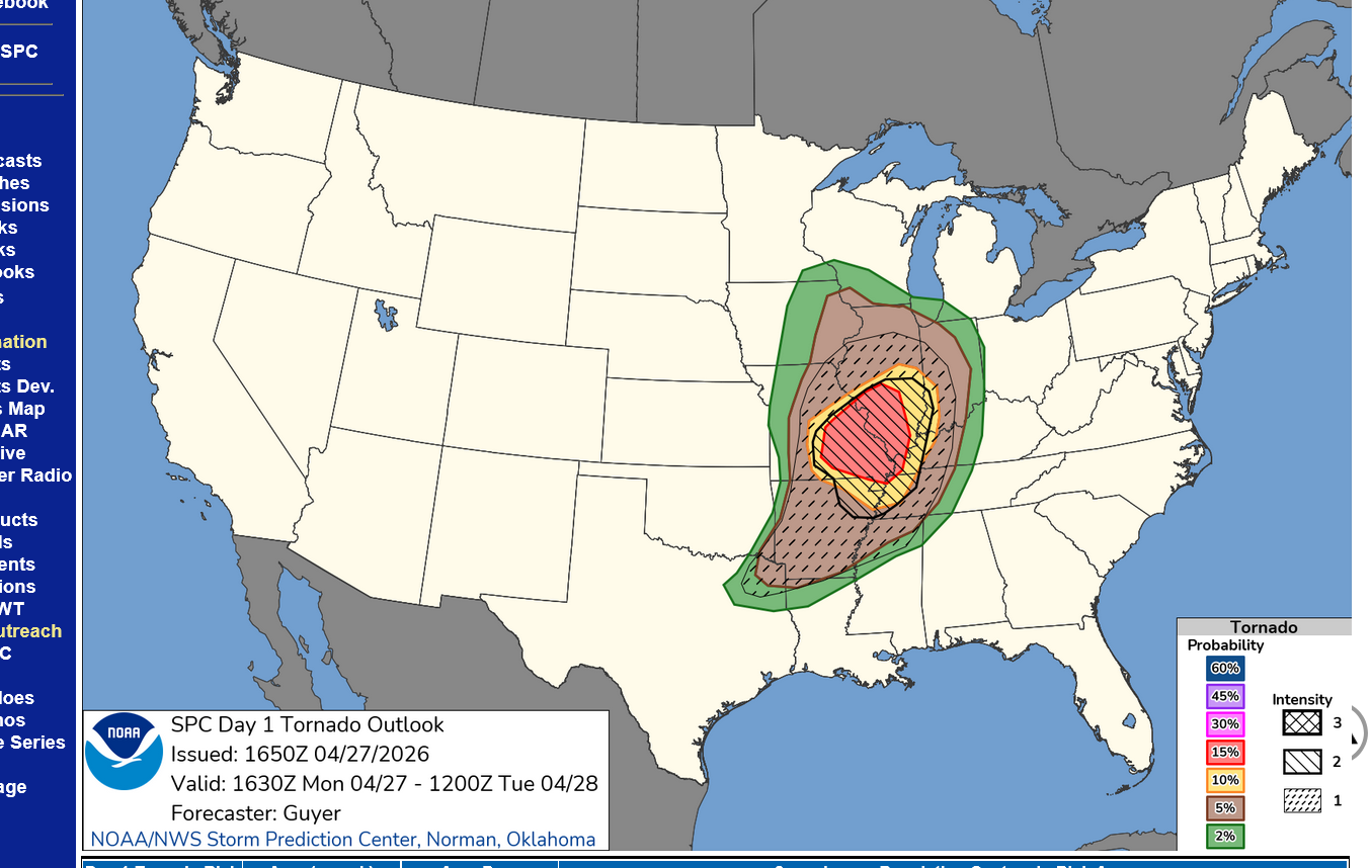
Tornado risk, day 2: Strong tornadoes possible with this event, especially in the yellow shaded areas.
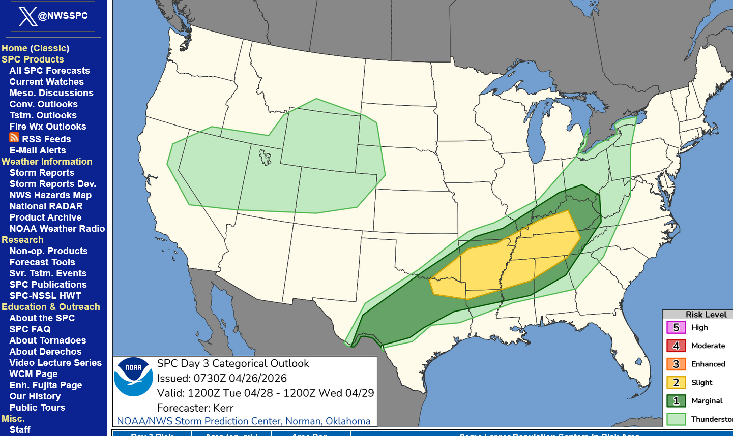
Day 3 categorical risk:
| SEVERE THUNDERSTORM COOKBOOK |
METEOROLOGIST JEFF HABY
https://www.theweatherprediction.com/severe/cookbook/
++++++++++++++
Surface map late Monday, 12z GFS model forecast. Cold front crossing the Mississippi River into IL.
850 mb winds and moisture(5,000 feet=1 mile up) Monday Eve.
Strong, low level inflow/jet stream from the south with warm/humid air.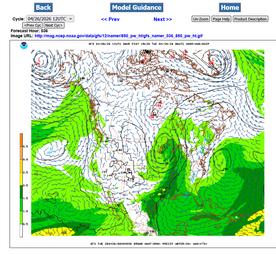
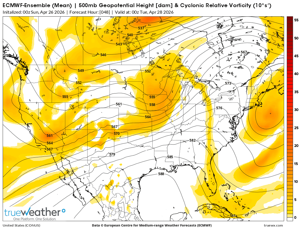
500 mb vorticity late Monday (18,000 feet=3+ miles up)
Strong positive vorticity advection hitting WI/IL/MO at this time. European model.
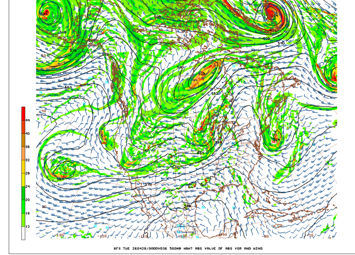
Vorticity from the GEFS model.
250 mb jet stream (32,000 feet=6 miles up). 120+ mph jet streak left front quadrant in IL/IA is especially dangerous because there is added upper level divergence in that quadrant that LIFTS the air below which adds to upward moving air parcels(destabilization).
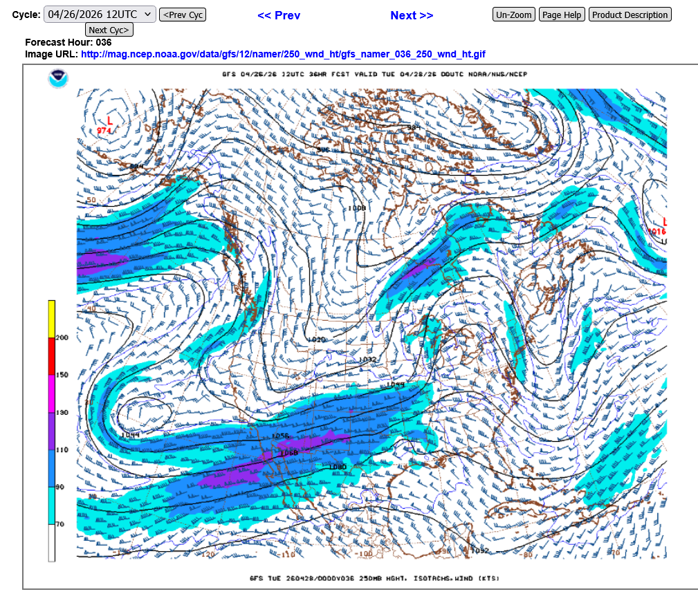
HABYTIME MINI LECTURE 26:
QUADRANTING A JET STREAK
https://www.theweatherprediction.com/habyhints2/601/
+++++++++++++++++
Get all of Jeff's wonderful tutorials here:
| THE ULTIMATE WEATHER EDUCATION WEBSITE |

Current Hazards at the link below.
For your NWS and county, go to the link below.
Then you can hit any spot on the map, including where you live and it will go to that NWS with all the comprehensive local weather information for that/your county.


Current Conditions below updated every few minutes.
https://www.spc.noaa.gov/exper/mesoanalysis/new/viewsector.php?sector=19

https://www.mesonet.org/weather/air-temperature/national-wind-chill-heat-index

https://thermastor.com/dew-point-and-weather-maps/

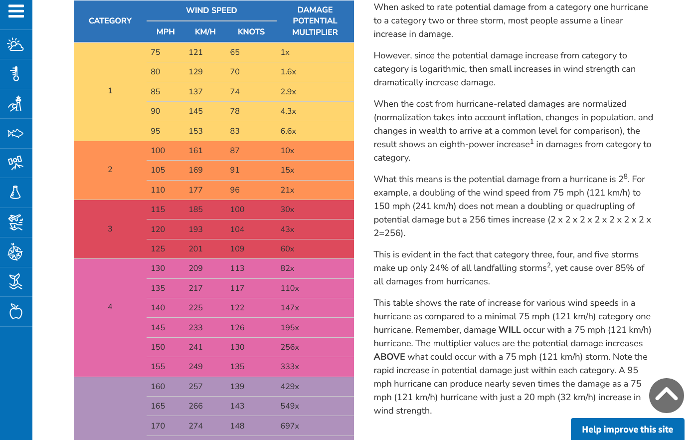
The type of tornado possible today is an EF3. This means 136 mph+.
Enhanced Fuita scale
https://en.wikipedia.org/wiki/Enhanced_Fujita_scale
| EFU | Unknown | No surveyable damage |
|---|---|---|
| EF0 | 65–85 mph | Light damage |
| EF1 | 86–110 mph | Moderate damage |
| EF2 | 111–135 mph | Considerable damage |
| EF3 | 136–165 mph | Severe damage |
| EF4 | 166–200 mph | Devastating damage |
| EF5 | >200 mph | Incredible damage |
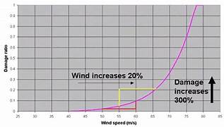
Here's the deal on wind and damage.
As wind increases the damage massively increases on an exponential scale. This applies to ALL wind.
Severe storms, hurricanes and especially tornadoes that have the strongest winds of all, which means the tornadoes with winds over 150 mph have incredible damage.
+++++++++++
+++++++++++++++++++++
A 150 mph wind does 256X more damage than a 75 mph wind. Let's repeat that. A 150 mph wind does 256x more damage than a 75 mph wind!
Hurricane Damage Potential
https://www.noaa.gov/jetstream/tc-potential
++++++++++++
Less than 1% of tornadoes are F4 or F5 but they kill 67% of the people!
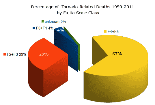
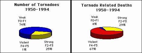
Note that the majority of tornadoes, F0 and F1= 74%(on the old scale) only killed 4% of people and they were probably outside or in a mobile home.
The F4 and F5's were just 1% but caused 67% of deaths.
+++++++++++++++++++
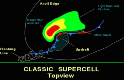
https://www.weather.gov/ama/supercell
++++++++++++
Excellent presentation at this link below that describes the different types of tornadoes and the damage they cause. Keep in mind that the EF4 and EF5 tornadoes are extremely rare. Less than 1% of tornadoes are this strong.
The EF4 and EF5 tornadoes will usually have the HIGH, level 5 risk earlier that day.
Mike Simon Tornado Damage Intensity; Enhanced Fujita Scale
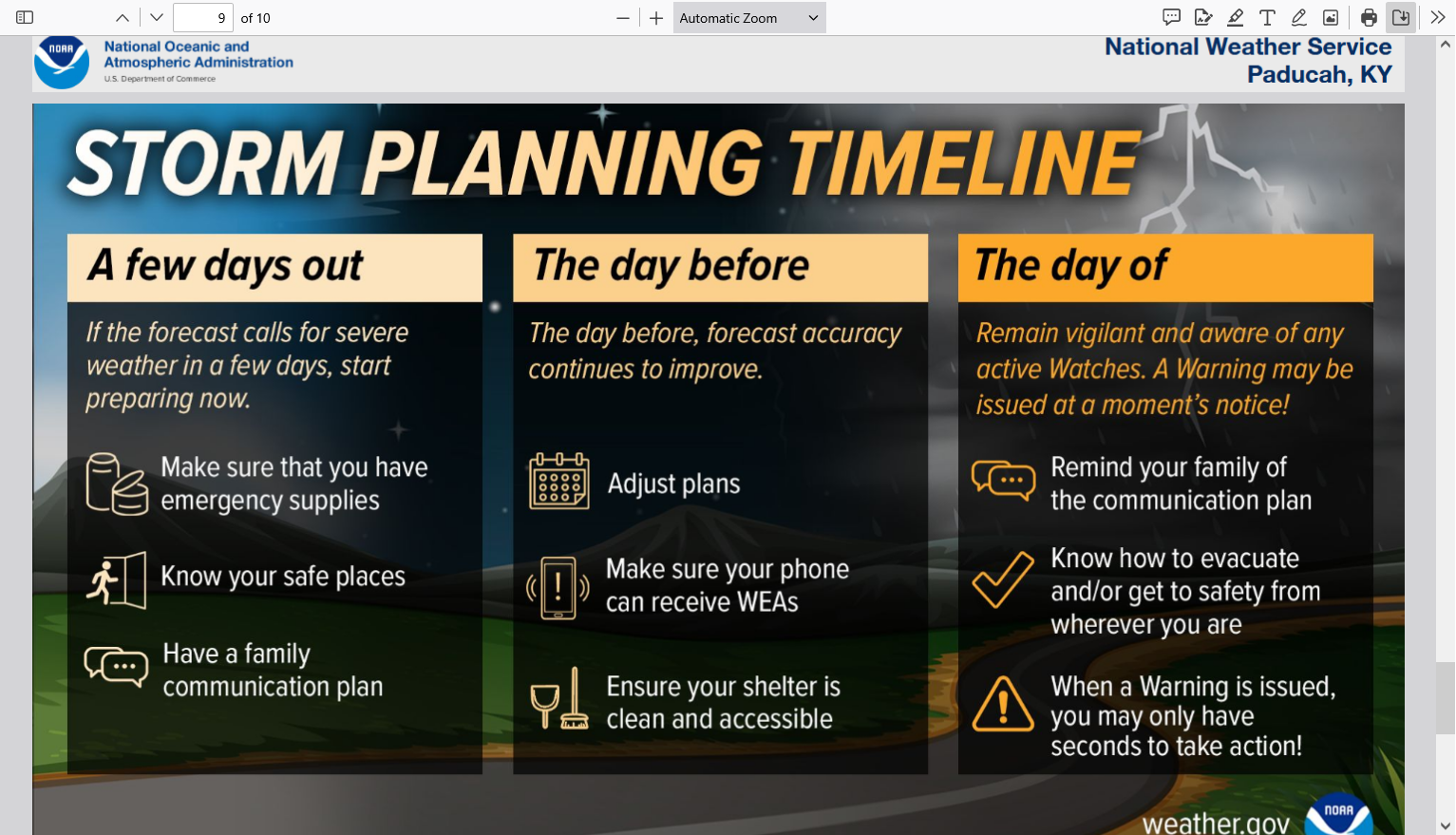
This is the type of threat to go to your safe spot when a tornado warning is issued. Don't be scared..........be prepared! Car accidents kill 1,000 times more people every year than tornadoes. We accept that risk and put on seat belts for safety.
There will be times when we have much higher threats that justify being especially vigilant because those times will include the threat of violent tornadoes EF4 or even EF5 tornadoes(200 mph+) that are rare but kill the most people. That's when being in a safe place really saves lives. An EF3 with winds of 150 mph is possible today. This is elevated and justifies going to your safe place with tornado warnings this evening.
When will those highest risk times be? We will know and identify them WELL BEFORE it happens.
1. When the Storm Prediction Center has at least a moderate, level 4 out of 5 risk. When they have a 5 out of 5 high risk, it's imperative to stay tuned during that type of severe weather outbreak and be ready to act, while still keeping in mind that even during the worst tornado outbreaks, what we are doing is REDUCING the risk of being killed by a tornado from a very small number to a MUCH SMALLER number by taking actions.
2. The Storm Prediction Center will use this verbiage: "This is a particularly dangerous situation".
We know what conditions cause those type of tornadoes with high confidence days in advance but will NEVER be able to predict them with pinpoint accuracy until the storms causing them are in progress,
All tornadoes are absolutely NOT CREATED EQUAL!!!
The total lives lost from 1,000 EF0 tornadoes might not add up to the lives lost from just 1 really bad EF5 tornado!
A 150 mph EF3 wind has 256 times more damaging power than a 75 mph EFO wind!
A 225 mph EF5 wind has 256 X 256 times more damaging power than a 75 mph EFO wind!!!!
65,000 times more damaging power in a strong EF5 tornado compared to an EF0 tornado!!!. That's not a mistake or typo in the math.
That's based on physical laws and tens of thousands of surveys of tornado damage which were used to contruct the Enhanced Fujita tornado scale.
Mike Simon Tornado Damage Intensity; Enhanced Fujita Scale
https://www.youtube.com/watch?v=p-653tSCB68
++++++++++++
Understanding this in 2026 and having the technology to warn people long before the life threatening weather makes it a much, MUCH safer world compared to 100 years ago. People in that age found out about the strong tornadoes or other extreme weather events...............when they were actually getting clobbered by them!
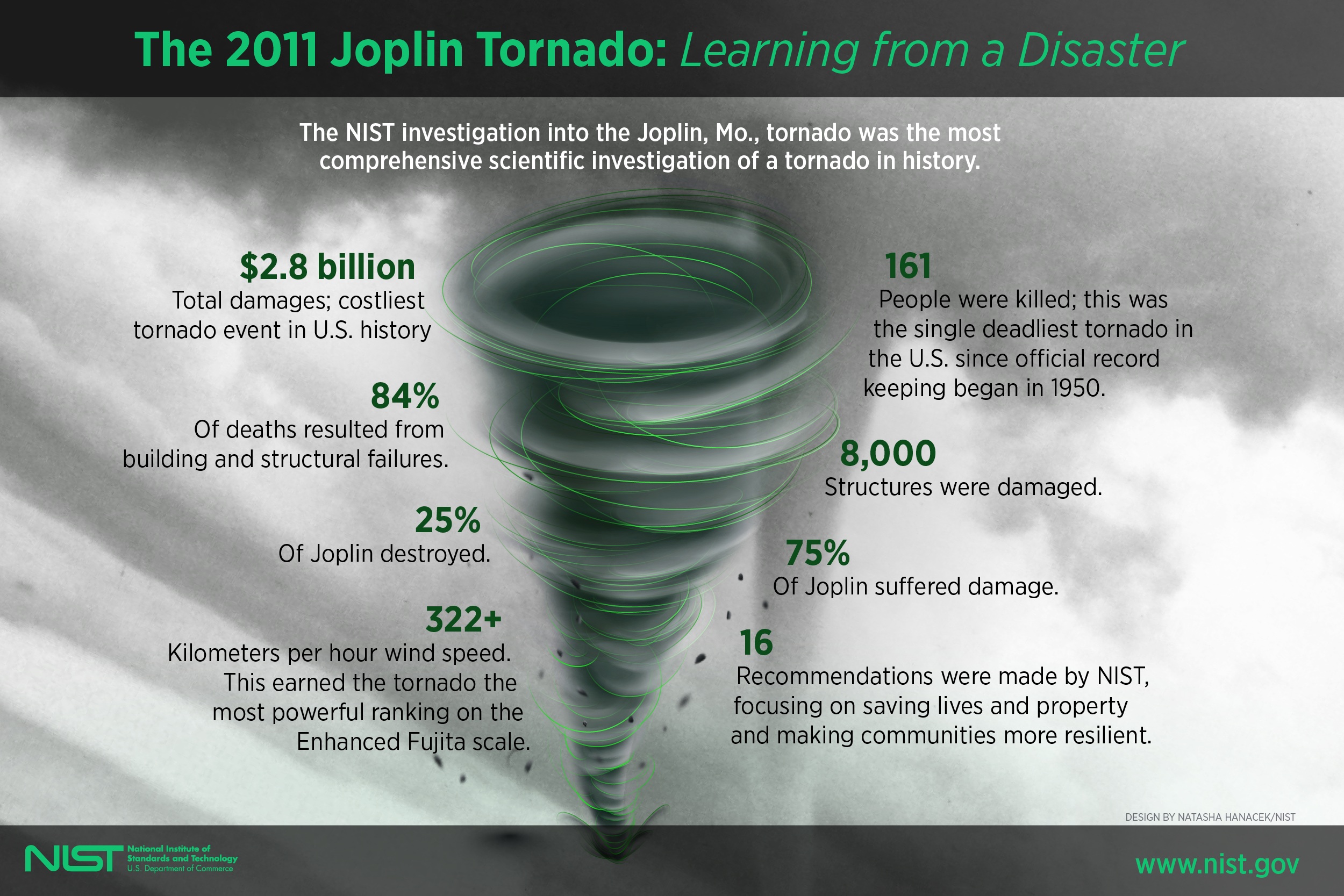
Despite this, there are still limitations based on the worst EF5 tornadoes like the one that struck Joplin, MO in May 2011!
Joplin tornado
https://en.wikipedia.org/wiki/Joplin_tornado
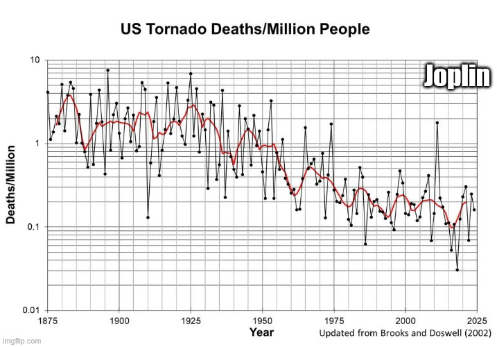
We should note that the scale below is LOGARITHMIC in order to keep the data manageable because of the tremendous drop in values.
The highest numbers on the left top/left that are approaching 10 deaths/million are actually 100+ times greater than the lowest numbers on the right that are LESS THAN .1 deaths/million!
The Joplin tornado in May 2011 caused the huge spike higher and 1 outlying year since the 1970's.
++++++++++++++++++=
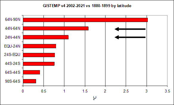
Climate change has been helping too by warming the highest latitudes the most and weakening cold fronts and jet streams! This has reduced the number of the strongest tornadoes by around 50%!
This thread is about TORNADOES not about other impacts from climate change.
May 29th, 2019 by Roy W. Spencer, Ph. D.
Weather becomes LESS extreme in several realms when you reduce the planets temperature contrast with latitude!
4-27-26: An EF5 tornado of 200 mph is NOT likely today because the magnitude of the jet stream, instability and other elements that play a role, while being robust for 150 mph tornadoes, fall short of the extremes we usually see that generate the most deadly tornadoes of all. It's not impossible, just unlikely. Again, don't be scared just be prepared.
Try to avoid being out when the storms will likely hit. If you are in a car, try to avoid travel on roads where a tree can fall on your car.. You are always safe from lightening INSIDE your vehicle. Lighting will pass thru the metal exterior and be grounded thru the tires. Never be outside with lightening, even garden variety thundershowers.
Ideally, be home when a tornado warning is issued. If the storm has a history of tornadoes or has the high potential for EF2+ tornadoes, go to your safe place for a TORNADO warning, until the storm has passed. Lowest level, with as many walls between you and the exterior.
With EF0 and EF1 tornadoes (less than 110 mph) you're good just staying away from windows in a permanent structure. Do NOT stay in mobile homes.
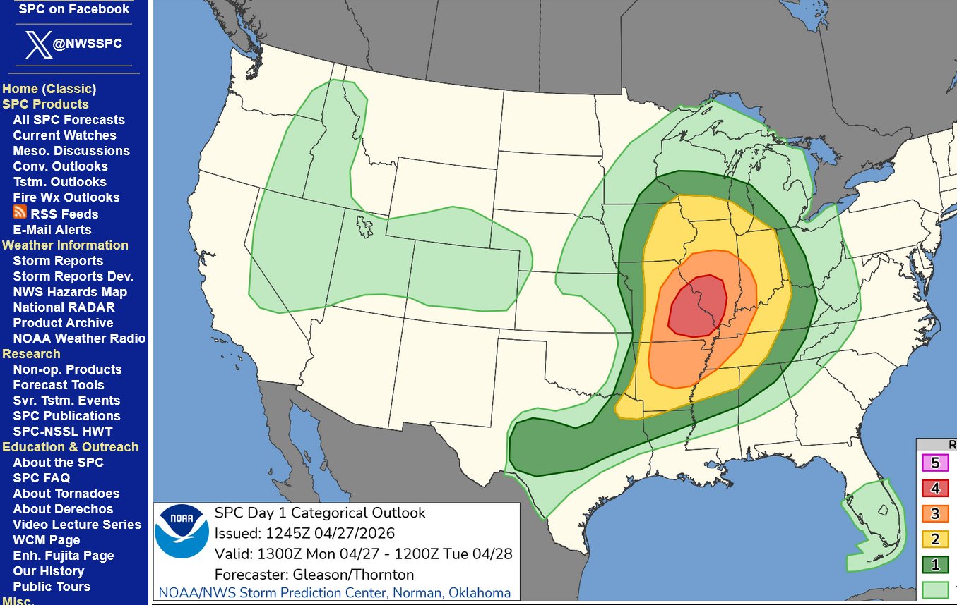
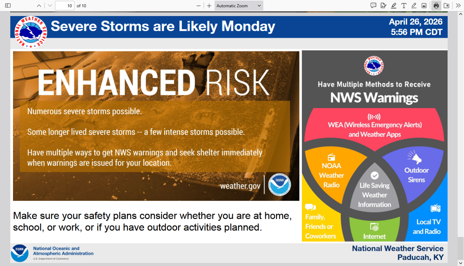
The Storm Prediction Center has, not surprisingly just bumped up their risk to MODERATE, level 4 in the area with the highest threat later today. They will often wait until we get this close to the event to outline the highest risk area with more pinpoint accuracy.
That red shade is over southwest IL/southeast MO. Areas in the surrounding orange, level 3 out of 5 enhanced could also see an EF3 tornado(150 mph). Mother Nature will not be strictly following the map below even though that map captures our wonderful, constantly improving technology used to predict weather with increasing accuracy.
You can read their forecast philosophy at the link below.
https://www.spc.noaa.gov/products/outlook/day1otlk.html
8am I bumped this down to the bottom, for more constant updates. I'm not too worried about these storms coming in this morning. Not likely to have a tornado. Always stay indoors and away from windows in a thunderstorm. You are safe from lightening inside your car too.
++++++++++++++++++
Updated this page at 6:05 am Monday: The risk for strong tornadoes has been adjusted southward early this morning. Highest is now just west of Evansville but we are included in the zone with an elevated risk for a strong, EF-3 type tornado(winds of 136 mph+).
metmike: The highest risk for strong tornadoes is northwest of Evansville, towards central IL but a strong tornado can't be ruled out here.
From our regional NWS office in Paducah, KY.
Significant Severe Storms Possible Monday
https://www.weather.gov/media/pah/DssPacket.pdf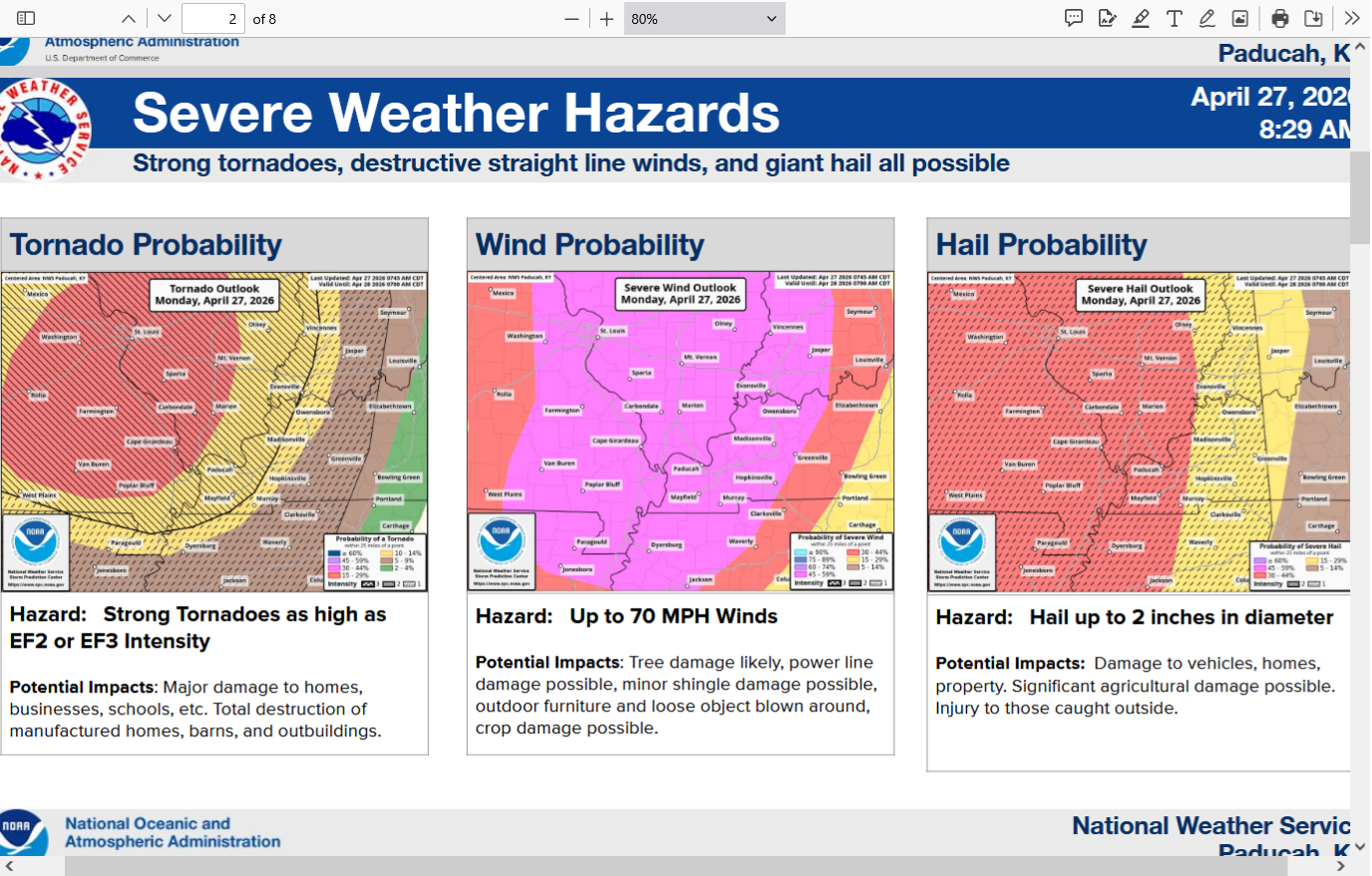

9am: We'll take these wonderful rains and much more!!! The potentially tornadic storms will likely be this evening, although isolated severe storms are possible with this batch.
https://www.cpc.ncep.noaa.gov/products/Soilmst_Monitoring/US/Soilmst/Soilmst.shtml#
![]()
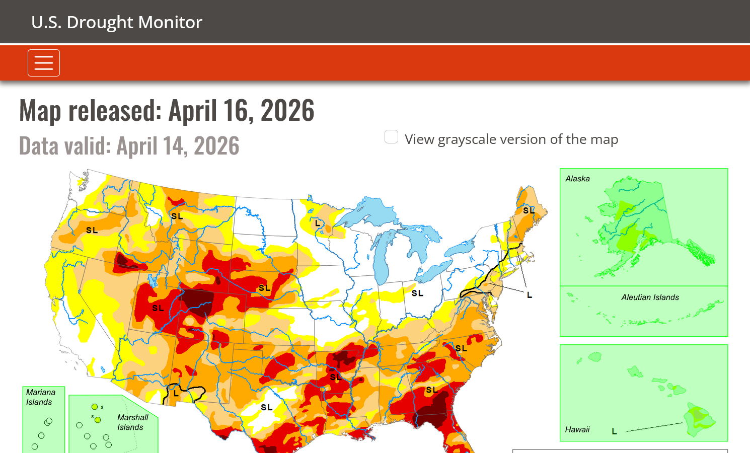
https://droughtmonitor.unl.edu/
Drought gone in the Midwest. Worse in the Plains, South and East.
I took a brief nap but am back.
These severe thunderstorm warnings for counties around us have all been for hail no high winds or tornadoes.
12:45 pm; The first TORNADO Watch of the day has just been issued to our west. That one is until 9pm,with the eastern edge at the Wabash River. That means they figure the big storms could be that far at that time.
These Super Wonderful rains are associated with a warm front that went thru

+++++++++++++
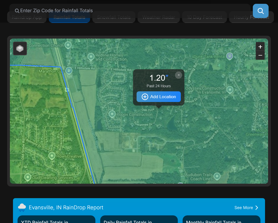
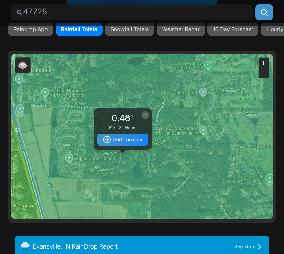
Here's a great link to find out how much rain you got. Just put in your zip code and put your cursor on any location on the map(you can zoom in).
https://www.raindrop.farm/rainfall-totals/zipcode/47725#map
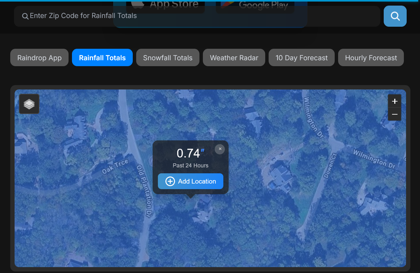
It shows .74 at our house. My rain gauge was around .75!
+++++++++++++
I have a doctors appointment at 3pm but will otherwise be focusing on Evansville's weather until at least late evening/when the threat passes, while still noting tornadic situations outside of our region.
The Storm Prediction Center made their mid-day update in their forecast philosophy and its unchanged but with some strong language about the type of tornadoes possible. EF3+ which would be 150 mph+.
https://www.spc.noaa.gov/products/outlook/day1otlk.html
Categorical:
Tornadoes:
Tornado Watch 160 until 9pm.
EF3+ tornadoes possible. Though thats 150 mph+ and extremely dangerous, they are NOT calling this "a particularly dangerous situation" which is their strongest verbiage.
https://www.spc.noaa.gov/products/watch/ww0160.html
| < Previous WW |
| |||||||||||||
|
If you want to get Storm Prediction Center discussions BEFORE they issue an actual watch, go here:
https://www.spc.noaa.gov/products/md/

Here's the latest. Tornadoes to 170 mph and a watch coming soon to this area. They could expand that to Evansville but, regardless a Tornado watch is coming for us pretty soon, though the potentially bad storms will not happen until this evening:
https://www.spc.noaa.gov/products/md/md0571.html

The time stamps here are in EDT,
We got the tornado watch as expected. I’m at the doctors office and will be back with mor comments by around 4pm. The links above will get you to everywhere you need for information. No threat for numerous hours.
They just came out with this language for our watch “this is a particularly dangerous situation”
That puts the risk into a pretty high level!!!
A 170 mph tornado is the low end of an EF4 tornado! Take this one seriously!
+++++++
1 way to be prepared in case of a power outage is to have your electronics all charged up.
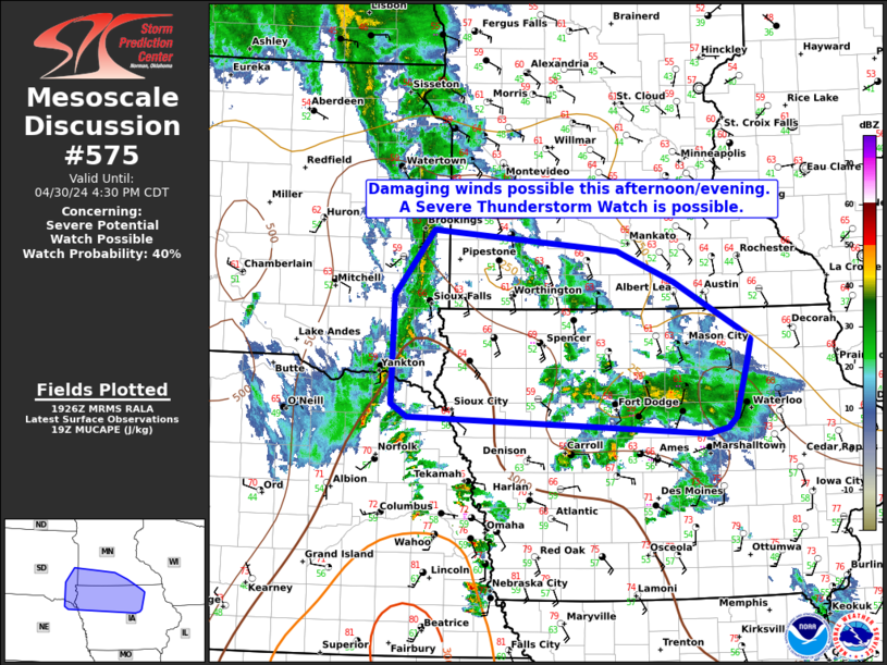
Inside the watch box, the Storm Prediction Center will update us with mesoscale discussions. This one was just issued. They are specifically targeting this area below as the one to potentially see explosive storm development the next couple of hours. We would be directly downstream. They still list an upside of 170 mph tornadoes as possible.
SORRY! The first link below was the older mesoscale discussion!
https://www.spc.noaa.gov/products/md/md0575.html
Instead of being scared...........be prepared and extremely grateful that in 2026, the Storm Prediction Center and other incredible technology's can bring such robust, educational and life saving information to us in such a timely fashion and convenience using our electronics.
4 decades ago as chief meteorologist at WEHT in Evansville, nobody in our field could have ever imagined anything anywhere close to this. Back then, with the old radars and technology, a tornado often had to touch down before a warning was issued. People initially in the path got very little warning!
And that seemed awesome compared to 50 years before then when we had............NOTHING!
Everybody in the path learned about the tornado when they saw it or it was hitting their house!
++++++++++++++
Doing this for so long, I know there are numerous people reading this that are petrified right now.
We should keep in mind that even in most tornado outbreaks, if you go to your safe place when the tornado is hitting your county, you are more likely to die in a car accident this year!
Max Velocity:
This is the one to use:
https://www.youtube.com/live/MkKRk0Ngx_8
Ryan Hall Y'all:
https://rcmediaservices.net/ryan-hall-weather/
This is the one to use:
No tornadoes yet reported today! Lots of hail around mid-day in the Evansville area. The time stamps at the top of our pages here are in EDT!
https://www.spc.noaa.gov/climo/reports/today.html

6:16pm: Watching the storms southwest of Evansville for potential explosive development(according to the Storm Prediction Center):
6:40 pm. Almost NOTHING has happened with those storms! This is different than what the Storm Prediction Center was expecting.................so far!
++++++++++++++++
The Storm Prediction Center remains pretty adamant in their most recent mesoscale discussion for this area:
https://www.spc.noaa.gov/products/md/md0579.html
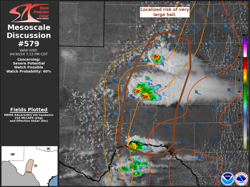
7:22pm: Still almost NOTHING has happened. I hate to disagree with the world's top severe weather authority but this is starting to look like a busted forecast for this particular tornado watch box.
My educated guess is that there is some warm air aloft which is putting a cap/lid on the atmosphere by defeating attempts for lower level, unstable warm/humid, buoyant air parcels to rapidly rise, when they hit the wall of warmth which is even lighter and that causes them to sink, instead of accelerating upward.
However, the actual cold front approaching in a few hours will likely trigger severe weather INDEPENDENT of the dynamics this watch box was issued for.
The added LIFT from the front will cause a different kind of situation that can overcome the cap but the other ingredients will still be in place for tornadoes.
I will guess the type of tornadoes with the cold front could be of a slightly less magnitude but still EF2+.
8:10pm: It's a bust for this tornado watch box! It happens. A vertical temperature profile that is different at 1 level aloft by a couple of degrees can make the difference between an outbreak of strong tornadoes or.........nothing. Nothing is always the preferred scenario.
The current tornado box that was anticipating super-cell storms with potentially EF3+ tornadoes has busted!
Regardless, they'll need to issue a NEW tornado box associated with the approach of the cold front. We'll cover that on the next page.
Below was the Storm Prediction Center's last mesoscale discussion FOR THE COLD FRONT.
This will be our only severe weather event, triggered by this approaching cold front that may not be until close until AFTER 10pm since the storms just went thru St. Louis.
Note the threat of tornadoes up to 145 mph. That's still a strong tornado but this will NOT be a particularly dangerous situation (PDS) watch.
Look for that new tornado watch box within the next hour or 2, well BEFORE the storms get close to the eastern edge of the current tornado watch in IL.
The PDS tornado box that BUSTED doesn't expire until 11pm so they may just wait closer until 11 pm. The line of storms ahead of the cold front could produce a strong tornado but NOT the type to justify a PDS box, in my opinion.
These severe weather experts have access to much more information than me, so I always give their thoughts alot of weight. It's their high paying job!
I do it for fun and sharing/educational to help people.
https://www.spc.noaa.gov/products/md/md0583.html

9pm: Still no tornadoes associated with the cold front either, although there have been numerous tornado warnings and there still is a potential for tornadoes, including a strong one. This line of storms is very likely to have STRONG storms when it comes thru. I'll guess around 11pm. Some could be severe but the high end (PDS) threat from earlier has diminished.
We're bound to have some warnings when this line of storms comes thru. There probably were some tornadoes that they confirm this week with damage surveys but they were all WEAK tornadoes. NO STRONG TORNADOES so far or damage that would suggest one. Weak tornadoes do NOT present the same threat to lives as strong tornadoes.
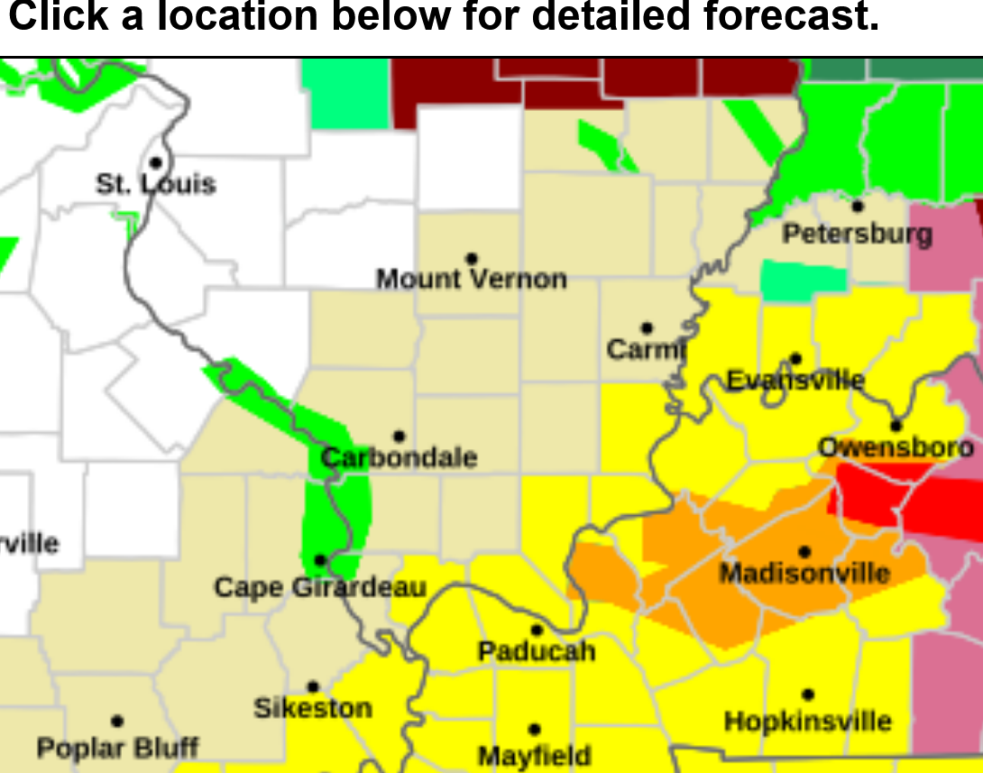
https://www.spc.noaa.gov/products/watch/ww0160_warnings.gif

+++++++++++++++++
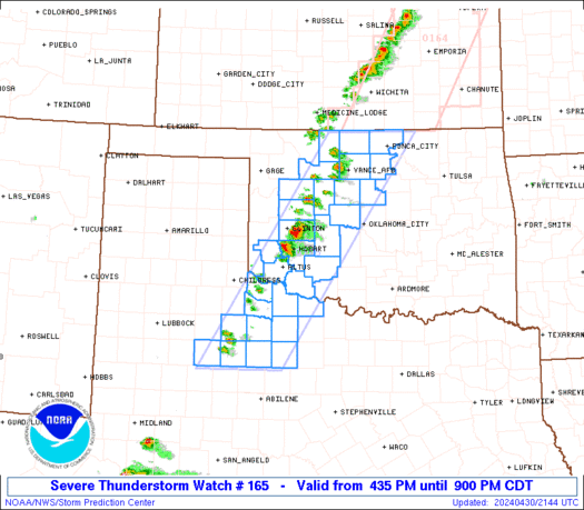
This was the last watch box until 4am and its a severe thunderstorm watch NOT a tornado watch. More evidence that the risk level has dropped off a great deal since they issued the PDS tornado watch that BUSTED completely!
https://www.spc.noaa.gov/products/watch/ww0165.html
Still waiting on the next watch box for us that should have been issued by now.
In fact, the Storm Prediction Center SHOULD HAVE REPLACED the PDS tornado watch box 2 hours ago, when it had obviously busted instead of doubling down on it because PDS watch boxes are very intentionally designed to REALLY get people's attention for a high end threat above a regular threat. We really, REALLY don't want that kind of watch box to have absolutely nothing because its counter productive to the future attention getting messaging objective.
Replacing the PDS watch box with a lesser tornado watch box threat but extending the expiration by 4 hours and extending it much farther east, just south of the current severe thunderstorm watch would have covered their tracks nicely 2 hours ago.
They are still the best but are usually much better than this.
If this is past your regular bedtime, I wouldn't worry too much about going to bed and not staying up in case we have a Tornado warning for a strong tornado.
There have been ZERO strong tornadoes tonight anywhere. It can't be completely ruled out but odds are pretty tiny right now, especially for it to hit YOUR house.
The line of storms is still around 30 minutes away, still think just before 11 pm for Evansville but no strong tornadoes, DESPITE the PDS tornado watch box still in effect.
10:59pm: The leading edge of the storms with some strong gusty winds is thru the north side of Evansville.
11:15 pm: Warning for far southwest Vanderburgh County along the Ohio River, NOT for the rest of V county. Sirens are going off right now. See map below which is a freeze frame.
Even with just a tiny sliver of a county in a warning causes the sirens to go off everywhere in that county,
11:21pm: New warning with a couple of counties in KY now from storms moving away from Evansville.
11: 34 pm: Sirens going off again in V county for a new warning, this time barely clipping far s/southeast V county. 2 warnings for V county in 20 minutes, both along the Ohio River. Freeze frame images above and just below.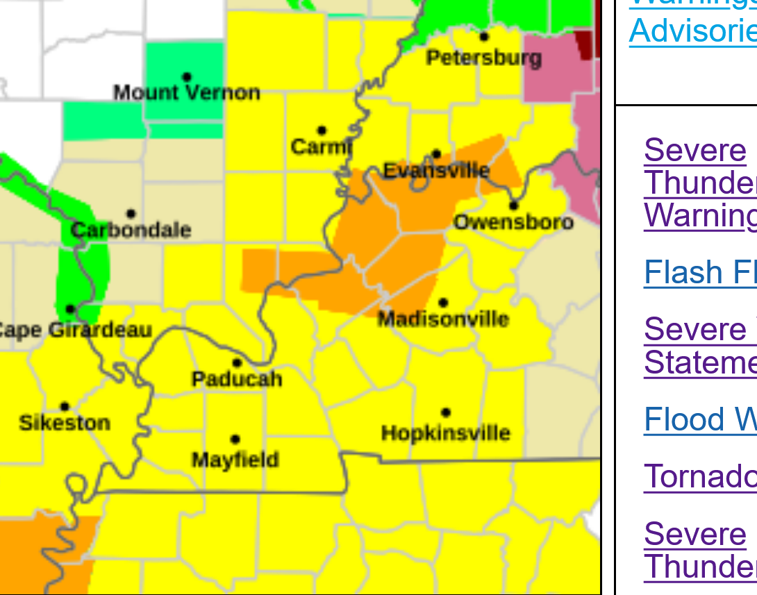
They did issue a new tornado watch box earlier, even though it didn't pop up on their site right away. It's until 5 am but the storm threat is southeast of Evansville and the watch will be cancelled up here in a short while.
https://www.spc.noaa.gov/products/watch/ww0167.html

11:50pm: Several/numerous severe tstorm warnings in KY. 1 tornado warning in red.
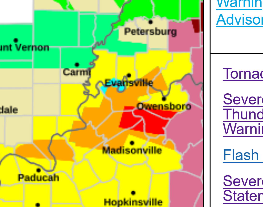
12:12am: Warnings continue southward in KY. Tornado warning in red for a few counties.
This brings our rain total to 1.20 from the 2 events.
.74 around mid-day, then another .46 late this evening.
Every drop welcome to help boost soil moisture that has been depleted from our dry weather this year.
https://www.raindrop.farm/rainfall-totals/zipcode/47725#map
Here are the total severe weather reports from Monday, 4-27-26.
Just 3 WEAK tornadoes. You can read my comments in real time yesterday evening about the Particularly Dangerous Situation Tornado Watch box that remained in effect until it's expiration at 11 pm CDT on Monday.
Re: Re: Re: Re: 4-26/28-26 Severe Storm risk-Evansville
By metmike - April 27, 2026, 7:10 p.m.
https://www.marketforum.com/forum/topic/119816/#119839
+++++++++++
Now for a lesson to learn:
While the Storm Prediction Center has saved many thousands of lives with their timely forecasts and warning of actual deadly tornadoes, yesterday evening was not one of their better performances.
Tornado watch box's that bust have happened before and are part of weather forecasting as somebody who has busted thousands of forecasts in a career spanning 4+ decades knows.
IN this case, the Particularly Dangerous Situation watch box was an especially high stakes SENSATIONAL BUST should have been cleaned up 3 hours before the watch box expired.
This is why. It was crystal clear before 8pm that storms were NOT going to develop ANYWHERE in the watch box after observing radars for 5+ hours in that entire region. This is not Monday morning quarterbacking because I was calling it live last night. The PDS tag on that watch, had a million people inside the watch box still assuming another 3 hours worth of extremely HIGH risk to them that no longer existed.
Instead of canceling the PDS watch and reissuing a NEW watch box without the PDS tag that could have extended well past the 11pm expiration and covered the cold front approaching and displayed objective thinking, INDEPENDENT of the existing PDS watch, they let human cognitive bias interfere with their decision making and allowed the PDS watch to stay in effect an extra 3 hours, with many thousands of people staying up late based on the assumptions and high risks stated in the PDS watch.
We see this all the time in commodities trading and other realms where the principle of "cut your losses ASAP" rules and "don't get married to a position" or like I say: "the most important decision in a trade and elsewhere is often not the entry point but the exit point" In other words, what you did last.
We all make mistakes and weather forecasters using the best information available, make the best forecasts they can based on that but busting(wrong) forecasts are part of the business. Even the best meteorologists bust weather forecasts ALL THE TIME. However, it's not how bad the busted forecast was initially that matters most. It's how quickly the meteorologist RECOGNIZES THIS AND CHANGES IT TO BEING RIGHT that matters the most.
The Storm Prediction Center had an opportunity to choose being right from 8-11pm on Monday Night but instead, like the trader that holds on to a losing position and never cuts their losses early because of cognitive bias, they maximized the loss/bust!
Sometimes, they best way to view this is to ask yourself "if I didn't already have this position previously and was faced with NEW FACTS/EVIDENCE would I put that position on right here and right now?
By 7pm last night, the SPC must have been surprised to see NOTHING developing. If there was no PDS watch in effect, no way would they have issued a new one. By 8pm it was an obvious bust but the watch had been issued 5 hours earlier and they just decided to ride their losses for another 3 hours to make it an 8+ hour busted forecast instead of a 5 hour busted forecast, with the last 3 hours counting the most and defining what they did last, which was to FIX the forecast and STOP the losses.
What were the losses?
At least 10s of thousands of people stayed up an extra couple of hours because the SPC told them they should monitor for life threatening strong tornadoes until 11pm. Countless others who are afraid of tornadoes were needlessly scared for an extra 3 hours. Everybody went thru a big bust that was maximized, which makes the next PDS tornado watch box less meaningful from the "Boy that cried wolf" syndrome.
We already live in an age where over sensationalizing, over kill, over load and over the top embellishing or worse from excessive information makes it tough for people to properly gauge what is most important and even what is real and what is not. This was an opportunity to apply the scientific method( continually fact checking oneself), along with accountability/objective thinking to reduce that.
https://www.marketforum.com/forum/topic/119816/#119839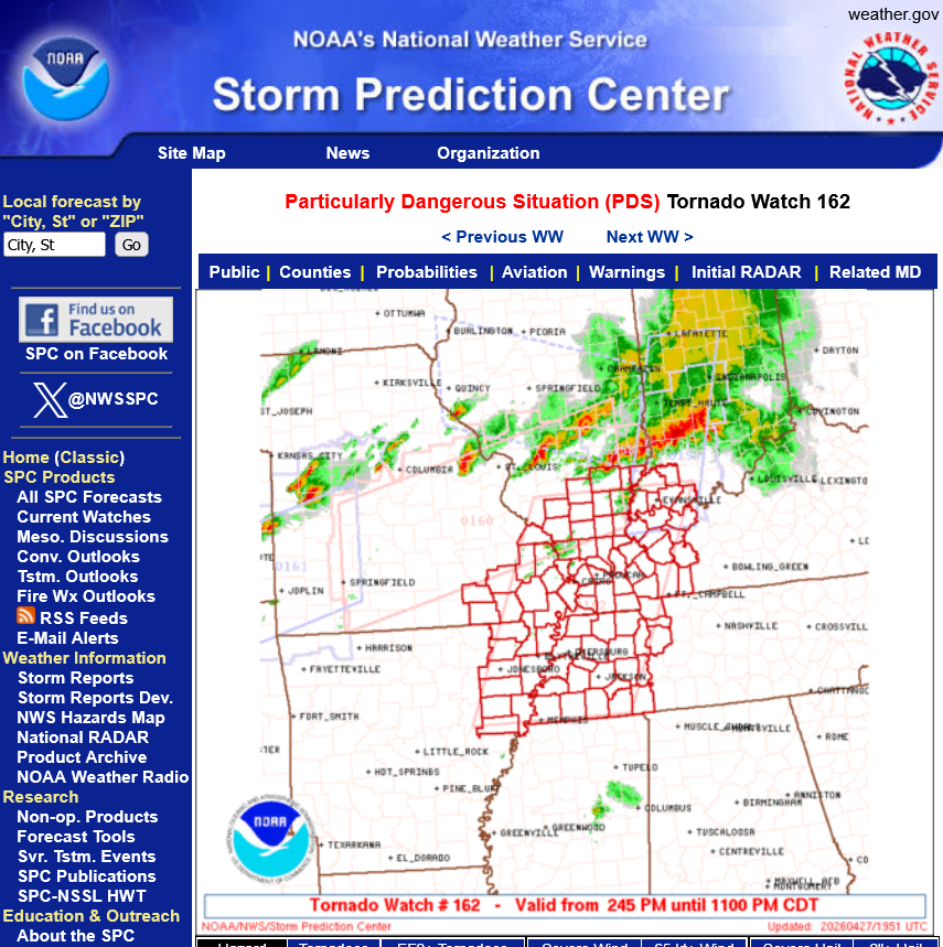
https://www.spc.noaa.gov/climo/reports/260427_rpts.html

We got another .48" overnight, so close to 1.7" total from this event!!!
Just put your zip code into the link below.
https://www.raindrop.farm/rainfall-totals/zipcode/47725#map
Two Tornadoes Confirmed in Western Kentucky from the April 27-28, 2026, Severe Weather Event
1. These were 2 weak tornadoes with winds under 100mph.
2. People inside their homes (not mobile homes) are almost NEVER killed by tornadoes like this. You stay inside, away from windows just like with a severe thunderstorm and will be ok.
3. The trigger for these tornadoes was the COLD FRONT's lift as we got close to midnight.
4. The environment that prompted the Particularly Dangerous Situation Tornado Watch from 2:30p-11pm was mostly INDEPENDENT of the actual cold front. That watch box had already expired when these weak tornadoes happened. Those 2 tornadoes happened under the new, less threatening tornado watch box that was in effect until 4am.
5. I'm going to repeat my previous message about this because nobody else will ever say it.
Because of my profession, I know or currently have known many dozens of people that have an extreme phobia of severe storms, mainly tornadoes. Not just a respect for what they can do that is exaggerated in magnitude but the type of phobia that can be psychologically crippling during regular tornado watch boxes and during a PDS tornado watch box, I think about them in a way that people at the Storm Prediction Center likely do not.
Let me repeat. The PDS Tornado Watch had clearly busted 3 hours before it was to expire at 11pm. The right thing to do then, would have been to reissue a NON PDS Tornado Watch Box FOR THE COLD FRONT that was approaching that noted the less dangerous tag but still mentioning the potential for a strong tornadoes!!!!
I get why the PDS Tornado Watch box busted and don't at all question their very justified reason to issue it. Under similar circumstances in the future, we might very well see a deadly tornado outbreak because of a tiny difference in the upper levels that we can't predict with pinpoint accuracy. It was a good time to issue that PDS Watch Box.
However, they subjected the million people in the busted PDS Watch Box to 3 hours of bad, not updated information because of some sort of scientific, cognitive bias justification that trumped the understanding of the mindsets of those 1 million people in the PDS watch box. The same people that are committed to serving, saving 10s of thousands of lives since they first started in 1952 as the Severe Local Storms Unit (SELS) within the U.S. Weather Bureau in Washington, D.C.
Please don't get this message wrong. I am knocking people that are elevated to a special level in my world. I respect them more than any others and still do.
An elite, accomplished service of the most talented meteorologists on the planet with the best empirical data and wonderful timely, comprehensive information, discussions, watches and warnings.
They are not perfect and I don't expect that. However, they messed up on Monday Night and a million people will only remember the completely busted forecast without understanding that it was justified initially. As mentioned earlier, they blew the opportunity to CANCEL IT EARLY and do what everybody should always do, whether it's in a losing commodities trade or in something in your lives that is causing unnecessary damage that you can STOP IMMEDIATELY by cutting your losses. We are best judged by what we did LAST, especially if it fixes a mistake. Not recognizing the mistake and letting the losses grow only makes it worse.
The SPC turned a 5 hour loss into an 8 hour loss, when they could have changed the last 3 hours(that didn't keep people staying up late for the PDS) to send a much better message to people on the receiving end..........who would have been more forgiving than leaving the highest threat level to lives watch in effect for 3 unjustified hours and many people afraid to go to bed.
In 4+ decades of providing nothing but hundreds of high end compliments for the Storm Prediction Center(which will continue) this is a first for me.
However, people deserve the truth based on the observations of an insider. Whether its bad or good.
The best thing is that we did NOT have any life threatening violent tornadoes, despite the initial conditions JUSTIFYING the PDS Tornado Watch Box.