Get all the comprehensive weather here:
https://www.marketforum.com/forum/topic/83844/
++++++++++++++++
Previous thread:
3-10/11-26 Severe weather
Started by metmike - March 10, 2026, 2:43 p.m.
https://www.marketforum.com/forum/topic/118547/
+++++++++++++++++
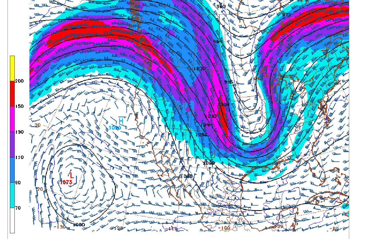
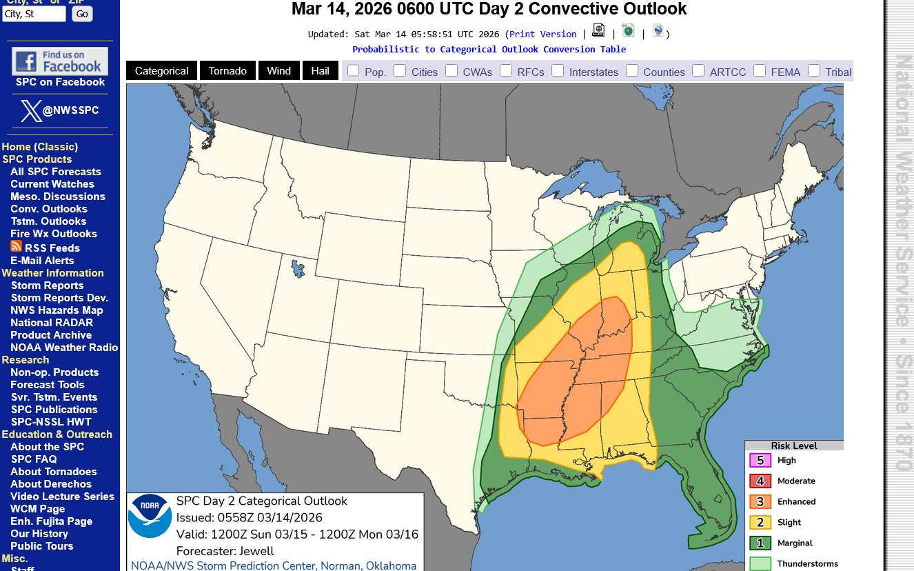
This will be an extremely rapidly developing system/threat.
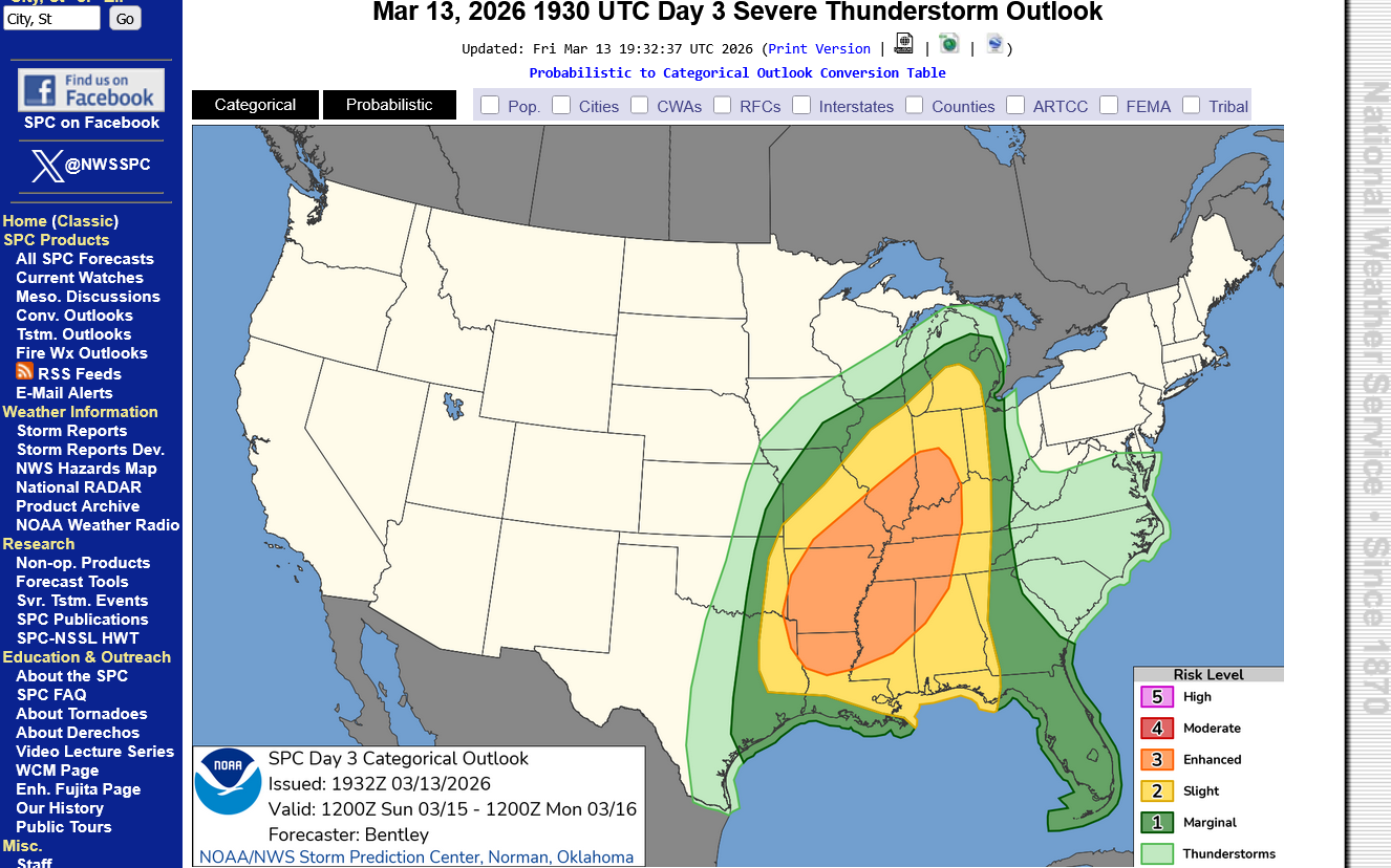
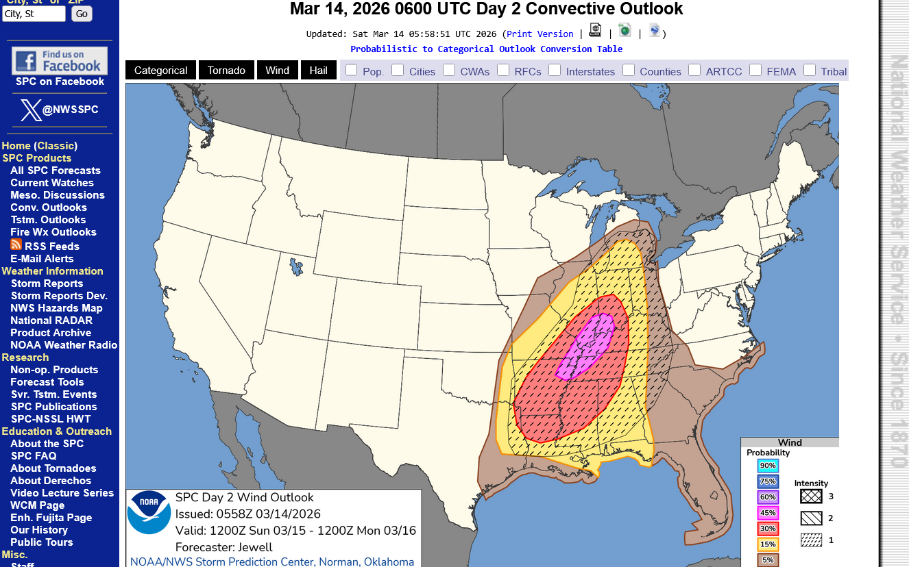
Going from almost NO risk anywhere on Saturday to a LARGE area of at least level 3(enhanced) out 5 risk on Sunday. Probably getting elevated to a level 4(moderate) this weekend.
Stay tuned. There are some unusual dynamics with this one. We have risks similar to this several times/year but this one has some VERY unusual dynamics that have introduced more uncertainty than usual and will probably cause surprises and updates.
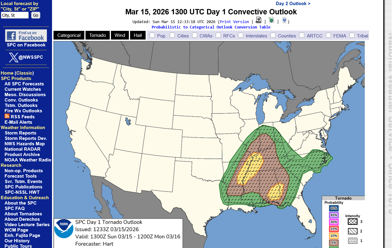
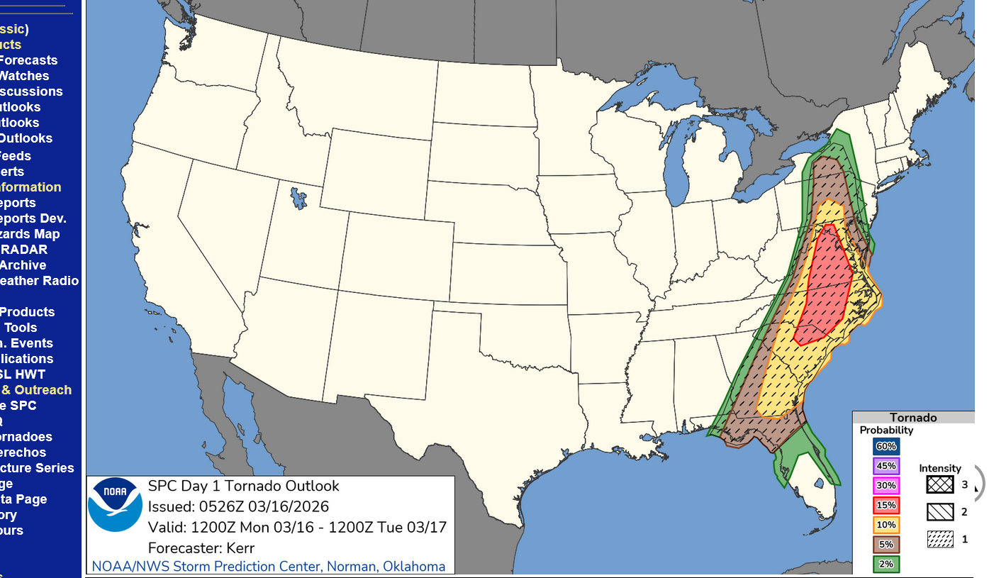
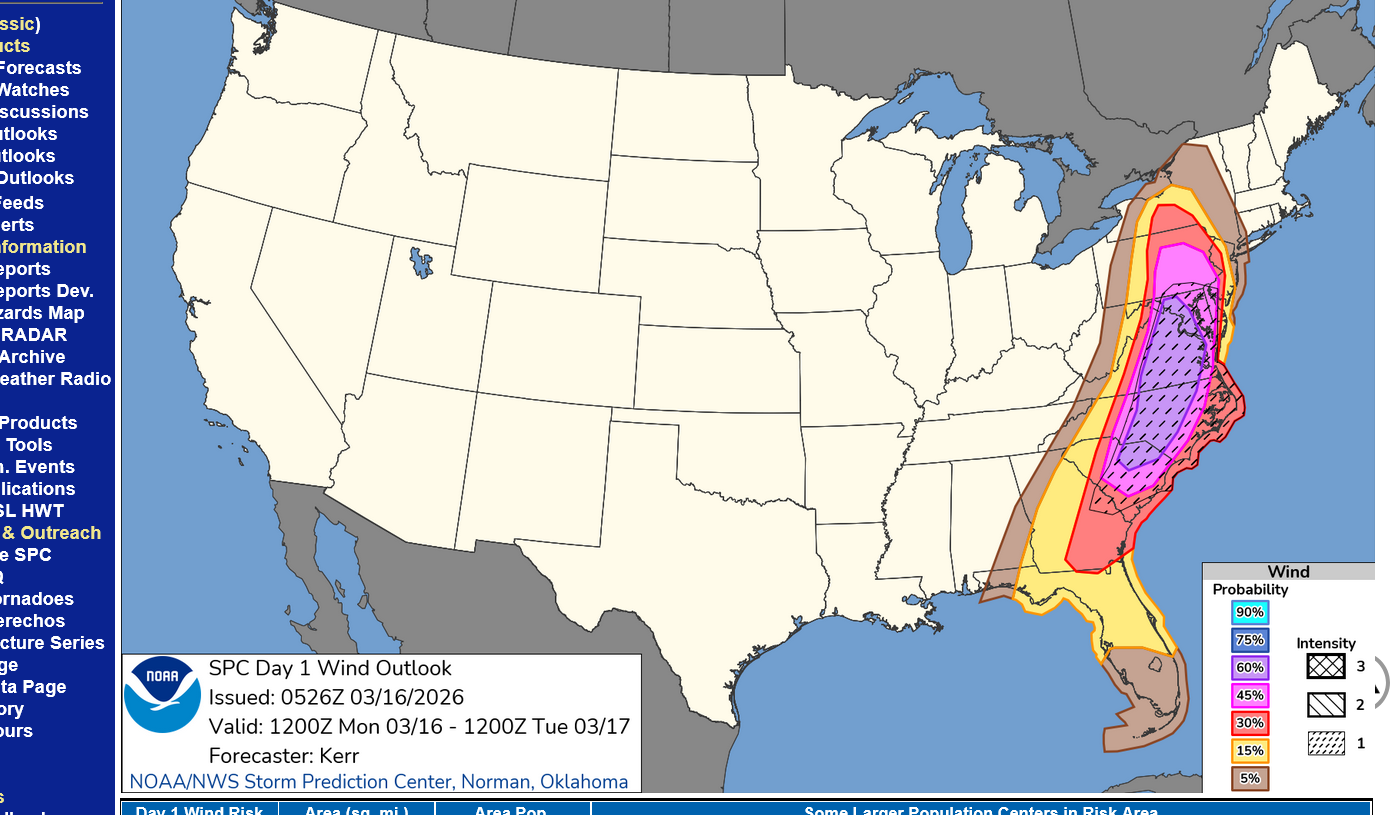
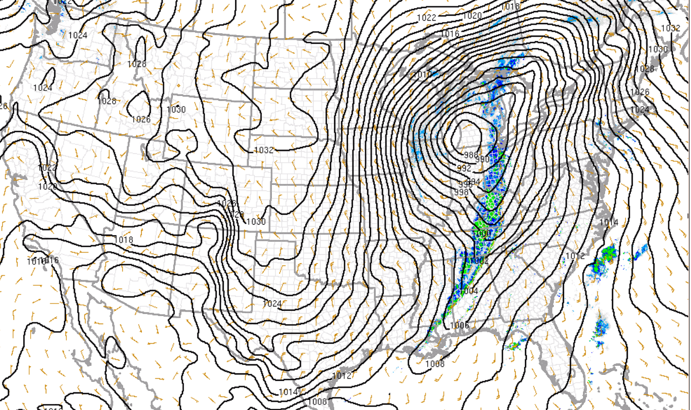
This is for Sunday and Sunday Night below which is day 3 right now. Enhanced in the center is level 3 out of 5. Tomorrow, the day 2 outlook could feature MODERATE level 4 of 5.
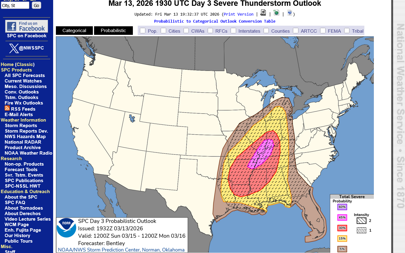
The 2nd map is the actual probability which is 45%+ for severe weather. Within 25 miles of any point. The type of thunderstorms that we could have are capable of 75+ mph winds vs the usual 58+ mph winds.
There could be some strong tornadoes, EF2+ with winds of 150+ mph.
https://www.spc.noaa.gov/products/outlook/day3otlk.html
https://www.weather.gov/media/ewx/iwt/SPC_WPC_Differences.pdf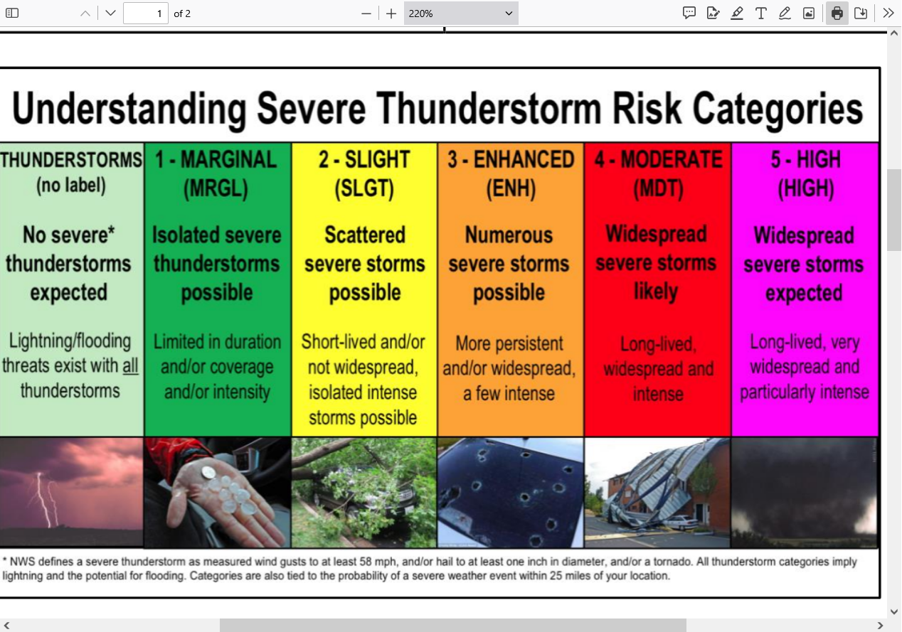
+++++++++++++++++
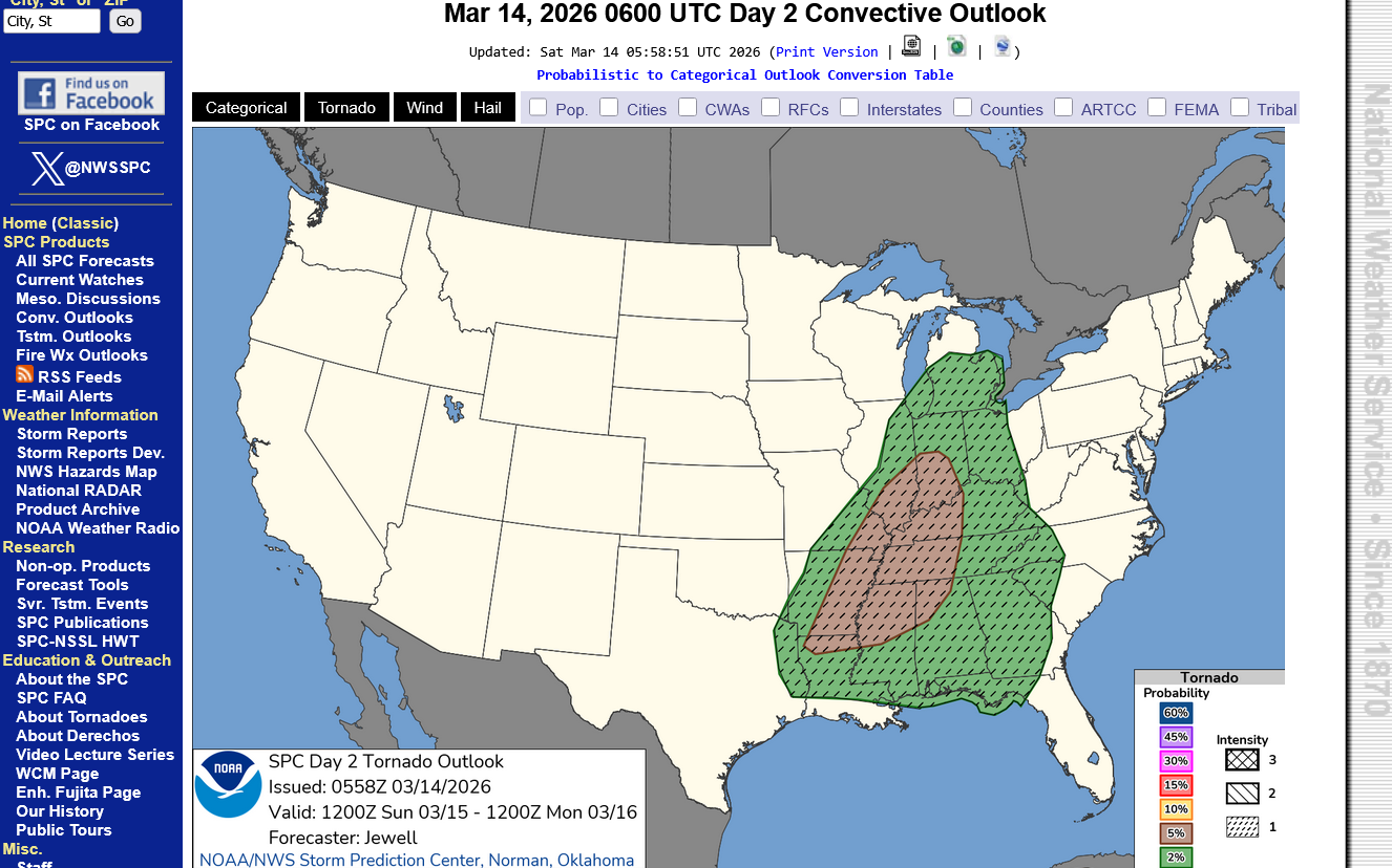
The type of tornado possible in the moderate risk zone is an EF3+. This means 165 mph+.
Enhanced Fuita scale
https://en.wikipedia.org/wiki/Enhanced_Fujita_scale
| EFU | Unknown | No surveyable damage |
|---|---|---|
| EF0 | 65–85 mph | Light damage |
| EF1 | 86–110 mph | Moderate damage |
| EF2 | 111–135 mph | Considerable damage |
| EF3 | 136–165 mph | Severe damage |
| EF4 | 166–200 mph | Devastating damage |
| EF5 | >200 mph | Incredible damage |
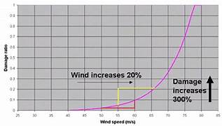
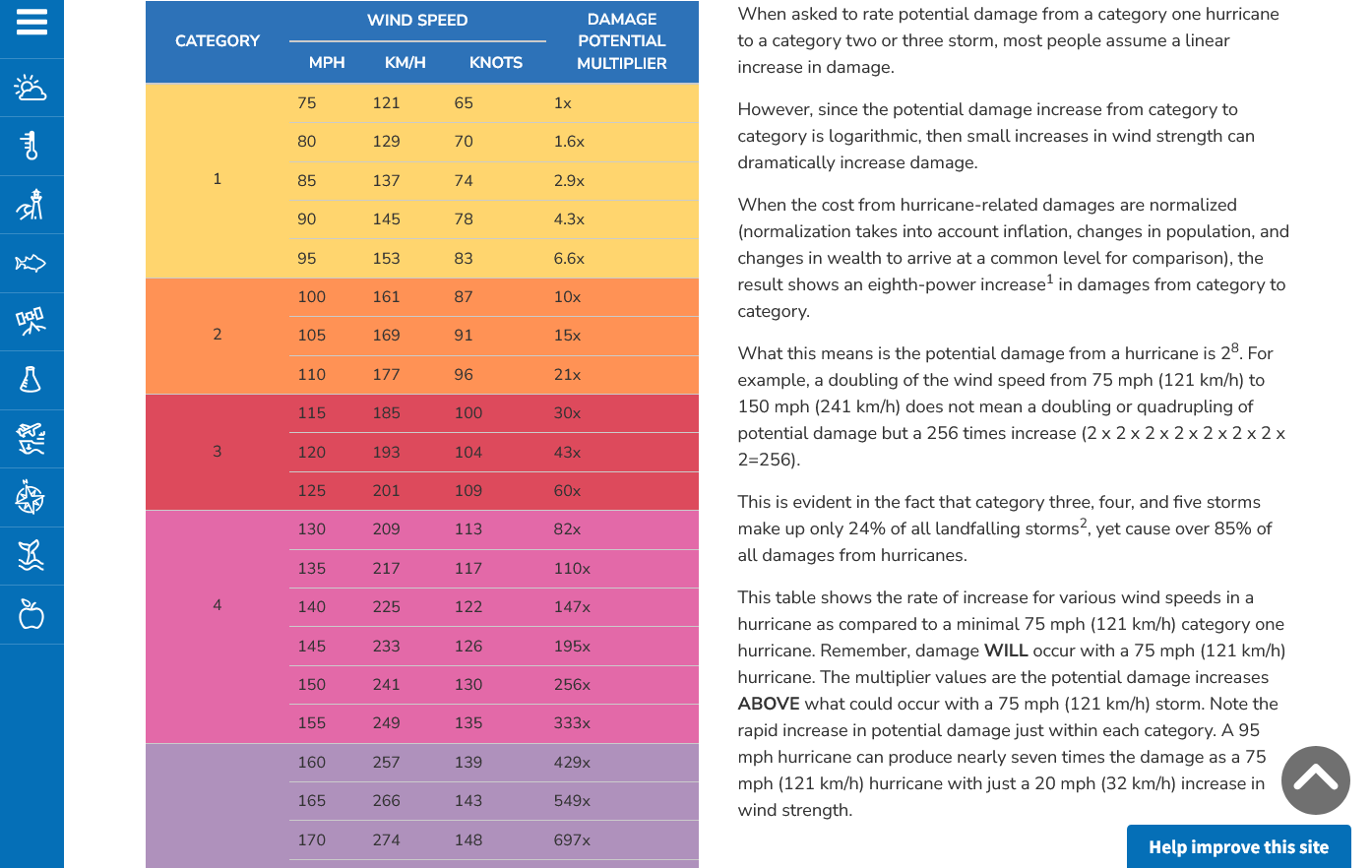
Here's the deal on wind and damage.
As wind increases the damage massively increases on an exponential scale. This applies to ALL wind.
Severe storms, hurricanes and especially tornadoes that have the strongest winds of all, which means the tornadoes with winds over 150 mph have incredible damage.
+++++++++++
+++++++++++++++++++++
A 150 mph wind does 256X more damage than a 75 mph wind. Let's repeat that. A 150 mph wind does 256x more damage than a 75 mph wind!
Hurricane Damage Potential
https://www.noaa.gov/jetstream/tc-potential
++++++++++++
Less than 1% of tornadoes are F4 or F5 but they kill 67% of the people!
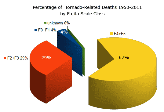
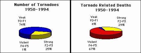
Note that the majority of tornadoes, F0 and F1= 74%(on the old scale) only killed 4% of people and they were probably outside or in a mobile home.
The F4 and F5's were just 1% but caused 67% of deaths.
+++++++++++++++++++
https://www.weather.gov/ama/supercell
++++++++++++
Excellent presentation at this link below that describes the different types of tornadoes and the damage they cause. Keep in mind that the EF4 and EF5 tornadoes are extremely rare. Less than 1% of tornadoes are this strong.
The EF4 and EF5 tornadoes will usually have the HIGH, level 5 risk earlier that day.
Mike Simon Tornado Damage Intensity; Enhanced Fujita Scale
https://www.youtube.com/watch?v=p-653tSCB68
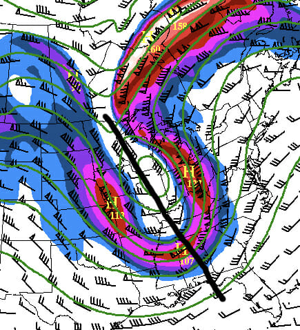
The upper level jet stream (above 30,000 feet) will be pretty strong with close to a150 mph jet streak in our area. It's been stronger before for our most violent tornado outbreaks but this is decent.
Of major note is the NEGATIVE TILT to this anomalous trough. Negatively tilted,upper level troughs cause unique dynamics, explained below that enhance severe weather risks.
https://aerocrewnews.com/2019/03/01/why-is-your-trough-negatively-tilted/
The most incredible thing related to this system is the temperature contrast on either side. On the warm side Sunday, temperatures in Evansville, IN will top 70 degrees with southerly winds gusting above 40 mph.
On Monday, the temperature will be 40 degrees colder and the northwest winds gusting to 30 mph will make it feel 60 degrees colder!!!
However, there will be times this Spring when we DO have much higher threats that justify being especially vigilant because those times will include the threat of strong/violent tornadoes that are rare but kill the most people. That's when being in a safe place saves lives.
When will those highest risk times be? We will know and identify them WELL BEFORE it happens.
1. When the Storm Prediction Center has at least a moderate, level 4 out of 5 risk. When they have a 5 out of 5 high risk, it's imperative to stay tuned during that type of severe weather outbreak and be ready to act, while still keeping in mind that even during the worst tornado outbreaks, what we are doing is REDUCING the risk of being killed by a tornado from a very small number to a MUCH SMALLER number by taking actions.
2. The Storm Prediction Center will use this verbiage: "This is a particularly dangerous situation".
We know what conditions cause those type of tornadoes with high confidence days in advance but will NEVER be able to predict them with pinpoint accuracy until the storms causing them are in progress,
All tornadoes are absolutely NOT CREATED EQUAL!!!
The total lives lost from 1,000 EF0 tornadoes might not add up to the lives lost from just 1 really bad EF5 tornado!
A 150 mph EF3 wind has 256 times more damaging power than a 75 mph EFO wind!
A 225 mph EF5 wind has 256 X 256 times more damaging power than a 75 mph EFO wind!!!!
65,000 times more damaging power in a strong EF5 tornado compared to an EF0 tornado!!!. That's not a mistake or typo in the math.
That's based on physical laws and tens of thousands of surveys of tornado damage which were used to contruct the Enhanced Fujita tornado scale.
Mike Simon Tornado Damage Intensity; Enhanced Fujita Scale
https://www.youtube.com/watch?v=p-653tSCB68
++++++++++++
Understanding this in 2026 and having the technology to warn people long before the life threatening weather makes it a much, MUCH safer world compared to 100 years ago. People in that age found out about the strong tornadoes or other extreme weather events...............when they were actually getting clobbered by them!
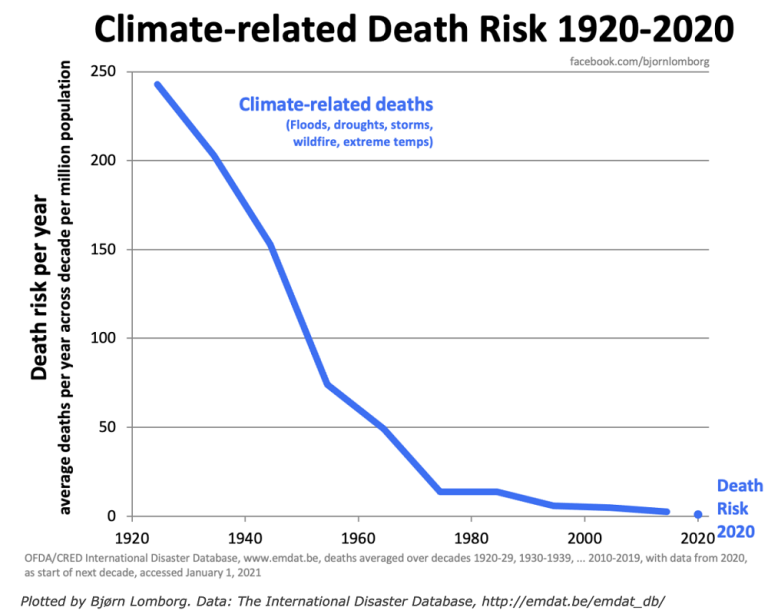
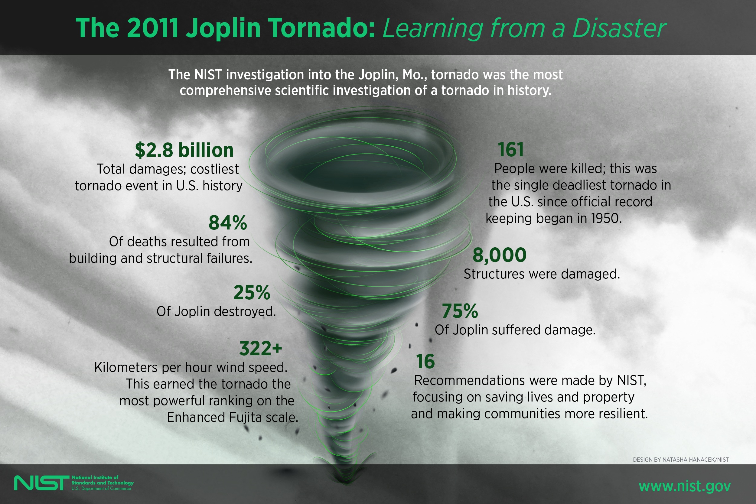
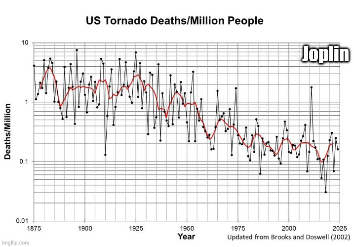
Despite this, there are still limitations based on the worst EF5 tornadoes like the one that struck Joplin, MO in May 2011!
https://en.wikipedia.org/wiki/Joplin_tornado
We should note that the scale below is LOGARITHMIC in order to keep the data manageable because of the tremendous drop in values.
The highest numbers on the left top/left that are approaching 10 deaths/million are actually 100+ times greater than the lowest numbers on the right that are LESS THAN .1 deaths/million!
The Joplin tornado in May 2011 caused the huge spike higher and 1 outlying year since the 1970's.
++++++++++++++++++=
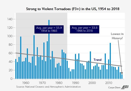
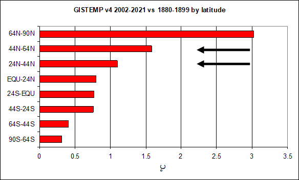
Climate change has been helping too by warming the highest latitudes the most and weakening cold fronts and jet streams! This has reduced the number of the strongest tornadoes by around 50%!
This thread is about TORNADOES not about other impacts from climate change.
May 29th, 2019 by Roy W. Spencer, Ph. D.
Weather becomes LESS extreme in several realms when you reduce the planets temperature contrast with latitude!
Hey mm,
Just wanted to say thanks for all the educational "stuff" you take the time to post and explain on this site.
I wouldnt be exposed to it otherwise. A lot of that "not be exposed to it" is my laziness but much is , I guess, not having been made aware or piqued of/to it.
Hope this is somewhat clear- its a compliment.
John
Thanks very much, John!
That was a high end compliment that means a great deal to me and is much appreciated. We have several thousand people that are readers but don't post and one of my biggest objectives is exactly what you just described for those people.
I've noted from the past that you're comments suggest you're true gentleman with a positive outlook and loads of intelligence and respect for others here...........that doesn't let political differences interfere when communicating.
I know where several of our posters live already. I forgot where you live? So I can keep that in mind when forecasting weather.
You know this but my weather is Evansville IN-centric not just because I live here but we have 1,000+ readers that follow during severe weather events from our county and many of these posts are localized for them but I try to keep the big picture in mind for everybody..........while having fun and learning myself. Not just weather but other stuff, especially trading, climate and politics.
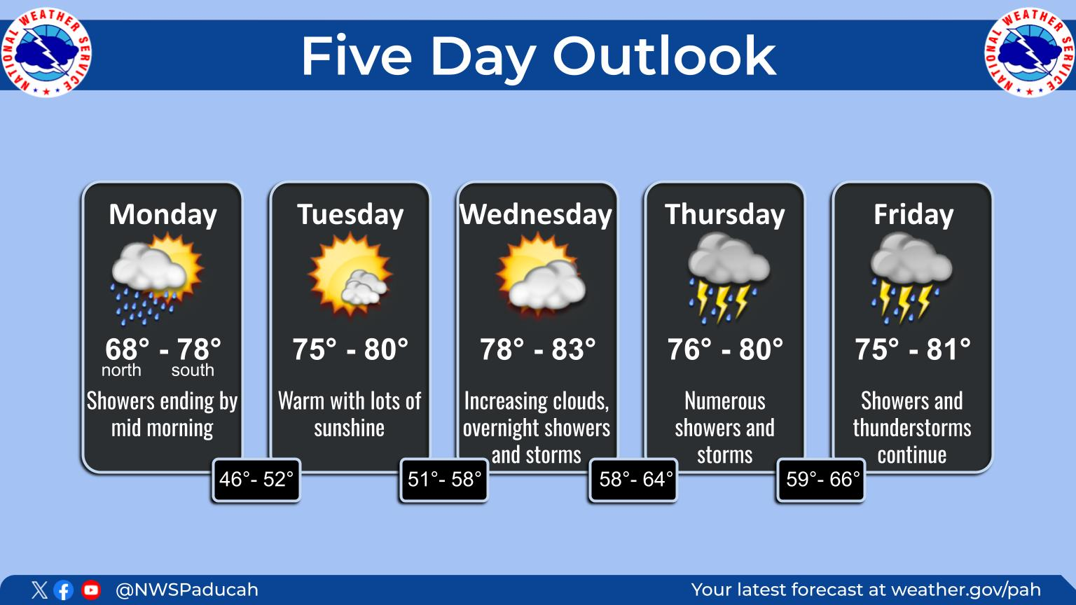
Not much change in the outlook since late yesterday but we should get updates today with changes as we get closer to the event. Good chance for them to update to a moderate risk over Evansville.
https://www.spc.noaa.gov/products/outlook/day2otlk.html
1. Overall risk
2. Risk for severe storm winds. Center is 45%+ within 25 miles of any 1 points.
3. Risk for a tornado 5%+. There could be a strong tornado.
Thanks for the kind words Mike.
I'm located in Toms River NJ-coastal mid jersey. Im not on the water but nearby. We are affected largely by the coastal sweep. I enjoy watching your stuff mid-west and the southern turmoils travel across and up to metro NY. That generally includes enough of my area to satisfy the curious. I have history in western SC and coastal NC adding to mix.
I enjoy checking in around here for some conversation, opinions and adding my 2 c now and again. I dont have much appetite for arguing- not to say I dont excited, pissed or discussed like the next guy but live and let live-"do onto others" etc etc . People dont screw with me too much too long cause I do bite and things work out. I've got more than a few bumps. Watcha think? , ya get it for free? Hee Hee.
I love the character studies
John
Great comments, John.
That was a whopper of a snowstorm that you guys got last month! Maybe some of the biggest snow piles not completely melted yet?
Nor'Easter
21 responses |
Started by mikempt - Feb. 22, 2026, 12:53 p.m.
https://www.marketforum.com/forum/topic/118086/
++++++++++++
On the other hand, you've had some decent snow melting weather recently. This was the last 2 weeks below.
https://www.cpc.ncep.noaa.gov/products/tanal/temp_analyses.php

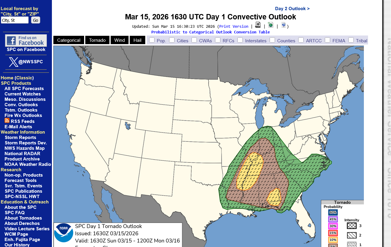
The only change since yesterday is the Storm Prediction Center doubling the chance for tornadoes(potentially strong) to a 10% area, that get's up to the Ohio River. We should note that these shaded areas are not like a well defined boundary between different things on either side. They are GENERAL geographical areas that highlight X amount of estimated risk which can extended BEYOND the boundary when the event unfolds.
https://www.spc.noaa.gov/products/outlook/day2otlk.html
1. Pretty close to yesterday's map. 45% chance of a severe storm within 25 miles of any point.
2. Tornado risk bumped up to 10% in yellow area within 25 miles of any point.
3. Risks move rapidly to the East Coast on Monday

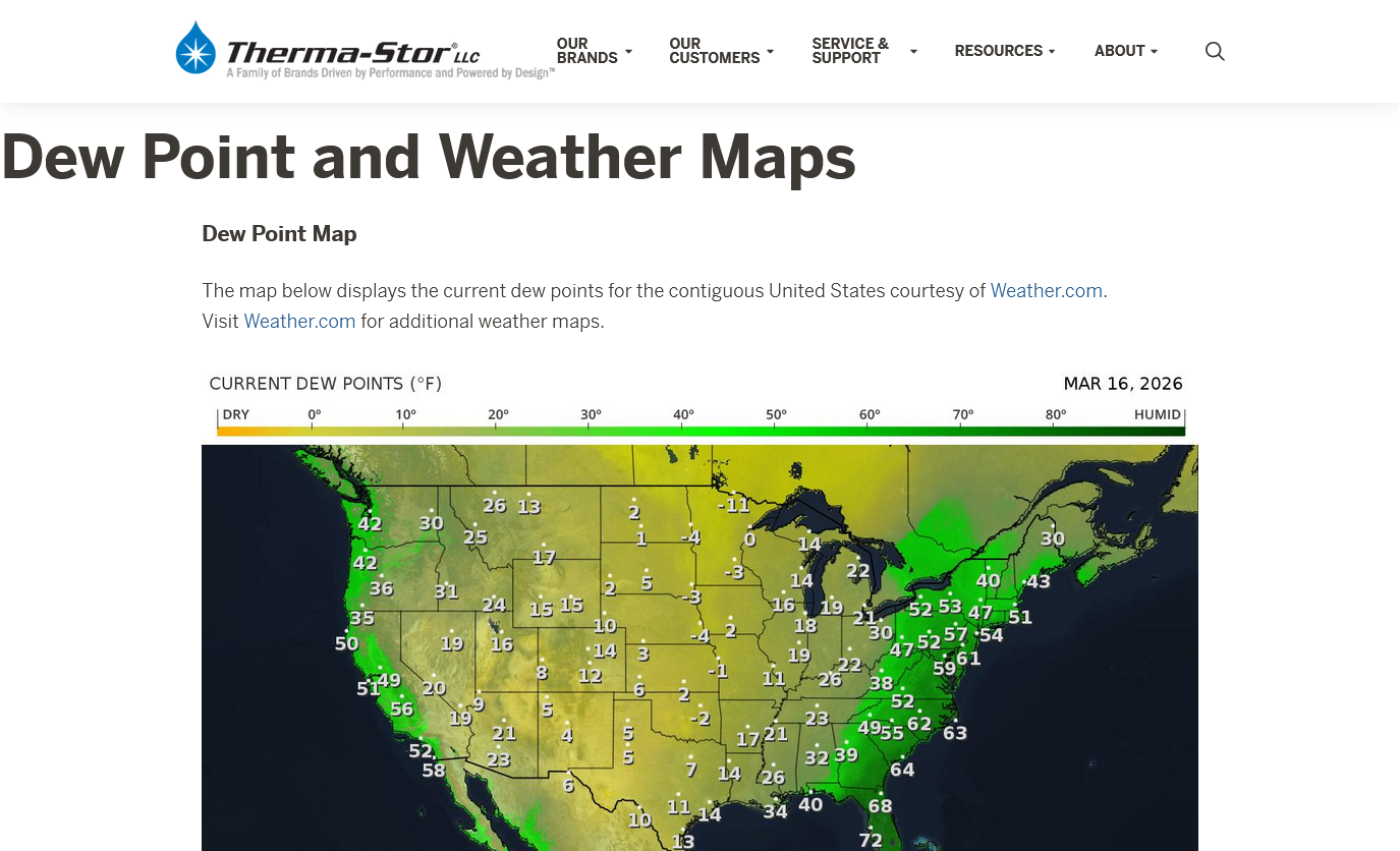
The ingredients are in place for this storm to rapidly develop on Sunday. The biggest missing ingredient will be high moisture from the Gulf of Mexico which will REDUCE the instability(a good thing).
The maps below are from 4pm.
https://www.mesonet.org/weather/air-temperature/national-wind-chill-heat-index
https://thermastor.com/dew-point-and-weather-maps/
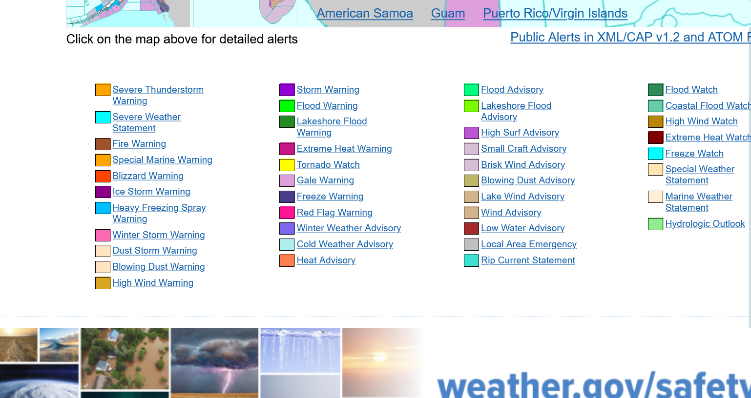
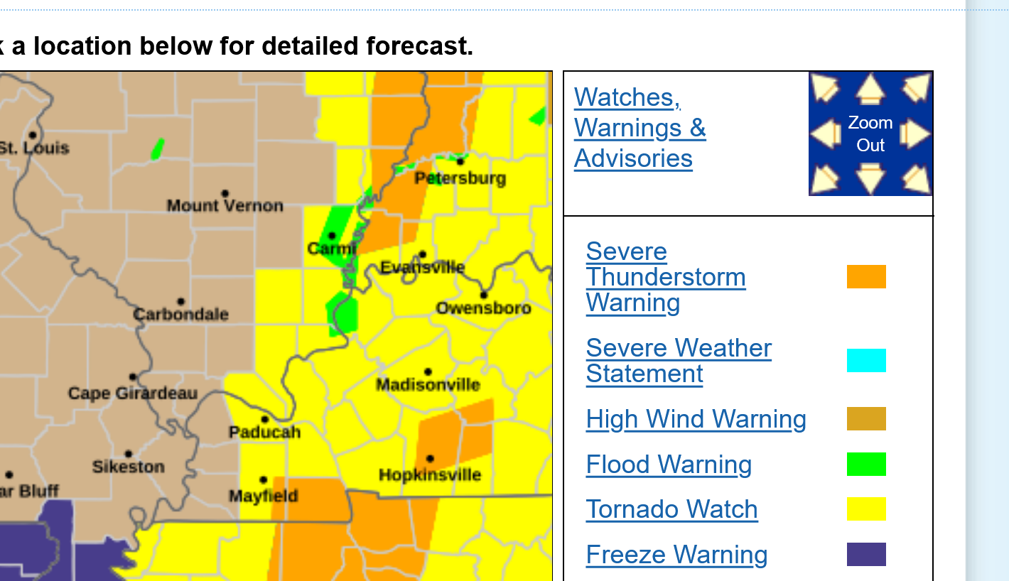
Current Hazards at the link below. These maps will be updated constantly for you.
For your NWS and county, go to the link below.
Then you can hit any spot on the map, including where you live and it will go to that NWS with all the comprehensive local weather information for that/your county.

Current Conditions below updated every few minutes.
https://www.spc.noaa.gov/exper/mesoanalysis/new/viewsector.php?sector=19

Not everybody is going to have severe weather on Sunday. However, 100% of the area will have the extreme cold on Tuesday morning which will cause varying degrees of damage to vegetation that is advanced ahead of schedule by the recent warmth.
The early blooming flowers will all be killed for this year. They are perennials and will return next year. Buds on other trees and plants that are advanced will receive some damage, depending on the plant/tree and how far along. I think alot of them have not started swelling enough to be killed(hopefully) Trees/plants that are flowering early right now could see the blooms killed before they set. Early leafing trees may lose their small leaves and need to start over in a couple of weeks after they recover.
This doesn't happen to this extent often enough to accurately predict the consequences. Regardless, all the trees and plants will recover even if we see losses this year. The losses would be much greater if this happened in several weeks.
This was the warmth the past 2 weeks:
https://www.cpc.ncep.noaa.gov/products/tanal/temp_analyses.php
These are the predicted lows for Tuesday morning, by far the coldest. This cold snap will be sharp but brief. An air mass this HUGE does not miss!
https://www.marketforum.com/forum/topic/83844/#83851
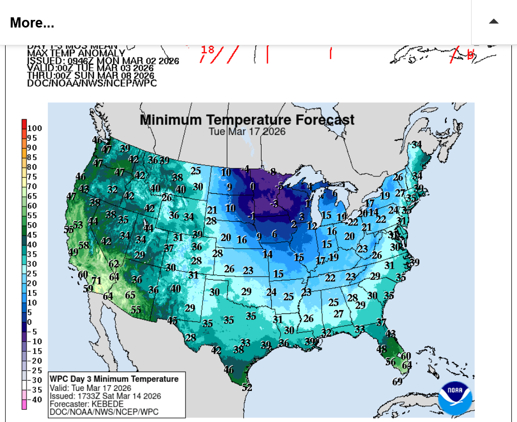
The record low for March 17th is 13 Deg. and we should be close to that.
Yes Mike, the snow has been gone for a couple of days but lingered longer than most of us wanted-its just not that much fun anymore. We got an honest 18 with some drifting. My brother in near coastal RI was well over 30.
I'm checking out that weather link you just posted. Never much got into that before but now with some extra time on my hands Maybe I'll delve in a bit more..
So you say theres some dangerous cold coming- lots of plant people around here - ornamental types- if the cold doesnt get them (the plants) the deer will. I'll hoist the colors and start a conversation. Im in a 55 and older community and could cause some increased resident blood flow by doing that. Maybe just to shake things up!!
Thanks, John!
It's hasn't been warm enough where you are to bring plants very far out of dormancy, so they are still protected. We've had numerous 70's and even low 80's on 2 occasions. That will wake up plants/trees from their protective Winter slumber pretty quick.
I'm thinking the fruit orchards and Winter wheat might be ok just based on the red azaleas outside our kitchen window that I look at every day. That is just a guess because they are so different but I watch those particular azaleas the closest every Spring to monitor how far they are from blooming. Right now, their buds are still tiny and they probably won't be hurt. There could be some other anomaly that's suppressed their normal development(the very dry weather until this month) but hopefully this will be the case elsewhere.
Our crap apple trees are just the opposite. Those buds are just barely starting to flower this morning. I fear that the intense cold is going to kill all the blooms.
It's interesting that when we have an early bloom like this, followed by a non killing, extended cold period that it actually EXTENDS the blooming of the beautiful flowering show by Mother Nature.
At the other end, when was have a COLD start to Spring that delays the blooming, then get hit with very warm weather in April, it ACCELERATES the blooming/development cycle and SHORTENS the period of beautiful flowering to less than half.
Whether the plants are in the full sun and how much sun we get matters too because the sun angle has been climbing since Dec. 21st and is almost halfway to the peak on June 21st. The suns direct warming rays are getting pretty powerful and even on cold days they warm the ground/plants at the end of their path.
Our crab apple trees that get mostly sun in the back are a week ahead of the ones in the front that have mostly shade. Orchards would be full sun.
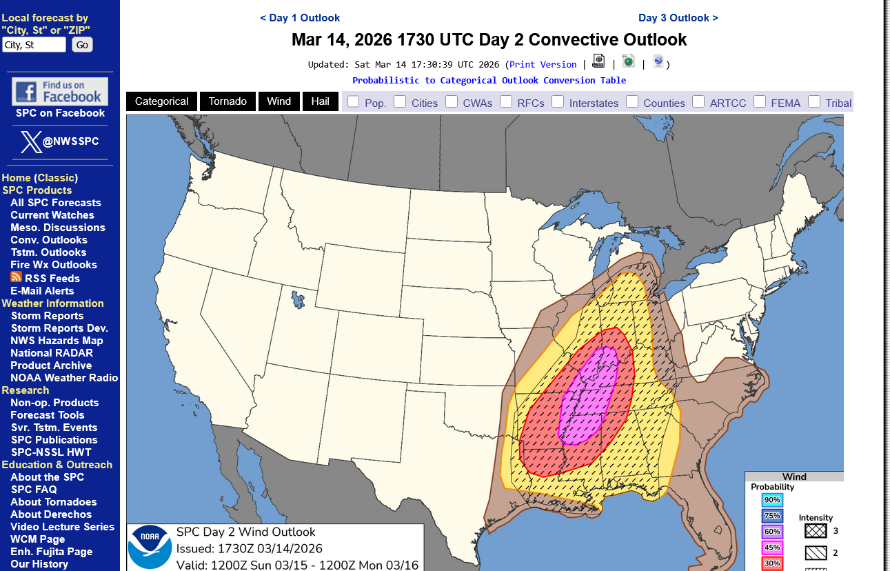
Usually, as we approach significant severe weather events, the Storm Prediction Center will start out conservative, days in advance and as we get closer, typically will INCREASE the risk levels as the empirical data going into the models is updated/fresher.
The slightly good news this morning is that they have actually slightly reduced the tornado risk in Evansville by a tad (after increasing it a day earlier). In the overall picture its not noteworthy but as I mentioned a couple of days ago, this is an unusual system and the ingredient that it will be most lacking is deep Gulf of Mexico moisture.
Even with powerful south winds today increase our dew points, the most favorable 60+ dew points will not likely make it this far north.........and so they shifted the HIGHEST tornado risk (10%+ for a tornado-possibly strong within 25 miles of any point) slightly south in the 60+ dew point environment.
Compared to yesterday, it's tiny and as mentioned, these are NOT well defined boundaries that separate X from Y for instance. They are just general areas that represent the likely risk zones with tremendous uncertainty because tornadoes especially are not uniformly occurring events that blanket the area like cold air behind a cold front. They are random variation events that are triggered by extreme, short term perturbations that are impossible to predict until the event has already unfolded.
https://thermastor.com/dew-point-and-weather-maps/

https://www.spc.noaa.gov/products/outlook/day1otlk.html
This was yesterday below. I'll bet you wouldn't have noticed the tiny difference to retract the yellow shade above in western KY if I hadn't pointed it out. The point is mainly that the risk went DOWN a smidgen instead of going up like it usually does and I noticed that very subtle difference from following it so close.
They elevated the risk slightly in AL/GA on the latest map above. This was Saturday's map below.

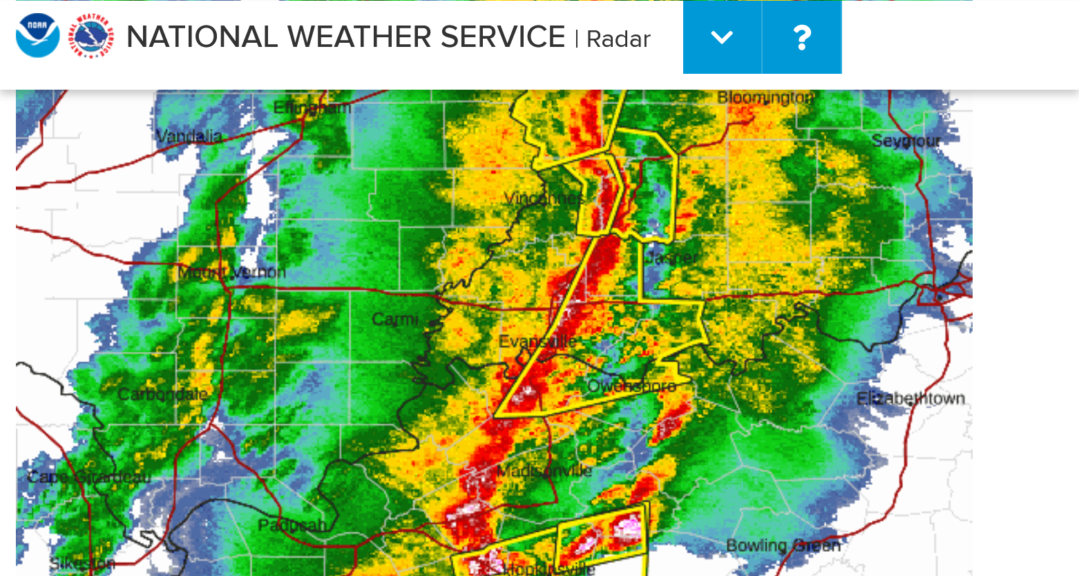
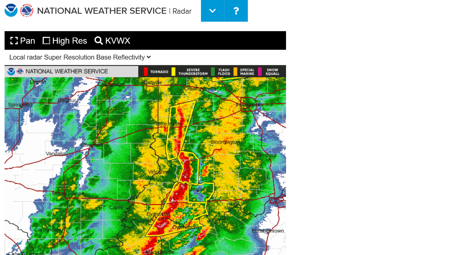
So the brown shaded areas could still have a strong tornado, even though the chances are highest in the yellow shaded locations..........as of 9am Sunday. At 6pm, in the middle of the event it will be pretty obvious with local radars actually making observations of what is happening in real time, telling us what weather models predicting the future can't .
This will be shortly before the storms hit Evansville. It's possible there won't be much severe weather here this time. I've seen stronger jet streams and much more unstable air before.
I'll wild guess that the mostly likely time for this line to come thru is around 8pm or so. Very likely BEFORE midnight. There won't be a lot of thunder and lighting when dew points are this low.
11:30 am: OK, after that long winded dissertation above, their just updated graphic shifted the 10% chance of a (potentially strong) tornado BACK NORTH. The area increased that's most noticed when comparing is S. Illinois but please don't cause this to mislead you into thinking this is anything more than a general outlook. Places CLOSE to but on the other side of the yellow, brown or green shades should be assumed to also have a similar risk.
You can read the latest, just updated forecast philosophy from the Storm Prediction Center here:
https://www.spc.noaa.gov/products/outlook/day1otlk.html
+++++++++++++
To get a heads up BEFORE they issue watches, go to this link for their mesoscale discussions:
https://www.spc.noaa.gov/products/md/
12:45 pm: I’m at Chuck E Cheeses with our 3 year old grandson, Cyrus and can’t post graphics but the SPC just posted 2 mesoscale discussions to let us know that 2 different tornado watch boxes will be issued shortly for far northeast TX, AR, MO into far western IL.
The peak tornado winds they mentioned are 130 mph. Which is AT THE TOP OF EF2 magnitude. That’s a serious tornado of course and you need to go to your safe place with tornado warnings but thats not the type of tornado that kills most people, which are even stronger than that.
They will be issuing multiple tornado watches the rest of the day, 1 of them will cover Evansville later in the afternoon. The tornado threat will increase, especially when the 60+ dew points arrive to those places later this afternoon which adds additional instability.
We have our first tornado watch of the day For MO to W.IL.
I would have your electronic devices charged up just in case we lose power. That’s a good idea in every situation like this which will happen at least half a dozen times every year.
Keep in mind that the SPC never elevated the risk to higher than 3 out of 5. Probably from the uncertainty but this risk is not extreme.
Back home. The high wind warning was an update from the previous advisory as actual winds today are a bit stronger than predicted earlier.
https://www.weather.gov/pah/weatherstory
This was the original forecast below
Current Conditions below updated every few minutes.
https://www.spc.noaa.gov/exper/mesoanalysis/new/viewsector.php?sector=19
Current Hazards at the link below. These maps will be updated constantly for you.
For your NWS and county, go to the link below.
Then you can hit any spot on the map, including where you live and it will go to that NWS with all the comprehensive local weather information for that spot.
 The orange color in a large area of the Upper Midwest is a Blizzard Warning!
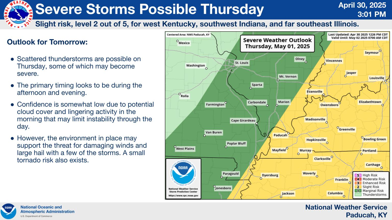
Heads up for folks living in the Mid-Atlantic. Tomorrow is a level 4 out of 5 risk in places outside of traditional "tornado alley".
Here's comes our Tornado Watch later this afternoon. Now that more moisture is getting pulled in, they increased the top wind of tornadoes to 150 mph which is EF3. That's serious tornado business. I'm surprised they never increased our risk to level 4, moderate which would normally be the case for EF3 tornado risks. Be ready to go to your safe place in the event of a TORNADO warning this evening, especially if the warned storm HAS A HISTORY.
Wind gusts in severe thunderstorms to 80 mph.
https://www.spc.noaa.gov/products/md/md0246.html

They mentioned the chance for QLSC tornadoes.
What the heck is that?
++++++++++++
Tornadoes typically form from large thunderstorms, but recent research indicates that they can happen during lines of storms as well.
++++++++++++++++++
https://www.youtube.com/watch?v=zNwkVuTC19c
Stay on top of it with this guy!
I love Ryan Hall Y'all!
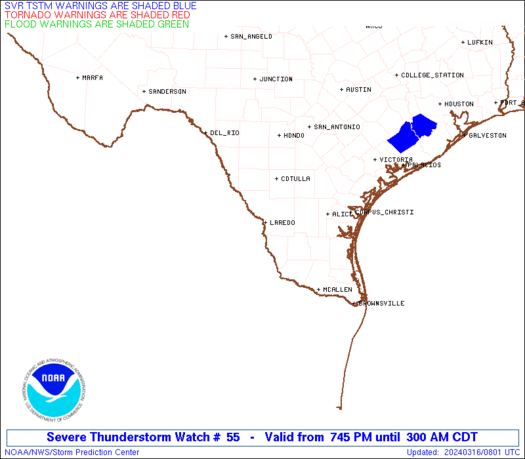
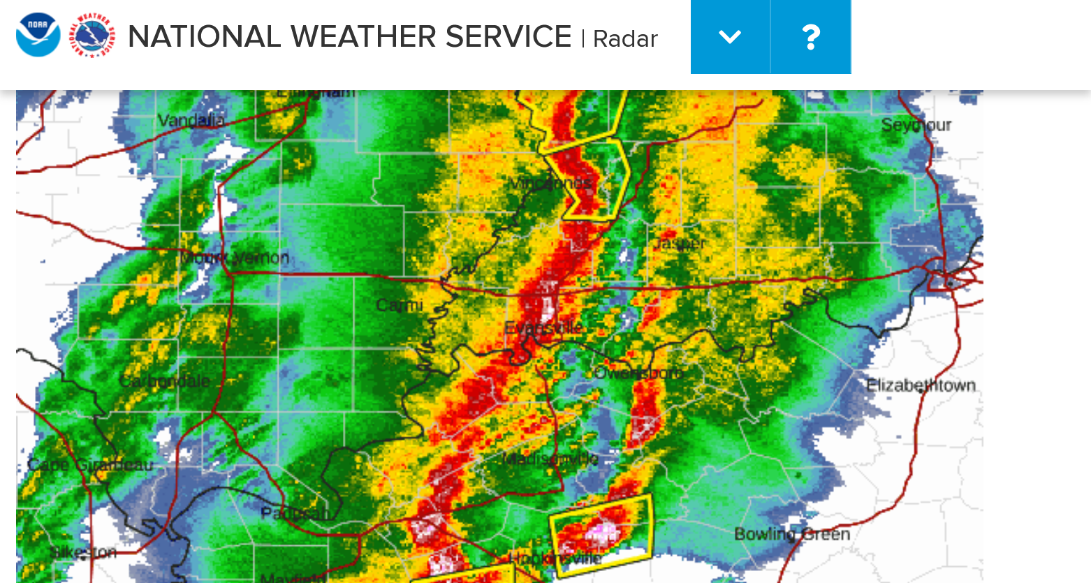
We got the tornado watch. The blues below WERE the severe thunderstorm warnings. The reds WERE the tornado warnings when I copied the map. Go to the link for the latest. The map below is continually updated
No strong tornadoes reported yet. The storms are still developing. With us in the northeast corner of the watch which expires at 11pm, we can guess that the storms will be getting close WELL BEFORE 11 pm.
They mention the upper end of tornadoes being a strong EF2+. However, this verbiage is,not present.
"This is a particularly dangerous situation"
Again, that is NOT mentioned. They will use that language for the most dangerous, life threatening events. This event is just UNDER that.
https://www.spc.noaa.gov/products/watch/ww0055.html
No tornadoes reported yet but its early in the event. The map below is continuously updated.
https://www.spc.noaa.gov/climo/reports/today.html

Distant Storms are getting picked up on our local radar.
The county map with warnings and the radar below are constantly updated.

The rain cooled air from these showers BEFORE the main event might stabilize the air some.
The Weather Channel is providing great coverage right now too.
Does this seem like the most coverage of a severe weather event in history?
Does that mean the risk is proportional to the coverage?
Yes and No!
Yes, the advancing technology allows us to do more and more things every year so that our coverage is greater and BETTER.
The number of strong tornadoes, if there are any tonight will be LESS than many outbreaks/events in the past that got less coverage because the technology was not as advanced in the past.
The most deadly and biggest tornado in history was on March 18, 1925. Everybody found out about it..................when it was clobbering them. Nobody went to safe place. A similar tornado today would result in MUCH LESS loss of life.
So this OVERkill coverage is the maturing of an industry that has saved countless lives by informing people and making these events, the safest they've been in history.
As Ryan likes to say "don't be scared, be prepared"
40,000 people a year are killed in car accidents. 40 from tornadoes. That's a factor of 1,000 difference.
Very few people are afraid to travel in their car to go where they need to go. We put on our seat belts and take on that risk day after day to the point where its an accepted part of technology. 150 years ago, very few people got killed from riding a horse. The technology of transportation is MORE dangerous(flying by the way is actually safer than driving/mile) but accepted by all of us because of the incredible benefits.
The technology in meteorology is saving countless lives by making us aware of risks that we were blind too previously. The technology of forecasting, tracking and warning for severe weather actually is EMPOWERING us. We should embrace that along with the understanding of what it is and the REALISTIC view that even in the highest risk tornado outbreak, the chance of being killed is very tiny. And it's even smaller when you are prepared and go to a safe place.
The objective is to reduce the chances of being injured to as low as possible for the very few people in the path of a strong tornado.
The other 99.99% of people that live in that area NOT in the path of the strong tornado that day should have the peace of mind knowing that they were informed and prepared and knew where to go IN CASE the tornado hit their home.
So instead of fearing the potential ahead, embrace the peace of mind mentality from being informed and empowered by knowing what to do, unlike most of our technology deprived, vulnerable ancestors!
And appreciate the amazing power of nature, realizing that regardless of our technology, there are some things that are even MORE powerful than human beings. Many of them beautiful and beneficial, some of them dangerous.
We live in the best age of human history by an extremely wide margin when it comes to technology, science, medicine, entertainment, communication. We've advanced MUCH more in the last 150 years than we had the previous 15,000 years combined.
If any of us had a time machine and could go back 150 years for just a day, let's say in the middle of Winter we would be better able to embrace how lucky we really are.
This is a snapshot of the last warning map(actually, it looks like that map is being updated on this page)
Holy Cow! Those are all WARNINGS!!!
Looks like around 15 counties with a tornado warning and around 50 counties with a severe thunderstorm warning. This has likely happened before but not when I was following it like this.
Note that tornado warnings are happening farther north of the higher risk denoted by the Storm Prediction Center. The image from the description above is gone, unfortunately. It was pretty impressive.
It's impossible to imagine that we won't have some warnings in Evansville . The good news is that I don't know of any tornadoes, yet alone strong tornadoes.
8 pm: This map below is a snap shot, the one above is constantly updated and now it is possible to imagine that we MIGHT only have a few warnings with a 1,000 mile long line of storms with warnings all along it..........except for the part aimed at Evansville! Maybe the rains earlier this evening helped stabilize the air mass.
There are other tornado watches besides the one shown on this graphic but this graphic shows all the warnings.
This is the live link:
https://www.spc.noaa.gov/products/watch/ww0055.html

This warning does NOT include us, just the northwest part of Vanderburgh County and its NOT a tornado warning.
There have been NO tornadoes reported. I think we may get a break but the coast will not be clear for an hour or so. The time stamp at MarketForum is in EDT, 1 hour ahead of Evansville.
I would just stay inside and away from windows with this severe thunderstorm warning.
This is a snapshot at 8:40pm to look back on later.
There have not been any tornadoes reported anywhere today. The HISTORY of the past few hours gets tremendous weighting, MORE THAN the models and forecasts and its saying this system is UNDER performing.
The live shot is at the link below.


The main event is happening in the next 30 minutes in Evansville, over with by around 9:20 pm with LESS severe weather than expected.
+++++++++++++++++++++++=
9pm: The NWS is NOT issuing additional warnings to the east right now as the storms have continued to weaken. Just a special weather statement...for now.
The strongest part of the weakened storms aimed at Evansville appears to be passing by right now just after 9pm.
Our sirens went off for a new warning but the storms are PAST EVANSVILLE!

The severe thunderstorm warning went off everywhere in Vanderburgh county because a tiny sliver of southeast Vanderburgh county was in the warning. The warning is only for areas EAST of Evansville.
9:30pm radar and severe thunderstorm warnings. Every county from north to south east of highway 41 has a severe thunderstorm warming.
Very odd that the storms weakened before tracking over Evansville, then strengthened after passing thru Evansville but we're not complaining.


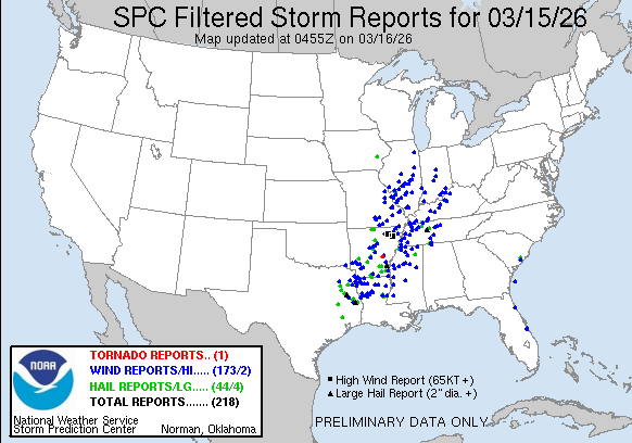
94 severe thunderstorm reports so far today.
Still 0 reports of tornadoes!!!
4am: The map below was continually updated after this post and we did finally have 1 tornado reported with 310 severe thunderstorm winds reported.
https://www.spc.noaa.gov/climo/reports/today.html

Now the cold air pours in!!
Low 70's up to the Ohio River at 9pm. Feeling over 80 degrees colder than that in the Upper Midwest.
https://www.mesonet.org/weather/air-temperature/national-wind-chill-heat-index
173 severe thunderstorm high wind reports, 2 of 70+ mph.
44 hail reports, 4 with LARGE hail.
1 weak tornado!!
++++++++++++++
Only 1 high wind report in the Evansville area.
https://www.spc.noaa.gov/climo/reports/today.html
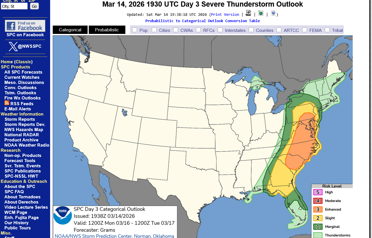
As Mike showed ITT on a map, this could get very dangerous in the E on Monday, especially parts of N SC to VA.
Very true, Larry!
https://www.spc.noaa.gov/products/outlook/day1otlk.html
Categorical risk below. Moderate 4 out of 5!
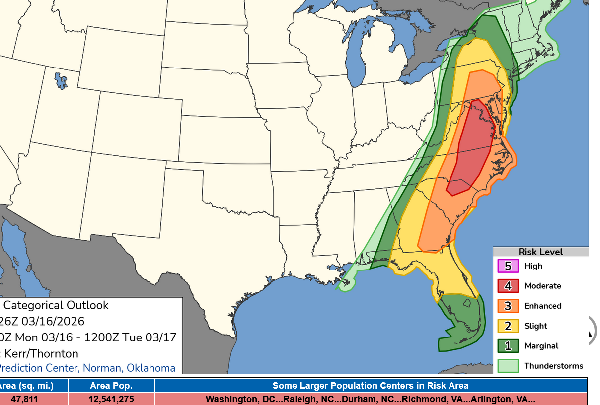
Tornado risk below:
High wind risk below:
We should probably start a new thread on Monday!
The cold air is dumping in fast!
https://www.mesonet.org/weather/air-temperature/national-wind-chill-heat-index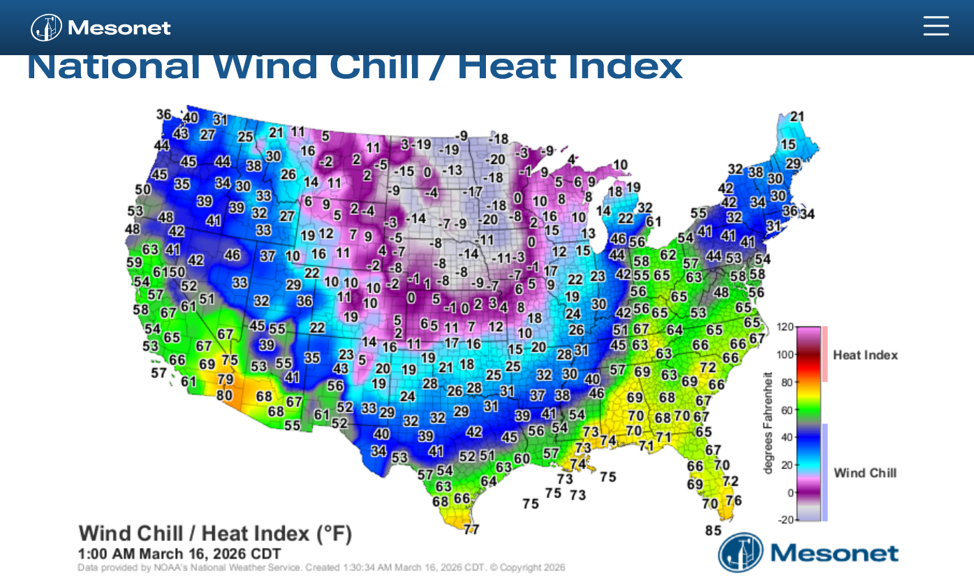
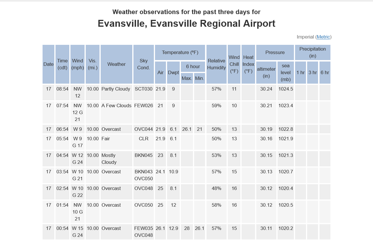
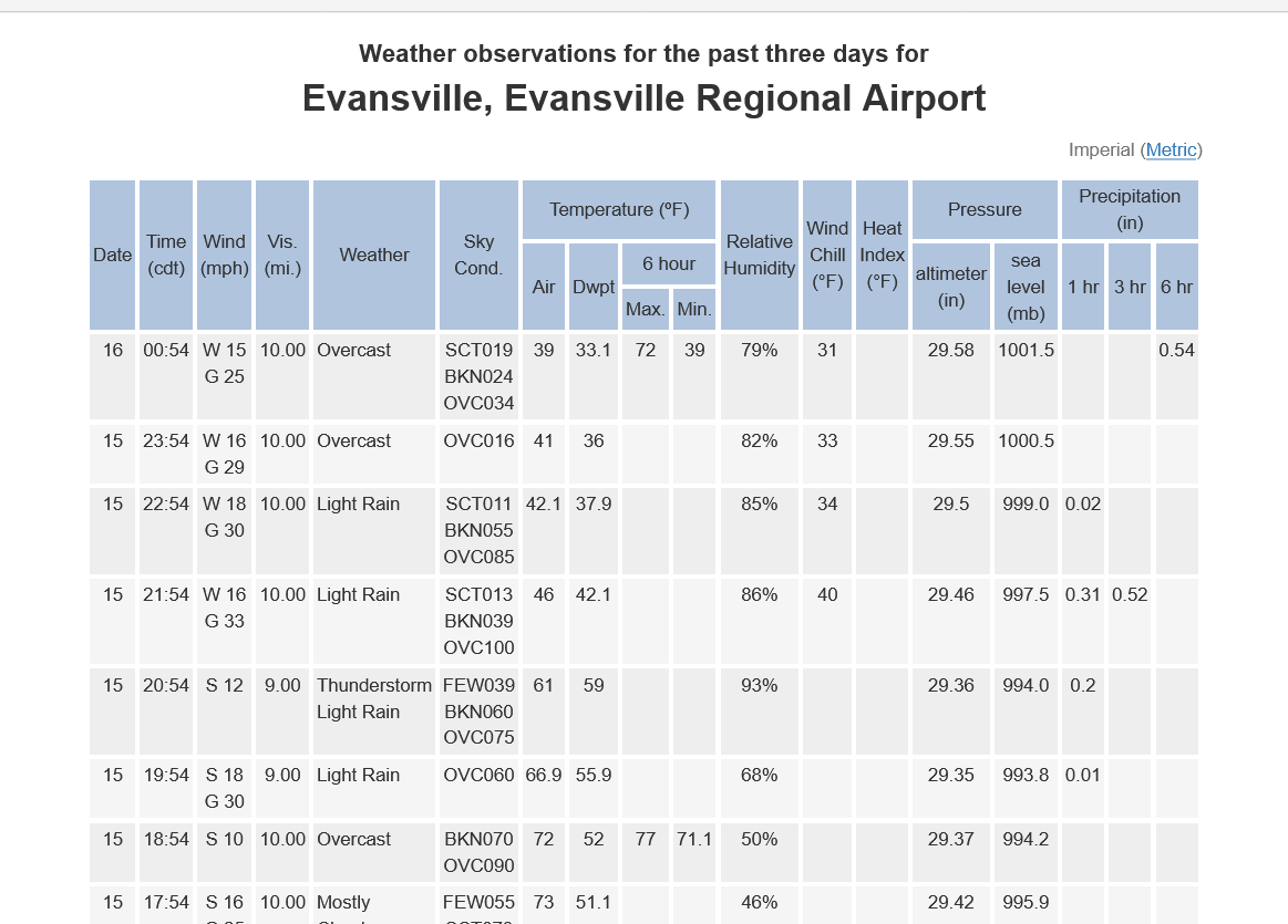
Temperatures have dropped 34 degrees this evening.
https://forecast.weather.gov/data/obhistory/KEVV.html
Current Conditions below updated every few minutes.
https://www.spc.noaa.gov/exper/mesoanalysis/new/viewsector.php?sector=19
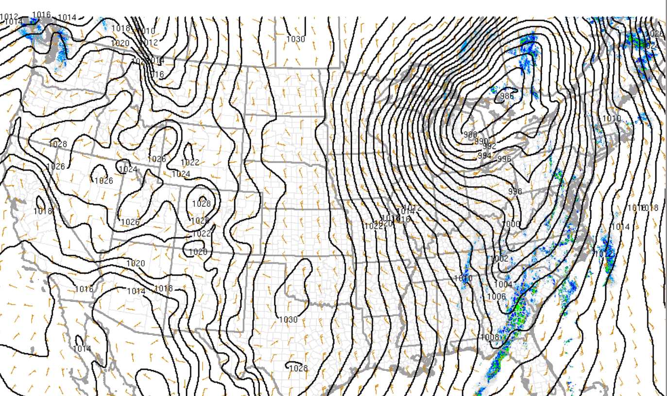
2am surface map below
Extremely deep low pressure center and tightly packed isobars!
The storms have continued to track southeast with numerous severe thunderstorms warnings and reports of high winds but less than yesterday evening and still only 1 tornado (in Arkansas) for the entire event.
Rhings will get revved up again later today.
I”ll be away from home mid afternoon On Monday.
Deep lower pressure, with a center now just northeast of Lake Huron and moving into southeast Canada. Tight pressure gradient on both sides. Southerly winds pulling up warm/moist air ahead of it, nw/n winds behind it with very cold Arctic air.
It feels 80+ deg. F colder in the Upper Midwest right now compared to the Mid-Atlantic!!!
https://www.spc.noaa.gov/exper/mesoanalysis/new/viewsector.php?sector=19
https://www.mesonet.org/weather/air-temperature/national-wind-chill-heat-index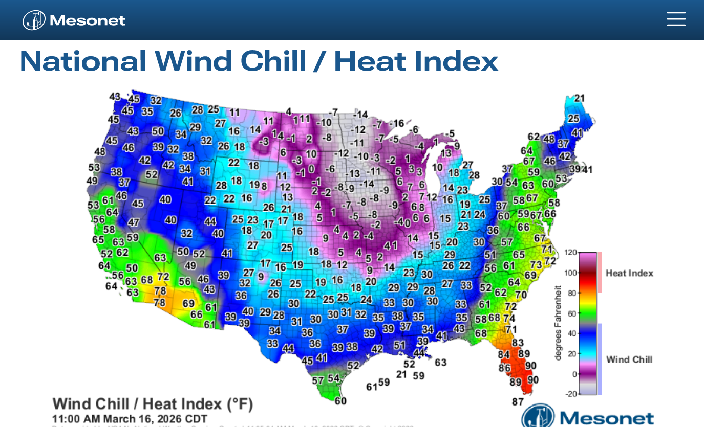
The Storm Prediction Center uses a 24 hour, daily time frame from 7am to 7am the next day to tally their stats.
This is what they had thru Monday morning for the previous 24 hours. Additional reports were still coming in from the active storms on Sunday that were unknown until numerous hours AFTER the storms hit.
This is from the 24 hours 7am Sunday to 7am Monday: They are still adding up.
1. 610 severe storm winds
2. Just 5 (weak?) tornadoes
3. 78 hail reports
https://www.spc.noaa.gov/climo/reports/260315_rpts.html
These reports are still coming in. Our area in Evansville IN only had 1 severe wind report based on what I can see.
This didn't copy well but its a 64 mph wind gust measured by an ASOS instrument in Melody Hill, 2 miles north of Evansville. 0201 was 9:01pm CDT but I'm thinking that should be 10:01 pm?
We were having crazy wind gusts at different times yesterday and some were not associated with severe thunderstorms.
My wife,Deb just told me that we have a pretty big tree down on the other side of our garage.
| 0201 | 64 | 2 N Melody Hill | Vanderburgh | IN | 3805 | 8752 | ASOS station KEVV Evansville IN. (PAH) |
After my doctors appointment it’s off to get a new chain for my chain saw.
A large dead tree completely snapped on the other side of our garage and is suspended about 8 feet up by other trees and bushes in the woods and laying horizontal.
I‘ll need to tie a rope around it and have my son help me pull it down, then cutting it up.
Last April 2nd a decent sized tree was snapped on our front lawn from a weak tornado that I called my sons 37th birthday present.
It was already dead so Mother Nature did me a favor although I had to scramble in the middle of the night because it fell across the street and blocked cars in front of our house.
2 months later another dead tree on our front lawn was snapped and this time I took a week to cut it up and remove it.
the emerald ash borer and its disease has been taking a horrible toll!
Flew home yesterday afternoon into Midway. 63 degrees at 3:33 pm ct. Radio said it was 39 degrees at O'Hara!
Had a 'delightful' last 20 mile on I80 with wind blowing 35-40 and raining like crazy, 43 temp. Woke up this morning with 2 inches snow and winds still blowing--schools called off. Home is Ottawa, Il.
Friday and Saturday back to 70!
Thanks very much for sharing that tjc!
No fun traveling in this kind of weather.
I imagine some flights tracking thru the storm zone were a bit bumpy.
Yes, back up to 70 later this week. By coincidence, that how many cents the beans were down today, locked limit down on the close.
Looks like you’re still getting some snow, tjc!
The NWS did not issue hard freeze warnings this far north because they felt the vegetation was not advanced enough/it was too early in the year. Some of the early blooming trees/plants and flowers probably disagree with that. The hard freeze warnings below in the South are in purple.
Clouds overnight provided a thermal blanket that, along with the wind mixing the air near the ground, preventws the temperature from dropping below 21 degrees in Evansville.
Happy St. Patricks Day!
As will often happen, some severe weather damage is not observed and reported right away, especially from events at night or in rural areas.
Also, when the NWS does survey's, they can access whether the damage came from a severe thunderstorm straight line wind or a tornado.
The map below sure looks way more active than our initial reporting. Still just 1 report in the Evansville area(64 mph wind).
https://www.spc.noaa.gov/climo/reports/260315_rpts.html
1. 21 tornadoes
2. 706 high wind reports(3 above 70 mph)
3. 80 hail reports(4 large hail)