
Severe Storm Risk......updated daily(days 1 and 2 twice daily).
https://www.spc.noaa.gov/products/outlook/
Current Day 1 Outlook | |
Current Day 2 Outlook | |
Current Day 3 Outlook | |
Current Day 4-8 Outlook |
There are 4 key factors causing this severe weather: See maps below.
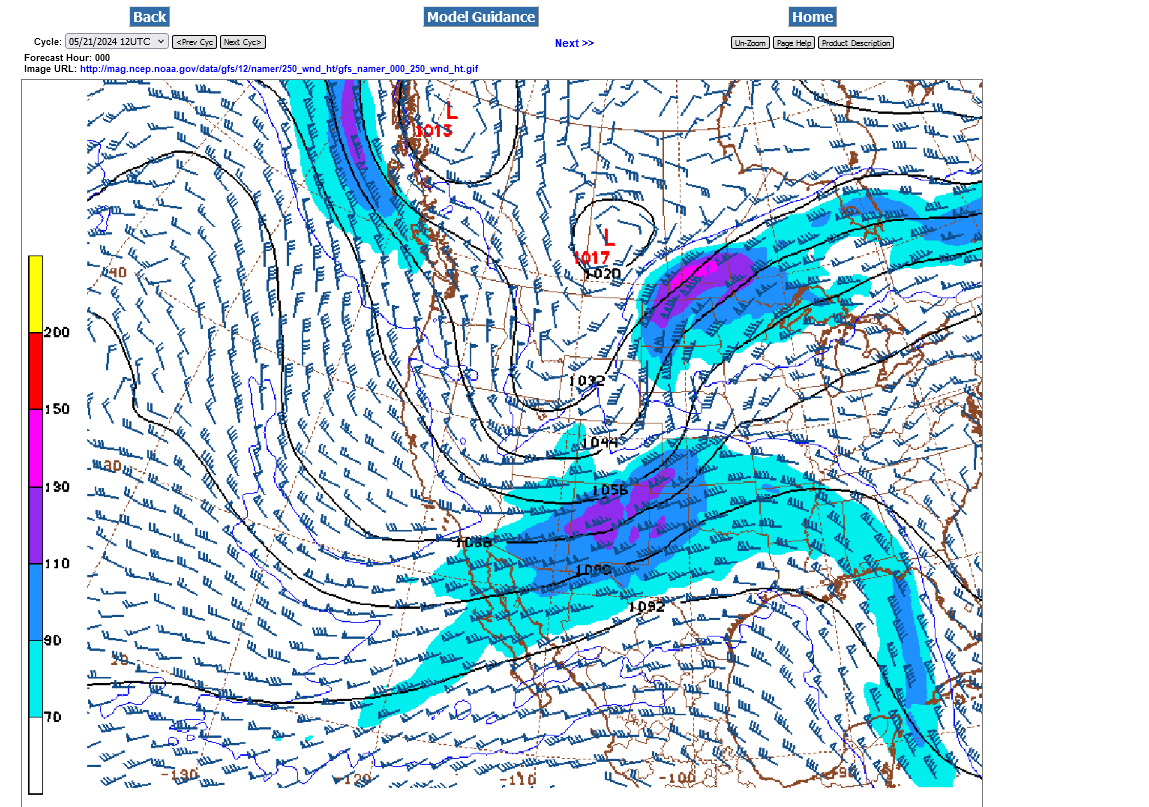
1. Strong upper level jet stream/trough.
2. Vorticity/spin in the atmosphere
3. Very warm/humid air in the lower levels
4. Surface cold front.......see 4 maps below
250 mb winds in knots/hour
500 mb vorticity/spin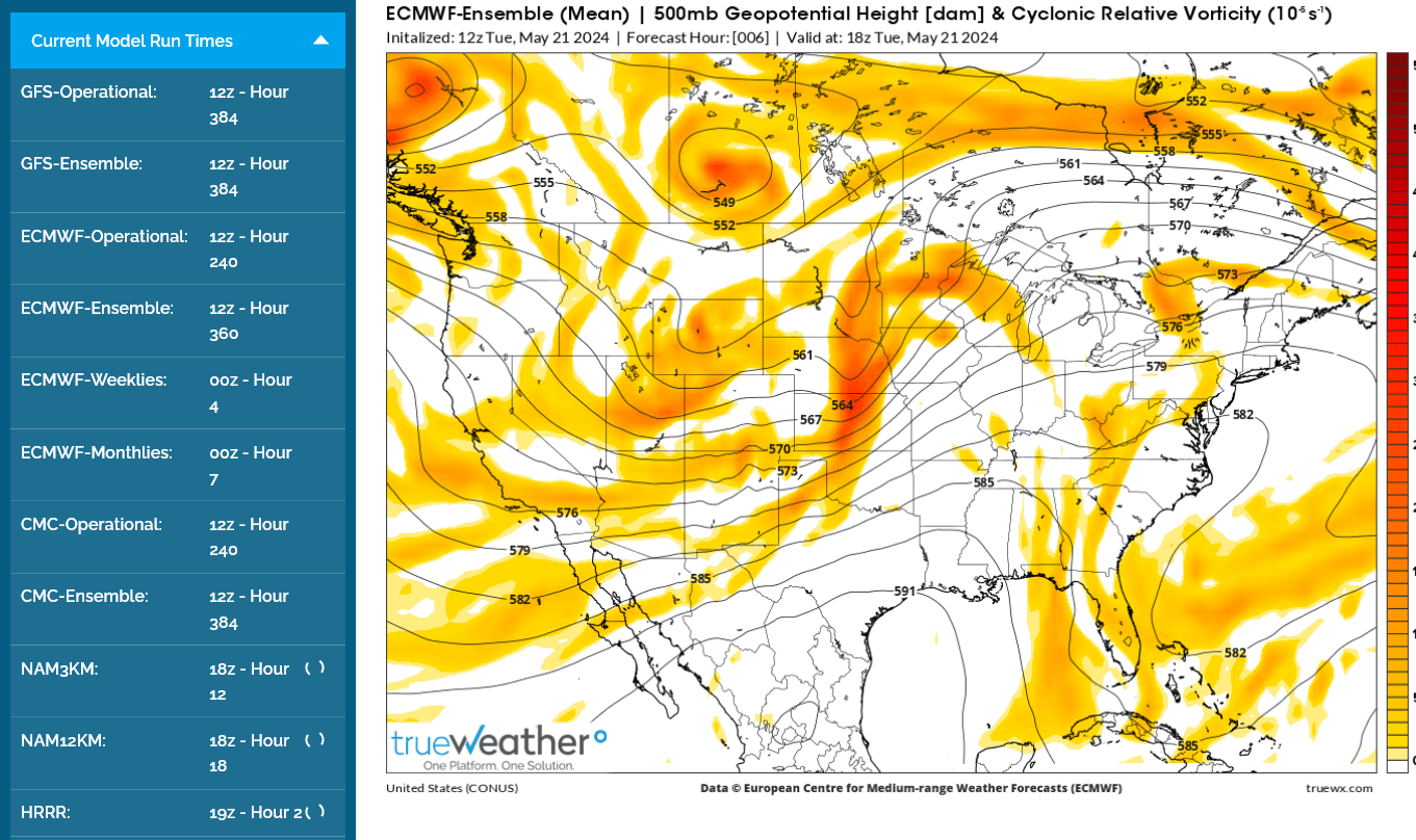
National Wind Chill / Heat Index
https://thermastor.com/dew-point-and-weather-maps/

1. Weather map now.
2. In 24 hours and
3. In 48 hours.
https://www.wpc.ncep.noaa.gov/#


+++++++++++++++++++++++++++++++++++++++++++++++++
Surface Weather maps for days 3-7 below:
https://www.wpc.ncep.noaa.gov/medr/medr.shtml

The latest 7 day precip forecasts are below.
Day 1 below:
http://www.wpc.ncep.noaa.gov/qpf/fill_94qwbg.gif?1526306199054

Day 2 below:
http://www.wpc.ncep.noaa.gov/qpf/fill_98qwbg.gif?1528293750112

Day 3 below:
http://www.wpc.ncep.noaa.gov/qpf/fill_99qwbg.gif?1528293842764

Excessive rain threat.
https://www.wpc.ncep.noaa.gov/qpf/excess_rain.shtml
Current Day 1 Forecast
Day 1 Threat Area in Text Format
Current Day 2 Forecast |
Day 3 outlook

See all the comprehensive weather here:
Current Hazards at the link below.
Go to the link below, hit hazards box in the top right hand corner(it will also define all the color codes), if its not already in the hazards mode when you load the link.
Then you can hit any spot on the map, including where you live and it will go to that NWS with all the comprehensive local weather information for that/your county.

New radar product below
Go to: "Select View" then "Local Radar"
Hit the purple circle to see that local radar site
+++++++++++++++++++++++
This link below provides some great data. After going to the link, hit "Mesoanalysis" then, the center of any box for the area that you want, then go to observation on the far left, then surface observations to get constantly updated surface observations or hit another of the dozens of choices.
 |
Tracking the latest radar with constantly updated surface observations here:
Current temperatures:
https://thermastor.com/dew-point-and-weather-maps/
Current Conditions below updated every few minutes.
UPPER MIDWEST
https://www.spc.noaa.gov/exper/mesoanalysis/new/viewsector.php?sector=13#


https://www.spc.noaa.gov/exper/mesoanalysis/new/viewsector.php?sector=13#

LOWER MIDWEST
https://www.spc.noaa.gov/exper/mesoanalysis/new/viewsector.php?sector=20

https://www.spc.noaa.gov/exper/mesoanalysis/new/viewsector.php?sector=20#

https://www.spc.noaa.gov/exper/mesoanalysis/new/viewsector.php?sector=20# 
SOUTHCENTRAL
https://www.spc.noaa.gov/exper/mesoanalysis/new/viewsector.php?sector=15#
SOUTHEAST
https://www.spc.noaa.gov/exper/mesoanalysis/new/viewsector.php?sector=18#

NWS: Twin Cities, MN
Severe Thunderstorms Across Portions of the Midwest; Hazardous Heat in Southern Texas
A Moderate Risk (Level 4 of 5) of severe thunderstorms is expected across the Midwest today, especially portions of Iowa, Missouri, Wisconsin and Illinois. Damaging winds, large hail and a few strong tornadoes are expected. A dangerous early season heat wave will continue this week and expand from south Texas through portions of the central Gulf Coast by this weekend. Read More >
Click a location below for detailed forecast.


+++++++++++++++++++
NWS Forecast Office Kansas City, MO https://www.weather.gov/eax/


++++++++++++++++++
NWS Forecast Office Tulsa, OK


Fort Smith radar
https://www.youtube.com/watch?v=B3S6mdEMTpM here is what Snodgrass has to say...and its mostly bad news for the Midwest. He does mention around minute 23 a chance for a pattern change in day 8 or so. and that 70 done thing yesterday is shrinking no matter what big gov came out with.
IOWA WIND FARM 27 SECONDS
Thanks, mcfarm and jean!
Storm threat zone has moved east:


Central Illinois
NWS Forecast Office Lincoln, IL
Click a location below for detailed forecast.


Click a location below for detailed forecast.

++++++
NWS Forecast Office Indianapolis, IN
Wednesday's Severe Weather Threat
Another round of severe weather is expected Wednesday afternoon and evening, with the greatest threat for Central and Southern Indiana. All hazards are on the table with damaging winds being the greatest threat. Continue checking back for updates at weather.gov/ind. #inwx
Click a location below for detailed forecast.

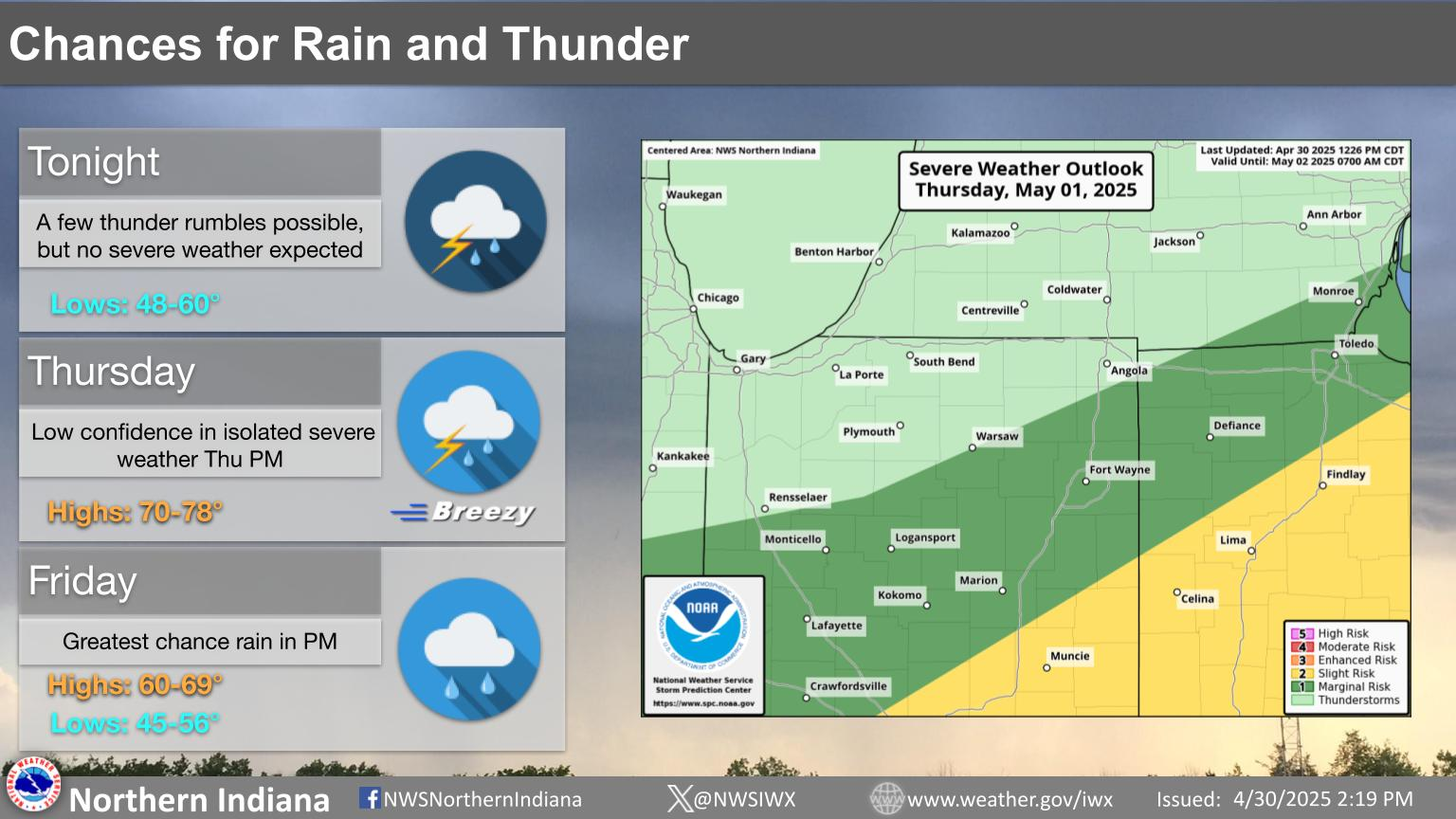
NWS Forecast Office, Northern Indiana
5-22-22: Areas farther south:
Shreveport, LA

There's a Enhanced Risk (Level 3 of 5) and a Slight Risk (Level 2 of 5) for severe thunderstorms across most of the Four State Region later today, this evening and into the overnight hours tonight. Damaging thunderstorm wind gusts and large hail will be the primary threats, followed by an isolated tornado threat.

+++++++++++++++++

L

Severe storms will be possible throughout the day today. All storm modes. Remain weather aware and have ways to receive warnings (and ways that will wake you up!)
 NWS Nashville (KOHX) Radar Loop

++++++++++++++++

Strong to severe thunderstorms are expected Wednesday night (after midnight) into early Thursday morning. Large hail, damaging winds, and tornadoes are the main hazards. Flash flooding may also become a risk due to locally excessive rainfall.

+++++++++++

UPDATE: Strong to severe thunderstorms will be possible tonight into early Thursday morning. The dark green indicates a Marginal Risk (Level 1 out of 5) for severe weather while far west- central Georgia is under a Slight Risk (Level 2 out of 5) for severe weather. Damaging wind gusts of at least 60 mph will be the primary hazard, but a brief tornado cannot be ruled out.

 Weather Story


 Regional Radar
 Shreveport Radar
 Weather Map
 Local Radar