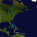
The current pattern with soon to be major Hurricane Lee has some similarities to the pattern with Superstorm Sandy, which was one of the most unusual storms in history BUT NOT UNPRECENDENTED and having ZERO to do with climate change.
It was blamed on global warming/climate change which was absurd considering the pattern was an extreme -NAO, early season cold weather pattern.
Anyways, here we go.
In late Oct. 2012, the deep upper level northern stream trough was expected to steer Sandy away from the coast(like this current one is predicted to do but we're not nearly so deep), then suddenly the models, getting fresh data, reconfigured and realized the upper level trough would PULL IN Sandy and the 2 systems would become a super energized, hybrid storm.
The discussion and maps at this link/source about Sandy is THE BEST one out there by a wide margin!
https://ocean.weather.gov/HurcnSandy/VariousItems/superstorm-sandy_joe-sienkiewicz.pdf
Look at the incredible change in the NHC forecast in just 36 hours!!
1. 5am, Oct 25, 2012
2. 5pm, Oct 26, 2012-36 hours later-WOW!
3. 5pm, Oct 27, 2012-60 hours later
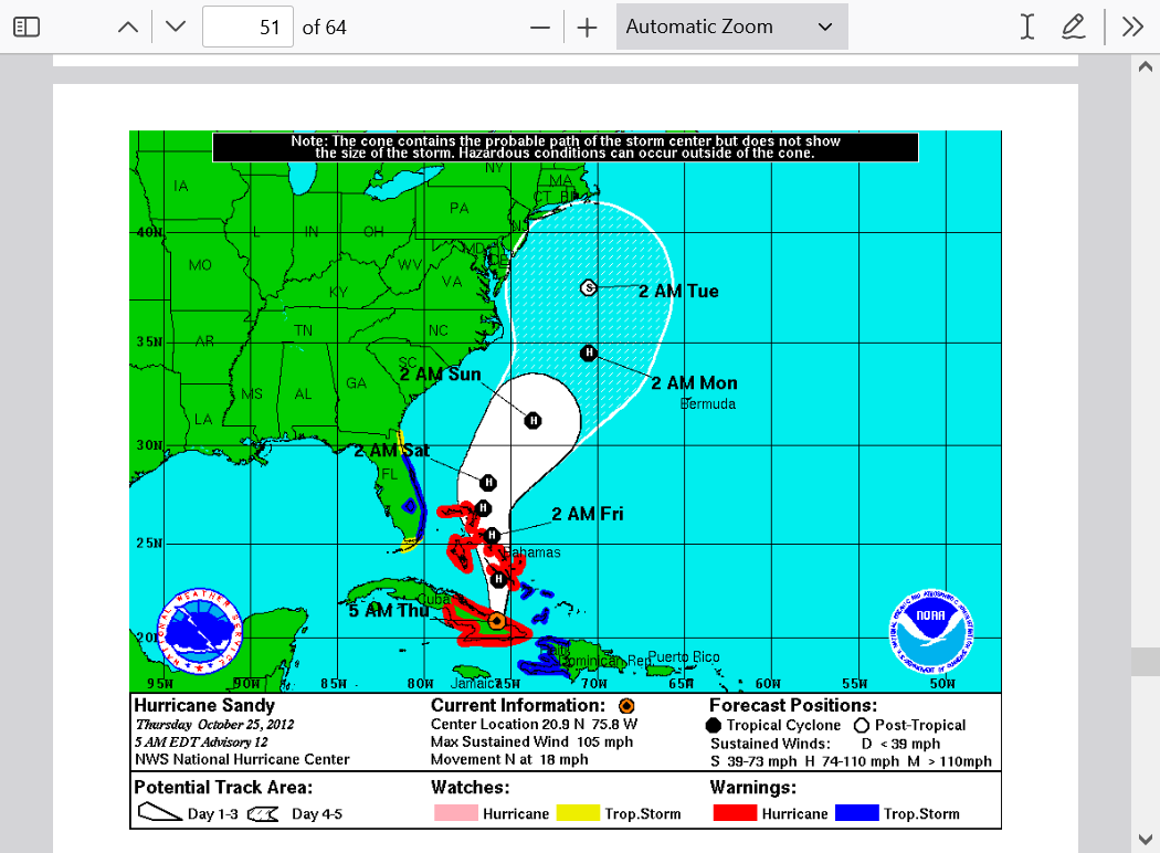
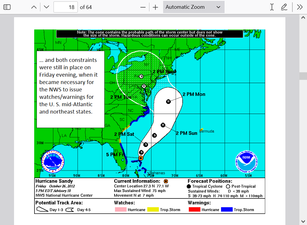
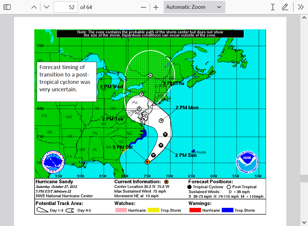
What the heck happened to cause such an incredible change in the forecast track in such a short period of time????
Sandy had 2 potential tracks that were extremely different and depended on a very small change in the position of its location with respect to the Upper level trough to the west.
1. Slightly farther south and be steered out to sea away from the East Coast by the strong jet stream in the base of the upper level trough..
2. Slightly farther north and get pulled/entrained into the unusually deep, early cold season, -NAO trough(one that almost never exists during the hurricane season) and become a hybrid storm with dynamics from the already powerful upper level low, combining with the remnants of Hurricane Sandy.
If Sandy has been 300 miles farther south or the upper level low been 300 miles farther north it would have taken path #1 and nobody would remember it today because it would have been ushered safely out to sea away from the coast by the jet stream!
Instead it found #2 as the path of least resistance and created a hybrid, SUPER storm.
The orange arrows show potential tracks #1 and #2 described above.
https://ocean.weather.gov/HurcnSandy/VariousItems/superstorm-sandy_joe-sienkiewicz.pdf
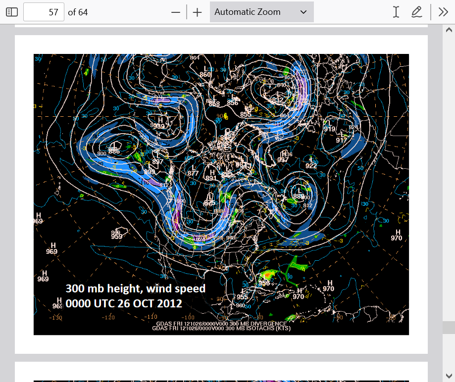
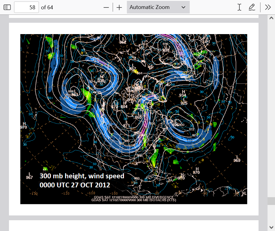
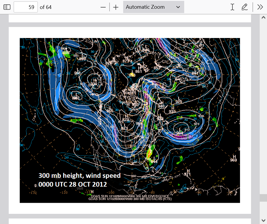
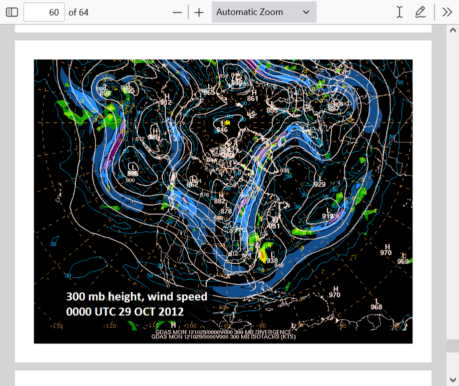
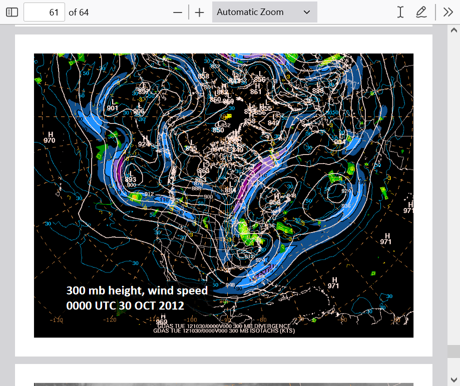
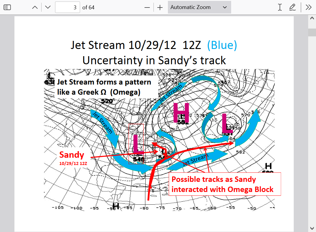
Here are the actual upper level/jet stream maps for the days leading up to the upper level low CAPTURING Sandy(entraining it into the upper low and them becoming 1 entity/storm), instead of steering it out into the Atlantic. Amazing!
A key element to this is the NEGATIVE TILT of the trough.
http://www.theweatherprediction.com/habyhints/127/
1. 300 mb, Oct 26, 2012
2. October 27, 2012
3. October 28, 2012
4. October 29, 2012
5. October 30, 2012 Frankenstorm Sandy
What role did global warming/climate change play in this?
Very little, if any. It was almost all natural variation.
+++++++++++++++++
It really boils down to this, once again(Cliff Mass can be counted on as an elite source for using objective, authentic science)
https://cliffmass.blogspot.com/2016/03/the-golden-rule-of-climate-extremes.html
The GoldenRule
Considering the substantial confusion in the media about this critical issue, let me provide the GOLDENRULE OF CLIMATE EXTREMES. Here it is:
The more extreme a climate or weather record is, the greater the contribution of natural variability.
Or to put it a different way, the larger or more unusual an extreme, the higher proportion of the extreme is due to natural variability.
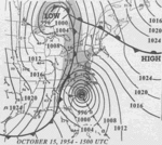
Was Superstorm Sandy unprecedented?
Actually, several hurricanes in the mid 1950's did a similar thing, especially in 1954.
Hurricane Hazel is a storm that I've used here several times to show this same dynamic happening previously.
1954 Hurricane Season
https://en.wikipedia.org/wiki/1954_Atlantic_hurricane_season
In the span of two weeks, hurricanes Carol and Edna followed similar paths before both striking New England as major hurricanes.[nb 2] The latter became the costliest hurricane in Maine's history.

Hurricane Hazel
+++++++++++++++++++++
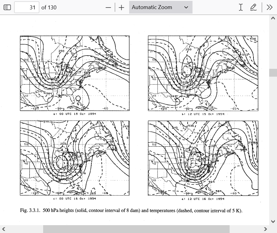
Note below, at this link of the 500 mb upper level charts, the striking similarity to the upper levels that entrained Sandy into its circulation that existed for Hazel to do the same thing.
https://central.bac-lac.gc.ca/.item?id=TC-QMM-80894&op=pdf&app=Library&oclc_number=899247730
Upper levels below for Oct 15/16, 1954 as they picked up Hazel.
++++++++++++++++++++
Upper levels below on Oct 29, 2012 as they picked up Sandy.
https://www.marketforum.com/forum/topic/98751/#98753
Same thing below for Oct 29, 2012 from another source:
https://www.marketforum.com/forum/topic/98751/#98754

Same dynamics at play for both Hazel (which was STRONGER than Sandy) and a few other storms that did the same thing as Superstorm Sandy. This was clearly not caused by global warming/climate change because the 1950's were part of a period that everybody agrees featured GLOBAL COOLING!
Could Hurricane Lee do the same thing?
I tried to pick out the most extreme, outlier operational models that would be closest to creating dynamics which would
1. Amplify the upper trough enough, especially to the south
2. Be far enough west
In order to be in the ballpark of having a chance of producing another Hazel or Sandy. They all still fall short but there's more than a week to go.
12z operational Canadian model below
12z operational GFS below
Previous run of the 0z operational European model below
Great and fascinating stuff, Mike! This got me to ask at American whether or not folks there think that the omega block associated with Sandy could be an analog to consider for Lee and future Margot (Invest 96L). After all, the models are forecasting a ridge to the NE of Lee and NW of future Margot.
I knew you would like this discussion, Larry!
You actually helped with your post earlier about the chances of Lee hitting the East Coast increasing a bit and it made me think about the pattern with Sandy and Hazel that caused them to track the way they did.
I forgot to mention that the key to the upper level trough capturing the remnants of Sandy was it being a negatively tilted trough.
This could NOT have happened if the trough was positively tilted, like most troughs are.
https://www.marketforum.com/forum/topic/98751/#98754
If you want more weather principles, forecasting rules and interesting stuff, this guy has it all.
Negatively tilted trough was #127 out of his #360 terms that he clearly defines, illustrates and applies to meteorology!
| HABY'S WEATHER FORECASTING HINTS |
