
The risk for Indiana is Tuesday night/Wednesday.
Added Tuesday: Changes in the way the system is developing have resulted in Wednesday getting taken out for Evansville but Thursday being added. It’s actually a NEW system.
The amount of risk is NOT very high for violent tornadoes! The jet stream is too weak!
Severe Storm Risk......updated daily(days 1 and 2 twice daily).
https://www.spc.noaa.gov/products/outlook/
Current Day 1 Outlook | |
Current Day 2 Outlook | |
Current Day 3 Outlook | |
Current Day 4-8 Outlook |
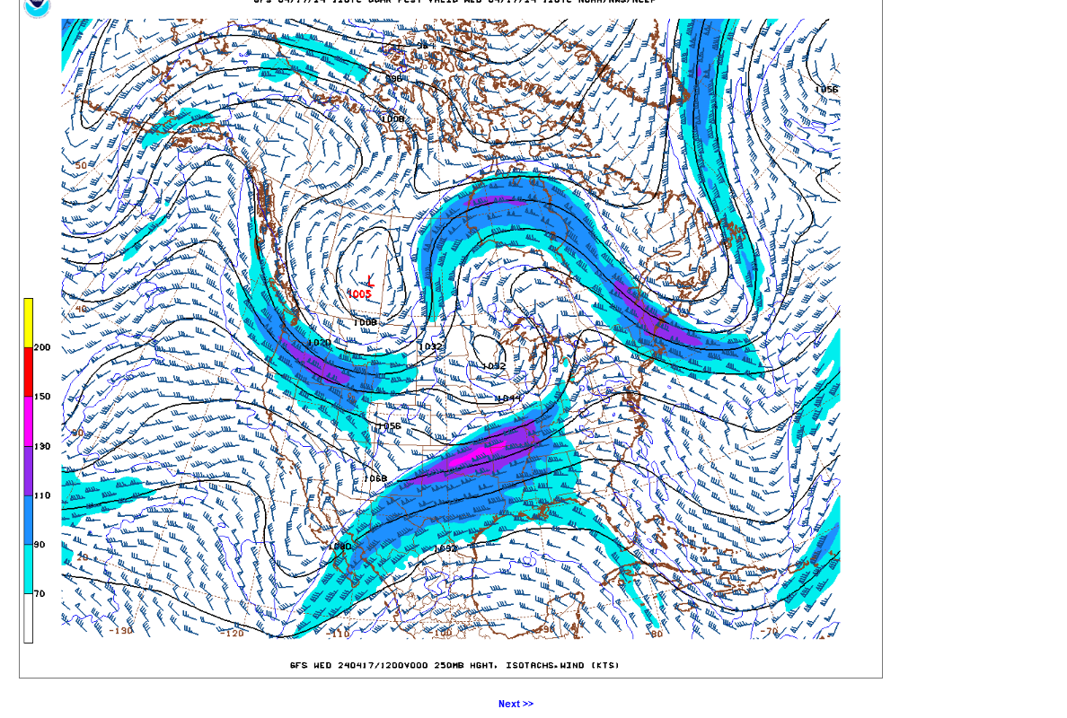
This is the 250 mb jet stream forecast for Midnight Tuesday Night from the last 12z GFS model
The narrow pink in the center is a 130 knot/hour jet streak. This is almost 150 mph. This will cause lift and spin in the atmosphere below it.
The jet stream is one of the best indicators for predicting the magnitude of a severe weather Event.
In the last 2 months, here in Indiana, we had 2 powerful systems that caused an outbreak of severe weather.
Let's compare this jet stream above to the last 2 OUTBREAKS.
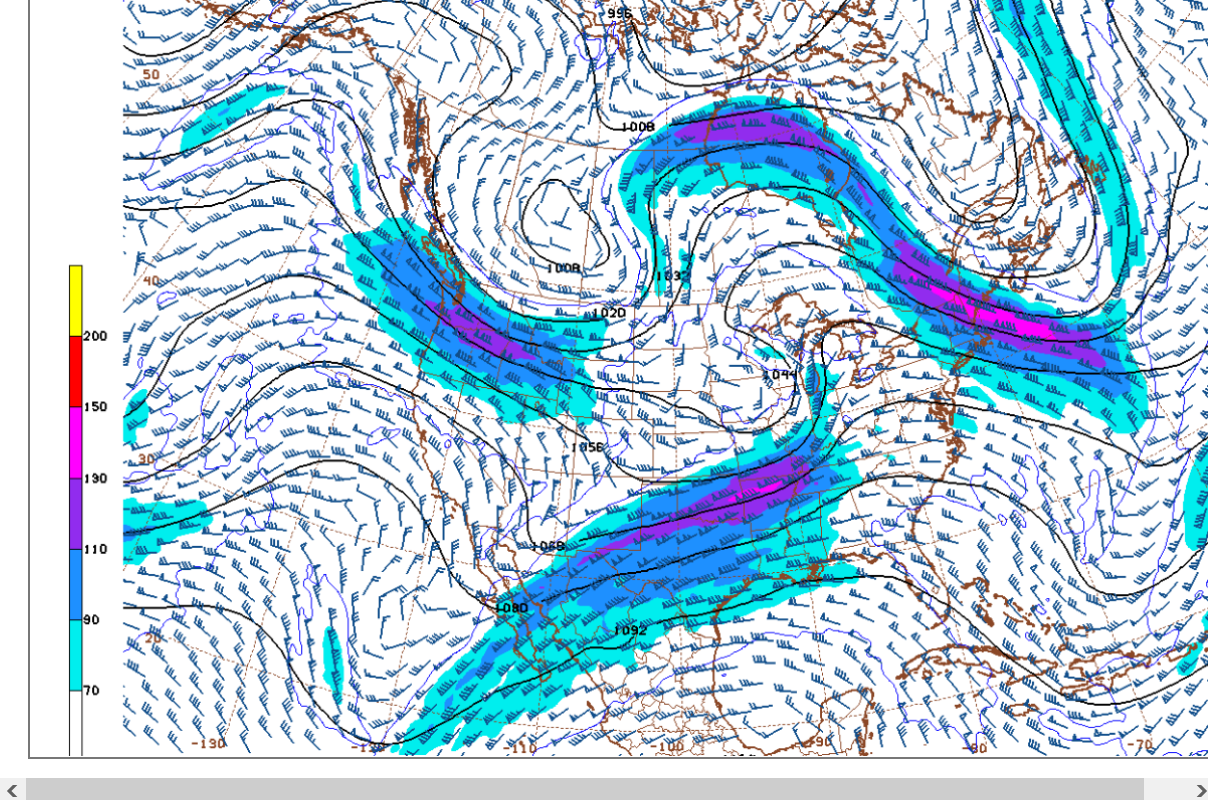
Jet stream April 1. 2024
https://www.marketforum.com/forum/topic/102905/#102906
Jet stream February 28, 2024:
https://www.marketforum.com/forum/topic/102510/#102521
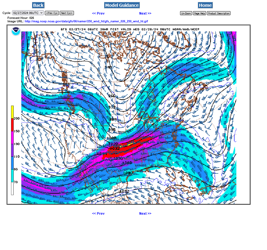
While this weeks jet stream is moderately strong, it's nothing like the very powerful jet streams during the 2 previous outbreaks.
This LESS favorable ingredient reduces the risk of the most intense tornadoes. However, since its later in the Spring, we have more heat/humidity available that will definitely contribute to a more unstable air mass with more lift, so the ingredients to grow thunderstorms will be more abundant.
AS the season progresses, heat and humidity continue to increase as jet streams continue to weaken(with the colder air receding northward and moderating).
With time, heading into Summer the incidence of non severe thunderstorms goes up and the incidence of violent tornadoes goes WAY down.
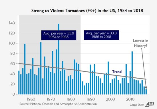
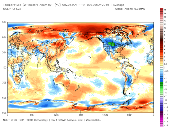
This is normal, expected weather in the United States at this time of year and has nothing to do with climate change. In fact, climate change has DECREASED the number of violent tornadoes by reducing the meridional(north to south) temperature gradient by warming the coldest places in the higher latitudes the most.
This is a very expected benefit from climate change based on meteorology 101, that never makes the sensationalized headlines. The data solidly confirms it too.
May 29th, 2019 by Roy W. Spencer, Ph. D.
https://www.drroyspencer.com/2019/05/recent-tornadoes-are-due-to-unusually-cold-weather/
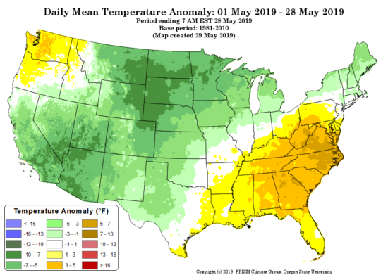
dr. Spencer: In fact, in terms of departures from normal, so far this year the Northern Plains has been the “coldest place on Earth”, averaging 5-10 deg. F below normal:
Not much has changed regarding this week's outlook for severe weather compared to 2 days ago.
However, the event will be starting today and we can start tracking it:
To see rain amounts, go here: https://www.iweathernet.com/total-rainfall-map-24-hours-to-72-hours
You can scroll down and get almost the entire comprehensive weather picture updated constantly here.
Current Hazards at the link below.
Go to the link below, hit hazards box in the top right hand corner(it will also define all the color codes), if its not already in the hazards mode when you load the link.
Then you can hit any spot on the map, including where you live and it will go to that NWS with all the comprehensive local weather information for that/your county.

New radar product below
Go to: "Select View" then "Local Radar"
Hit the purple circle to see that local radar site
+++++++++++++++++++++++
This link below provides some great data. After going to the link, hit "Mesoanalysis" then, the center of any box for the area that you want, then go to observation on the far left, then surface observations to get constantly updated surface observations or hit another of the dozens of choices.
 |
Current temperatures:
https://thermastor.com/dew-point-and-weather-maps/

Current Conditions below updated every few minutes.
UPPER MIDWEST
https://www.spc.noaa.gov/exper/mesoanalysis/new/viewsector.php?sector=13#


https://www.spc.noaa.gov/exper/mesoanalysis/new/viewsector.php?sector=13#

LOWER MIDWEST
https://www.spc.noaa.gov/exper/mesoanalysis/new/viewsector.php?sector=20

https://www.spc.noaa.gov/exper/mesoanalysis/new/viewsector.php?sector=20#

https://www.spc.noaa.gov/exper/mesoanalysis/new/viewsector.php?sector=20# 
SOUTHCENTRAL
https://www.spc.noaa.gov/exper/mesoanalysis/new/viewsector.php?sector=15#
SOUTHEAST
https://www.spc.noaa.gov/exper/mesoanalysis/new/viewsector.php?sector=18#

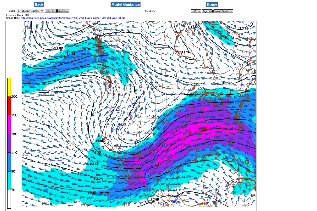
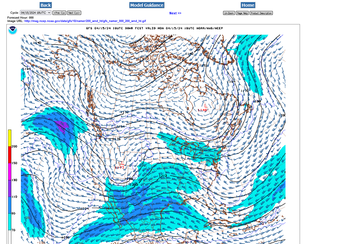
I went a bit higher in the atmosphere from 250mb to 200mb and found a stronger and STRENGTHENING jet stream there. This has me thinking the severe weather will increase tomorrow and Wednesday. The Storm Prediction Center will likely upgrade their forecasts tomorrow with some higher risk possible then.
1. Current jet stream-max winds ~120 mph
2. 5am Wednesday Jet stream-max winds ~160 mph
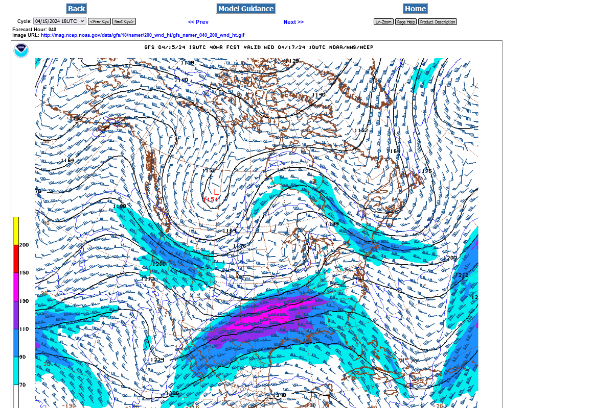
The severe storm risk will likely linger to the afternoon on Wednesday in Indiana!
As it turns out, the SLIGHT risk will wane on Wednesday but return on Thursday.
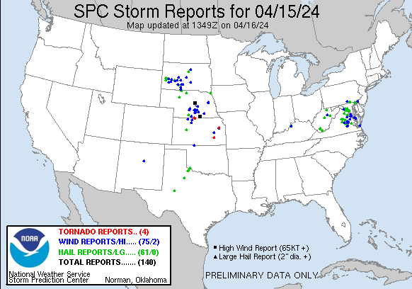
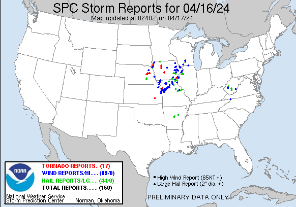
Storm reports from Monday/Monday NIght. Lack of a strong jet stream/upper level winds limited the tornadoes, which were all weak.
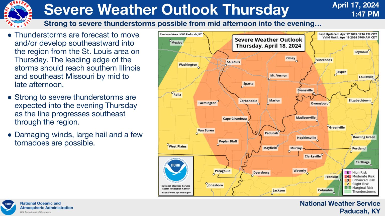
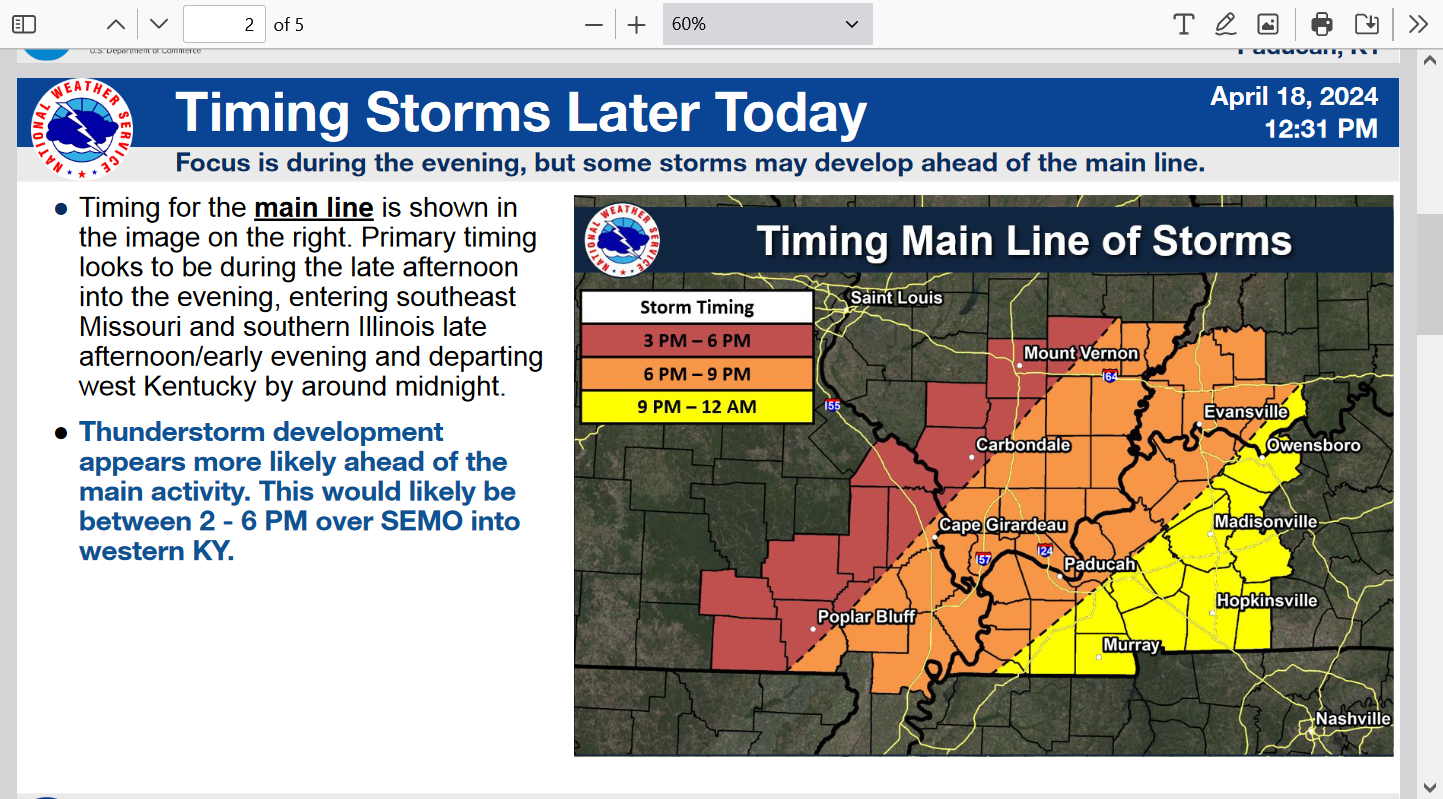
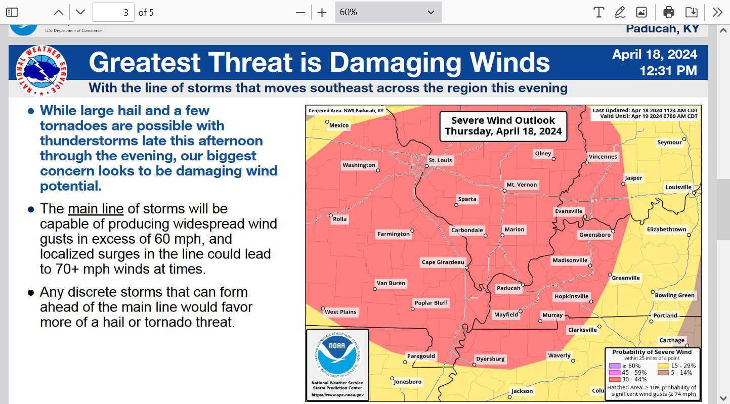
Here's the latest from the Evansville NWS:
https://www.weather.gov/pah/weatherstory
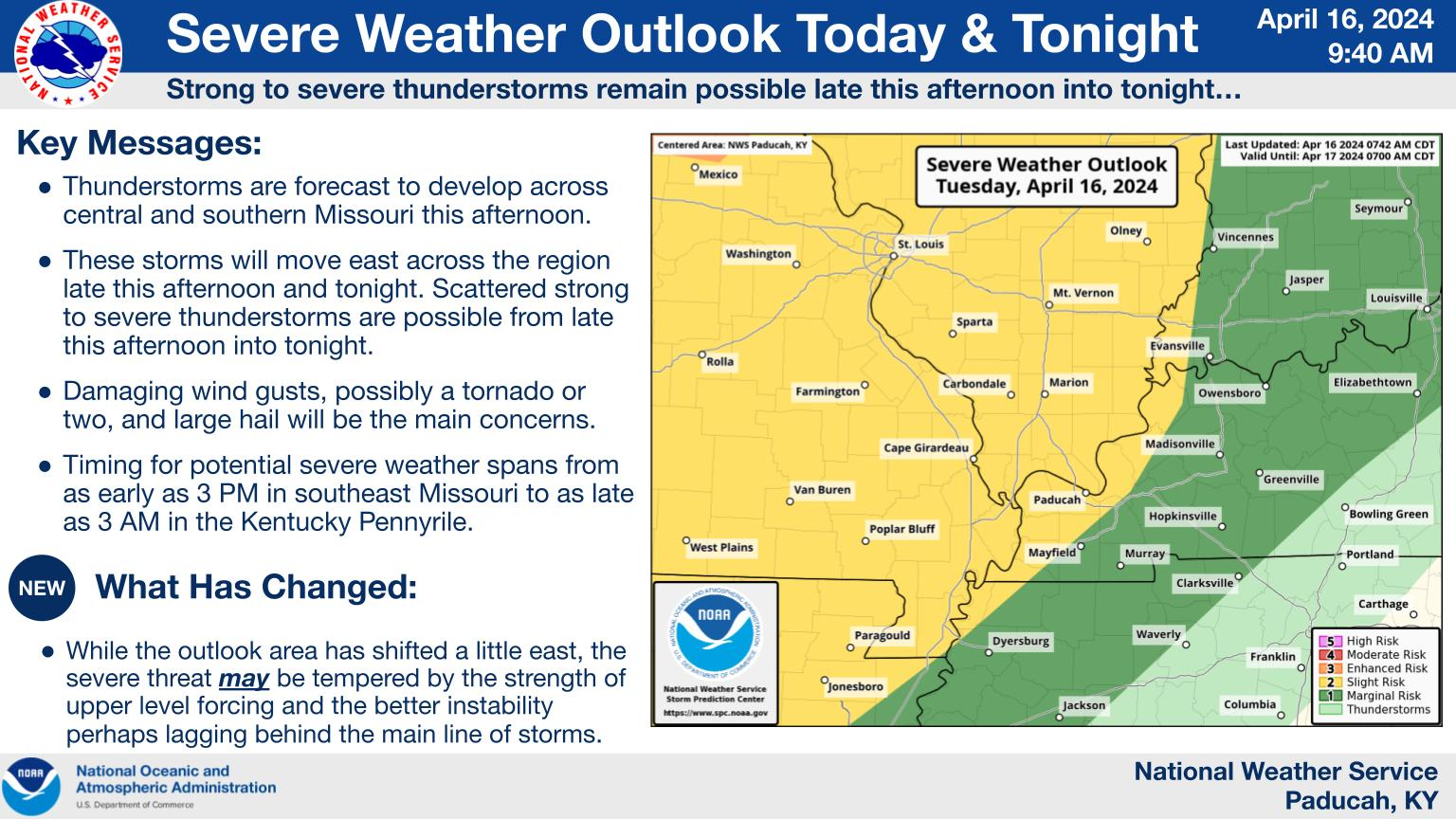
Noon Tuesday: They edged the yellow a bit east in this last outlook above that covers thru 7am Wednesday, which I agree with.
++++++++++++++++++
9pm Tuesday: The risk is out on Wednesday with a SLIGHT risk returning on Thursday.

There were numerous severe weather reports earlier today but things have calmed down a great deal this evening.
There's only a low threat with these, mostly weak thundershowers coming thru late this evening, other than something isolated and marginal with one particular cluster that will hit Evansville before 11pm
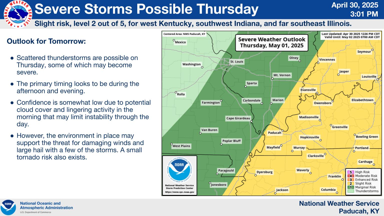
Carrying yesterday's forecast adjustments forward, Thursday now looks like prime time for the severe weather risk in Evansville. Even with that being the case, the risk is still SLIGHT!
And the reason is actually from a NEW jet stream. The OLD, southern branch of the jet stream is dying out and a NEW northern(Pacific) branch is creating the NEW upper level dynamics on Thursday:
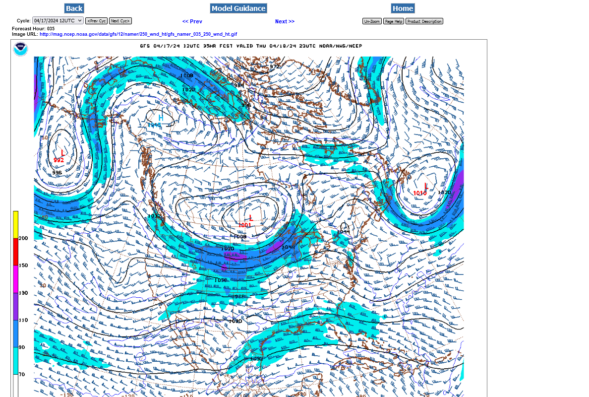
Current 250 mbJet streams from the just out 12z GFS on Wednesday morning. Southern branch dominates but with no surface features/fronts to focus on(that went thru last night). Look to the west, in the Rockies. Here comes the next system, racing towards us!
Late Thursday's 250 mb jet stream forecast below. The lift/dynamics from the northern branch of the jet stream will be INCREASING rapidly. The dynamics aren't all that great for a tornado outbreak or even violent tornadoes but yes for some severe thunderstorms and isolated tornadoes. ….in some places.
See the updated/adjusted severe weather risks at the top:
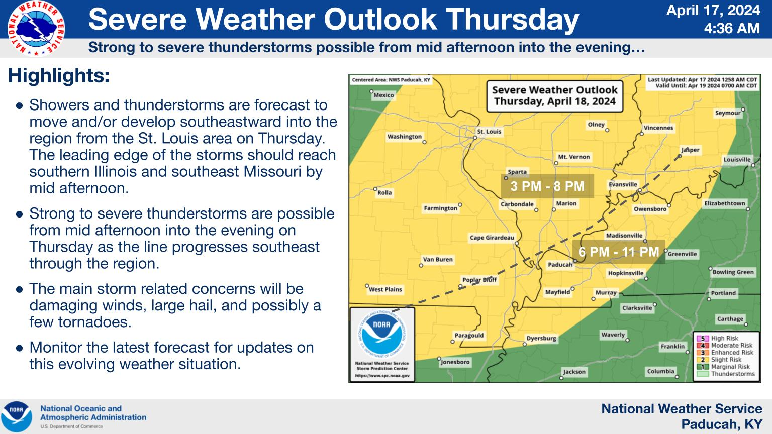
This does NOT look like a major tornado outbreak or one that supports violent tornadoes. It's the type of severe weather event where you should be safe inside of a permanent building and away from windows EVEN IF the worst storm in the area hits you.
The severe weather risk for Thursday has been upgraded to ENHANCED, level 3 for damaging straight line winds.
Severe Storm Risk......updated daily(days 1 and 2 twice daily).
https://www.spc.noaa.gov/products/outlook/
| Current Day 1 Outlook | |
| Current Day 2 Outlook |
++++++++++++++++++
Damaging wind risk-30% chance
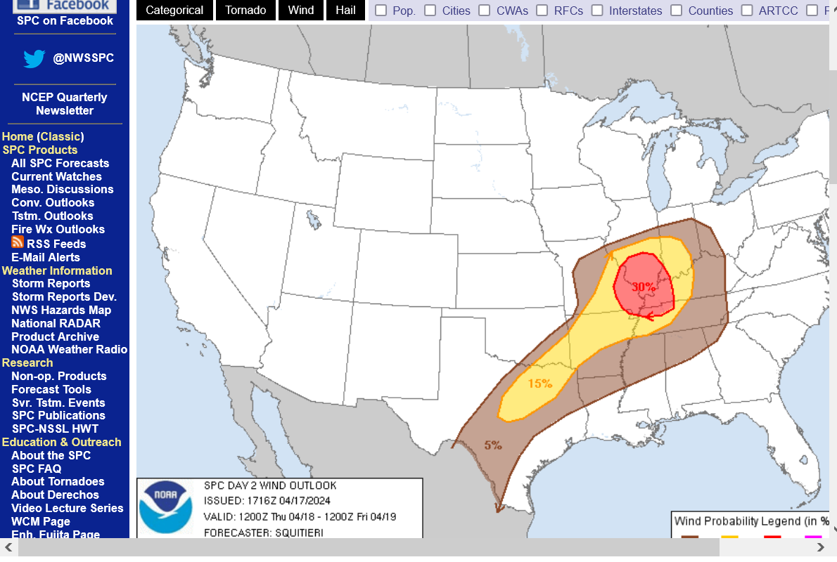
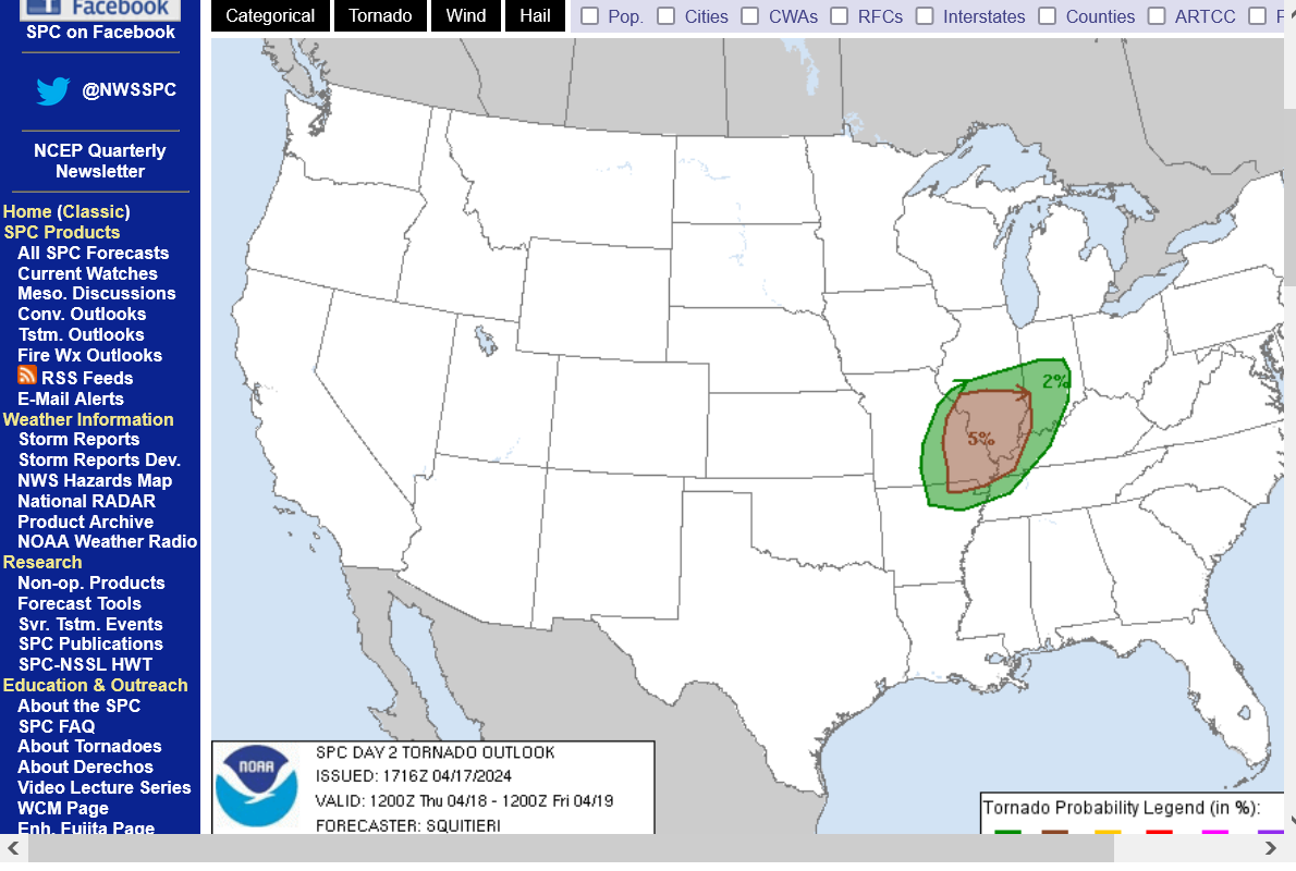
Tornado risk-can't be ruled out-5%
Hail risk-15%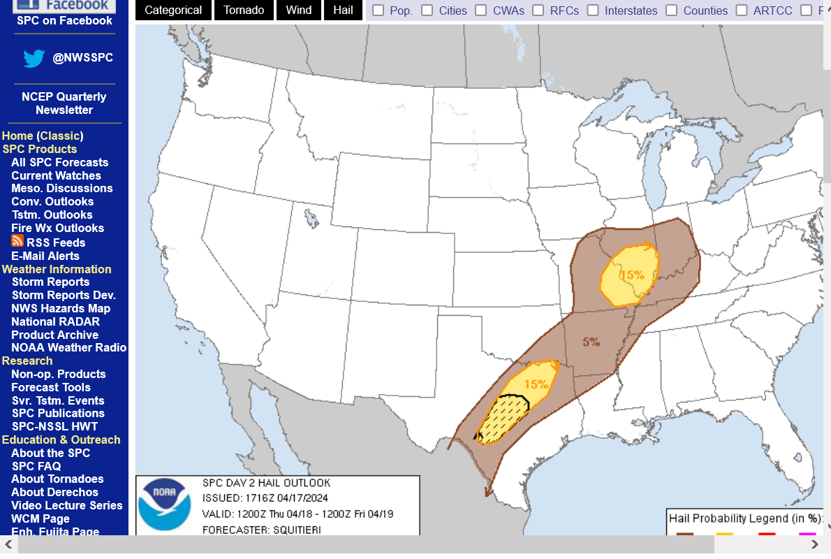
https://www.weather.gov/pah/weatherstory
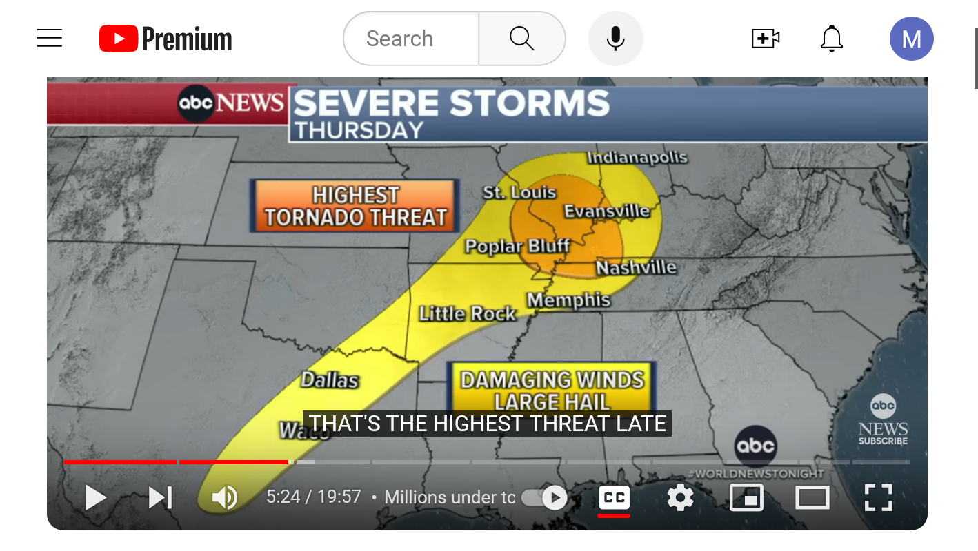
ABC Nightly news just broadcast a completely misleading, sensationalized and distorted map and statement about the risk of tornadoes in Evansville.
They took this map below and changed it for sensationalizing dishonesty. Instead of having the accurate labels of 2% and 5%, which are SLIGHT risk probabilities from the Storm Prediction Center, they made their own label HIGHEST RISK for tornadoes in the brown shade and their always sensationalizing meteorologist, Rob Exaggerationano claimed that Evansville IN would be having the highest risk for tornadoes tomorrow.
Reality check: This is what the NATIONAL media does all the time. Just read the previous posts here to understand the authentic facts for why there is just a slight risk for tornadoes.
Our local chief meteorologist at the same station, Wayne Hart-WEHT is the BEST I've seen in my life covering severe weather and that includes other stations in other states. #2 isn't even close to him....he's that good!
He actually replaced me as chief meteorologist in September 1993, which seems like a life time ago.
So this comment is only about ABC Nightly News.
A 5% chance of tornadoes is not insignificant, so I don't want to downplay it too much. Be prepared to go to your safe place and also know the upper level dynamics are not favorable for VIOLENT tornadoes that kill most people. Odds of one of those tomorrow are much less than 1%.........but NOT ZERO.
Also, the Storm Prediction Center will have updates the next 24 hours based on changes in the atmosphere. It's possible they could upgrade the tornado risk by 1 category to enhanced and upgrade the straight line wind risk to moderate.
The chance of them upgrading to a high risk for tornadoes on Thursday is near 0. We just don't have the right jet stream magnitude/velocity to cause deep layer shear!
https://www.spc.noaa.gov/products/outlook/day2otlk.html

Not much change in the forecast.
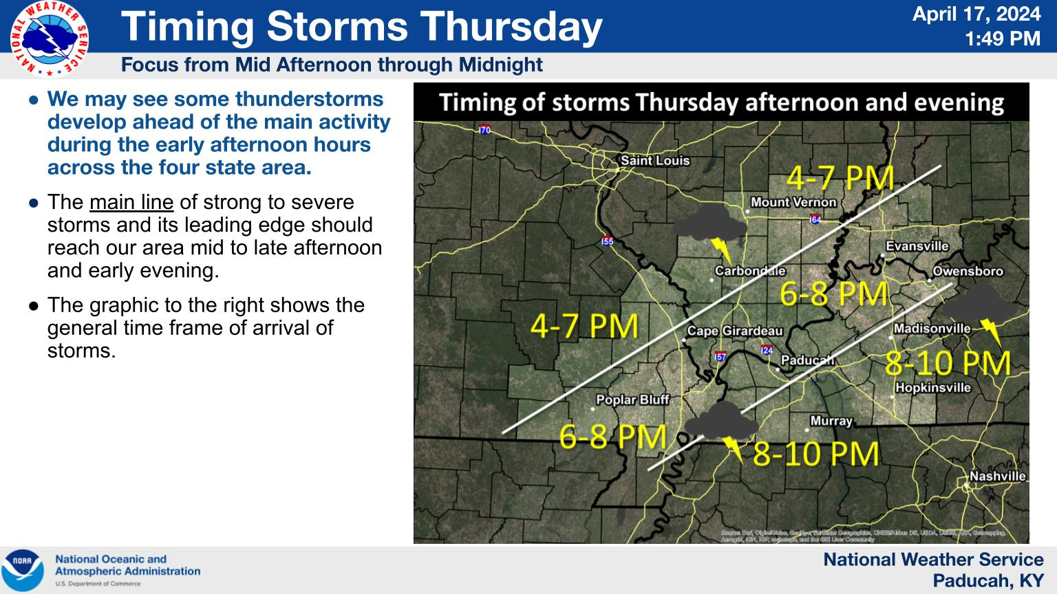
straight line severe thunderstorm winds are the main threat and prime time will be mid to late evening. The squall line along the cold front should become very well defined and easy to track and time this afternoon.
At 11am, you can barely make it out.
https://www.marketforum.com/forum/topic/103145/#103187
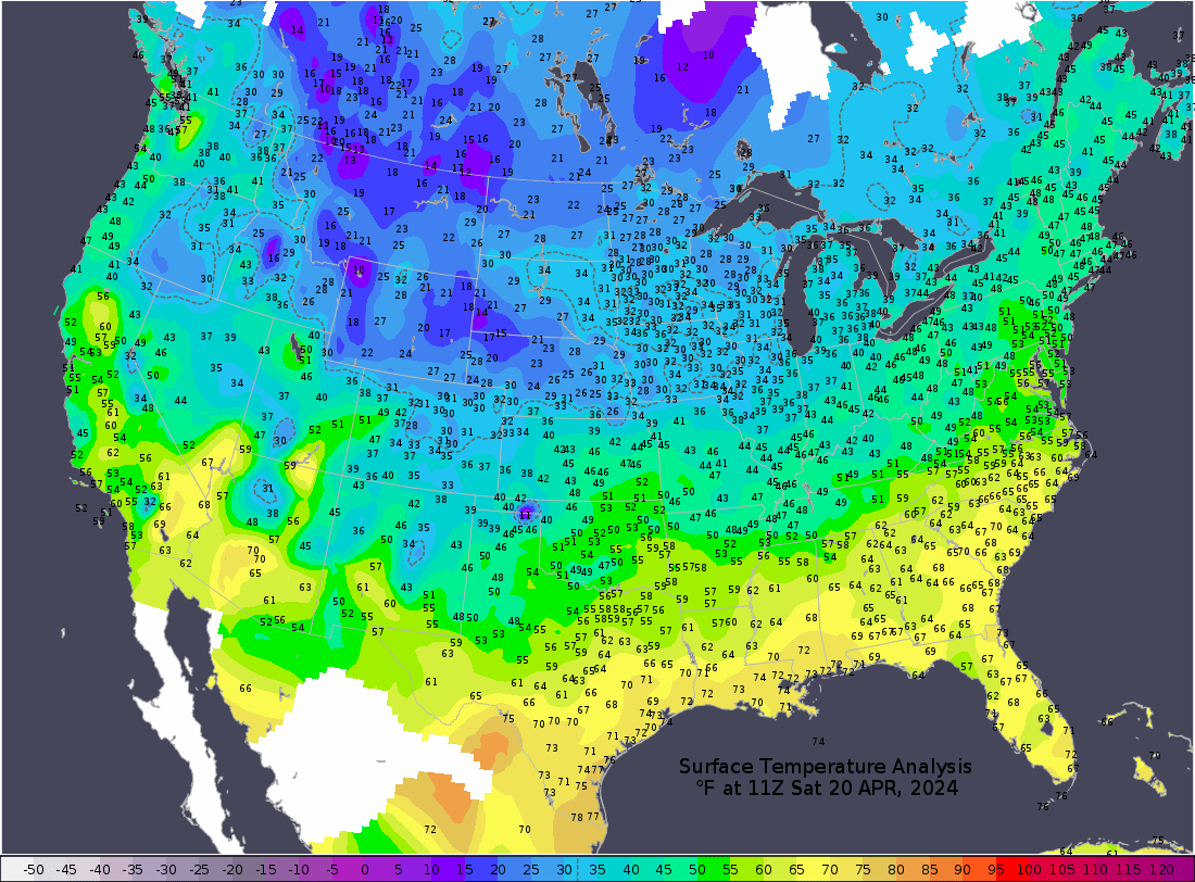
Look at the incredible contrast in air masses right now:
https://www.marketforum.com/forum/topic/103145/#103188
https://www.spc.noaa.gov/exper/mesoanalysis/new/viewsector.php?sector=20#
++++++++

Just waiting for the fireworks when the cold front enters the slight/enhanced risk areas, designated as such because of the instability and wind profiles in those shaded areas! The cold front is the TRIGGER that lifts the air to start the process!
Stable air that gets lifted, doesn't go very far/is suppressed. UNSTABLE air that gets lifted........results in a continuation of upward motion that leads to thunderstorms. Very unstable air, rapid intensification and even severe storms. A strong jet stream adds to this and also creates wind shear and spin. We DON'T have a strong jet stream.
The jet stream below for later today on the just out 12z GFS is not especially impressive.
So what we have are some strong ingredients near the surface with alot of instability as seen from the temperature/dew point and other profiles above which will be lifted into severe storms later today. But the upper level wind profile below is the factor which is only providing modest assistance and wind shear.
Violent tornado outbreaks will often have alot of pinks and reds and 200 mph winds with the jet stream. This time, we're more like 125 mph.
We could still have several tornadoes somewhere, maybe in Evansville(its possible) and a couple could be strong-outside chance of that but a widespread violent tornado outbreak is very unlikely with this jet stream below.
Note: I'm a weather forecaster/meteorologist. Weather forecasters are wrong for a living (-: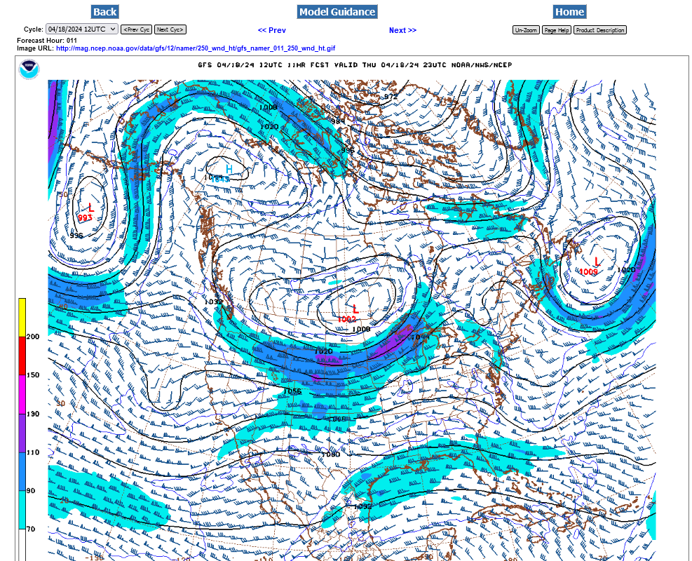
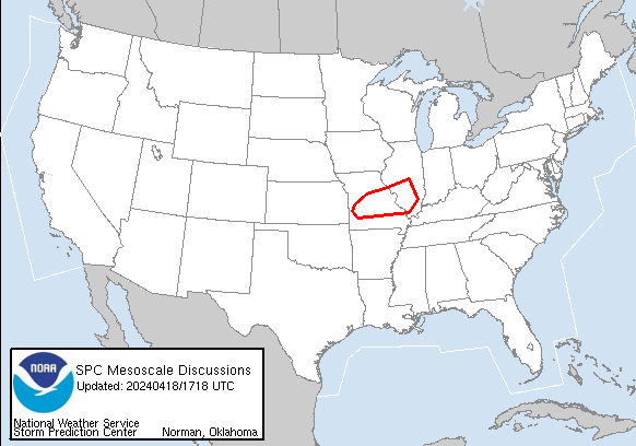
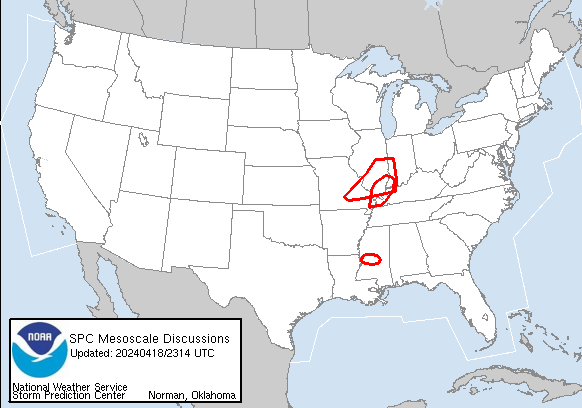
The Storm Prediction Center is getting ready to issue their first WATCH of the day in the next hour or 2. 80% chance they say.
https://www.spc.noaa.gov/products/md/
https://www.spc.noaa.gov/products/md/md0481.html
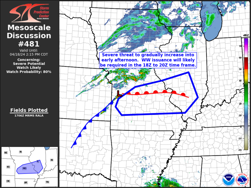
In their worded discussion, the Storm Prediction Center mentions the chance of a QLCS tornado. What's that?
Larry will like this:
https://www.weather.gov/lmk/squallbow
Quasi-Linear Convective System (QLCS).
Transient tornadoes also can occur in squall lines, especially in association with bow echoes. These tornadoes, however, tend to be weaker and shorter-lived on average than those associated with supercell thunderstorms.
+++++++++++++++++
This lines up with my previous thinking that upper level winds today are NOT favorable for violent or widespread tornadoes.
We got the SEVERE THUNDERSTORM Watch. Storms are developing AHEAD of the main line and some of those could quickly become severe with the very unstable air mass and lift.
Here's the latest from the Evansville NWS:
https://www.weather.gov/pah/weatherstory

ABC Nightly news yesterday, sensationalizing a LOW tornado threat for Evansville and unnecessarily scaring/alarming people. That's what the national media does for ratings. It's who they are!
The fact that the Storm Prediction Center is issuing Severe Thunderstorm Watches this afternoon and NOT Tornado Watches, speaks for itself.
https://www.youtube.com/watch?v=_60aJayUeEo
Described last night after it happened here:
https://www.marketforum.com/forum/topic/103145/#103262
We're losing more and more objective, professional journalism and replacing it with more and more "yellow journalism" that is especially so with weather and the fake climate crisis. The fake high tornado threat for Thursday is just one of thousands of examples. These people aren't dumb. They had to have known the real threat.
https://en.wikipedia.org/wiki/Yellow_journalism
Yellow journalism and yellow press are American terms for journalism and associated newspapers that present little or no legitimate, well-researched news while instead using eye-catching headlines for increased sales.[1][non-primary source needed] Techniques may include exaggerations of news events, scandal-mongering, or sensationalism.
+++++++++++
I was chief meteorologist for WEHT in Evansville, IN from 1982-1993. We lived or died by the ratings but in the current age of the internet, newspapers and the original broadcast television networks are getting killed and replaced from the massive increase in competition.
One way for them to compete has been for some of them to resort to "yellow journalism"
To repeat, the actual local news and weather at WEHT does not seem to be as impacted. In fact, their chief meteorologist, Wayne Hart (that replaced me) is the best that I've ever seen ahead of and especially during severe weather with his Doppler radar interpretations.
By "the best" I literally mean better than the thousands of others that I've seen in my 4+ decades of doing this during severe weather. Better than anybody at the Weather Channel or other tv stations.
When we have severe weather, besides what I can do here, I watch him. Nobody else.
Thanks for that $100 to plug you, Wayne (-:
Totally kidding. It's a rock solid fact.
Here's an example of the type of severe weather coverage that he gives us. The recording starts at the 1 minute point: https://www.facebook.com/eyewitnessnewslocal/videos/1140789323379633
This guy is unreal!
He's the Super Energizer Meteorologist on steroids!
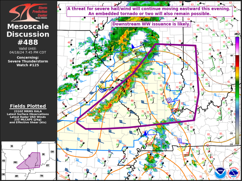
The Storm Prediction Center is getting ready to extend the watch box.
https://www.spc.noaa.gov/products/md/
Mesoscale Discussion 0488 NWS Storm Prediction Center Norman OK 0612 PM CDT Thu Apr 18 2024 Areas affected...Southeast MO into southern IL...extreme southwest IN...and western KY
We got the SEVERE THUNDERSTORM Watch. Severe Storms moving fast into our area.
I brought the local page down here for convenience.
If you refresh this current page it will show the latest radar loop and warnings below
https://www.marketforum.com/forum/topic/103145/#103300
Here's the latest from the Evansville NWS:
No tornadoes. That's why these have been SEVERE THUNDERSTORM Watches NOT TORNADO Watches.
storms are racing east/southeast at 55 mph.
should hit evansville around 9-20pm..
70 mph wind gusts are possible. No tornadoes but a weak one could spin up.
i have all of our electronics charged up in case of losing power.
If you refresh this page it will show the latest radar loop and warnings Above.
+++++++++++++++++++++++++
Evansville in the warning now and the storms have weakened a bit
60 mph wind risk Now before it was 70 mph
It's over for our area.
The data below is a freeze frame. As of 10:10pm:
49 large hail reports
42 high wind reports
0 tornadoes
Overall a minor severe weather event, mainly because the jet stream was not that powerful.
https://www.marketforum.com/forum/topic/103145/#103271
+++++++++++++++++++++++++
We're sending the weakening storms to mcfarm and cutworm! This is the Indianapolis radar, not updating version.
Storms shouldn't be too bad the rest of the night. It does not look like the Storm Prediction Center is going to issue any more watches during the rest of the night.
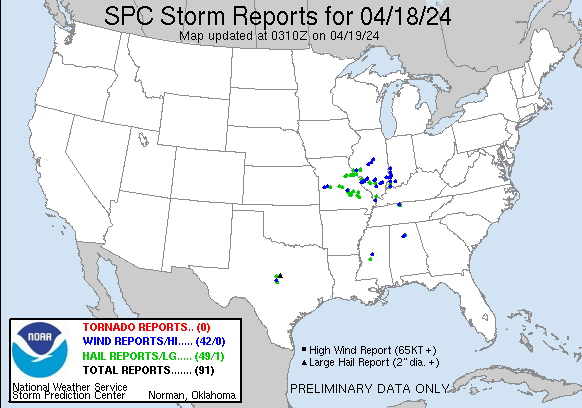
This is the tally for severe weather reports, yesterday/Thursday.
There was 1 tornado reported in the St.Louis area. There were numerous tornado warnings but those were all prompted by radar indicated circulations aloft that never reached the ground. NWS surveys of damage could still result in them deciding some of the damage was from a brief, weak tornado.
https://www.spc.noaa.gov/climo/reports/240418_rpts.gif

1. 1 weak tornado
2. 54 large hail
3. 82 high winds
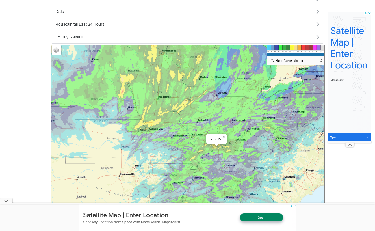
We got just over 2 inches of rain in our backyard rain gauge.
https://www.iweathernet.com/total-rainfall-map-24-hours-to-72-hours