Please Scroll down for the latest posts/updates!
Previous thread:
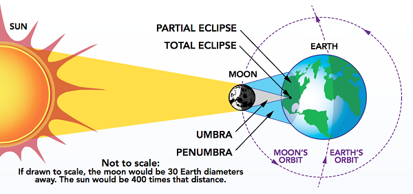
Great Solar Eclipse 4-8-2024
19 responses |
Started by metmike - April 15, 2023, 10:09 a.m.
https://www.marketforum.com/forum/topic/94555/


+++++++++++++
We're in the countdown and can now forecast the cloud cover/skies with decent accuracy!
The best article about weather on Monday, April 8, 2024. Longtime readers here know how much respect that I have for Cliff Mass-the best in the business!
https://cliffmass.blogspot.com/2024/04/the-subtropical-jetsteam-versus-total.html
https://wattsupwiththat.com/2024/04/04/the-subtropical-jetstream-versus-the-total-eclipse/
++++++++++++
His outlook is not that optimistic.
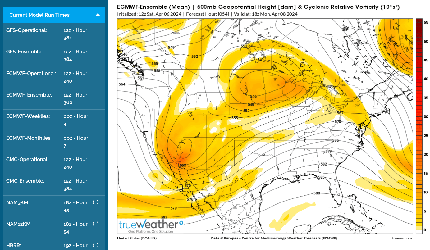
The vorticity map below, shows "spokes" of vorticity in the flow.
It will change in detail the next 3 days but a spoke has passed to our northeast at 2pm Monday, which would be favorable for skies to clear behind that yellow patch in Indiana, northeast of Evansville Indiana.
More when I get back from McCutchanville chess practice but I‘m pretty bullish for favorable eclipse viewing weather.
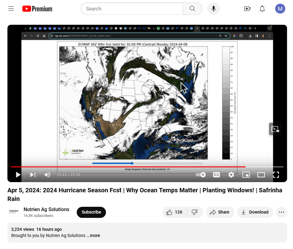
Eric Snodgrass's cloud forecast for Monday's eclipse using the European model. Mostly cloudy.
However, I'm MUCH more optimistic and so is the NWS!
NWS Evansville:
https://forecast.weather.gov/MapClick.php?x=284&y=83&site=pah&zmx=&zmy=&map_x=284&map_y=83

NWS Artificial Intelligence numerical forecast:
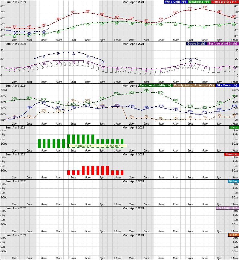
22% sky cover at 2pm on April 8, 2024 at Evansville, IN. Note the blue line/numbers below.
++++++++++++++++++++++
Everything you need to know to safely see the 2024 total eclipse on April 8.
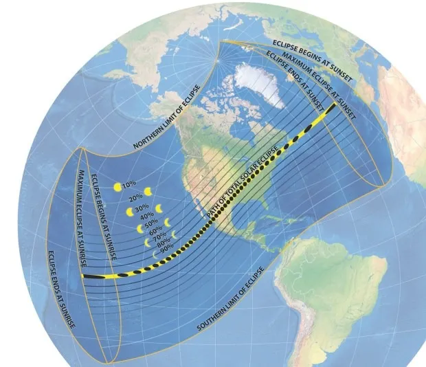
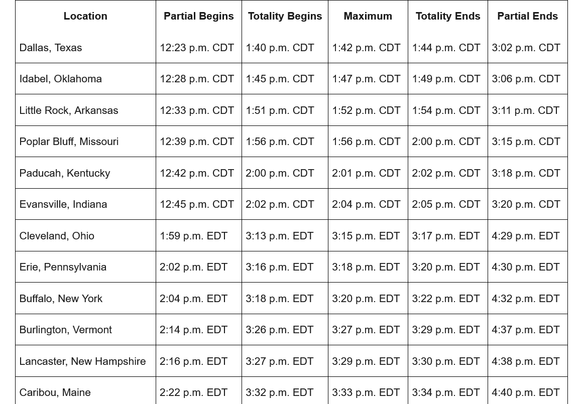
What time is the 2024 eclipse? The time the eclipse occurs at any place varies across the U.S. We also have to take into account the change in time zones from Central to Eastern. This table shows the times for a dozen cities that will experience totality.
The amount of sunshine won't be known with high confidence until early Monday at the earliest, possibly not until hours before showtime!
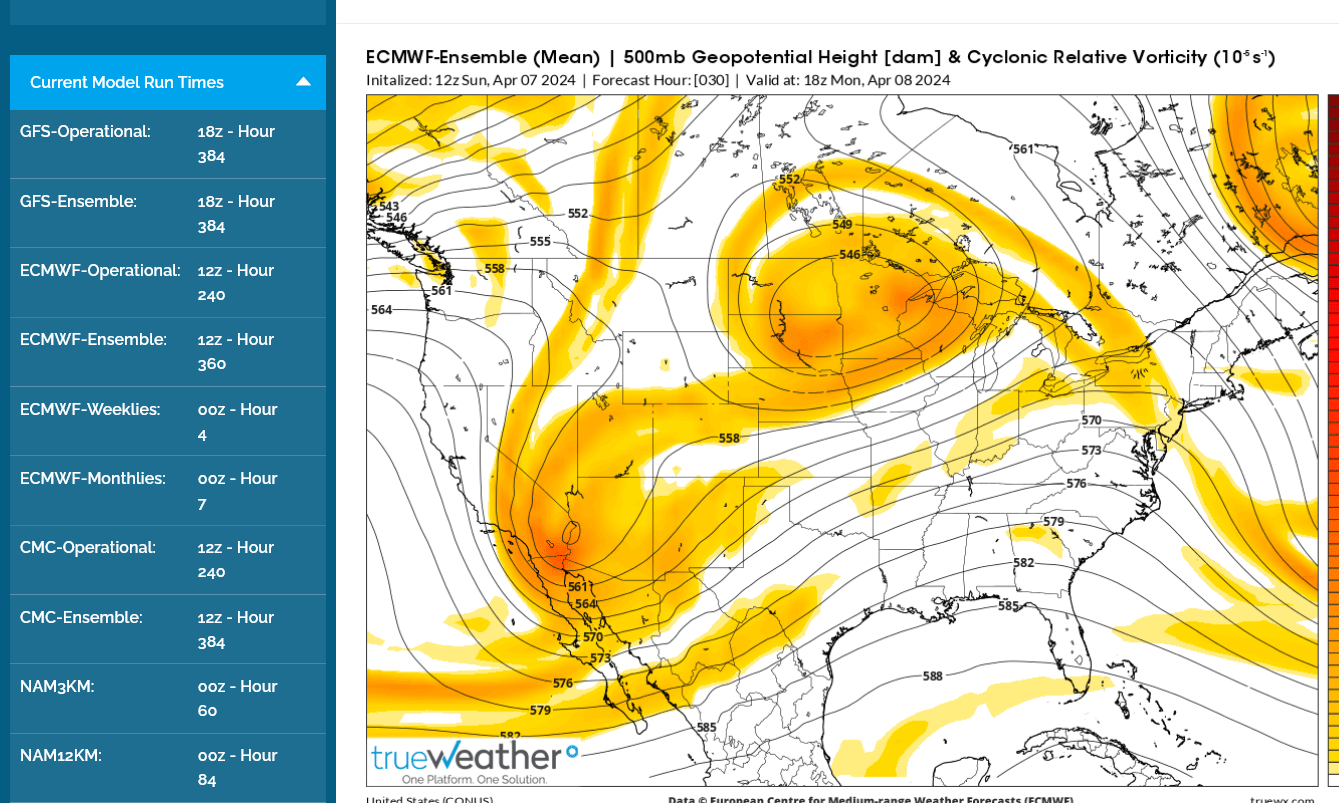
Southwest Indiana is in between lobes of vorticity in the southwest upper level flow but that's using the European Ensemble model forecast below. Models are not always correct.
That's just 1 favorable factor related to mid/upper level dynamics/rising air.
AT the lower levels strong warm air advection could bring in enough moisture for low level clouds.
With a stiff breeze, warming temps and slightly negative vorticity any low clouds SHOULD burn off by late morning. Should is the operative word.
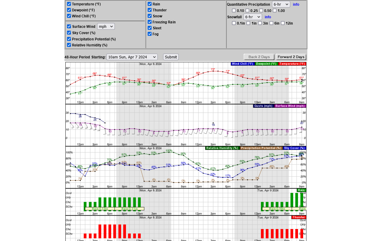
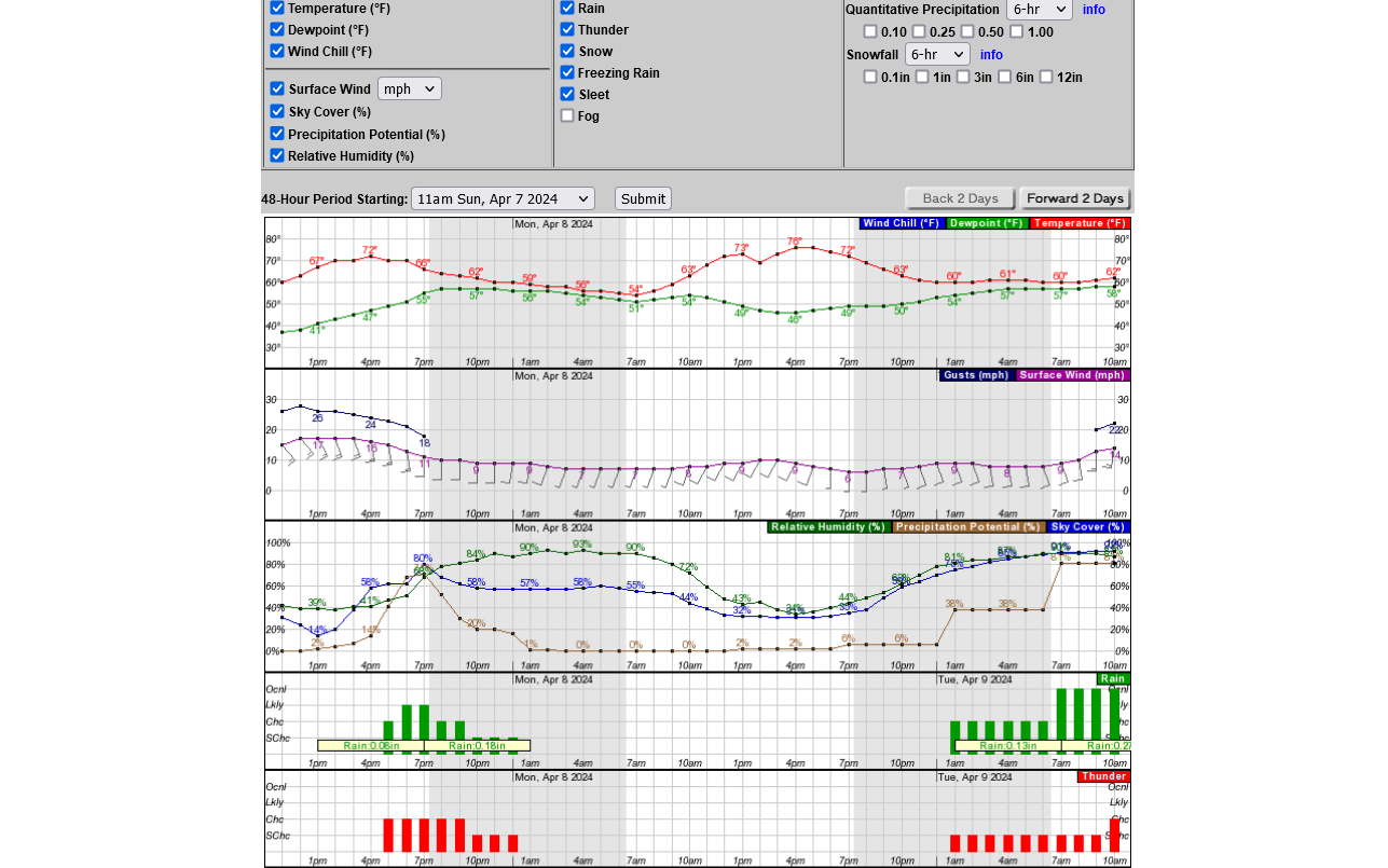
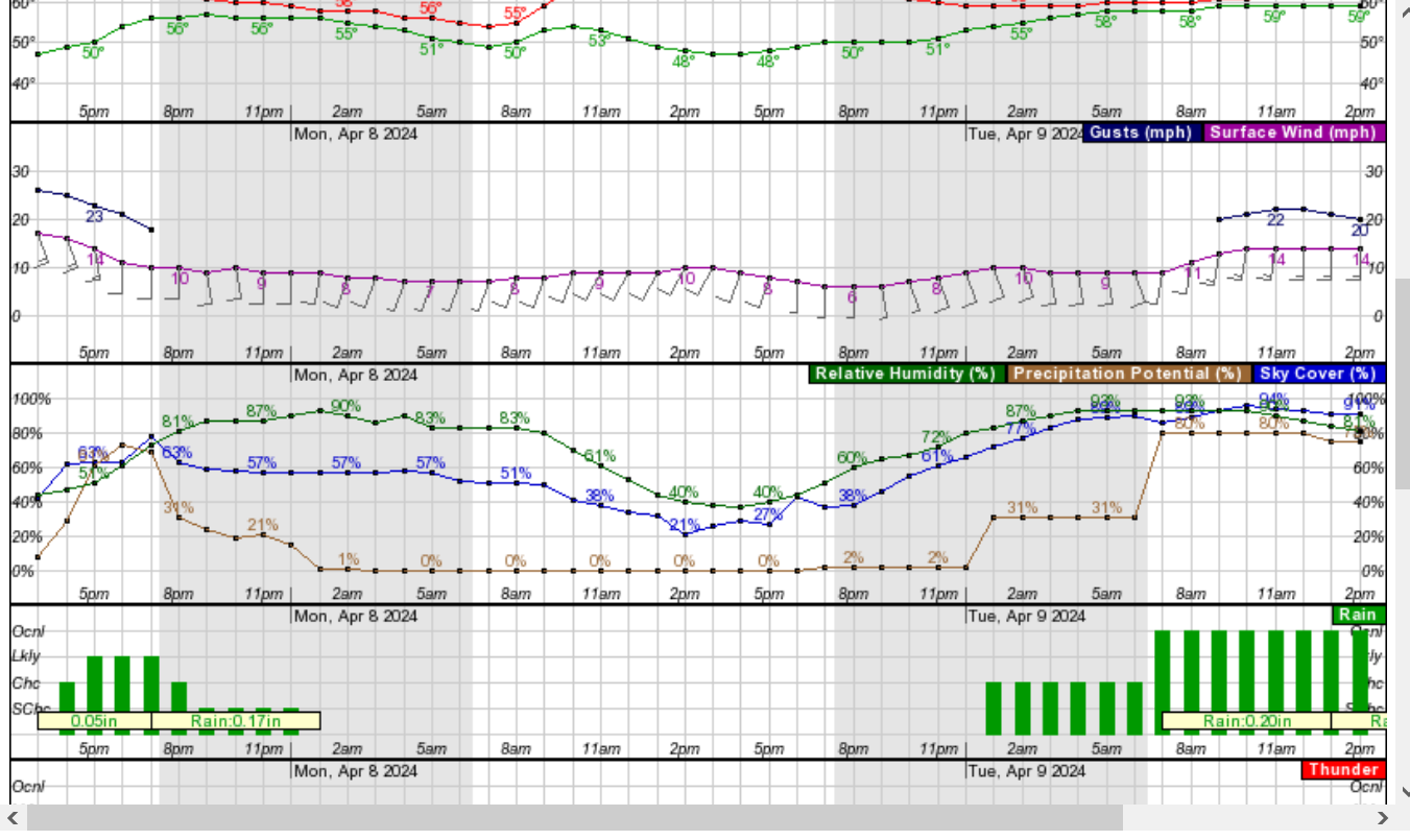
This is the AI, NWS hourly, numerical weather graph for all elements of weather.
Cloud cover in blue below, falls from 60% at 10am to below 30% just after 1pm(just in time for the eclipse) and continues to drop all afternoon to 17% by 6pm.
This has been a consistent positive for several days now. However, it's the type of forecast based on some marginal elements that can bust badly if clouds stick around a few hours longer than expected.
On any other day.........it doesn't matter much!
On THIS day. It's everything!
Still looks pretty good for Monday afternoon but a close call!
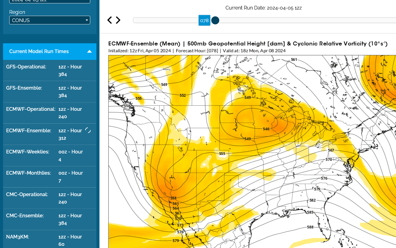
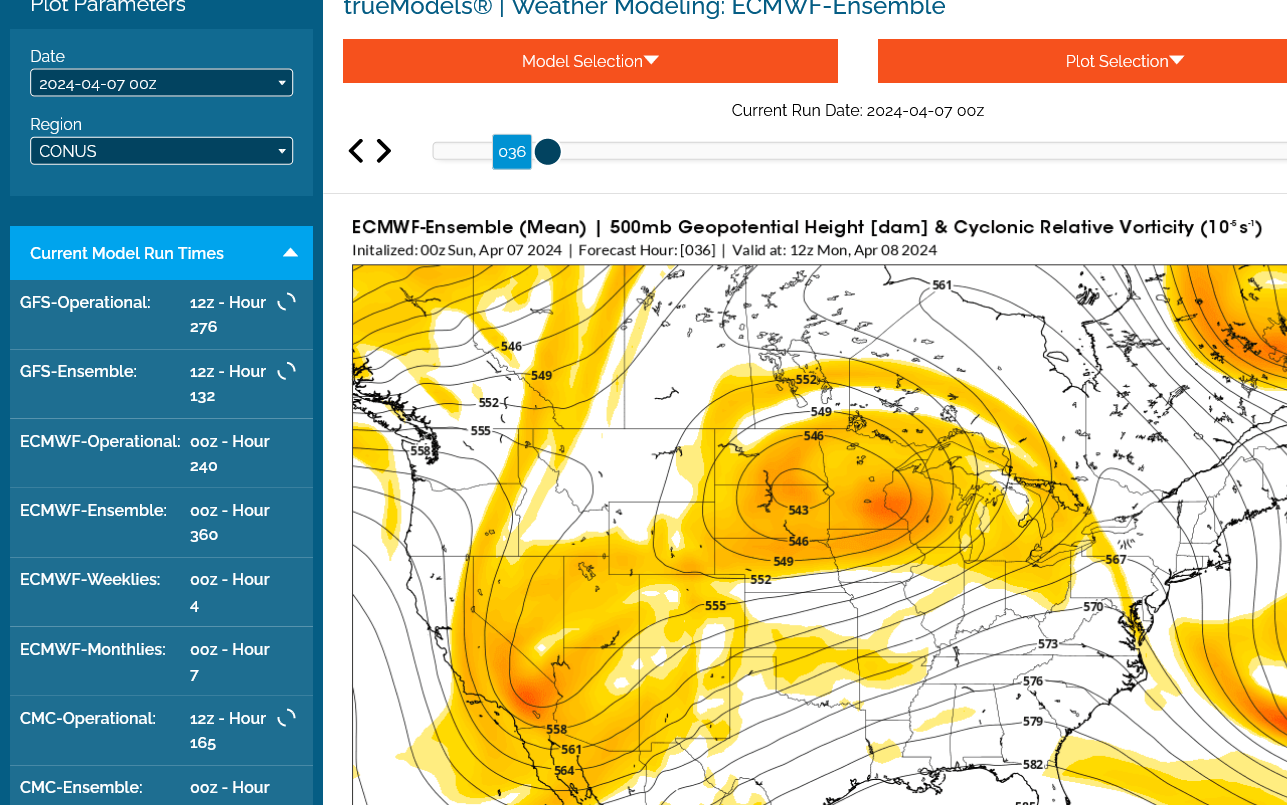
I'll show you why with 3 vorticity maps below from the last 0z European model Ensemble(best model).
1. 7am-big lobe of vorticity in the southwest flow, aimed at Indiana. This is favorable for rising air and potentially SOME clouds. Some very modest cyclonic flow.
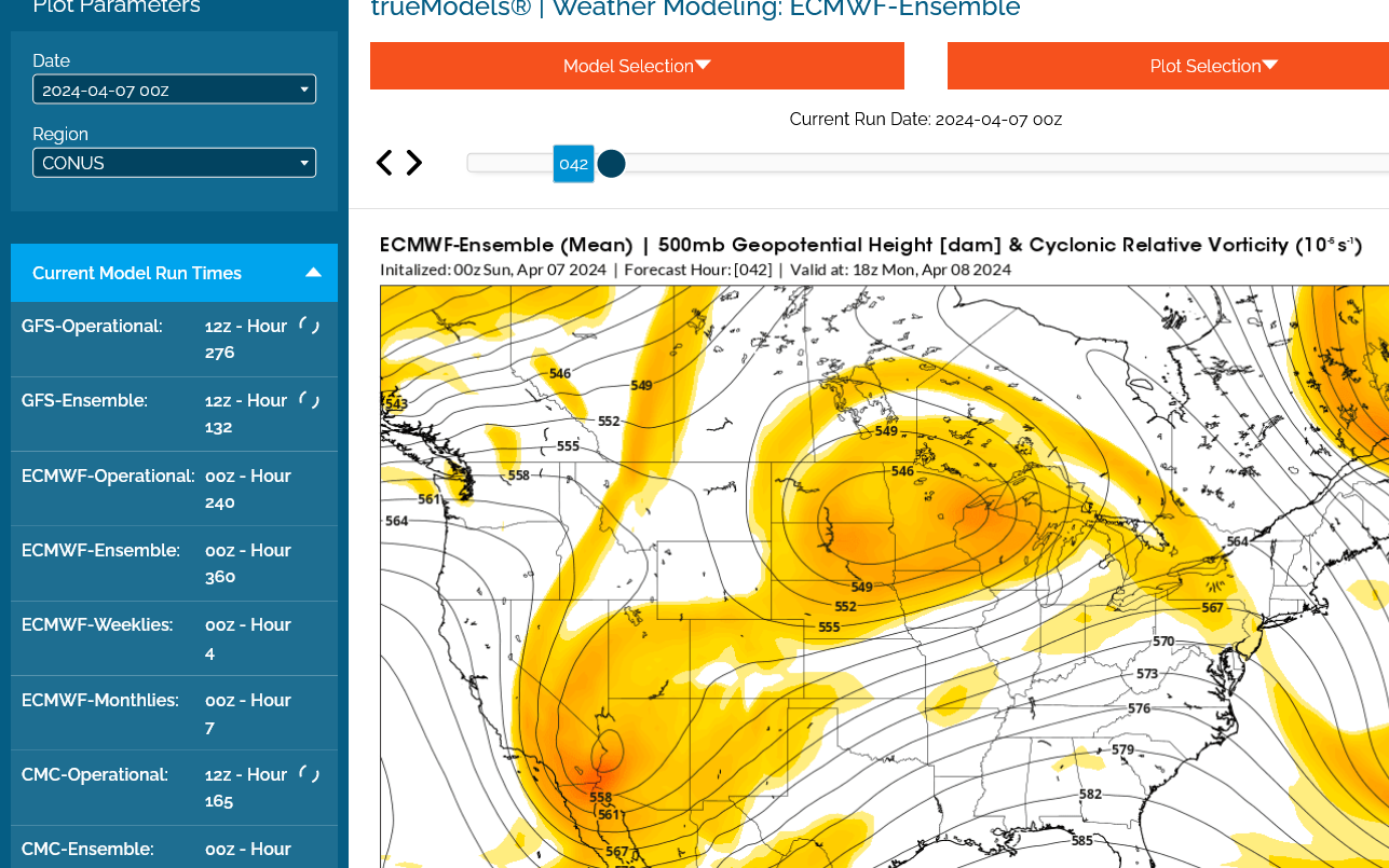
2. 1pm- that vorticity lobe has weakened/broken up with Evansville in very slight negative vorticity, in the middle of slightly positive vorticity. Flow is becoming slightly more ANTI cyclonic which favors descending air and less clouds.
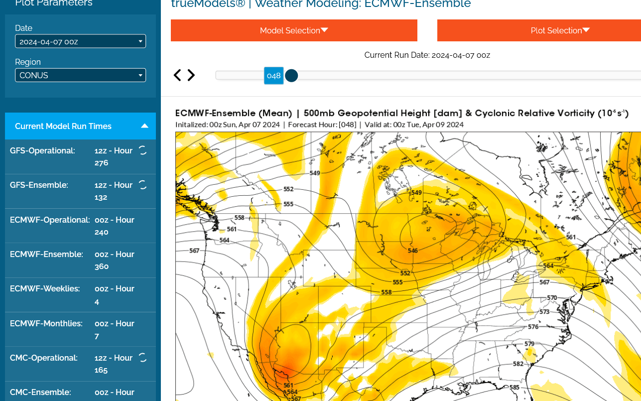
3. 7pm- that trend continues with upper levels. LESS clouds late in the day than early in the day likely.
The NWS AI below is at 32% clouds at eclipse time. Slightly higher than the last 3 days:
What would the weather/climate be like on our planet without a moon?
You may be shocked to find out! That's coming up.
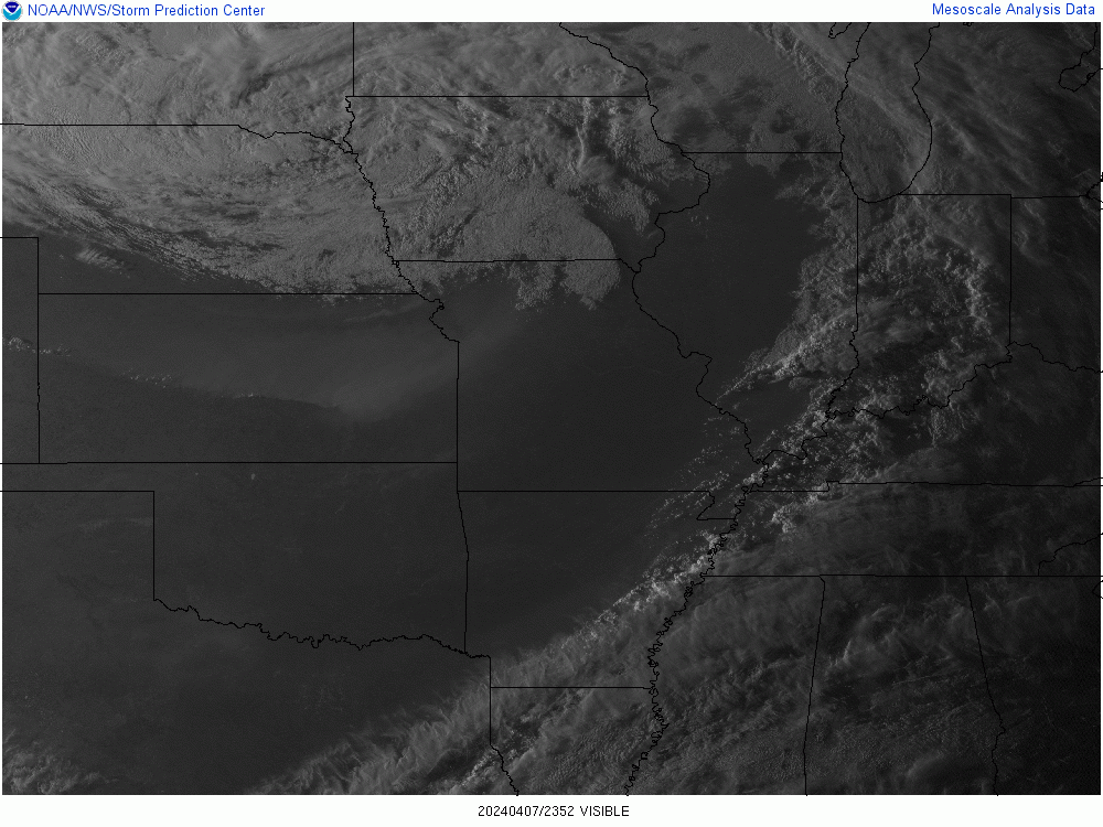
Time to start tracking the clouds now that we are around 24 hours to go:
We need that huge cloud band in MO/AR to pass thru by 1pm tomorrow. That's what it all boils down to right now!!! Doesn't matter what weather models or the NWS forecasts say. Monitoring these clouds gets ALMOST ALL THE WEIGHTING the next 24 hours!!
In addition, there is another cloud deck coming from the southwest that is a bigger threat(that SHOULD barely stay south). More analysis to come.
Noon-April 7th
1pm-April 7th
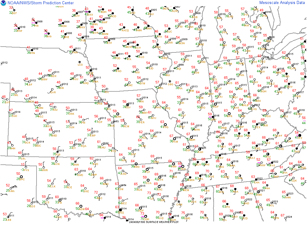
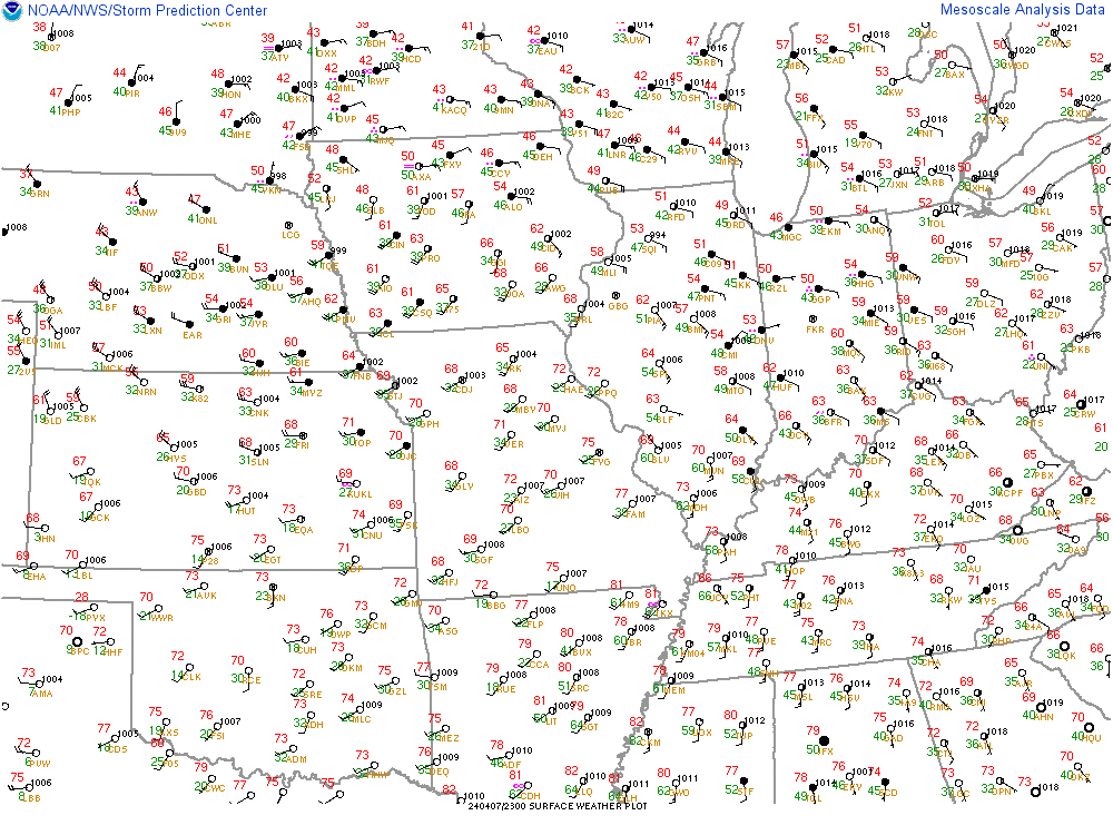
Surface reports below confirm that on the other side of those clouds, skies are CLEAR/SUNNY in western AR and most of MO. I have moderate to high confidence that that this cloud deck will be thru Evansville on Monday afternoon!!!
There are questions about the movement and timing that can't be answered without tracking it for several hours this afternoon. Stay tuned!
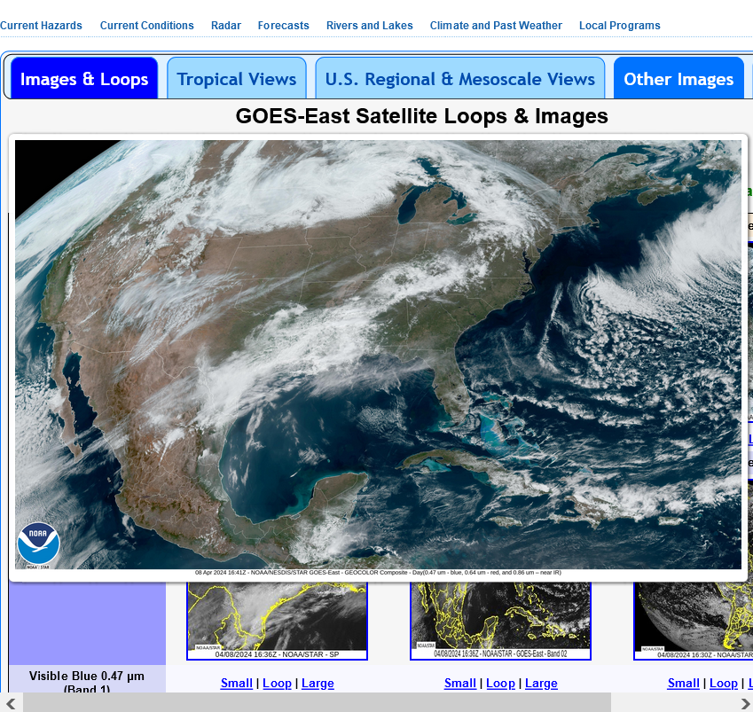
Great Satellite loop site:
https://www.star.nesdis.noaa.gov/GOES/conus_band.php?sat=G16&band=GEOCOLOR&length=48
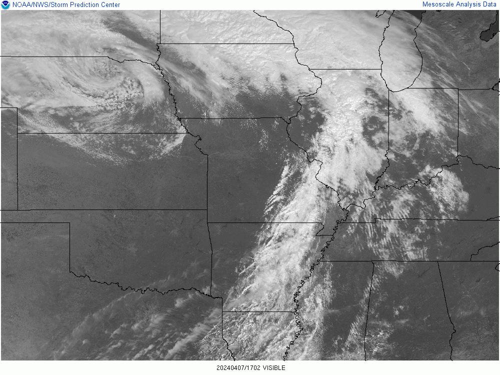
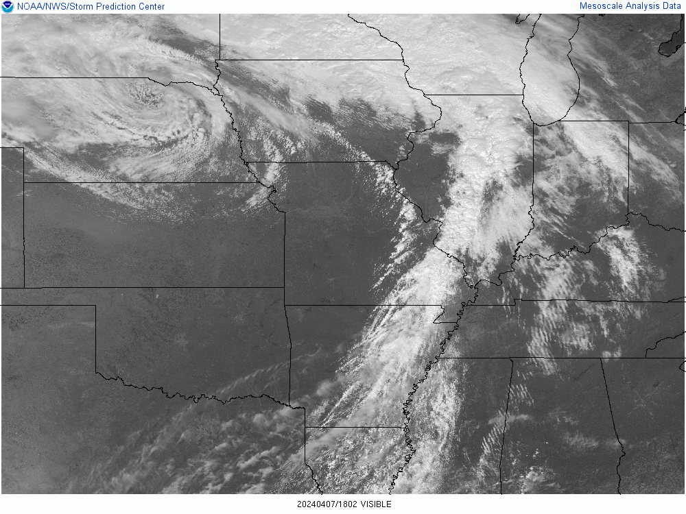
You'll note that on this loop, you can see 2 cloud streams. The one to the south is from the Sub Tropical Jet Stream. That's the one I'm most concerned about but it looks like it may barely stay south of the Ohio River.
The more visible, brighter white, Pacific Jet Stream band of clouds, farther north looks like they will be whizzing by on Monday, probably early in the day (-:
So it looks good........but just barely. We still have 24 hours and there are alot of open skies to the west!
+++++++++++
Here's one with the Midwest. I'm unable to copy the loops because it's too much data for this site to handle:
https://weatherstreet.com/midwest-us-weather-satellite.htm
You can see the back edge of the Pacific jet clouds, marching quickly thru Missouri. The speed will be slowing down the next 24 hours but plenty to get into Indiana before the eclipse(hopefully).
The darker sub tropical jet, LOWER clouds are hiding under the lighter/higher clouds but are aimed at TN right now. Some getting into KY. With the upper ridge in the south building the next day, putting us in negative vorticity from the Pacific jet stream, these clouds could also push a bit farther north. They are the main wild card threat which the models will not handle well in forecasting skies.
The Moon holds Earth’s 23.5-degree tilt steady. Without our satellite, the planet would wobble, dramatically affecting seasons and climate.
https://www.astronomy.com/science/what-if-the-moon-disappeared-tomorrow/
https://science.howstuffworks.com/no-moon.htm
The moon is also helping to slow down Earth's rotation. In fact, the moon is slowing us down a tiny bit every single day. (If you can divide "microseconds per year" into daily increments, that is.) If we had no moon to slow our roll, we'd be spinning ourselves six-hour days. While that might sound intriguing, keep in mind that it would lead to all sorts of consequences. There would be increased wind and storms for one, but it would also probably have affected how life evolved on our planet. With only a few short hours of daylight and darkness, who knows what plants and animals could have developed — or lost out.
And then there's the matter of our axis. The moon stabilizes us to keep that nifty 23 degree tilt that makes for mild seasons and environments. Without the moon, we might be careening from upright to sideways. With a near-zero degree tilt we'd barely see a few minutes of sun or — like Uranus, with its 97-degree tilt — we might find ourselves in 42 continuous years of sunlight, followed by 42 years darkness. And make no bones about it – it would be pretty darn dark without the light of the moon beside us.
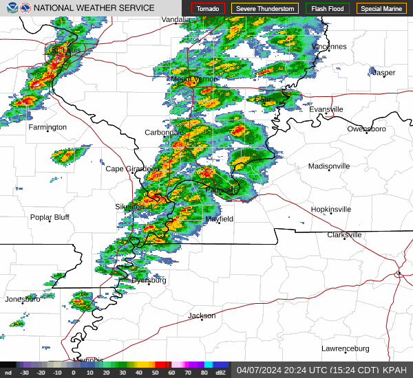
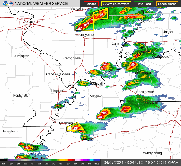
These clouds coming thru late this afternoon/evening have a few thundershowers.
The last AI from the weather models has dropped cloud cover at 2pm tomorrow to just 21%. This is NOT a new product.
Greater than the Sum of its Parts... The NWS National Blend of Models
https://www.weather.gov/news/200318-nbm32
+++++++++++++
We should note the latest satellite loop thru 4pm shows the same movement described earlier which puts us on track to have very few clouds during the eclipse.
https://weatherstreet.com/midwest-us-weather-satellite.htm
The weather in southwest MO/northwest AR right now will be our weather on Monday. Mostly sunny and temps in the 70's. Southwest breeze around 10 mph.
These were the clouds at sunset on the visible satellite. Time to go to the infrared images.
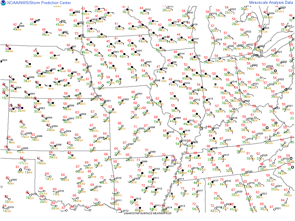
Surface observations show the mostly clear skies across MO have spread into west/central IL, behind this wind shift/dry line. DP's in MO right now are in the 20's/low 30s in the bone dry air. Very low dew points will help to minimize low clouds Monday Morning.
UPDATE: We will never be in that driest air the first half of Monday...........so low clouds are possible early.
Winds behind this front are from the SOUTHWEST with warmer/much drier air behind it. It's an extremely unusual front for us. Not really a cold front. Not a warm front either, which comes from the south with higher humidity/DP's(we actually have a warm front going thru now)
It's the type of dry line/dry front that the Western Plains often sees from air that has been dried out traveling over the Rocky Mountains.
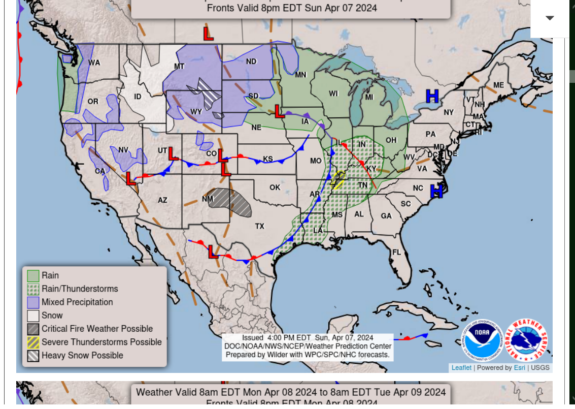
You can see the kink in the isobars below with the dryline/dry front to our west.
The kink in the isobars on top of us and to our east is the warm front.
Current temperatures:
BONE DRY air behind this dryline/dry front/trough. That's exactly what we want for Monday.
https://thermastor.com/dew-point-and-weather-maps/

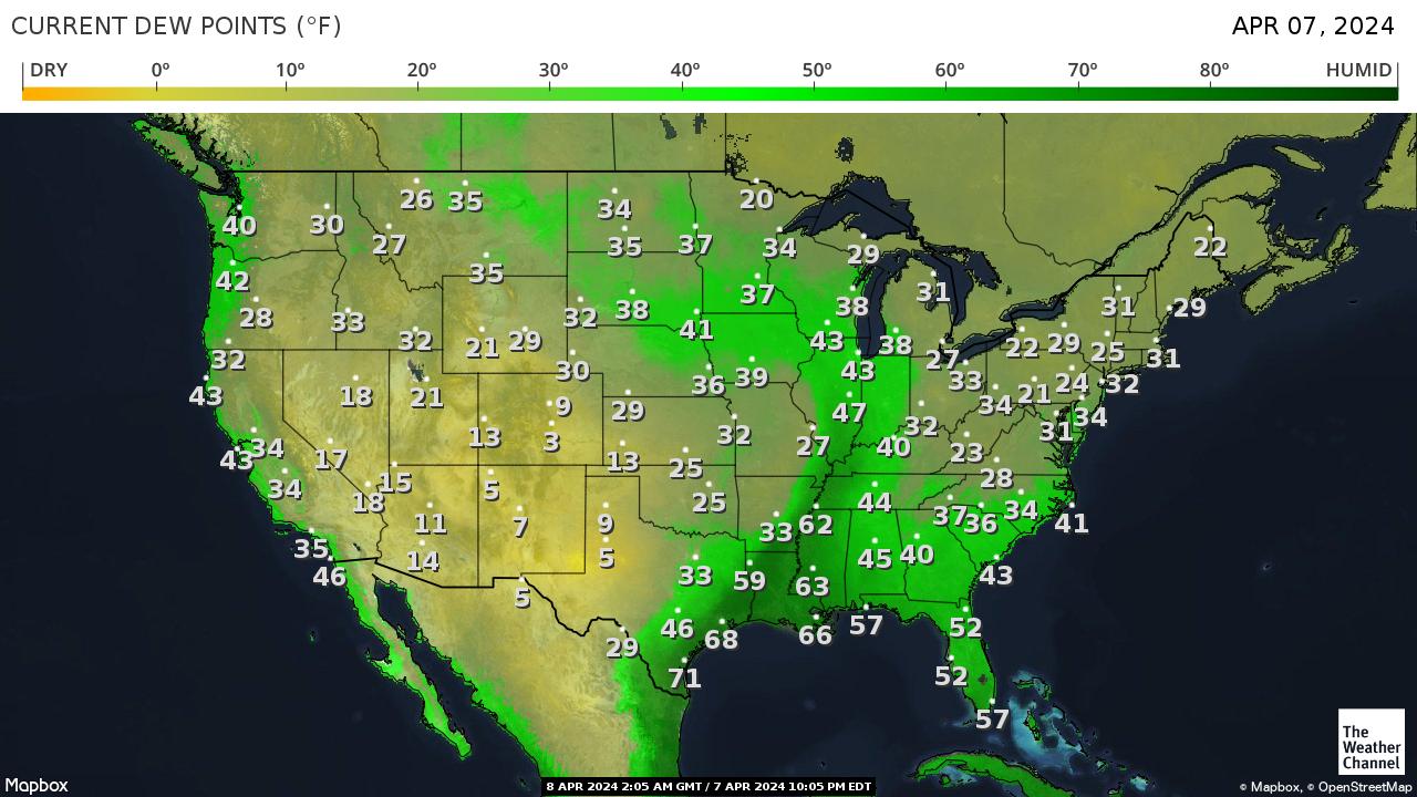
I was just checking station dewpoints right now in the region. Amazing disparity and DP roller coaster we're having
In Evansville:
1. DPs this morning were in the 30's
2. DPs this afternoon having been climbing thru the 40's
3. DPs will be getting into the 50s this evening. Mt Vernon IL has a current DP of 61, so we could have DPs above 60.
4. The DP in St. Louis has plunged! Between 5 and 6p, the DP dropped a whopping 28 degrees, from a slightly humid 56 to bone dry 28 deg. F. IN JUST 1 HOUR.
But the temperature went UP 3 degrees from 73 to 76 deg during that same hour.
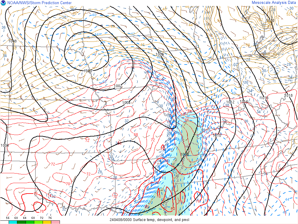
Additional analysis: The pressure gradient under the surface low in northwest IA driving this right now will weaken overnight and the west component in the wind will drop off as the dry air tracks into IL tonight.
As a result, I'm thinking the real dry air will never get here. However with a southwest wind on Monday, enough west component will let dry air leak in and DPs should be able to get into the 40's again by afternoon.
So any low clouds early from higher dewpoints should be able to burn off in the morning with drier air filtering in and the clouds not being very thick.
Below was the last infrared image just before 8pm. If we have low clouds overnight, it may not do a very good job picking them up.........but we have surface observations and 7 hours of daylight on Monday before the eclipse.
We should still be in good shape on Monday. Considering all the clouds in recent days we will be very fortunate to have this weather on Monday! The next total solar eclipse in IN is 129? years from now. It's not like we get a 2nd chance. Considering the previous one was so close 7 years ago.......this is incredible!
The dew point, as expected has continued to increase this eveing, now at 55 deg. F.
The much drier air in MO that has crossed into western IL has almost stopped progressing eastward as winds have died down.
Mt. Vernon, IL has a DP of 60. Sparta, which is in the next county west of Mt. Vernon has a DP of 26!
These higher DPs, along with low level moisture and very light winds could cause us to start Monday with some low level clouds.
We're still looking for those to burn off before noon.
https://thermastor.com/dew-point-and-weather-maps/
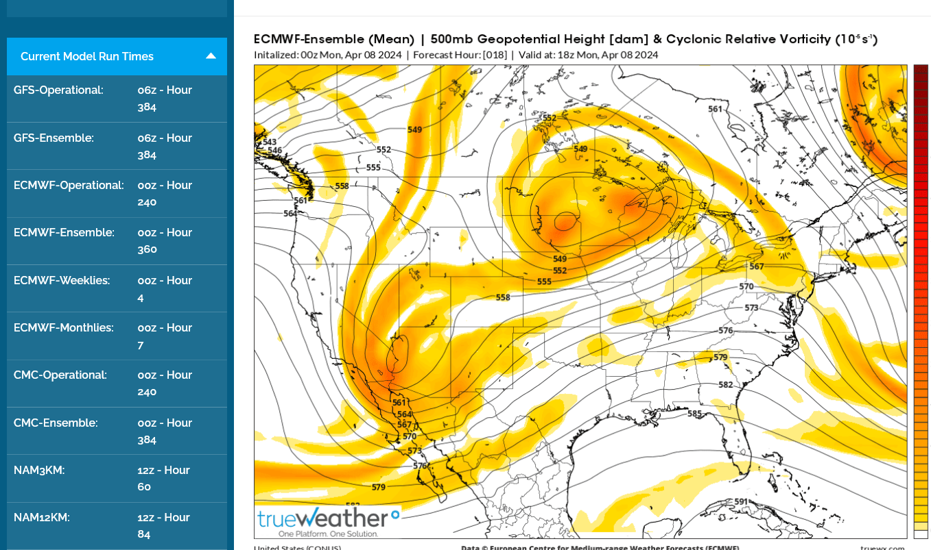
The concerning SLIGHT change was the last 12z European Ensemble model below.
Instead of the slightly negative vorticity predicted the last several days, it has a lobe of very weak POSITIVE vorticity coming over us early Monday AFTERNOON, during eclipse time.
The map below is 1pm Monday. The yellow, along with this washed out surface front stalling over us and most of the dry air staying west means the forecast could bust. It's still mostly sunny but down from 75% to 55% confidence.
The NWS AI numerical product still has only 25% cloud cover and hasn't changed but its based on the American model/GFS products.
In the tens of thousands of weather forecast that I've made(500/year for 42 years would be 21,000 total weather forecasts) this is the only one where that even mattered and in this case, it IS the defining, key, ONLY thing that matters X 20,000! We MUST HAVE mostly sunny skies during the total part of the eclipse or it lessens the profound impact a great deal.
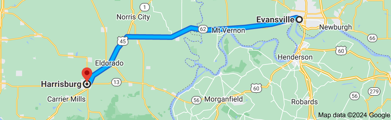
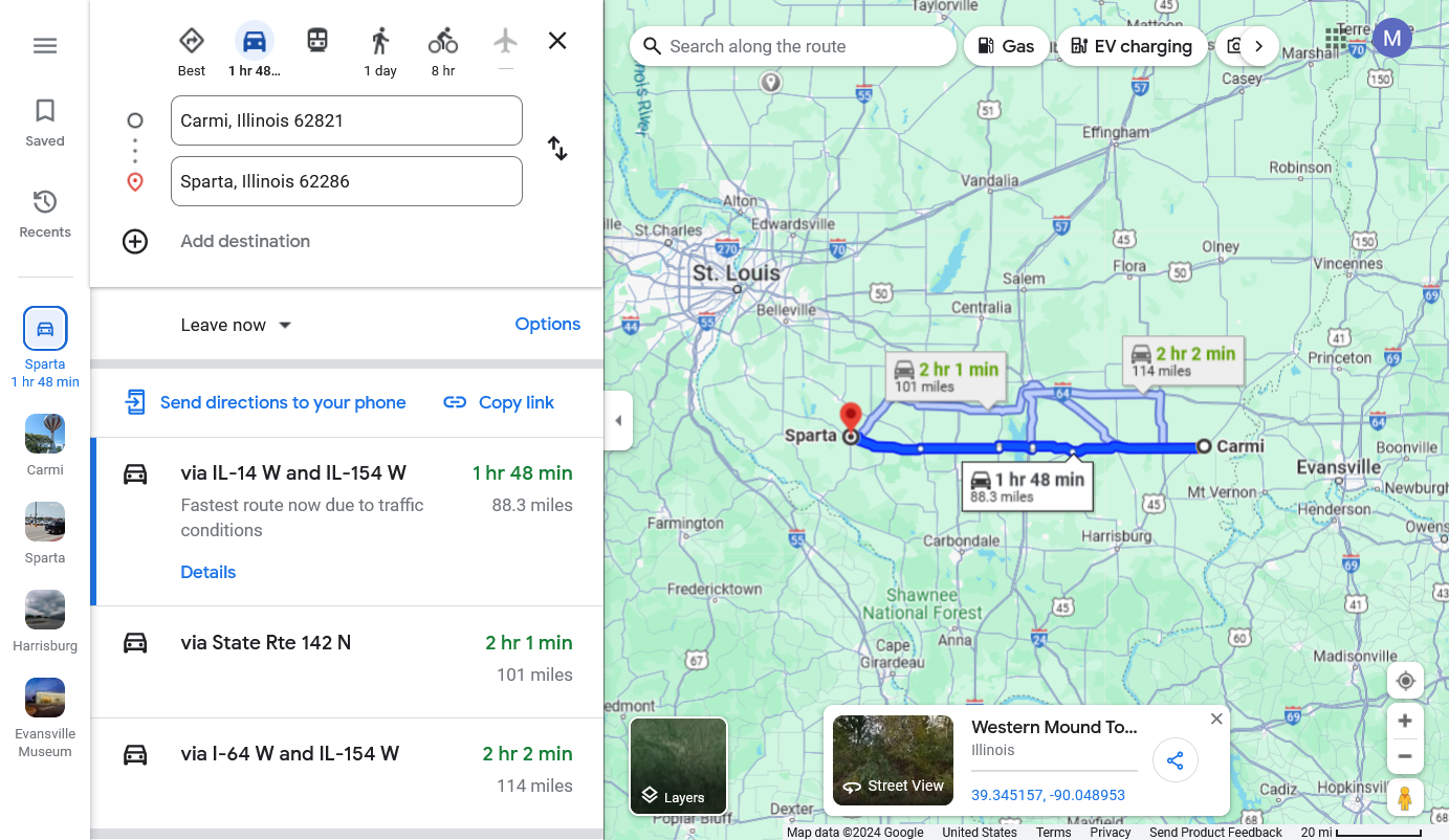
If I were somebody willing to drive to increase my chances of sunshine tomorrow by 10%, I would be driving southwest to around Harrisburg, IL which is 62 miles. BUT THAT COULD CHANGE and there's a good chance of MANY extremely weather savy people monitoring cloud conditions closely online that will be driving to the best place and away from places with clouds.
This is unprecedented, so no way to know but there could be a massive traffic jam of cars trying to get away from the clouds if there are more clouds than expected.
We still look good in Evansville but it has the potential for a bust with a couple of marginal elements. Again, what REALLY matters are conditions starting around 1:30pm with exponentially increasing importance for every minute that passes between then and the 2:02-2:05 pm time of totality.
It starts at 12:45pm but you won't notice anything during the first 45+ minutes, other than a crescent, black shape, slowly eating into the sun thru your eclipse glasses.
+++++++++
11:05 pm
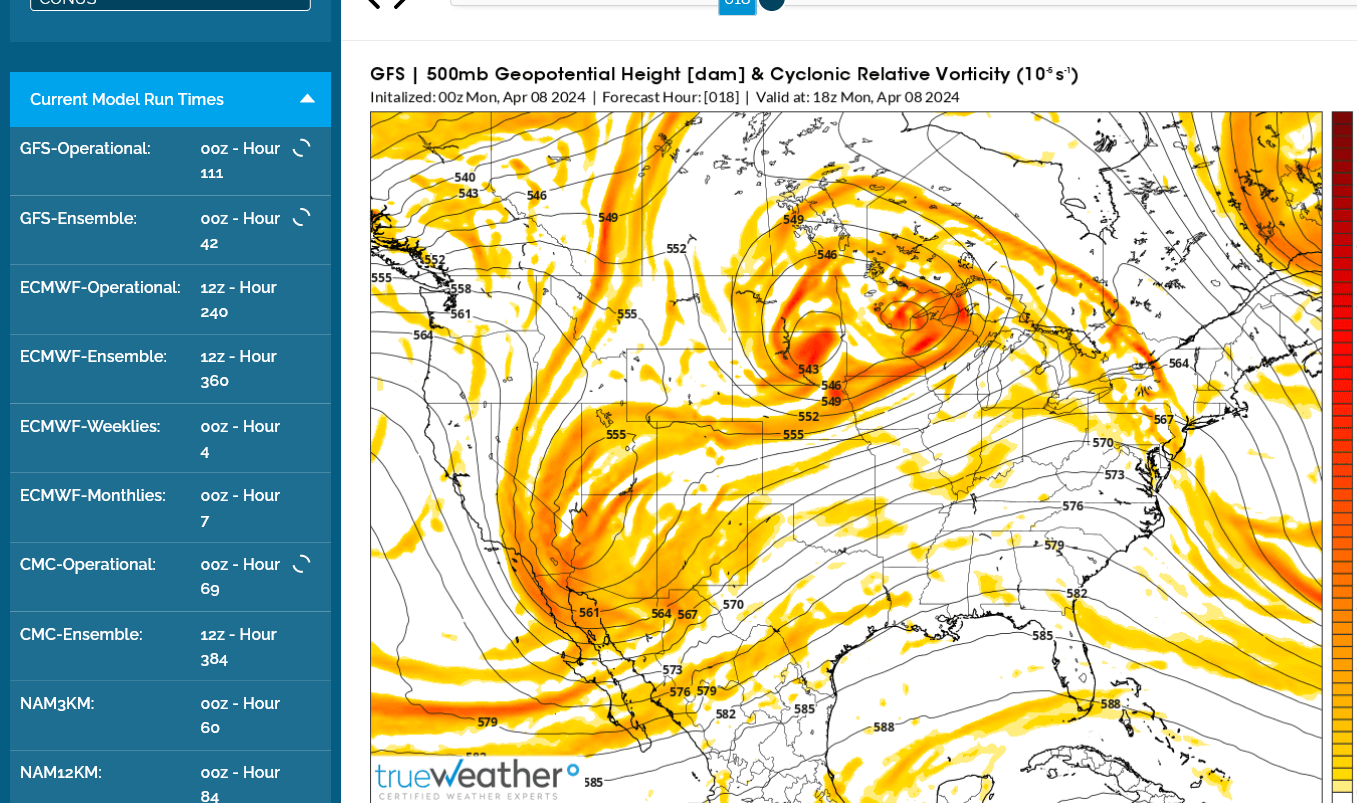
This just out 0z GFS has a bigger chunk of vorticity coming thru early Monday afternoon. I'm not happy to see this and will back off more to 50%. Not sure right now if much would be gained by driving southwest.
Good luck, Mike! I’m going to live vicariously through you. I drove nearly two hours to Orangeburg, SC, for the awesome August of 2017 2.5 minute long total eclipse in the early afternoon. I arrived at a city park ~1.25 hours prior to totality. There were scattered cumulus clouds that were sometimes blocking the sun earlier during the partial phases but they pretty much totally disappeared as totality approached and the temperature dropped!
I sent this message early in the morning but our internet was down:
Glad you got to see that one, Larry.
My oldest son and I drove south for an hour+ For that one in 2017. Mind blowing to have another one in almost the same place just 7 years later.
Only 129 years for the next one in Indiana!
I'm nervously optimistic now that we've burned off the fog/low clouds in the area this morning. Still some clouds around and low level moisture with a DP of 58 degrees.
https://weatherstreet.com/midwest-us-weather-satellite.htm
Evansville, Evansville Regional Airport
https://forecast.weather.gov/MapClick.php?x=285&y=82&site=pah&zmx=&zmy=&map_x=285&map_y=82
https://w1.weather.gov/data/obhistory/KEVV.html
Current conditions at
Lat: 38.04°NLon: 87.52°WElev: 417ft. 
Fog/Mist
61°F
16°C
| Humidity | 90% |
| Wind Speed | S 6 mph |
| Barometer | 30.02 in (1016.3 mb) |
| Dewpoint | 58°F (14°C) |
| Visibility | 2.50 mi |
| Last update | 8 Apr 9:54 am CDT |
Evansville, Evansville Regional Airport
| Enter Your "City, ST" or zip code |
| metric |
| Max. | Min. | ||||||||||||||||
|---|---|---|---|---|---|---|---|---|---|---|---|---|---|---|---|---|---|
| Air | Dwpt | 6 hour | altimeter (in) | sea level (mb) | 1 hr | 3 hr | 6 hr | ||||||||||
| D a t e | Time (cdt) | Wind (mph) | Vis. (mi.) | Weather | Sky Cond. | Temperature (ºF) | Relative Humidity | Wind Chill (°F) | Heat Index (°F) | Pressure | Precipitation (in.) | ||||||
| 08 | 09:54 | S 6 | 2.50 | Fog/Mist | BKN005 | 61 | 58 | 90% | NA | NA | 30.02 | 1016.3 | |||||
| 08 | 08:54 | Calm | 6.00 | Fog/Mist | CLR | 59 | 57 | 93% | NA | NA | 29.99 | 1015.3 | |||||
| 08 | 07:54 | Calm | 1.25 | Fog/Mist | CLR | 54 | 53 | 97% | NA | NA | 29.97 | 1014.7 | |||||
| 08 | 06:54 | Calm | 0.15 | Fog | VV001 | 47 | 46 | 61 | 46 | 97% | NA | NA | 29.96 | 1014.4 | |||
| 08 | 05:54 | Calm | 0.25 | Fog | CLR | 49 | 47 | 93% | NA | NA | 29.93 | 1013.3 | |||||
| 08 | 04:54 | Calm | 0.25 | Fog | VV002 | 50 | 49 | 96% | NA | NA | 29.91 | 1012.8 | |||||
| 08 | 03:54 | Calm | 0.25 | Fog | VV002 | 50 | 50 | 100% | NA | NA | 29.90 | 1012.5 | |||||
| 08 | 02:54 | Calm | 0.75 | Fog/Mist | CLR | 56 | 54 | 93% | NA | NA | 29.90 | 1012.4 | |||||
| 08 | 01:54 | Calm | 10.00 | A Few Clouds | FEW100 | 58 | 55 | 90% | NA | NA | 29.89 | 1012.1 | |||||
| 08 | 00:54 | Calm | 10.00 | Mostly Cloudy | FEW033 BKN041 | 61 | 55 | 69 | 59 | 81% | NA | NA | 29.89 | 1011.9 | 0.08 | ||
| 07 | 23:54 | S 8 | 10.00 | A Few Clouds | FEW038 | 63 | 55 | 76% | NA | NA | 29.86 | 1011.0 | |||||
| 07 | 22:54 | SE 3 | 10.00 | Partly Cloudy | SCT110 | 59 | 55 | 87% | NA | NA | 29.86 | 1011.0 | |||||
| 07 | 21:54 | Calm | 10.00 | Overcast | SCT044 BKN055 OVC070 | 61 | 55 | 81% | NA | NA | 29.85 | 1010.7 | 0.04 | 0.08 | |||
| 07 | 20:54 | Calm | 10.00 | Mostly Cloudy | SCT055 BKN070 BKN120 | 62 | 55 | 78% | NA | NA | 29.83 | 1010.1 | 0.04 | ||||
| 07 | 19:54 | S 10 | 4.00 | Thunderstorm in Vicinity Heavy Rain | FEW032 BKN075 OVC110 | 66 | 52 | 61% | NA | NA | 29.82 | 1009.8 | |||||
| 07 | 18:54 | S 7 | 10.00 | Overcast | BKN037 BKN050 OVC090 | 69 | 49 | 74 | 66 | 49% | NA | NA | 29.80 | 1008.9 | 0.01 | ||
| 07 | 17:54 | S 9 | 10.00 | Mostly Cloudy | SCT075 BKN090 | 70 | 47 | 44% | NA | NA | 29.80 | 1009.1 | 0.01 | ||||
| 07 | 16:54 | SE 12 G 23 | 10.00 | Mostly Cloudy | FEW029 SCT090 BKN110 | 71 | 47 | 42% | NA | NA | 29.80 | 1009.1 | |||||
| 07 | 15:54 | S 18 G 32 | 10.00 | Fair | CLR | 73 | 43 | 34% | NA | NA | 29.81 | 1009.3 | |||||
| 07 | 14:54 | SE 10 G 23 | 10.00 | Partly Cloudy | SCT080 | 72 | 43 | 35% | NA | NA | 29.85 | 1010.4 | |||||
| 07 | 13:54 | SE 18 G 30 | 10.00 | Partly Cloudy | SCT080 | 69 | 41 | 36% | NA | NA | 29.88 | 1011.8 | |||||
| 07 | 12:54 | SE 14 G 24 | 10.00 | Overcast | OVC090 | 67 | 38 | 67 | 45 | 35% | NA | NA | 29.94 | 1013.6 | |||
The dew point dropped 9 deg. F overnight(apparently from moisture condensing out to fog) from 55 deg F to 46 deg. F. It's bounced back up 12 deg now to 58 deg. This is what makes me nervous with some very modest positive vorticity/rising air in our area thru early afternoon.
This was the last 0z European model ensemble overnight. The yellow over us is a bit of vorticity at 500 mb, which is around 18,000 feet. This means slightly rising air parcels which means POTENTIAL for them to cool and condense into clouds. It's going to be close, folks!
Here's another satellite image:
https://www.star.nesdis.noaa.gov/GOES/conus_band.php?sat=G16&band=GEOCOLOR&length=48
Like with the previous one, you can see the cloud movement AND the low clouds around the IN/IL/KY borders burning off after sunrise.
This dew point map doesn't completely capture the incredible gradient now between the more moist air over us and the drier air to our west.
https://thermastor.com/dew-point-and-weather-maps/
The dew point is 62 deg. F at Carmi IL, along the IN border at 10am, while it's just 36 deg. F at Sparta just 88 miles to the west.
That's a humidity of 91% compared to a humidity of 29% in the absence of rain but just from a difference in the air mass over that short distance!!!
Current conditions at
Lat: 38.09°NLon: 88.12°WElev: 387ft. 
Fair
63°F
17°C
| Humidity | 91% |
| Wind Speed | SE 7 mph |
| Barometer | 30.00 in |
| Dewpoint | 60°F (16°C) |
| Visibility | 10.00 mi |
| Last update | 8 Apr 10:35 am CDT |
++++++++++++++++++++++++++++++++++++++++++++++++++++++++++++++++++++
Lat: 38.15°NLon: 89.7°WElev: 528ft.
Fair
70°F
21°C
| Humidity | 29% |
| Wind Speed | SW 7 mph |
| Barometer | 29.99 in |
| Dewpoint | 36°F (2°C) |
| Visibility | 10.00 mi |
| Last update | 8 Apr 10:35 am CDT |
+++++++++++++
A sharp gradient like this in air masses can often cause clouds to form along the boundary. This is what makes me nervous.
We should be good. Just some high cirrus clouds,
Note all the jet contrails in the sky that track across the entire sky.
This is because the humidity is so high at that level. The moisture from the jet exhaust condenses out and is hard to absorb because cold air can't hold much moisture and cold air with high humidity really can't absorb much additional moisture at all.
Cold dry air aloft will quickly dissipate the jet contrails.
This is cold humid air aloft today.
This is also why why we are having all the high cirrus clouds.
You can tell how dry or humid the air is aloft by watching how long the jet contrails last.
Jet contrails are man made clouds!
Our site is loading extremely slow because of so many hits.
I'm really not sure how much the cirrus clouds will interfere with seeing the corona and how many will be exactly in the location of the sun just after 2pm but the main impact for us on the ground viewing the sun for the entire eclipse should still be there.
Hopefully minimal cirrus during the key time frame where the sun is.
Regardless of whether its perfect, we're avoiding sun blocking clouds that would have wrecked it!!!
Yippeee!!!
Enjoy it and remember that we're all connected as human beings, with similarities that dwarf differences.
Differences are insignificant when we unite to enjoy such a wonderful natural event as this total solar eclipse.
We should value every human being on the planet, especially those being dehumanized and suffering.
Appreciate every day for being so lucky to be living in this country and at this time in human history.
That was once in a lifetime fun!
Appreciating the awe of our universe!
My wife and I went to the North High School parking lot with our oldest son and 2 grandsons.
After the eclipse, I let our 14 grandson drive around in the parking lots for the first time with me providing the lesson.
During the last 45 minutes BEFORE TOTALITY, we had some lower clouds blocking the sun for several minutes but they were gone during the final 5 minutes before totality.
It was nothing like the total that Mike got to see today or that I saw in 2017 in SC. However, I still enjoyed the 70% peak cover here. The peak was at 3:08PM. The temp dropped ~2 F from ~2:30PM to 3:15PM (~72 to ~70) under sunny skies with the drop helped by low RH (dewpoints in 40s). It has since risen back. The sun didn’t feel nearly as hot as normal this time of year when sunny.
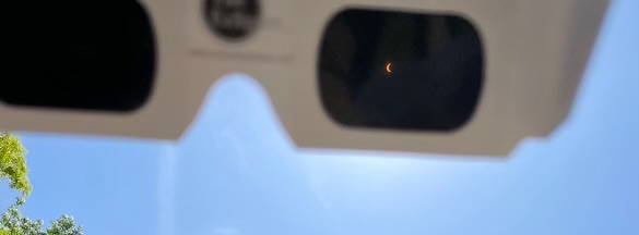
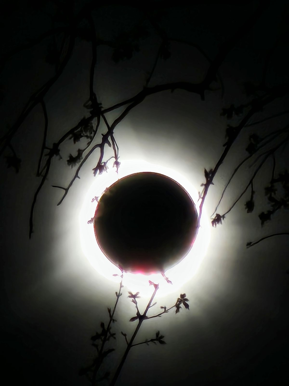
Here’s a pic of what it looked like through my eclipse glasses at 3:12PM (I got lucky to be able to get this pic because I had my phone in one hand and my glasses, which I was able to point right at the sun, in another):

Thanks much, Larry. Great report.
Sorry your picture was too large. We also noticed the temperatures dropping. Felt like 5 deg. F cooler air temp during the eclipse and 10+ deg. F cooler over all from no warming sun.
The NWS in Evansville saw the temp drop 2 deg.F from 12:54pm to 1:54pm(8 minutes before totality). 75 deg. F to 73 deg. F. Still not recovered at 2:54pm.
The "A Few Clouds" they reported at 13:54(1:54 pm) were making me nervous up until the last few minutes, when they finally passed by.
Really, it couldn't have been better viewing from our location. We actually drove 4 miles north from our house to put more distance between us and those lower clouds approaching from the south.
| Evansville, Evansville Regional Airport |
| metric |
| Max. | Min. | ||||||||||||||||
|---|---|---|---|---|---|---|---|---|---|---|---|---|---|---|---|---|---|
| Air | Dwpt | 6 hour | altimeter (in) | sea level (mb) | 1 hr | 3 hr | 6 hr | ||||||||||
| D a t e | Time (cdt) | Wind (mph) | Vis. (mi.) | Weather | Sky Cond. | Temperature (ºF) | Relative Humidity | Wind Chill (°F) | Heat Index (°F) | Pressure | Precipitation (in.) | ||||||
| 08 | 14:54 | SW 6 | 10.00 | Fair | CLR | 74 | 59 | 60% | NA | NA | 29.96 | 1014.5 | |||||
| 08 | 13:54 | Vrbl 5 | 10.00 | A Few Clouds | FEW040 | 73 | 57 | 57% | NA | NA | 29.98 | 1014.8 | |||||
| 08 | 12:54 | S 6 | 10.00 | Fair | CLR | 75 | 54 | 75 | 47 | 48% | NA | NA | 30.00 | 1015.4 | |||
This was the report from the last eclipse in 2017.
After that one, I remember how 2024 seemed like such a long time off.
Wow, our lives pass by faster and faster as we get older. Enjoy every precious moment in between the big events like this!
This day in history august 21, 2019-solar eclipse(in 2017) Started by metmike - Aug. 22, 2019, 2:01 a.m.
https://www.marketforum.com/forum/topic/37388/
https://www.cnn.com/2024/04/08/world/gallery/solar-eclipse-photos/index.html
+++++++++++++++
Images show the Great American Eclipse, seen by tens of millions of people in parts of Mexico, 15 U.S. states and eastern Canada for the first time since 2017.
https://www.nbcnews.com/news/us-news/total-solar-eclipse-photos-2024-rcna146832
++++++++++++++++++++
+++++++++
Mike said: “Thanks much, Larry. Great report.
Sorry your picture was too large.”
——————-
Hey Mike,
1. That’s great news about your experience today!
2. After cropping it, I was able to post that pic I was trying to post earlier of a view through my eclipse glasses. It is up in it now.
That's pretty cool, Larry. Thanks for sharing!
That was more than 80% for the Atlanta area, correct?
Our official temperature drop was 7 Deg. during the eclipse according to the local meteorologist from WEHT(the station that I worked at over 3 decades ago).
Felt like more than 10 deg. F cooler from no warming rays from the sun.
Yes, ATL was ~82% covered.
We had a drop of temp from 76.8F to 68.9 according to my weather station. Had perfect skies and great weather. Totality was just over 3 min. We made it a great family day right here on the front porch.
We could also see Jupiter and Venus, and Saturn or Mars. Don't know if it was Saturn or Mars or both together.
Hey cutworm,
Great pics! In what state are you?
50 miles nw of Cincinnati
Wow! Those really are awesome pictures, cutworm!
Thanks for sharing them with us.
We sure live at the best time in human history and best place in the world!
50 years ago as a senior in high school, I couldn’t imagine a day like today…..or even the other 364 days Each year.
Eclipses have happened since before humans but the way that we can follow it, capture it and share it with our own personal technology has only come into existence during the 2nd half of the lives of us old farts.
Kids don’t know how good they have it!
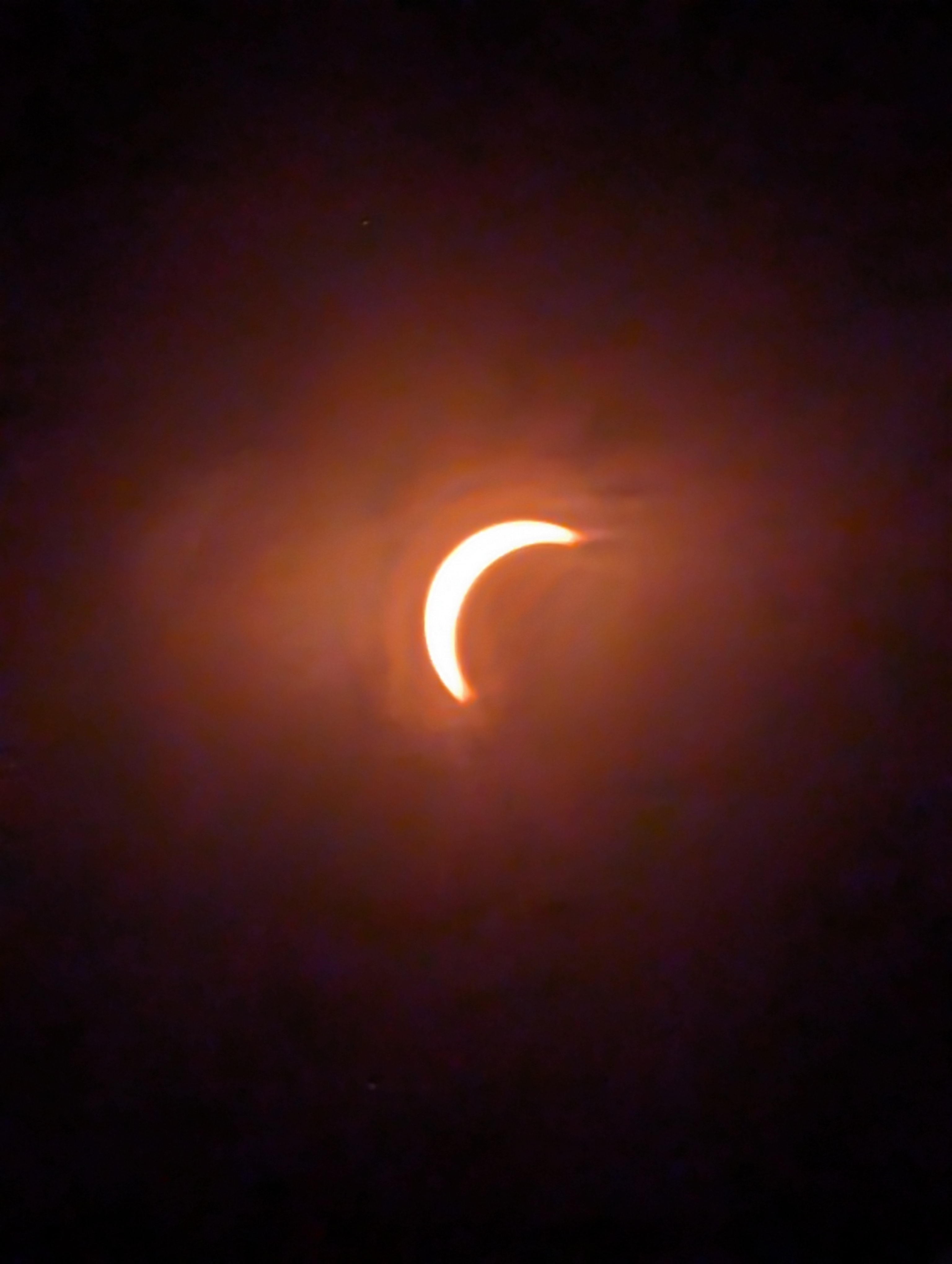
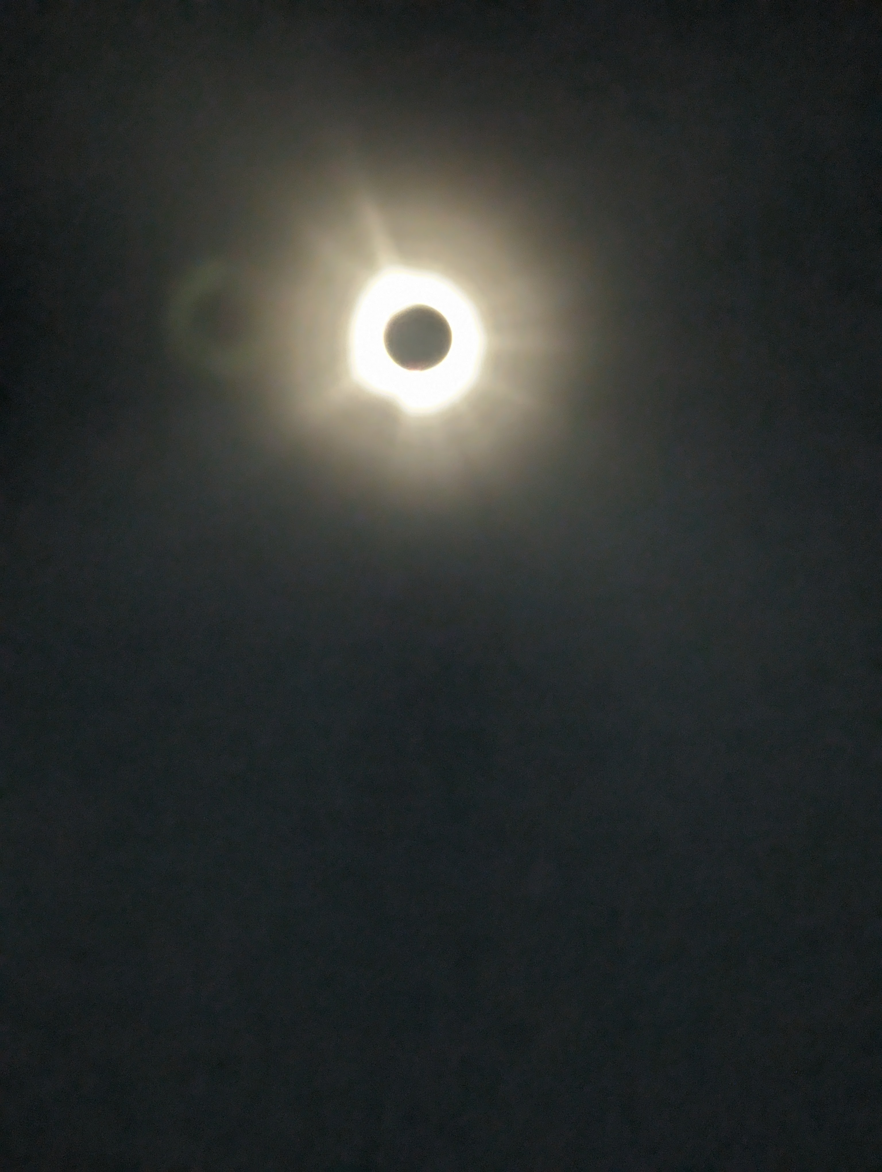
Here's a picture my daughter took here in Evansville outside her house at maximum totality.
Her house is completely surrounded by many dozens of trees, so the image was looking thru a hole in between the trees.
You can see that the branches are just starting to leaf out.
Current Satellite image just after 8am on April 9, 2024.
Imagine if the eclipse was today? Or the next couple of days with a similar sky featuring thick low clouds? How sad because we would have missed 95% of the impact of the total solar eclipse.
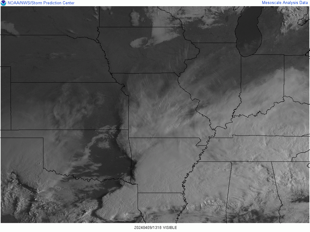
But that didn't happen and instead we had wonderful eclipse viewing weather!
The 4 days following the total eclipse featured cloudy skies in our area in the early afternoon. What great fortune it was for us to have the best viewing weather of the week on the day of the total solar eclipse!!
There won't be another total solar eclipse in Indiana for 126 years.
I'll be 194 then (-: