This is the start of the thread.
Scroll down for additional pages/data for the latest updates! Last page is the latest new page but other pages are constantly updated.
This will be my model update page.
The latest runs will be on top, previous ones below that.
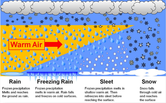
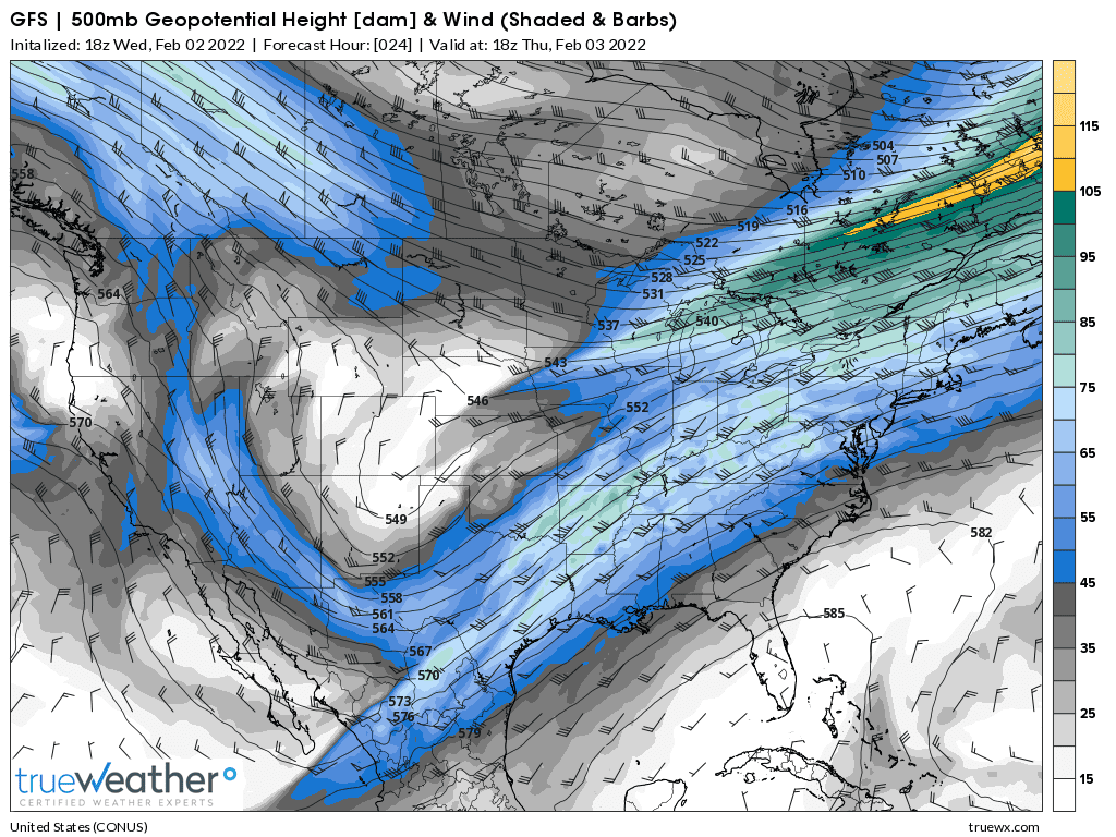
The southern edge of the snow shield below will feature a massive ICE STORM with high confidence.
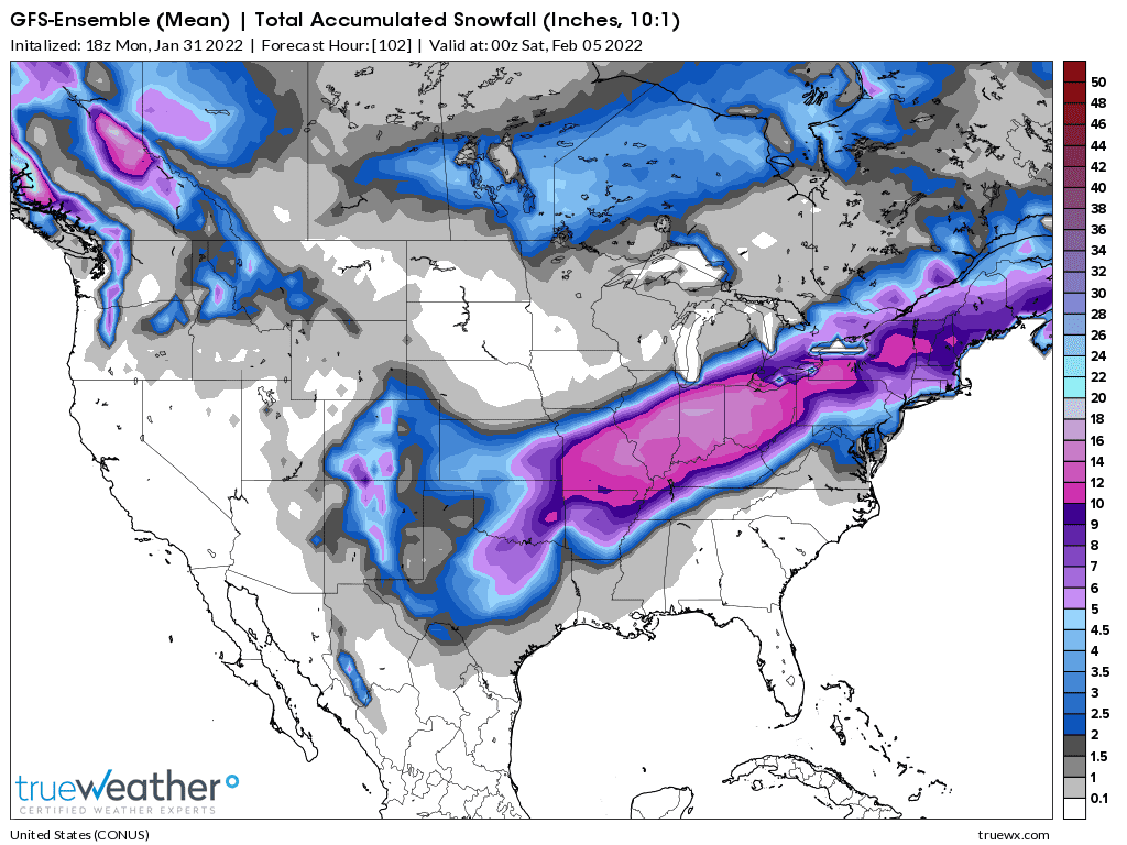
Snows will become HEAVY in NorthCentral MO by midnight Tue Night, then move east/northeast later Wednesday, across IL/IN then to s.MI/n.OH. 12"+ possible by Thursday PM!
Some individual models have 20"+ in n.IN.
Most of the snow may be north of the Ohio River but could shift south with a surge of cold air after the event is underway. The upper levels will be too warm for snow along the Ohio River most of the time with a south component in the wind but at the surface strong north winds will drive sub freezing temperatures down to the Ohio River on Thursday.
This is a classical freezing rain set up........that could change to sleet as the shallow cold air hugging the surface thickens enough to freeze the rain BEFORE it reaches the ground.......stay tuned for MANY updates.
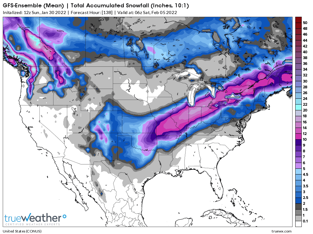
Total snow Thru Friday Midnight below comments are about Evansville IN
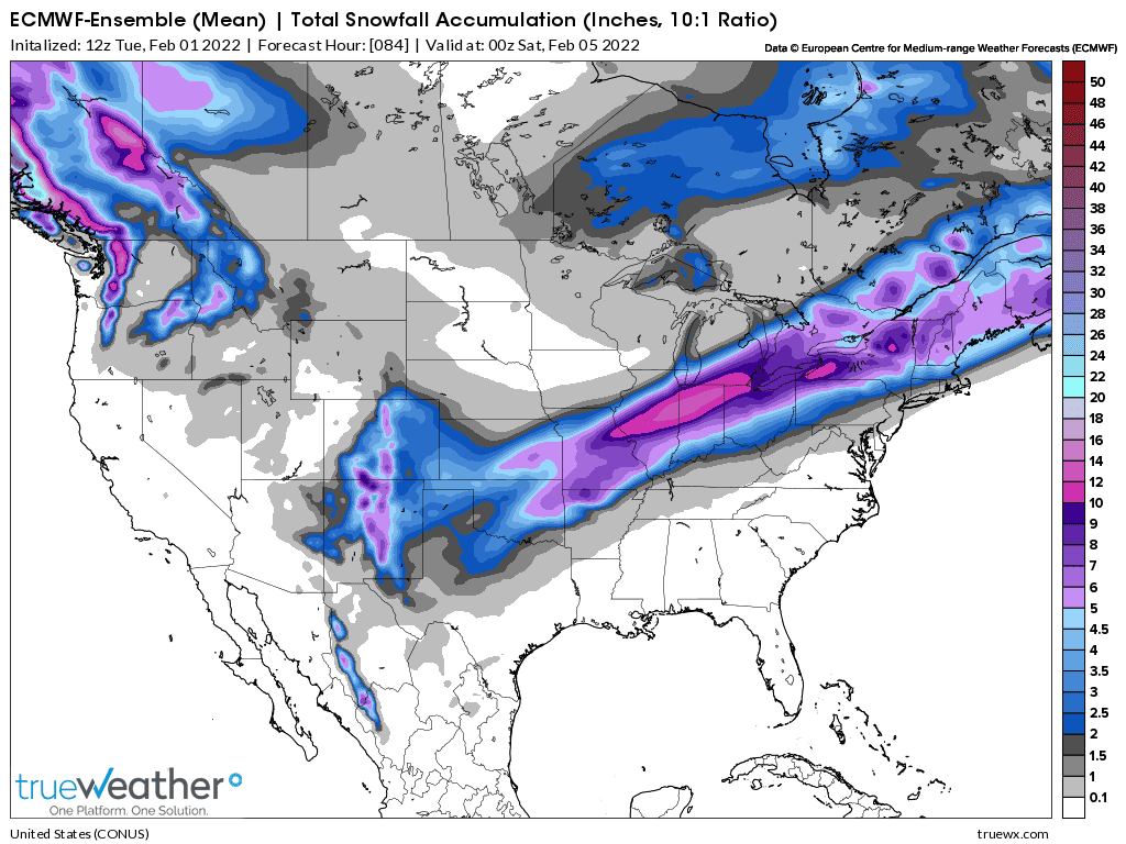
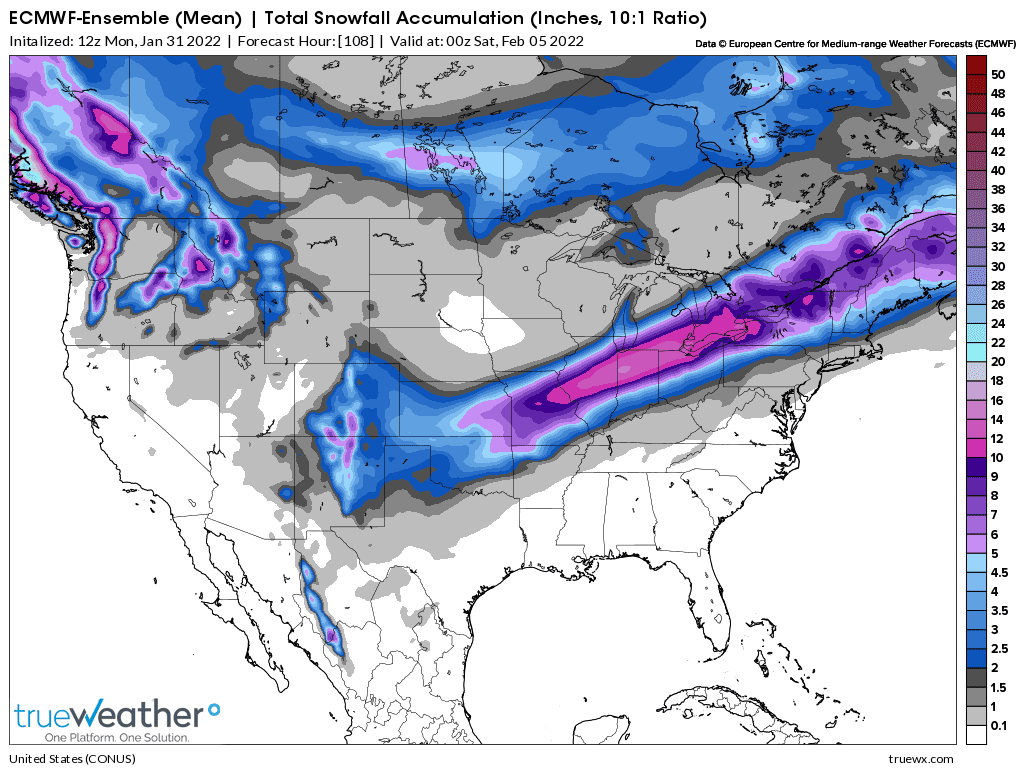
Map 15 European ensemble 1pm Wednesday-What's left to fall
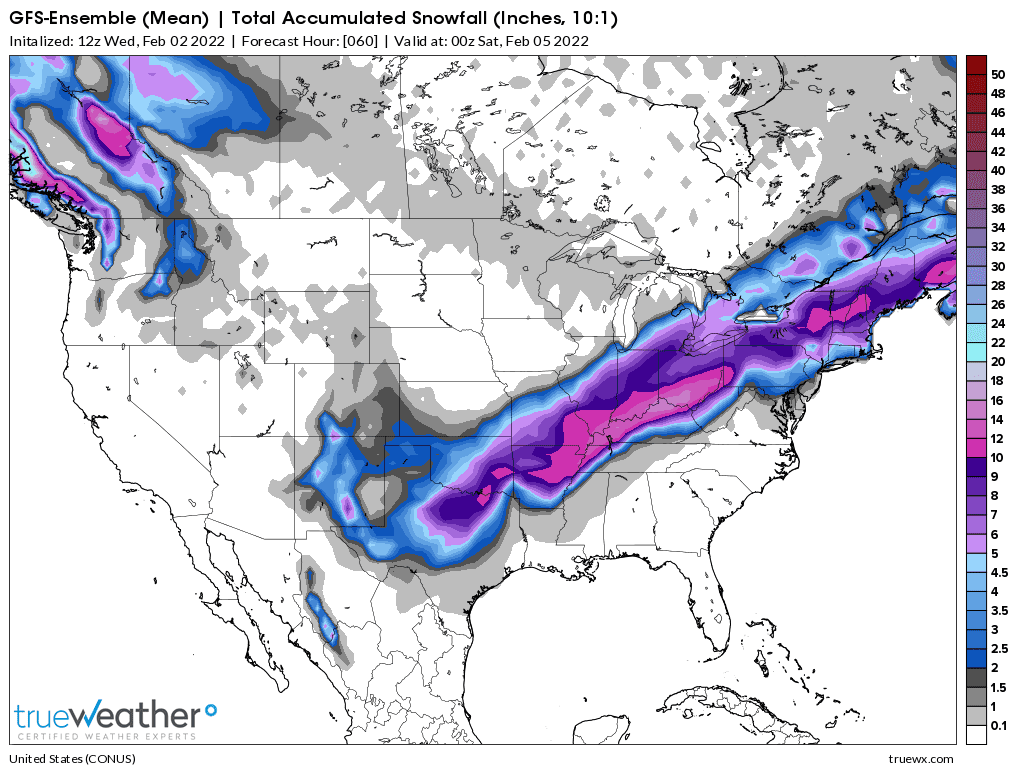
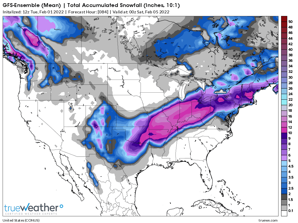
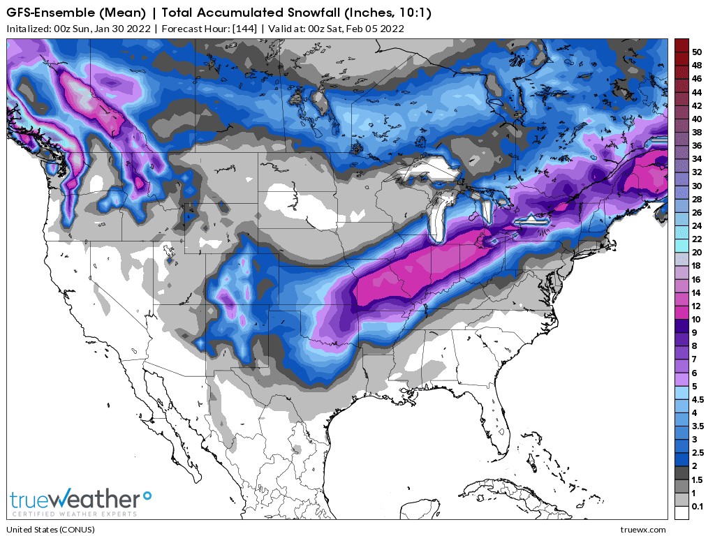
Map 14 GFS at 11am Wednesday-Much of the snow has fallen north, so additional amounts are LOWER because of that. Same solution along the Ohio River.
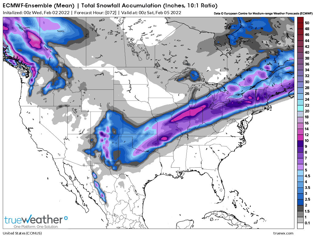
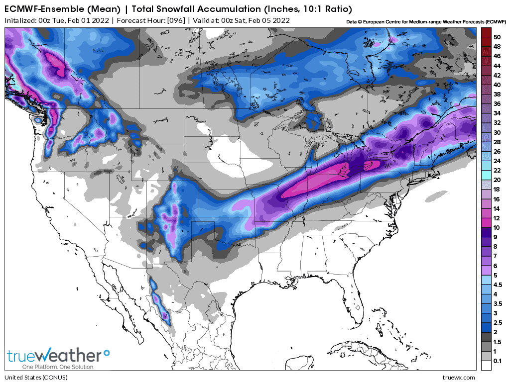
Map 13 European at 1am Wednesday-cutting back on heaviest amounts
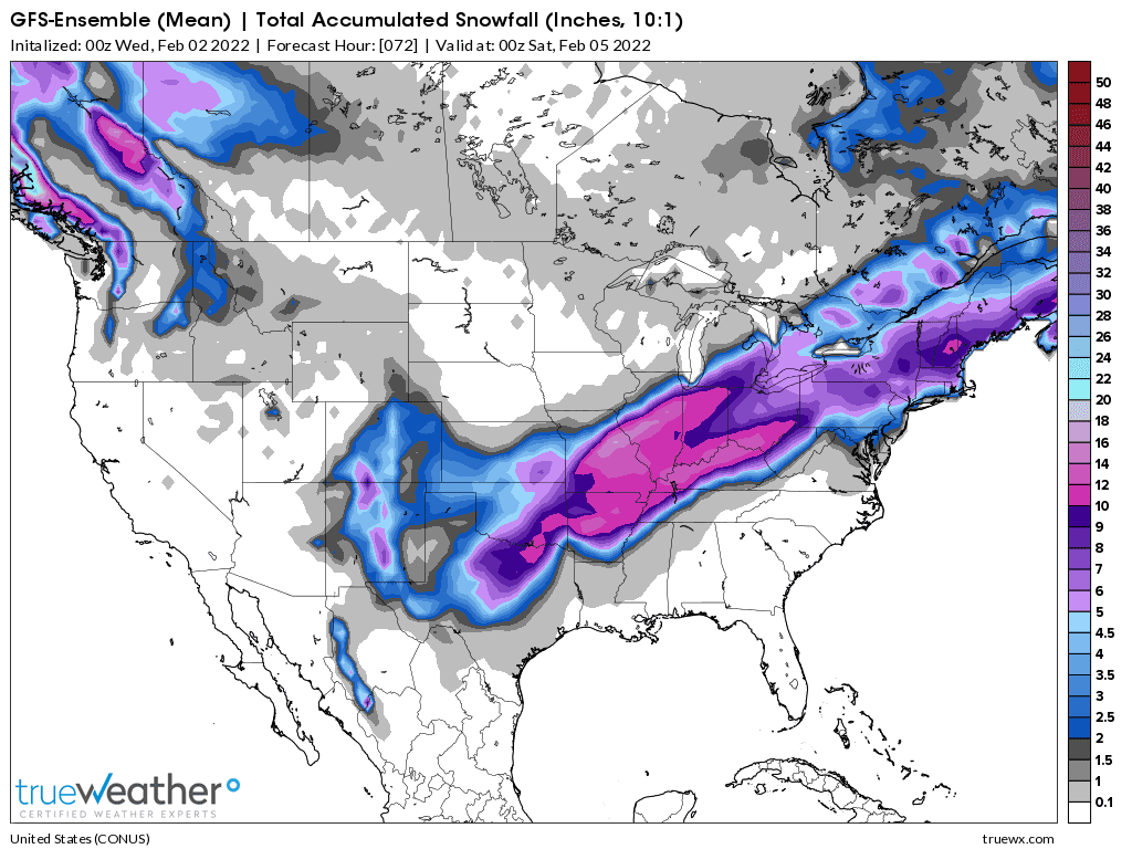
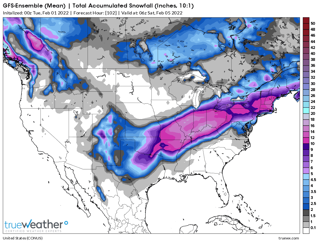
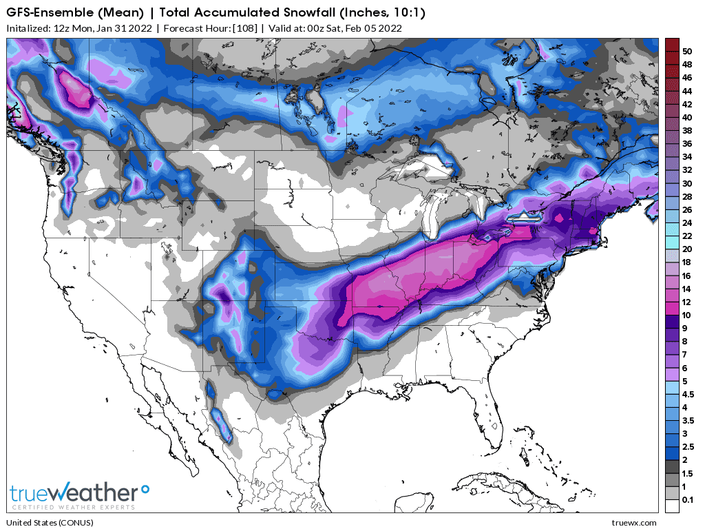
Map 12 GFS 11pm Tuesday-cutting back on amounts!
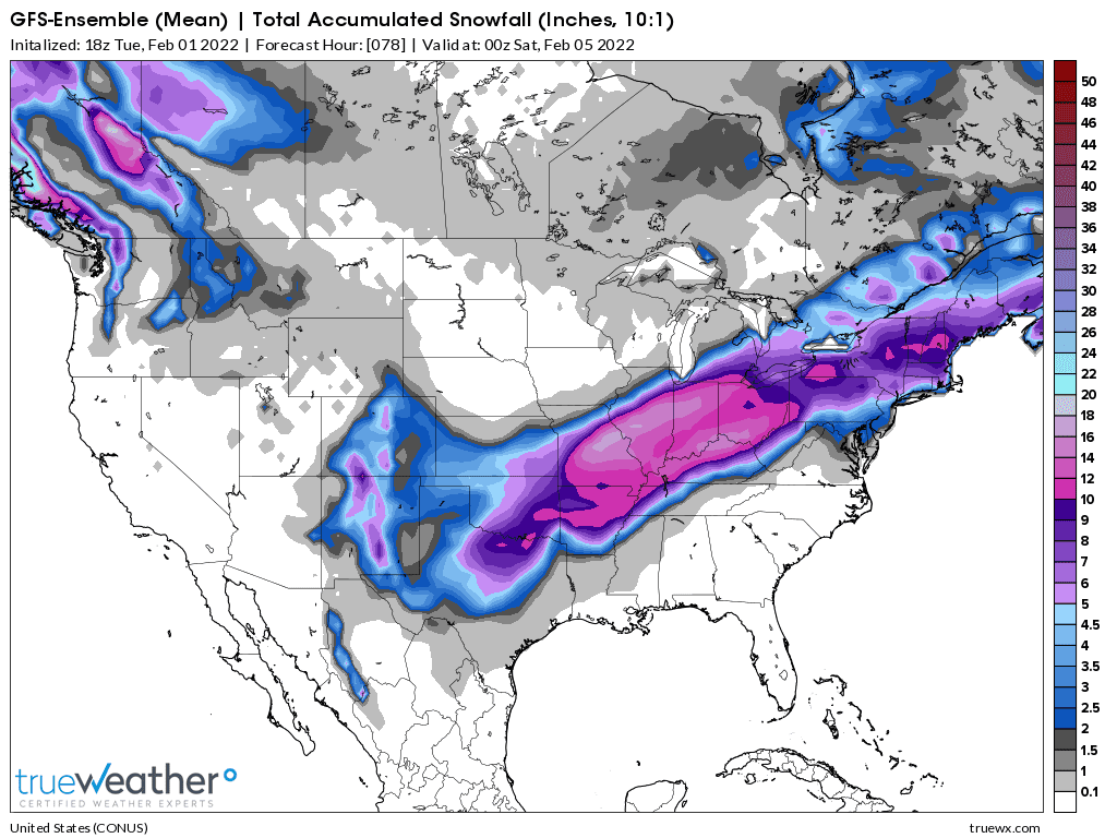
Map 11 GFS 5pm Tuesday-locking in-In Evansville-mostly sleet heavy at times Thursday but could be fr.rain
Map 10 Euro at 1pm Tuesday-still farther north than GFS-ICE in Evansville
Map 9 GFS at 11am Tuesday-a tiny bit farther north than previous GFS sleet storm. How much fr.rain?
Map 8 European at 1am Monday-much farther north than GFS again.........more freezing rain than GFS
Map 7 GFS ensemble at 11pm Monday........farthest south yet. Sleet storm in Evansville
Map 6 GFS ensemble at 5pm Monday............farthest south yet!!! Mostly sleet
Map 5 European Ensemble model 1pm Monday.....it remains much farther north
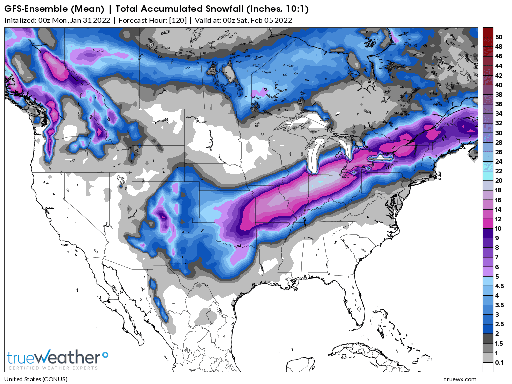
Map 4 GFS ensemble from 11am Monday-frozen precip shifted SOUTH
Map 3 GFS ensemble from 11pm Sunday.
Map 2 GFS Ensemble from 11am Sunday
Map 1 GFS Ensemble from 11pm Saturday.
+++++++++++++++++++++++++++++++++++++++++++++++++++++++++++++++++++++++\
MAP 15-European ensemble-what left to fall. Heavy snow north....is on the ground!
MAP 14 BELOW-GFS 11am Wed-much of the snow has fallen already north-not much change from previous solution farther south.
MAP 13 BELOW-European 1am Wed-locking in.......not quite as heavy
MAP 12 BELOW-GFS 11pm-Tue
MAP 11 BELOW-GFS
Map 10 BELOW- European model still farther north than GFS!
MAP 9 BELOW-A smidgen farther north than previous GFS
MAP 8 BELOW-snow/ice back north of the Ohio River-Euro model
MAP 7 BELOW-snow/ice farthest south yet by far!
MAP 6 BELOW-snow ice farthest south yet!
MAP 5 BELOW-snow/ice farther north-European model has always been farther north
MAP 4 BELOW-snow/ice farther south
Map 3 BELOW
MAP 2 BELOW
MAP 1 BELOW
https://weatherstreet.com/weather-forecast/Snow-Depth-US.htm
National Snow Analyses
https://www.nohrsc.noaa.gov/nsa/
Current Snow Depth
https://www.wunderground.com/maps/snow/snow-cover

Surface map on Thursday late afternoon. The blue line is the 540 thickness line which is considered to be the rain/snow line.
Weather forecast maps from NOAA's Weather Prediction Center
https://www.wpc.ncep.noaa.gov/#page=ovw
Days 1, 2, 3 below. Save the links that I provide at Marketforum to use in the future!


Here are some good links to follow this event live:
Local NWS for Evansville Indiana:
Our weather thread:
https://www.marketforum.com/
+++++++++++++++++++++++++++++++++++++++++++++++
https://www.wunderground.com/maps/radar/current

This link below provides some great data. Hit the center of the box below for the area that you want, then go to observation on the far left, then surface observations to get constantly updated surface observations.
 |
For Evansville, this is looking like an ICE storm.
Rain on Tuesday with a temperature above 40 early in the day. A strong cold front will go thru late in the PM and drop the temperature to below freezing after midnight, changing the rain to freezing rain.
There will possibly/likely be a VERY LONG PERIOD of freezing rain(rain freezing AFTER it hits the surface), possibly over 12 hours with heavy, damaging accumulations of solid ice on exposed objects.
Maybe over 1/2 inch+ of solid ice before the amount of cold at the surface gradually thickens enough so the rain freezes BEFORE it reaches the ground and changes to SLEET/ICE PELLETS on Thursday Afternoon.
On Thursday evening, the thickness of the cold will extend high enough for us to change to snow.
If the rain is heavy enough on Thursday, it will prevent major icing while the intensity/rainfall rate is high.
Also help keep the temp from dropping into the 20's.
Sleet piling up:
https://www.youtube.com/watch?v=xm6uulUkuCk
https://www.youtube.com/watch?v=b0NLZGaFm8c
Freezing Rain and Sleet
https://www.weather.gov/rnk/Measure_Icing
Hello, MetMike
Curious---Is this major weather event "easy" to forecast (as opposed to say a summer storm)?
Secondly, is snow "kinda" moving east and south of prior paths? (Seems my location, Ottawa, Il might be getting less than say Saturday forecast)
TIA
Great questions tjc....Yes, in most ways Winter Storms are Much easier. Winter storms are often generated by large scale features over huge regions that have similar weather you just need to pinpoint boundaries and time frames.
Severe weather events have conditions favorable for severe storms/tornadoes to occur over large regions that can be identified ahead of time but in most places........NOTHING severe happens. Even when WARNINGS are issued, many of those places will NOT have severe weather. With a tornado WARNING 99.99% of the people will not have a tornado.
With Winter storms, in most places Winter weather DOES happen, you just have to pinpoint what kind, how much and exact time frames.
When a warning is issued, almost everybody in that area will have the Winter weather advertised. It might be worse or better than expected but most people will have it.
We've had numerous different tracks for Winter Storms this Winter. The upper level trough/jet stream has moved around a great deal with a northern stream and southern stream, phasing like on the East Coast over the weekend and being separated this time/opposing each other which will cause the ice storm this time.
Southern branch bringing up warmth/moisture in the upper levels from the south...........Northern branch undercutting it with very cold air from the north at the surface.
Luckily, we have some thaw before we get hammered again. I know I'm going to do a better job to stay ahead of it this time. I doubted the last forecast and paid dearly. I had to drag my snow thrower out of the shed which is at the back of my yard. It broke the minute it started running. It took me 2 hours to shovel my truck out so that I could even go anywhere to get the parts I needed. Ugh.
I can see why people die of heart attacks when shoveling snow.
Thanks Jim!
Just updated 12z-Mon GFS run has shifted the heavy snows a bit farther south! We'll see if other models concur:
https://www.marketforum.com/forum/topic/81050/
European model is still north of the Ohio River!
That doesn't break my heart
Hazards map shows how extensive this will be and being issued days ahead of time!!
I have to have my wife at a medical centre for lazer work on her eyes, this coming Wed. She had cataracts removed but some thing happened to need further surgery. Nothing unusual as approx 30 % have the same situation. The thing is her eye sight is rapidly getting worse and I don't want her to have to cancel the appointment
According to your weather maps we should be okay for Wed.
Tim at one time questioned why two vehicles on a farm. A very legitimate question
MY Ram HD 1500 hemi will plow through 3' drifts unless packed by snow plows which won't happen that soon. I doubt we have that much snow any way, but in an emergency, when you are 25 miles from medical help, my pick up will go where ambulance will not try with out a snow plow ahead. An appendix or similar needs immediate medical help and our roads don't get cleared so often after a snow storm
That is when you appreciate a heavy 4 x 4 truck to get you were you want to go. If the truck can't get thru then the 4 x 4 back hoe works in a pinch, not so comfy, but it will buck snow drifts any height. You need to meet some body on a plowed road to get to medical attention
Just one reason of many ways to be prepared for winter or summer storms with no power etc. A portable generator may not be used in a yr or two but golly when you want power, there is nothing like running water and a pot to heat water plus cook on the emergency stove top electric burner, with electric space heaters in the winter.
We don't have a fire place but a few cans of gas keeps the generator going for a long time. You learn survival in the country. I some times wonder about a diesel generator then lots of fuel in the diesel tank
My wife will have her surgery unless the icy roads prove a problem In which case we leave extra early and drive safe. If I do get stuck in the snow the family has enough tractors, parked around the country, to pull me out. I have tow hooks front and back on the pick up, plus I carry tow straps No problem deciding a safe spot to hook a tow strap. Not with plastic bumpers. Squirrling into the snow to hook onto the frame is no joke.
Any way such is life on the farm
I have a back hoe to clear the drive way of snow Push, pull pile what ever it takes.
Didn't always have all this equipment in early yrs of farming but slowly accumulated some equipment, once a few extra nickels and dimes were available
Any way tks for the weather update
YW Wayne!
W.Ontario will probably have some light snow late in the day on Wednesday, so you'll be ok.
Updated the latest model.........everything shifted farther south. Evansville could be a heavy sleet storm based on the vertical temperature profile.
https://www.marketforum.com/forum/topic/81050/
Shifting everything south means colder air in here quicker on Wednesday night. Possibly dropping below 32 by midnight Wed. night, when the rain will change to freezing rain. But the colder air rushing in at the surface, will thicken the sub freezing layer from the ground up.
Then sleet starts, possibly before dawn on Thursday, when it gets below freezing from the surface to a couple thousand feet up........as the rain falls thru a deep enough sub freezing layer so that it completely freezes before reaching the ground......turning it to sleet(ice pellets).
The sleet could be heavy for numerous hours. Sleet does not stick to the roof(or trees/power lines), so it will all slide down and collect into huge piles around buildings that could be several feet deep if it lasts for many hours.
https://www.marketforum.com/forum/topic/81050/#81091
This is actually a near best case scenario.
Worst case would be if the layer of subfreezing temps near the surface didn't deepen enough to freeze the rain BEFORE hitting the ground........and the rain, instead froze AFTER hitting the ground for numerous hours.......there would be ice accumulating on all exposed objects...... including power lines.
On the road situation.
Very mild temps prior to this event will cause it to take some time after we drop below freezing for freezing rain to cause icy roads. Elevated objects will freeze up quickly though. If we end up having HEAVY freezing rain, during the high intensity it will keep the rain from freezing up easily.
However, it looks like heavy sleet right now. Sleet will NOT stick to power lines, trees or roofs but will make roads slick, about similar to slightly worse than snow but not nearly as bad as freezing rain.
If everything continues to shift south, we could end up getting into several inches of accumulating snow during the later stages of the event on Thursday.
1am: European model does NOT follow the GFS and still has the farther north solution with several more hours of freezing rain before changing to sleet, then snow.
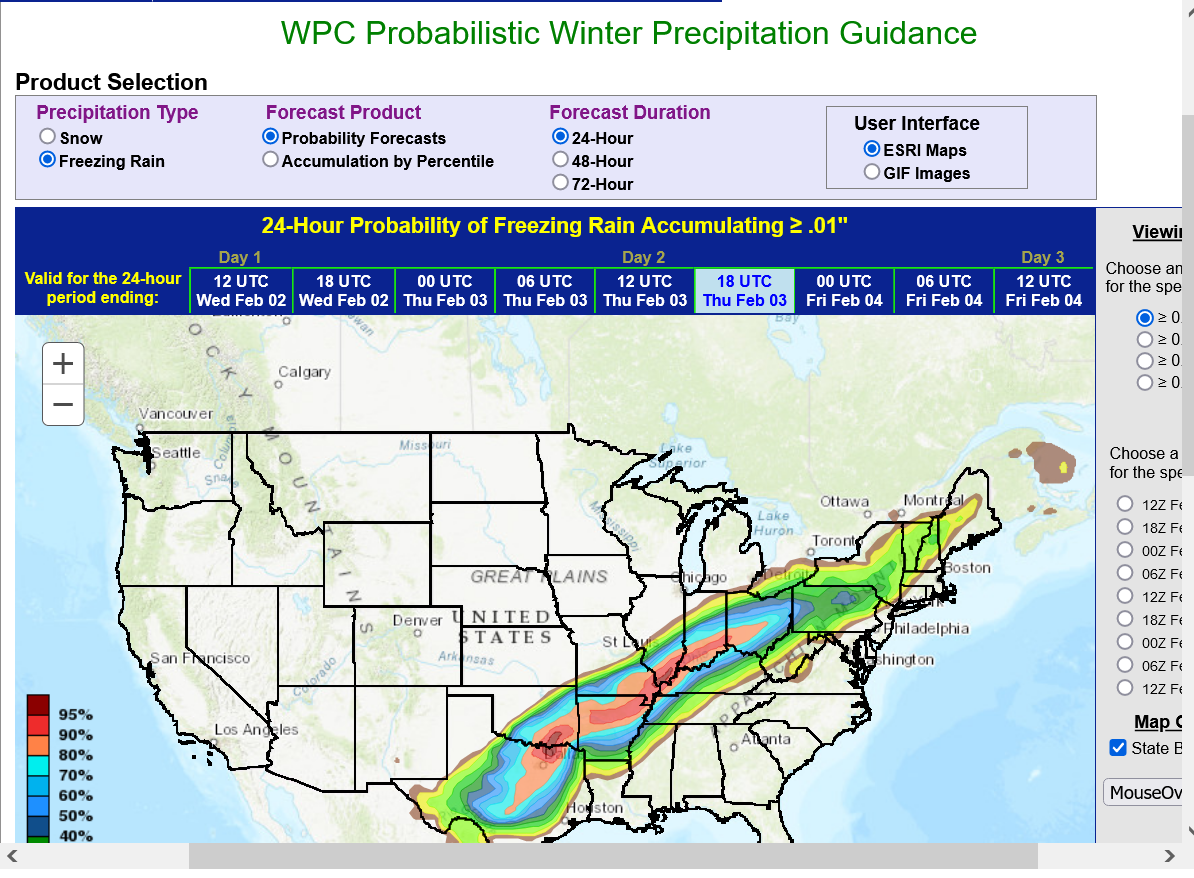
This is the chance of .01" freezing rain on Thursday. There may be some places that get .50" along the Ohio River. That much ice could cause power outages and tree limbs to fall. If you live in those locations, prepare for the possibility that it could happen.
Latest model update at top.
0% chance of school on Thursday.
0% chance of school on Friday.
Frigid temps for a couple days after this will keep rural roads slick.
Watches updated to warnings. https://www.marketforum.com/forum/topic/81050/#81064
Looking at the NOAA website, it appears Ottawa, Il is expected to receive 9+/_ inches between 8pm Tu to 8am Thurs. 60 miles south 12-16!! 60 miles north and west 3!! (Raining kinda hard right now 550pm
I encourage everyone to go to noaa.gov and just "play around". Fun to follow along using your zip code. Check out the radar, etc.
MetMike, this is one of the most well publicized weather events in a long time!
tjc,
Thanks for the great link and all the positive contributions that you make to MarketForum .......which makes it a better place!
We are at the stage now, where we can actually watch the system and do NOWcasting.
Giving the observations more and more weight for what's coming up the next 12 hours and models less weight for the period that close.
Quite a reduction in forecast---now only 3-4 inches (not 9).
Probably 2 has fallen and now to stop 2pm. SIGNIFICANT wind. Schools closed (wisely)
(This is NOT one that will be remembered, other than the exaggeration)
tjc,
Outstanding points! I remember the blizzard of Jan 1978. First time that the University of Michigan closed because of weather.
Not much information ahead of that one. Just the tv weatherman/woman in those days.
The internet has multiplied are resources by millions of times. This thread is a perfect example. Everybody has known for many days that this one is coming and all the details about it.
Back in 1978...........all we got was the forecast and on tv a couple times a day for a couple of minutes a weather person with some stone age, non computer generated maps in the studio.
Showtime!
Scroll down for the later posts, scroll up for the previous posts......and enjoy the information/knowledge because ice storms are no fun but learning always is!!!!
https://www.weathercentral.com/weather/us/maps/indiana/index
https://www.accuweather.com/en/us/indiana/current-weather-maps
https://www.wunderground.com/maps/radar/current
https://www.spc.noaa.gov/exper/mesoanalysis/new/viewsector.php?sector=20#

https://www.spc.noaa.gov/exper/mesoanalysis/new/viewsector.php?sector=20#
maps above updated constantly, not the map below so use the link for the update
https://www.aviationweather.gov/metar/plot?region=evv

NWS Link for this region:
The biggest update in the forecast is that the shallow, dense very cold air mass hugging the surface with good momentum headed south is moving much faster than the models anticipated earlier this week.
So temperatures in Evansville will drop BELOW freezing BEFORE midnight this evening!
It was 64 degrees yesterday, so roads will retain enough warmth to be ok for several hours after the freezing rain starts.
Elevated objects........trees, power lines and others things will quickly drop below freezing and ice will begin accumulating on them until it changes over to sleet, early Thursday morning.
The sooner we change to sleet, the less ice will accumulate on exposed objects.....and the more will fall as sleet.
We can only guess that the change over will be early Thursday. The earlier, the better. Just have to monitor but there will be HEAVY amounts of frozen precip with 100% certainty.
It may end with an inch or 2 of snow on Thursday afternoon.
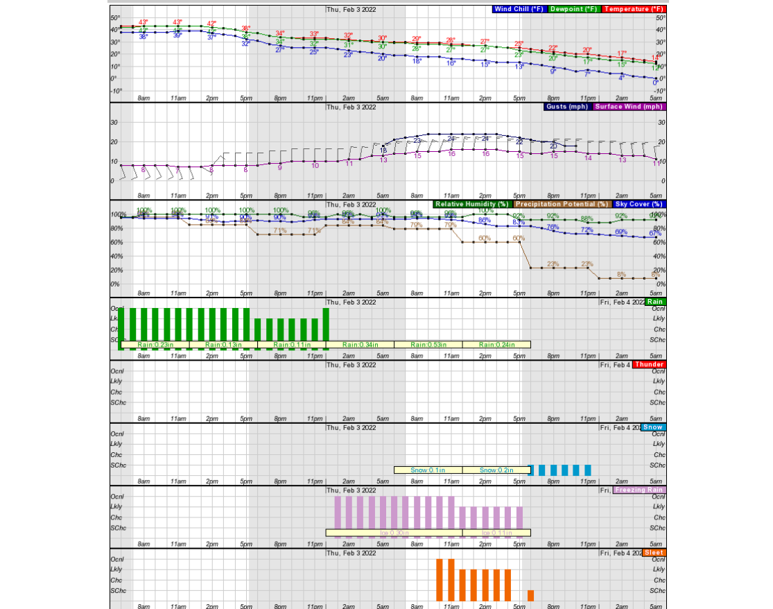
THURSDAY FORECAST:
Based on updated observations:
Heaviest precip in the Evanville area will likely be in the morning, starting maybe around dawn to very early afternoon on Thursday.
Leaning strongly now towards it being mostly SLEET during that time because the surface cold layer will be thick enough for the rain to freeze BEFORE reaching the ground! Probably a couple of inches.
Sleet DOES NOT STICK to surfaces!
When having a for sure ice storm.......
Freezing rain = bad
Sleet = good.
https://www.marketforum.com/forum/topic/81050/#81091
Sleet on the roads will still make for treacherous, slippery driving but is only a bit worse than snow.........you NEVER want freezing rain to cover the roads.....that still could happen very early morning.
BEFORE the sleet hits on Thursday morning, there is likely to be some light freezing rain and freezing drizzle starting, maybe before Midnight that does coat exposed surfaces.
Very warm air temps the last 2 days will allow roads to be ok for the first several hours.
Bridges/overpasses and elevated surfaces will be the first to freeze tonight.
3pm update: The near surface cold air continues to surge in faster than expected a couple of days ago. Could be below freezing in Evansville a few hours before midnight.
Advice on treating your driveway or sidewalk.
Ahead of all frozen precip, it's a no brainer. You can spread the chemicals down before hand, then wait for the event to end to shovel, then retreat with chemicals.
You usually want chemicals first, so that the bottom doesn't melt, then refreeze.
As long as the bottom is not frozen, you can take all of it off, no matter how much accumulation, without scraping or slipping on ice below.
But what if it starts as plain rain, then freezes up? Putting chemicals on too early before the rain ends, means the chemicals get washed off, especially if the drive/sidewalk is sloped.
64 degrees yesterday and warm earlier today will keep paved surfaces above freezing for a couple of hours after elevated surfaces have freezing rain on them.
It's already down to 36 deg. F here at 3pm, so we'll be below freezing by midnight.
I stay up late but this is what I'll do with our mega steep and long driveway that will wash ALL the chemicals off if there is any sort of liquid rain falling.
If the rain has stopped and we are close to freezing, then I'll treat.
If the rain continues, even as we drop below freezing, there is no way it will freeze because it will be running downhill on the driveway.
I think the precip will let up late this evening and will wait as late as possible to treat BEFORE it starts to freeze up.
Waiting until the morning after the heavy sleet starts to fall, if it means the bottom froze first, means its dangerously slick removing whats above the thin layer of ice on the bottom.
However, as mentioned earlier, that warmth from yesterday, heated the roads/soils to a depth of several inches and that heat will still be coming out in the early stages of this event.
A couple inches of sleet will actually insulate that heat for awhile on Thursday but you don't want to wait too long to remove the ice on Thursday AFTER its over because it will freeze real hard on Thursday Night.
NOW-casting using the radar below at 6pm shows exactly what's happening. In the upper levels, we have 2 well defined perturbations/storms triggering the heavier precip. You can really see them.......and the separation between them.
The tail end of the heavy precip from storm 1 will be exiting Evansville in the next several hours, well before midnight as temperatures slowly drop to below freezing. We're already down to 33 Deg.F. I'll wait to dump the chemicals on our drive then, so they don't get washed off.
There will be a lengthy period of numerous hours with just very light freezing rain and freezing drizzle from the warm air aloft overiding the colder air at the surface.
This will coat most exposed surfaces.
Then storm 2 hits very early Thursday, just before dawn with heavy precip returning. Temps will have spent 8+ hours just below freezing so a thin layer of ice(from light freezing drizzle/rain) will be covering most exposed surfaces, though some roads releasing stored heat, below the surface from recent days, will keep from getting icy for awhile after we drop below freezing.
Storm 2 could start as freezing rain still but is likely to be mostly sleet because of the thickening of the subfreezing surface layer overnight.
HEAVY sleet is likely from just before dawn until early afternoon. Several inches of sleet are possible. There could be sleet piles of a couple feet deep surrounding any buildings with a sloped roof since sleet does not stick to anything like freezing rain does and will slide off. This is good!!!
Just depends on how much is freezing rain vs sleet, then snow.
https://www.wunderground.com/maps/radar/current
8pm update:
The temperature in Evansville has dropped to 32 degrees and continues to slowly drop.
The gap in between the end of exiting heavy precip from storm 1..... to the start of heavy precip from storm 2 has been filling in and increasing the last few hours with more freezing rain/drizzle the last several hours.
This is from the warmer air aloft with a south wind component ahead of approaching storm 2, over running the colder air at the surface being driven down by strong north winds.
This suggests slightly heavier amounts of freezing rain with drizzle overnight until it changes to sleet and increases to heavy sleet before dawn.
Amounts of .25"+ of ice accumulating on exposed surfaces are possible overnight....before it changes to sleet, then REALLY increases as the sleet slides off of most elevated or sloped surfaces. Ending as accumulating snow.
Most untreated roads will eventually get icy before dawn.
The veering with height wind direction is what's causing all the ice.
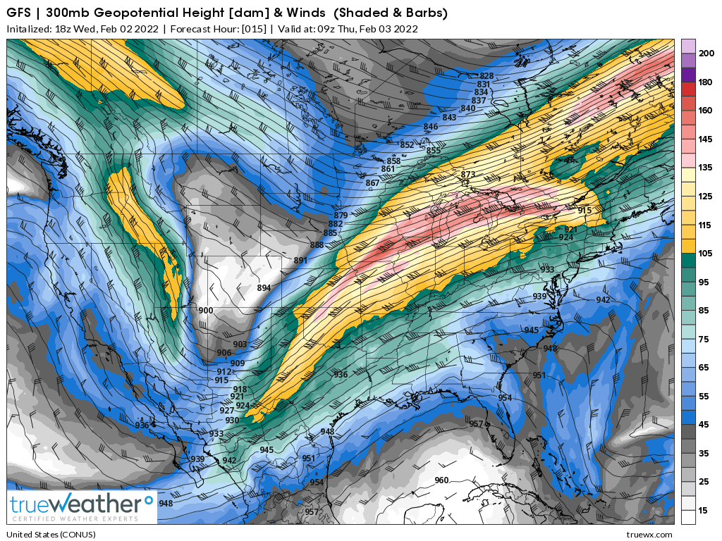
Let's start with the top and work our way down. Wind speed is in knots/hour. 5 knots = 5.7 mph.
This is 30,000 ft up. Note the SW direction. The pink is close to 165 mph. Thats a very strong jet stream!
Down to 18,000 feet and a S/SW direction below
Down to 10,000 feet. A strong S/SW wind still! Warm moist air moving from south to north!
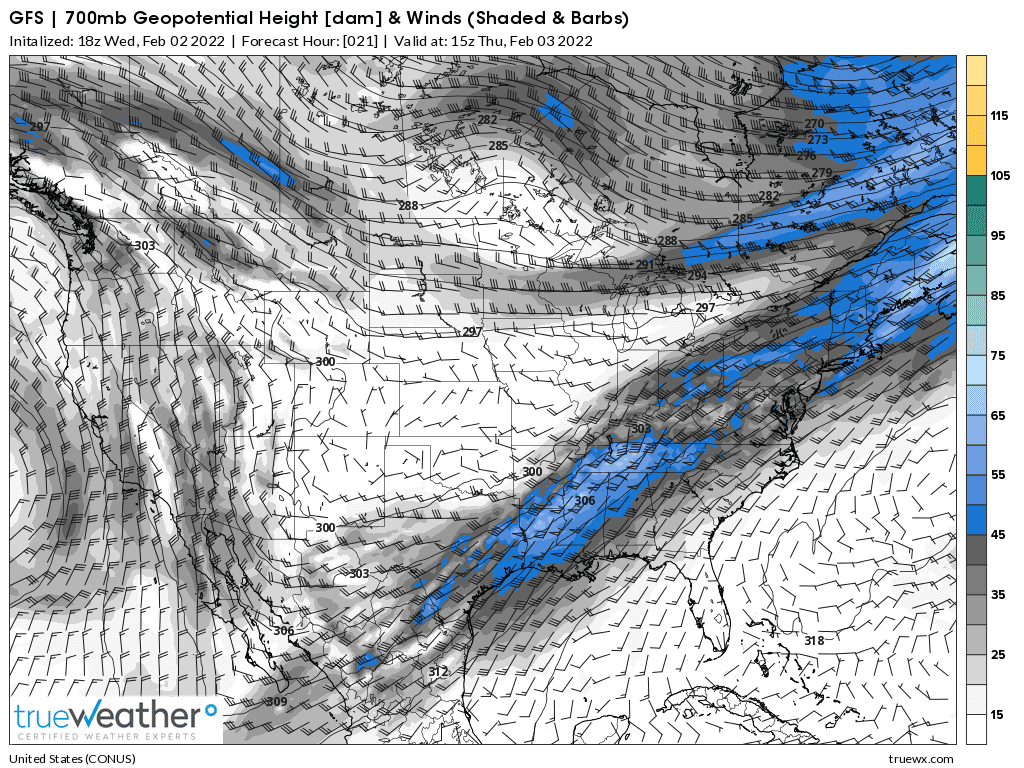
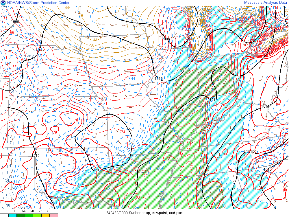
At 5,000 feet( just less than a mile). Strong south winds to just north of the Ohio River bringing up warm, moist air. This is causing the precip to be rain with temperatures at that level several degrees ABOVE freezing. But just north of that, winds flip to northeast in most of Indiana, Illinois with subfreezing temps and the precip all snow.
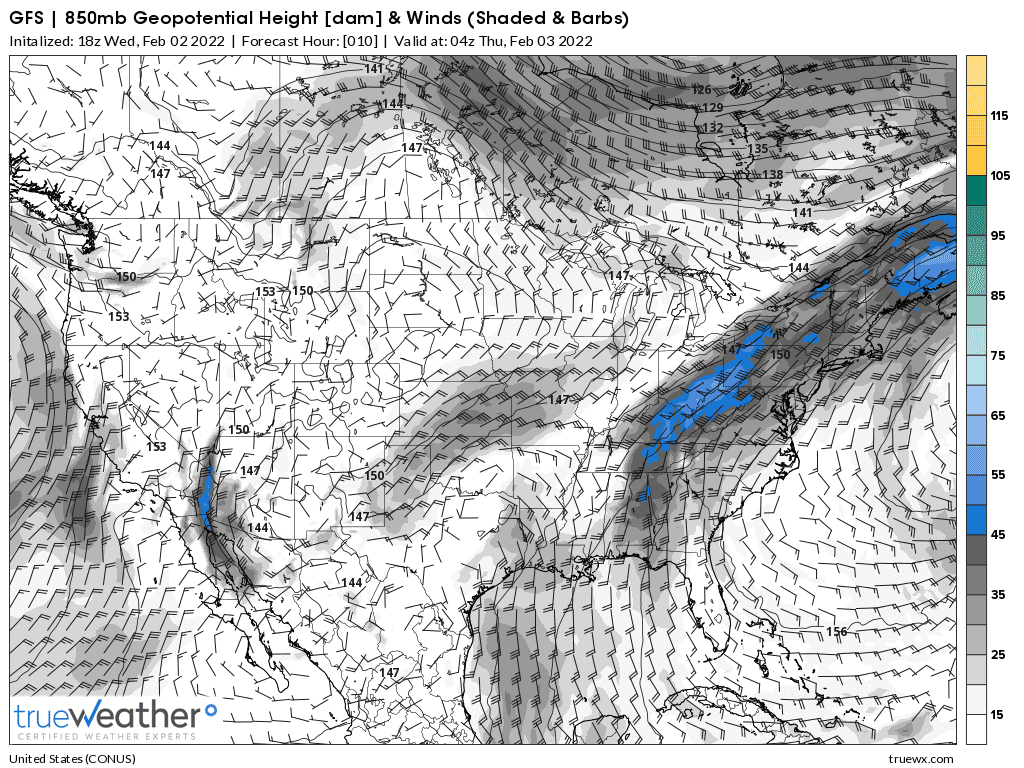
Here comes the entire problem. Surface winds below are strong out of the north, driving down subfreezing cold(purple) that's undercutting the warm, moist air at 5,000+ feet(above), deeply into w.KY/w.TN and Arkansas.
https://www.spc.noaa.gov/exper/mesoanalysis/new/viewsector.php?sector=20#
That vertical temperature profile above is causing the precipitation shield below. Note that the heavier precip with the 2nd storm has crossed much of MO and n.AR and should arrive BEFORE dawn Thursday.
https://www.wunderground.com/maps/radar/current
This is the forecast from the NWS in Evansville. This seems reasonable.
https://www.weather.gov/pah/weatherstory
10pm: The temperature has been at 31 deg. F since 8pm.
Storm 2 with the heavier precip will be moving east/northeast across MO and AR the next several hours. Should get to Evansville by dawn on Thursday.
Midnight: Down to 30 deg. F since 11pm. Cars outside are completely covered in a layer of ice that is still less than .10. All elevated surfaces too. You should lock windshield wipers up so that they are way above the windshield to prevent them from getting stuck/frozen to the car windshield.
All roads here are still just wet. Slick spots will begin shortly on bridges/overpasses, then by early morning....all roads. The heavy precip with the 2nd wave has crossed most of MO and all but far ne.AR..........destined to get here well BEFORE daybreak.
https://www.wunderground.com/maps/radar/current
1am: Down to 29 degrees.
The precip has rapidly developed well ahead of schedule and is already starting to pick up again.
The heaviest intensity should still be after sunrise though. Hopefully it changes to sleet pretty early.
2am: Up to 30 degrees. With a north wind at 10+ mph trying to blow colder air in. How did the temp go up? Apparently the warmer air aloft, at 5,000 feet with the liquid rain falling from there/picking up, warmed the surface layer below slightly.
Heaviest precip has been more to the south of Evansville and there's been alot of freezing rain with the sleet.
Now, with colder air rushing in aloft towards the end of the storm, the ice will change to snow, maybe by noon.....certainly by early afternoon with several inches of accumulation possible.
The radar shows that we should be in heavy snow and I now realize that sleet is showing up as snow and it caused me to think, in the previous posts that we would change over to snow sooner than the initial forecast.......but we are still sleet and its almost 2pm.
https://www.wunderground.com/maps/radar/current
Still sleet at 4pm.
My son lives around 6 miles south of here and they got more freezing rain and less sleet than we did.
Outside of our house, we have some sleet piles under where the sleet all slid off the roof of 13 inches.
Man, it's tough to estimate how much of what we got. Maybe be got 2 inches of sleet? and 1/2 inch of freezing rain?
It's all mixed in together.
I'll try to figure it out later.
We finally changed to snow around 4:20pm. I think the national radar today has not been operating properly.
It was down completely late yesterday evening for a couple of hours. Every NEXRAD doppler radar was down.
The snow has tapered off to a few flurries now.
Looks like Evansville got a total of 1.04 liquid equivalent from the frozen precip part of the event.
Starting at 8pm Wednesday and mostly ended at 9pm Thursday.
If that had been entirely snow, with a typical 10 to 1 snow to water equivalent, that would be 10 inches of snow.
Where you lived determined how much of what fell.
We live in McCutchansville(just north of Evansville).
The sleet to water ratio is around 2.5 to 1 ratio(1 inch of water would make 2.5 inches of sleet).
My estimate is that we got around 1.3 inches of sleet from .52 of liquid that froze on the way down.
Around .4" of ice from freezing rain........that froze AFTER hitting the ground but some of that was soaked into the sleet, which turned into into a solid layer of frozen hard sleet late this evening when the temperatures dropped well down into the 20's.
On top of that, at the end: 1 inch of snow from .1" of liquid.
Happy Weatherperson's Day! Feb 5, 2022
Started by metmike - Feb. 5, 2022, 10:54 a.m.
Celebrating National Weatherperson's Day
https://www.marketforum.com/forum/topic/81389/


