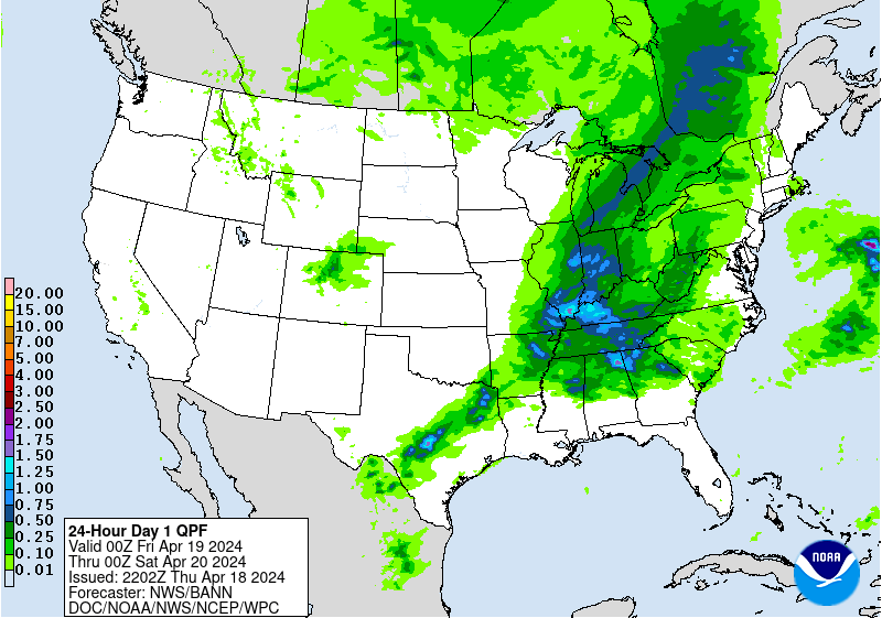
New rains emerging.............even wetter than yesterday....especially late week 1.
Forecast for rains below:
Day 1:
http://www.wpc.ncep.noaa.gov/qpf/fill_94qwbg.gif?1526306199054
 |
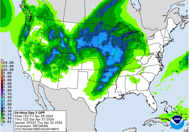
Day 2:
http://www.wpc.ncep.noaa.gov/qpf/fill_98qwbg.gif?1528293750112
 |
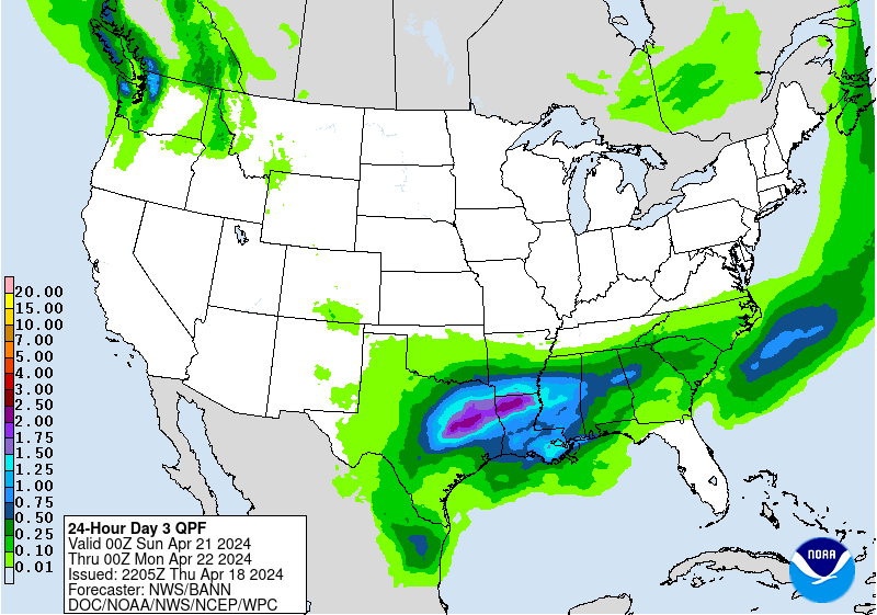
Day 3:
http://www.wpc.ncep.noaa.gov/qpf/fill_99qwbg.gif?1528293842764
 |
Days 4-5:
http://www.wpc.ncep.noaa.gov/qpf/95ep48iwbg_fill.gif?1526306162
Days 6-7:
http://www.wpc.ncep.noaa.gov/qpf/97ep48iwbg_fill.gif?1526306162
Days 4-5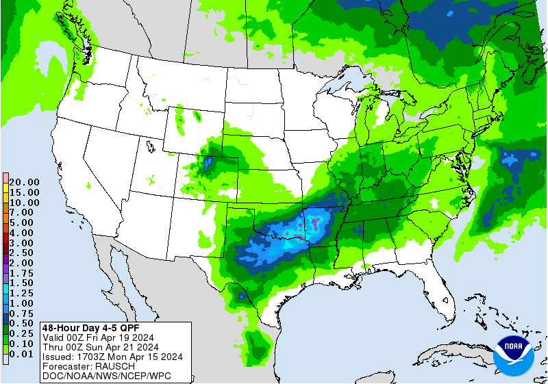 Valid 12z 07/11/18 - 12z 07/13/18 [contours only] | Days 6-7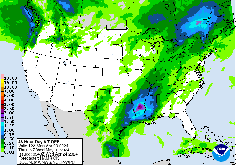 Valid 12z 07/13/18 - 12z 07/15/1 |
http://www.wpc.ncep.noaa.govcdx /qpf/p168i.gif?1530796126

Severe Storm Risk. Northern Tier. Press your cursor on the map for full screen.
https://www.spc.noaa.gov/products/outlook/
Current Day 1 Outlook | Forecaster: Hart/Kerr Issued: 18/1240Z Valid: 18/1300Z - 19/1200Z Forecast Risk of Severe Storms: Slight Risk |
Current Day 2 Outlook | Forecaster: Bunting Issued: 18/0600Z Valid: 19/1200Z - 20/1200Z Forecast Risk of Severe Storms: Marginal Risk |
Current Day 3 Outlook | Forecaster: Bunting Issued: 18/0731Z Valid: 20/1200Z - 21/1200Z Forecast Risk of Severe Storms: Marginal Risk |
Current Day 4-8 Outlook |
Not much Excessive Rainfall threat.
Current Day 1 Forecast Valid 12Z 07/05/18 - 12Z 07/06/18 |
Day 1 Threat Area in Text Format
| Day 2 and Day 3 Forecasts |
Current Day 2 Forecast |
High Temperatures today and Wednesday.


Dew points starting to increase northward.

Heat and high humidity .....feels like temperature!

Highs days 3-7 shows Hot but............cooling late, especially Upper Midwest.


How do these temperatures compare to average at this time of year. Above average in the hottest time of year!:
High temperature departures:

Low Temperature Departures:

The corn in my area looks really good. One of the fields I pass is already tasseling. Last year at this time it was barely shoulder high. For the middle of July, it's pretty impressive.
Thanks Jim!
Satellite picture.

Rains the past 24 hours. Minnesota!
![]()
You can go to this link to see rain totals from recent time periods:
https://water.weather.gov/precip/
Go to precipitation, then scroll down to pick a time frame. Hit states to get the borders to see locations better. Under products, you can hit "observed" or "Percent of normal"


Canadian ensembles back up the heat ridge in week 2 with a deepening trough in the Northeast. This has been a consistent theme for numerous days for this model with fewer and fewer members having the heat ridge farther east.
384h GZ 500 forecast valid on Jul 25, 2018 00 UTC


GFS ensembles have the same idea........Strong heat ridge Southwest, upper level trough East.

The longer range, week 3 and week 4 forecast still shows cool.

Precip below:

What's interesting here is that some of the guidance is turning hotter again in week 2:
Almost but not quite half of the Canadian model ensembles on the just updated 12z solution now bring the dome much farther east again:
384h GZ 500 forecast valid on Jul 26, 2018 12 UTC


There are a few members of the 12Z GFS ensembles that have switched to this hotter idea............a minority.

The last operational 12z GFS below was much more bullish with the upper level ridge farther east in week 2 but this is just 1 run...........we'll have to see if future runs follow or not:
 | gfs_namer_276_500_vort_ht |
gfs_namer_276_1000_500_thick | gfs_namer_276_850_temp_ht |
The NWS extended forecast moves in the direction of near normal temperatures and precip by the later period.
This extended period obviously displays less skill than the week 1 period but right now, the confidence is even lower because of the disparity in solutions at the moment.
See the above comments on the latest Canadian model.
Temperature Probability 6-10 day |
Precipitation Probability |
Temperature Probability 8-14 day | |
Precipitation Probability | |
Hey Mike,
My take on the 12Z Canadian ensemble mean: Even though the day 16 map, itself, is a bit more bullish than the 0Z day 16 map, the 12Z for days 1-15 is significantly cooler/more bearish than the 0Z run as a whole. As a matter of fact, the late week 2/11-15 day period, itself, is significantly cooler on the 12Z vs the 0Z. In the vast majority of cases based on years of following it, if the market is presented with the latest day 1-15 ensemble run, including the 11-15, itself, showing significantly fewer CDDs and IF it reacts to it, it will drop rather than rise even with a day 16 that is warmer. That makes sense as it is being presented with data that suggests the next 15 days, overall, will have significantly lower AC demand than previously thought. NG isn't going to say: "who cares about the cooler upcoming 15 day period because the much more highly speculative day 16 map suggests that after this good chance for a cooler 15 day period there is a HINT that day 16 and perhaps beyond by some unknown period will warm up. We don't know by how much or for how long or even if the day 16 change will occur." NG doesn't normally work like that nor should it from a logical standpoint imo.
I'll illustrate this with an example that is similar to this 12Z run since you liked the last one I did: let's say that days 1-15 had 10 fewer CDDs than the prior run , days 11-15 had 5 fewer, and that the more highly speculative day 16 had 1 CDD more. The market will fall in the vast majority of cases IF it reacts to this run. A much more speculative day 15 or 16 map that is warmer will not normally come even close to trumping a cooler days 1-14. The cooler days 1-14 are first dialed in via lower prices before any possible later rise should the warmer days 15-16 persist AND progress earlier in the forecast. A trader will not do well in the long run if he/she looks at day 15-16 maps (even ensemble) without also giving a lot of consideration to days 1-14.
Edit: That NWS 8-14 map you showed should be cooler than the prior forecast based strictly on the 12Z CDN ens. because it doesn't even show any warming til day 16.
hi Mike..well we watched that cold front come south all day only fall apart at our door step......really needed that one
Know how you feel mcfarm
Yesterday was hot and the crops were suffering big time
Today is cooler and the suffering is a lot less
We had 1" of rain a week-10 days ago and the soil sucked it up so you would not know it even rained
No chance until this week end
Losing bu. by the day
Just hope hail does not come with any rain
July is our hail season
Oh well
This is the new normal for us
Corn is shooting tassels and will continue according to planting date
Thanks Larry,
Everything that you stated makes good sense. I obviously spend too much time/space showing the late week 2 maps.
The latest 18z GFS ensemble average turns(much?) cooler in the 11-15 day period than the previous runs. On the day 11 map below, you can see the reason why. A very strong, upper level trough is digging thru the Upper Great Lakes with the 576 dm contour as far south as Lake Superior and well defined "kink" in the contours associated with it. The previous ensemble mean was much flatter with this feature.
As the energy from this feature feeds into the main trough, it deepens it, so that 4 days later, the 576 dm contour drops even farther south and is located close to where the 582 contour was on day 11. The 588 contour, which was around Cincinnati, OH on day 11 drops to the TN/GA border on day 15. The previous 12z run featured the 588 contour farther north.
Days 11 and 15 solutions are below:


![[contours only]](http://www.wpc.ncep.noaa.gov/qpf/95ep48iwbg.gif?1531058516)