The 8-14 day shows some hope. Some won’t make it til then. I have some new seeding that might not.
https://www.cpc.ncep.noaa.gov/products/predictions/814day/index.php
(move to trading if you would please)
mcfarmer,
This is what I've been touting in the forecast for a few days now, so I agree with the outlook but it's not high confidence.
https://www.marketforum.com/forum/topic/70329/#70906
It's the hot temperatures, with no rain as you know that's the real quick killer.
There are actually some rain chances late this week but low confidence there too.
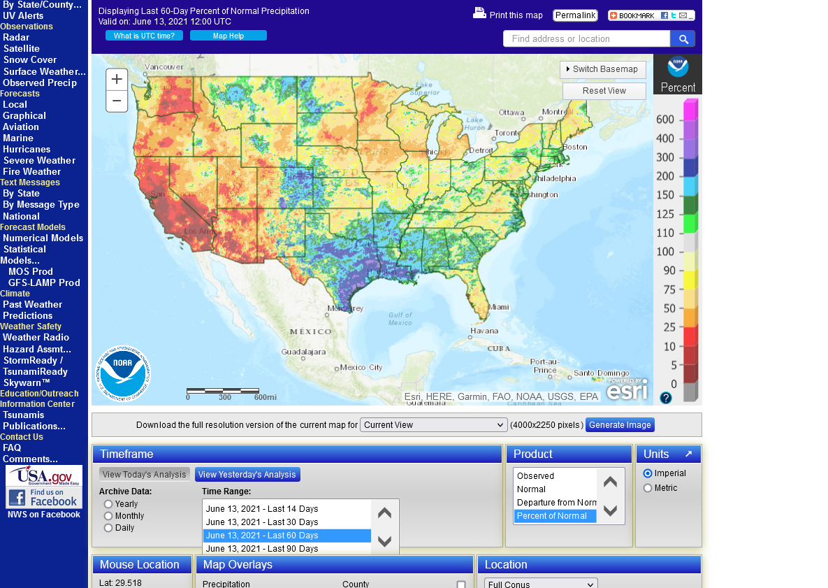
I feel for you mcfarmer from looking at the soil moisture maps........like the ones below.
Based on where I think that you are located, your soil moisture right now is in the top 5% of driest ever........the bright red shade.
The tiny patch of dark red shade, just east of you is in the top 1% of driest ever. The drought monitor is bad but doesn't look as bad. I'm thinking that it uses longer term rains and goes deeper into vertical soil moisture profile..........and you had some rains earlier in the year that helped with that metric but the top soil is all dried out pretty far down now.
![]()
Drought Monitor....long term drought.

Here's all the weather:
mcfarmer,
I added this page to explain what's going on in IA and vicinity right now.
One positive element is that the intense heat will definitely let up later this week, (at least 5 degrees cooler) regardless of how much rain falls.
But you are getting to a point where each day without rain is taking away yield that no amount of rain can bring back..............so the rains MUST get here ASAP.
https://www.marketforum.com/forum/topic/70329/#70970
This is the area burning up right now.
There was not much surplus/subsoil moisture coming in and this is the rain total for the past 2 months.
The brown is less than 50% of average rain. The bright red is less than 25% of average rain.
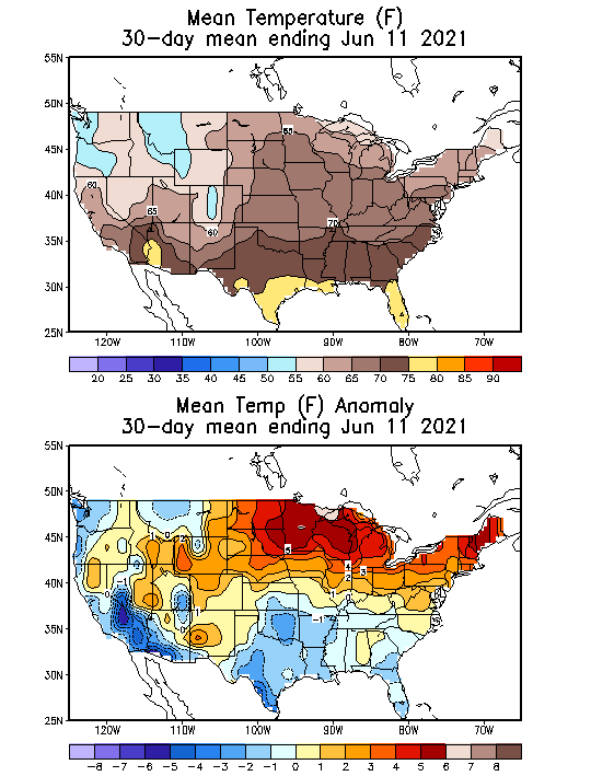
Note on the 2nd map below, the much above temperatures in the exact same area because of the heat ridge that was in that location. Cool and dry doesn't kill crops...............HOT and dry can put a big hurt on VERY quickly.
Soils dry out much faster(double the evaporation rates, with hot vs cool..especially this time of year with the high angled sun and the corn not big enough to provide a shade canopy for the soils). Transpiration rates and moisture requirements also are higher for the growing crops.
The market is believing the rains with the sharply lower open......extreme volatility.
15,000 contracts of December corn in just over 5 minutes after the open.
This is what I warned tjc about on Friday before the close....... potentially happening on Sunday Night if rains got added to the forecast.
It sort of stinks if you are a producer in IA watching your crop shrink in your backyard from the heat with no rain and watching the value of it on the board plunge at the same time.
If the forecast verifies, the highs are obviously in but the forecast can change quickly if the heat ridge is stronger in the extended or is in a different position....that is NOT the trend though.
The gaps higher from last Sunday Night are all powerful exhaustion buying, gap and crap bearish formations on the technical charts.
Just to repeat why we are down so much this evening. A big pattern change to much wetter is coming in week 2 according to the models, along with the heat ridge receding and less intense heat.
https://www.marketforum.com/forum/topic/70329/#70906
Extended weather.
https://www.cpc.ncep.noaa.gov/products/predictions/610day/ | |||||||||
| 6 to 10 day outlooks | |||||||||
| Click below for information about how to read 6-10 day outlook maps Temperature Precipitation | |||||||||
| Click below for archives of past outlooks (data & graphics), historical analogs to todays forecast, and other formats of the 6-10 day outlooks ArchivesAnalogsLines-Only FormatGIS Data | |||||||||
Temperature Probability | |||||||||
Precipitation Probability | |||||||||
Thanks very much. I would be in the panhandle of that darkest red area shaped like Florida.
Things still look good in the mornings so the plants will recover if they get a drink. By the end of the day there are many rolled planted on the lighter ground.
YW mcfarmer. Thanks for the crop report. Keep us posted and lets hope the prospects for rain continue to increase for you!

