Tropics August 17, 2020
42 responses | 0 likes
Started by metmike - Aug. 17, 2020, 2:11 p.m.

Scroll down for more!

2 new tropical waves to monitor this week with decent chances of developing to a tropical storm.

The one farther west has a 50% chance and the other one a 70% chance of becoming a storm within 5 days.


https://www.nhc.noaa.gov/


 Click for Eastern Pacific 


Active Storms | Marine Forecasts
2-Day Graphical Tropical Weather Outlook  |  5-Day Graphical Tropical Weather Outlook


Atlantic - Caribbean Sea - Gulf of Mexico
Comments
By metmike - Aug. 17, 2020, 2:15 p.m.
Like Reply


Aug. 17, 2020 – NASA Sees Former Tropical Storm Josephine Open into a Trough

https://blogs.nasa.gov/hurricanes/2020/08/

By metmike - Aug. 17, 2020, 2:17 p.m.
Like Reply

'Extremely active' hurricane season possible for Atlantic Basin


https://www.noaa.gov/media-release/extremely-active-hurricane-season-possible-for-atlantic-basin


"The 2020 Atlantic hurricane season has been off to a rapid pace with a record-setting nine named storms so far and has the potential to be one of the busiest on record. Historically, only two named storms form on average by early August, and the ninth named storm typically does not form until October 4. An average season produces 12 named storms, including six hurricanes of which three become major hurricanes (Category 3, 4, or 5).

“This is one of the most active seasonal forecasts that NOAA has produced in its 22-year history of hurricane outlooks"

The updated 2020 Atlantic hurricane season probability and numbers of named storms.

The updated 2020 Atlantic hurricane season probability and numbers of named storms. (NOAA)


The 2020 Atlantic tropical cyclone names selected by the World Meteorological Organization.

The 2020 Atlantic tropical cyclone names selected by the World Meteorological Organization. (NOAA)


By metmike - Aug. 17, 2020, 2:26 p.m.
Like Reply


How Do Hurricanes Form?

https://spaceplace.nasa.gov/hurricanes/en/


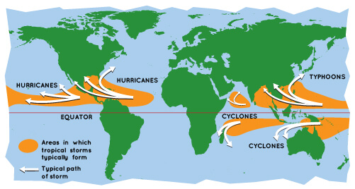
Whatever they are called, tropical cyclones all form the same way.

World map showing area where cyclones occur.


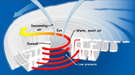
Tropical cyclones are like giant engines that use warm, moist air as fuel. 


Tropical cyclone cross-section

If you could slice into a tropical cyclone, it would look something like this.  The small red arrows show warm, moist air rising from the ocean's surface, and forming clouds in bands around the eye.  The blue arrows show how cool, dry air sinks in the eye and between the bands of clouds.  The large red arrows show the rotation of the rising bands of clouds.


Tropical cyclone categories:

CategoryWind Speed (mph)Damage at LandfallStorm Surge (feet)
174-95Minimal4-5
296-110Moderate6-8
3111-129Extensive9-12
4130-156Extreme13-18
5157 or higherCatastrophic19+


By metmike - Aug. 17, 2020, 2:36 p.m.
Like Reply

metmike: In 2020, so far we have been setting records for so many early named storms.

The earliest for the L named storm, next one up in 2020 is August 29th, 1995. We should be able to beat that one easily.


We could go on to challenge the 2005 record for most named storms., 28. That year, we had to go out 6 additional names beyond the designated pre season names.


List of Atlantic hurricane records

https://en.wikipedia.org/wiki/List_of_Atlantic_hurricane_records


  Indicates a tie for the earliest/next earliest formation date

 Based on data from: U.S. NOAA Coastal Service Center - Historical Hurricane
NameDate of formationNameDate of formation
Storm #EarliestNext earliest
Earliest formation of north Atlantic tropical cyclones by storm number
1UnnamedJanuary 3, 1938UnnamedJanuary 4, 1951
2UnnamedMay 17, 1887UnnamedMay 26, 1908
BerylMay 26, 2012
3CristobalJune 2, 2020ColinJune 5, 2016
4DanielleJune 20, 2016DebbyJune 23, 2012 (12z)
5EdouardJuly 6, 2020EmilyJuly 11, 2005
6FayJuly 9, 2020FranklinJuly 21, 2005
7GonzaloJuly 22, 2020GertJuly 24, 2005
8HannaJuly 24, 2020HarveyAugust 3, 2005
9IsaiasJuly 30, 2020IreneAugust 7, 2005
10JosephineAugust 13, 2020JoseAugust 22, 2005
11KyleAugust 14, 2020KatrinaAugust 24, 2005
12LuisAugust 29, 1995LeslieAugust 30, 2012
13MariaSeptember 2, 2005MichaelSeptember 4, 2012
LeeSeptember 2, 2011
14NateSeptember 5, 2005MariaSeptember 7, 2011
15OpheliaSeptember 7, 2005 (06z)UnnamedSeptember 19, 1936
16PhilippeSeptember 17, 2005OpheliaSeptember 21, 2011
17RitaSeptember 18, 2005PhilippeSeptember 24, 2011
18StanOctober 2, 2005SebastienOctober 21, 1995
19UnnamedOctober 4, 2005TonyOctober 24, 2012
20TammyOctober 5, 2005UnnamedNovember 15, 1933
21VinceOctober 9, 2005N/A
22WilmaOctober 17, 2005N/A
23AlphaOctober 22, 2005N/A
24BetaOctober 27, 2005N/A
25GammaNovember 18, 2005N/A
26DeltaNovember 23, 2005N/A
27EpsilonNovember 29, 2005N/A
28ZetaDecember 30, 2005N/A


By metmike - Aug. 17, 2020, 2:41 p.m.
Like Reply

https://en.wikipedia.org/wiki/List_of_Atlantic_hurricane_records


Most intense by minimum barometric pressure

Most intense Atlantic hurricanes
HurricaneSeasonBy peak pressureBy pressure at landfall
hPainHghPainHg
Wilma200588226.05
Gilbert198888826.2390026.58
"Labor Day"193589226.3489226.34
Rita200589526.43
Allen198089926.55
Camille196990026.5890026.58
Katrina200590226.64
Mitch199890526.73
Dean200790526.7390526.73
Maria201790826.81
"Cuba"1924
91026.87
Dorian2019
91026.87
Janet1955
91426.99
Irma2017
91426.99
"Cuba"1932
91827.02
Michael2018
91927.14

+++++++++++++++++++++++++++++++++++++++++++++++++++++++


Hurricanes do more costly damage because there is more expensive stuff in their paths!


RankHurricaneSeasonDamage[nb 7]
Costliest Atlantic hurricanes
1Katrina2005$125 billion
Harvey2017
3Maria2017$91.6 billion
4Irma2017$77.2 billion
5Sandy2012$68.7 billion
6Ike2008$38 billion
7Wilma2005$27.4 billion
8Andrew1992$27.3 billion
9Ivan2004$26.1 billion
10Michael2018$25.1 billion
By metmike - Aug. 17, 2020, 2:47 p.m.
Like Reply

Hurricane trend detection


https://wattsupwiththat.com/2020/08/15/hurricane-trend-detection/


Abstract


"Because a change in the frequency (number/year) of hurricanes could be a result of climate change, we analyzed the historical record of Atlantic basin and US landfalling hurricanes, as well as US continental accumulated cyclone energy to evaluate issues related to trend detection. 


Hurricane and major hurricane landfall counts exhibited no significant overall trend over 167 years of available data, nor did accumulated cyclone energy over the continental USA over 119 years of available data, although shorter-term trends were evident in all three datasets."


                Smoking Gun!            

                            5 responses |               

                Started by metmike - Aug. 14, 2020, 6:20 p.m.            

https://www.marketforum.com/forum/topic/57636/

By wxgrant - Aug. 17, 2020, 5:20 p.m.
Like Reply

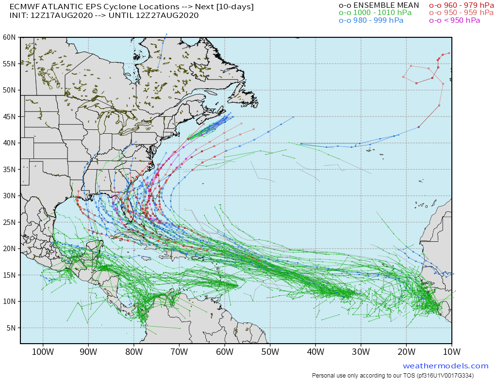
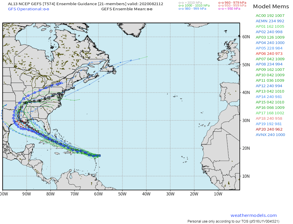
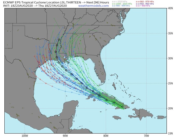
Here is the EURO Ensembel Spaghetti plots. A few of the members are bringing a pretty strong system into the Gulf from the disturbance east of the Windward Islands. 

By metmike - Aug. 17, 2020, 7:45 p.m.
Like Reply

Thanks Grant!


Could be a wild next couple of months in the tropics.

By metmike - Aug. 19, 2020, 4:38 p.m.
Like Reply
By wxgrant - Aug. 21, 2020, 5:10 p.m.
Like Reply

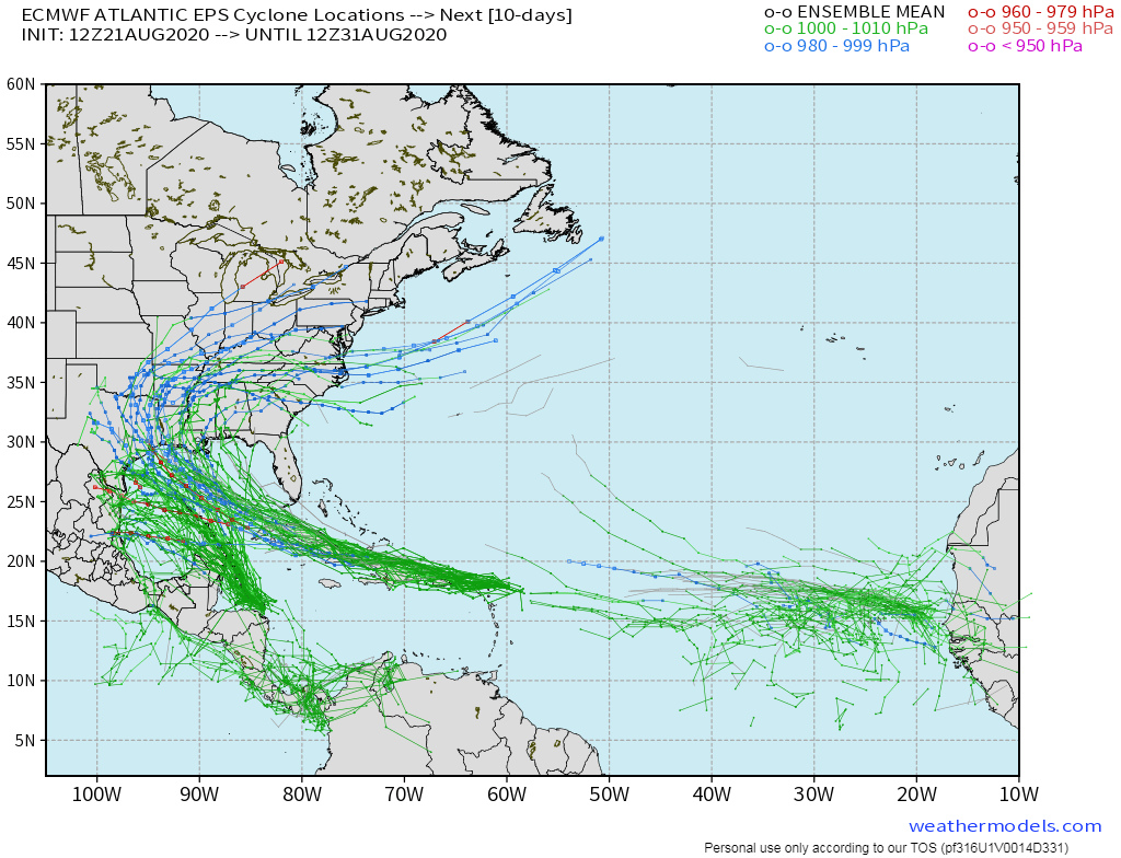
Here is the latest EURO Ensembles. It continues to push Laura farther south keeping across Cuba then developing into a stronger system before hitting the coast along Texas or Louisiana. I know there has been a lot of talk about there being to Hurricanes in the Gulf for the first time in recorded history.  I have to take the wait and see approach to that as there is a reason that doesn't happen. You would think one would cause enough shear to weaken the other. We shall see. 

By wxgrant - Aug. 21, 2020, 5:38 p.m.
Like Reply

Here is what the GFS Ensembles are showing, which did well with our last system. It too is pushing Laura it farther south and west and then making it stronger across the northwestern Gulf, very similar to the EURO. 

By metmike - Aug. 21, 2020, 7:34 p.m.
Like Reply

Thanks Grant!

It does look like a good chance for 2 minimal hurricanes to exist simultaneously in the Gulf of Mexico for a period late Monday. 

TD 14 on the left, will be named Tropical Storm Marco.

Both are predicted to top out with winds of 75 mph just before hitting land. Marco on Monday and Laura on Wednesday. 


https://www.ksat.com/weather/2020/08/21/have-there-ever-been-two-hurricanes-in-the-gulf-of-mexico-at-the-same-time/

The forecast tracks for Tropical Depression Fourteen and Tropical Storm Laura; Valid Friday, August 21st


By metmike - Aug. 21, 2020, 7:40 p.m.
Like Reply

https://www.ksat.com/weather/2020/08/21/have-there-ever-been-two-hurricanes-in-the-gulf-of-mexico-at-the-same-time/

Have there ever been two hurricanes in the Gulf of Mexico at the same time?

No. The closest seems to be on Sept 4, 1933, when a major hurricane was over south Florida and another major hurricane was over the western Gulf of Mexico.


When is the last time two tropical cyclones were in the Gulf of Mexico simultaneously?

September 5-6, 2002

  • Tropical Storm Fay (in the northwest Gulf of Mexico)
  • Tropical Depression Edouard (weakened after crossing Florida from east to west)
  • Overlap was about 18 hours

June 17-18, 1959

  • Tropical Storm Beulah (made landfall well south of the US-Mexican border)
  • Hurricane 3 (was a tropical storm in the Gulf, before crossing the Florida Peninsula and intensifying over the Atlantic)
  • Overlap was about 8 hours

When is the last time that two tropical cyclones in the Gulf of Mexico simultaneously directly affected the United States mainland?

September 4, 1933

  • Hurricane 8 (landfall in deep South Texas as a major hurricane)
  • Hurricane 11 (Hurricane 11 weakened to a tropical storm after crossing the Florida Peninsula and briefly entered the Gulf of Mexico near Cedar Key, Florida)
  • Overlap was very brief, about 4 hours

There was one more recent case in 1974 where a tropical depression and subtropical storm occurred at the same time: June 24-25, 1974

  • Tropical Depression 1 (formed in Bay of Campeche)
  • Subtropical Storm 1 (rapidly moved west-to-east toward, and eventually across, the Florida Peninsula)
  • Overlap was about 12 hours (18Z 24 Jun 1974 to 06Z 25 Jun 1974)

Were there any other near misses in the recent past?

Yes, two in the satellite era. In 2004, Tropical Storm Bonnie made landfall in the Florida Panhandle about 16 hours before Hurricane Charley emerged into the Gulf after passing over Cuba. In 1971, Fern made landfall as a tropical storm in Texas about 24 hours before Edith emerged into the Bay of Campeche as a tropical storm after crossing the Yucatan Peninsula.

Has there ever been two hurricanes that make landfall in the mainland U.S. within days of each other?

Yes, although rare, there have been 10 instances of the United States having hurricane landfalls within 5 days of each other. (1869, 1879, 1893, 1903, 1933, 1940, 1949, 1960, 2004, 2005)

In 1933, Hurricanes #8 and #11 (storms were not named then) made landfall within one day of each other, striking Texas and Florida.

By metmike - Aug. 21, 2020, 7:45 p.m.
Like Reply


Fujiwhara Effect

https://www.weather.gov/news/fujiwhara-effect

When two hurricanes spinning in the same direction pass close enough to each other, they begin an intense dance around their common center. If one hurricane is a lot stronger than the other, the smaller one will orbit it and eventually come crashing into its vortex to be absorbed. Two storms closer in strength can gravitate towards each other until they reach a common point and merge, or merely spin each other around for a while before shooting off on their own paths. In rare occasions, the effect is additive when the hurricanes come together, resulting in one larger storm instead of two smaller ones.

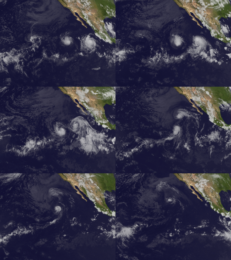
One example of this (below) was between hurricanes Hilary and Irwin in the East Pacific in 2017.

GOES-16 satellite imagery over the eastern Pacific Ocean from July 25 to August 1. Hurricane Irwin on the left collided with Hurricane Hilary on the right; the two merged before fading out over the ocean.


BUT... The National Hurricane Center states: There’s nothing “usual” about this type of interaction in the Atlantic basin. More often than not, the storms deflect around each other, or the larger storm destroys the other one. It is quite rare to have a perfect combination to form “a larger hurricane”

By metmike - Aug. 22, 2020, 11:59 a.m.
Like Reply


metmike:  You can see from the  forecast graphics below, that Marco and Laura are predicted to hit in close to the same place.........Laura a bit farther east and a couple of days later. There still could be a brief period when both are minimal hurricanes that they are both in the GOM. 

Usually, a hurricane that tracks in the wake of a previous hurricane within a week or so, tracks into a sea surface environment that was subjected to up-welling of cooler water at some depth to the surface because of churning that resulted from the first hurricane.

The NHC says that Marco will be a small enough hurricane so as to not have that be a major factor. I would still think that it could play a role. 

++++++++++++++++++++++++++++++++++++++++


[Key Messages]


[Key Messages]


By metmike - Aug. 22, 2020, 12:11 p.m.
Like Reply

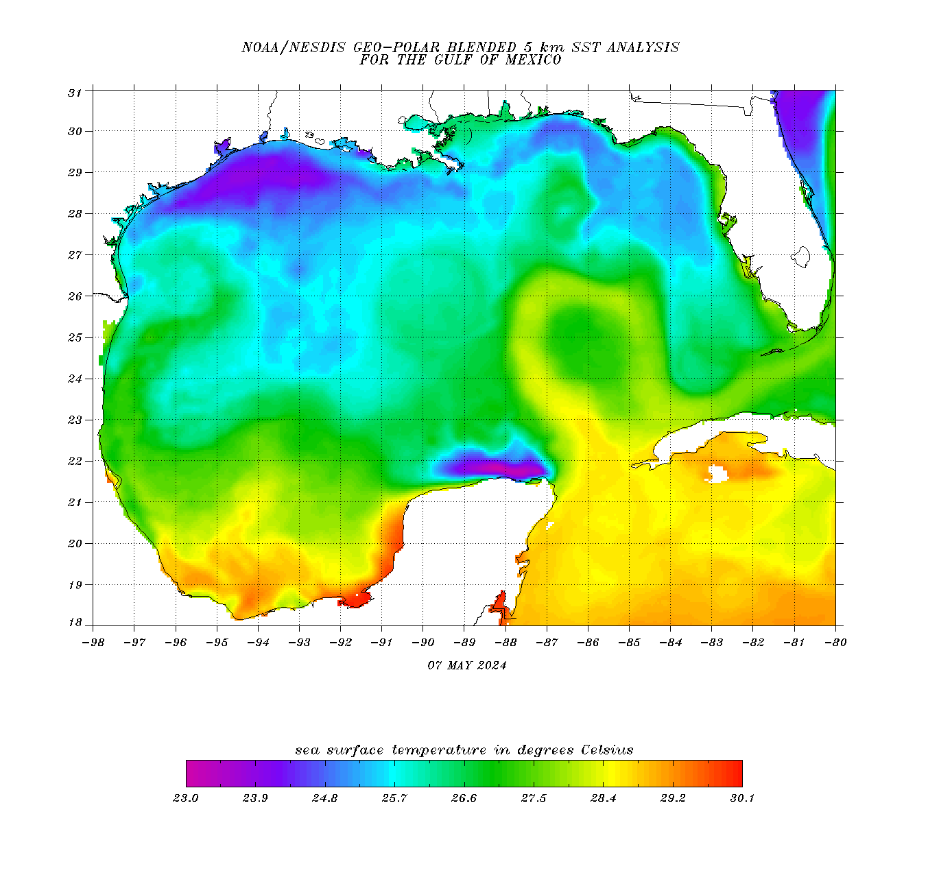
Current water temperatures in the Western Gulf are VERY warm.


30 deg. C is 86 deg. F.

80+ deg. is the temp we want to see to sustain a hurricane.  Looks like there are some spots in the W.GOM right now that are in the U-80's!

That's getting pretty hot and potentially some extra octane for a hurricane. 


https://www.ospo.noaa.gov/data/sst/contour/gulfmex.cf.gif

https://www.ospo.noaa.gov/data/sst/contour/gulfmex.cf.gif


By metmike - Aug. 22, 2020, 12:21 p.m.
Like Reply

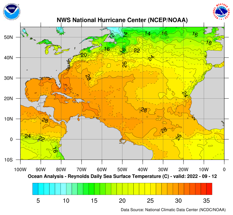
Use the link below to see the 7 day anomaly loop. Temps are a bit above average thru, almost the entire Atlantic Basin right now.


https://www.nhc.noaa.gov/tafb/sst_loop/14_atl.pnghttps://www.nhc.noaa.gov/tafb/atl_anom.gif


https://www.nhc.noaa.gov/sst/rsst_atl_anom_loop.php

By metmike - Aug. 23, 2020, 6:47 p.m.
Like Reply

There probably won't be 2 hurricanes at the same time in the Gulf.

Marco is a min hurricane right now and will continue at this level the next 24 hours before hitting around the coast of LA late Monday.

Then drift wesward into TX and die out.

Laura won't strengthen enough to become a hurricane until Tuesday, after Marco has made landfall but will be tracking across some very warm waters and a favorable environment after that, so rapid strengthening, possibly close to a major hurricane will take place.

Laura also hits LA....on Wednesday with much more impact than Marco.

Then, Laura tracks northward, possibly as far north as the southern Ohio River Valley on Friday.

By metmike - Aug. 23, 2020, 10:07 p.m.
Like Reply

Ryan Maue Retweeted

Dylan Federico@DylanFedericoWX

·

18z EURO ensembles offer little clarity, with a huge spread in #LAURA’s potential track in the Gulf of Mexico. The strongest members (major hurricane) are furthest south & west, tracking towards Texas.Cyclone Everyone from Texas to Louisiana needs to be alert. #TropicalUpdateImage

By metmike - Aug. 24, 2020, 12:38 p.m.
Like Reply

This is the same link as the one at the top of the page.........the main link to the NHC to get the latest.

1. Marco is a weakening tropical storm.

2. All eyes are on Laura now. It should become a hurricane on Tuesday.

3. It could potentially strengthen close to a major hurricane on Wednesday.

4. It should hit, around the W.LA coast on Wednesday Night.

5. The remnants will track, as far north as the S.Ohio Valley on Friday.


https://www.nhc.noaa.gov/


 Click for Eastern Pacific 


Active Storms | Marine Forecasts
2-Day Graphical Tropical Weather Outlook  |  5-Day Graphical Tropical Weather Outlook


Atlantic - Caribbean Sea - Gulf of Mexico


By metmike - Aug. 24, 2020, 1:48 p.m.
Like Reply

This is the earliest in the season to ever get to the letter M(13th storm of 2020) which is Marco.

The previous earliest, was September 2, 2005, with Maria.


Wait a second, you might be thinking. Maria was a monster hurricane in 2017!!


This is true but Maria in 2005, was a wimp, so the name got recycled. Then, Maria in 2011 was a wimp, so the name got recycled. Then Maria in 2017 was a monster............so the name was retired forever.

The M name in 2023, that replaces Maria is Margot.

https://www.nhc.noaa.gov/aboutnames.shtml

Atlantic Names

Atlantic Pronunciation Guide (PDF)

202020212022202320242025
Arthur
Bertha
Cristobal
Dolly
Edouard
Fay
Gonzalo
Hanna
Isaias
Josephine
Kyle
Laura
Marco
Nana
Omar
Paulette
Rene
Sally
Teddy
Vicky
Wilfred
Ana
Bill
Claudette
Danny
Elsa
Fred
Grace
Henri
Ida
Julian
Kate
Larry
Mindy
Nicholas
Odette
Peter
Rose
Sam
Teresa
Victor
Wanda
Alex
Bonnie
Colin
Danielle
Earl
Fiona
Gaston
Hermine
Ian
Julia
Karl
Lisa
Martin
Nicole
Owen
Paula
Richard
Shary
Tobias
Virginie
Walter
Arlene
Bret
Cindy
Don
Emily
Franklin
Gert
Harold
Idalia
Jose
Katia
Lee
Margot
Nigel
Ophelia
Philippe
Rina
Sean
Tammy
Vince
Whitney
Alberto
Beryl
Chris
Debby
Ernesto
Francine
Gordon
Helene
Isaac
Joyce
Kirk
Leslie
Milton
Nadine
Oscar
Patty
Rafael
Sara
Tony
Valerie
William
Andrea
Barry
Chantal
Dorian
Erin
Fernand
Gabrielle
Humberto
Imelda
Jerry
Karen
Lorenzo
Melissa
Nestor
Olga
Pablo
Rebekah
Sebastien
Tanya
Van
Wendy


Since 1953, Atlantic tropical storms had been named from lists originated by the National Hurricane Center. They are now maintained and updated through a strict procedure by an international committee of the World Meteorological Organization.

The six lists above are used in rotation and re-cycled every six years, i.e., the 2019 list will be used again in 2025. The only time that there is a change in the list is if a storm is so deadly or costly that the future use of its name on a different storm would be inappropriate for reasons of sensitivity.  If that occurs, then at an annual meeting by the WMO committee (called primarily to discuss many other issues) the offending name is stricken from the list and another name is selected to replace it. Several names have been retired since the lists were created. Here is more information the history of naming tropical cyclones and retired names.

If a storm forms in the off-season, it will take the next name in the list based on the current calendar date. For example, if a tropical cyclone formed on December 28th, it would take the name from the previous season's list of names. If a storm formed in February, it would be named from the subsequent season's list of names.

In the event that more than twenty-one named tropical cyclones occur in the Atlantic basin in a season, additional storms will take names from the Greek alphabet.

Can I have a tropical cyclone named for me?


By metmike - Aug. 24, 2020, 2:08 p.m.
Like Reply

metmike: From the insurance industry:

Facts + Statistics: Hurricanes

https://www.iii.org/fact-statistic/facts-statistics-hurricanes


Estimated Insured Losses For The Top 10 Historical Hurricanes Based On Current Exposures (1)          


($ billions)

RankDateEventCategory2017 insured loss
1Sep. 18, 1926Great Miami Hurricane4$128
2Sep. 17, 1928Okeechobee Hurricane478
3Aug. 29, 2005Hurricane Katrina3 (2)64
4Sep. 17, 19471947 Fort Lauderdale Hurricane462
5Sep. 9, 1965Hurricane Betsy4 (2)57
6Aug. 24, 1992Hurricane Andrew556
7Sep. 10, 1960Hurricane Donna450
8Sep. 21, 1938The Great New England Hurricane350
9Sep. 9, 19001900 Galveston Hurricane449
10Aug. 17, 19151915 Galveston Hurricane325

(1) Modeled loss to property, contents and business interruption and additional living expenses for residential, mobile home, commercial and auto exposures as of end-2016. Losses include demand surge and account for storm surge.
(2) Strength at second landfall in Louisiana.

Source: AIR Worldwide Corporation.


Top Coastal Counties Most Frequently Hit By Hurricanes: 1960-2008          


County StateCoastline regionNumber of
hurricanes
Percent change
in population,
1960-2008
Monroe CountyFloridaGulf of Mexico1550.8%
Lafourche ParishLouisianaGulf of Mexico1467.2
Carteret CountyNorth CarolinaAtlantic14104.3
Dare CountyNorth CarolinaAtlantic13465.9
Hyde CountyNorth CarolinaAtlantic1310.1
Jefferson ParishLouisianaGulf of Mexico12108.9
Palm Beach CountyFloridaAtlantic12454.7
Miami-Dade CountyFloridaAtlantic11156.5
St. Bernard ParishLouisianaGulf of Mexico1117.2
Cameron ParishLouisianaGulf of Mexico114.8
Terrebonne ParishLouisianaGulf of Mexico 1178.7

Source: U.S. Department of Commerce, Census Bureau, Decennial Census of Population and Housing: 1960 to 2000; Population Estimates Program: 2008.

By metmike - Aug. 24, 2020, 3:02 p.m.
Like Reply
By metmike - Aug. 24, 2020, 3:04 p.m.
Like Reply

Record rainfall from tropical systems..................Laura is moving much too fast to set any rainfall records. 

Amounts might approach 10 inches in isolated places of LA.

https://en.wikipedia.org/wiki/List_of_wettest_tropical_cyclones_in_the_United_States#/media/File:TCstaterainfall.gif


Map showing the highest rainfall totals measured in certain regions of the continental United States as of 2018.

By metmike - Aug. 25, 2020, 12:59 p.m.
Like Reply

Laura was just upgraded to a hurricane.


The intensity of Laura has been increased to 115 mph, which is a cat. 3 major hurricane. It should get stronger.


Looks like it will hit right around the LA/TX border, slightly farther west than the prediction from yesterday....and stronger.

It's moving fast enough so that excessive rains are not the biggest threat..............like we saw with Harvery-2017-60 inches of rain in TX and Florence-2018-36 inches of rain in NC.


10 inches of rain is a lot but for a tropical system, is not excessive. Winds will be a bigger threat.


https://www.nhc.noaa.gov/refresh/graphics_at3+shtml/153403.shtml?cone#contents

https://www.nhc.noaa.gov/text/refresh/MIATCDAT3+shtml/251505.shtml?


By metmike - Aug. 26, 2020, 12:26 p.m.
Like Reply


Laura continues to get more impressive on forecasts as it tracks over the VERY warm waters and ideal environment.

https://www.nhc.noaa.gov/graphics_at3.shtml?start#contents

Now at 125 mph and predicted to hit 145 mph later today before hitting the coast late tonight, along the LA/TX border.

This is well into a cat. 4 hurricane and 35 mph stronger than needed to be a major hurricane. 


Tropical cyclone categories:

CategoryWind Speed (mph)Damage at LandfallStorm Surge (feet)
174-95Minimal4-5
296-110Moderate6-8
3111-129Extensive9-12
4130-156Extreme13-18
5157 or higherCatastrophic19+


By metmike - Aug. 26, 2020, 2:27 p.m.
Like Reply

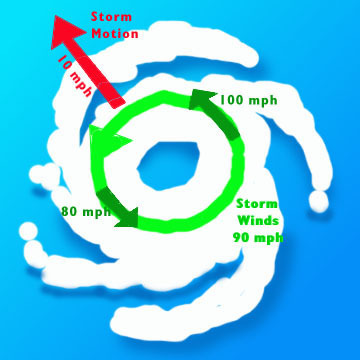
Areas to the east/right of Laura(the dirty side of the hurricane) because of the counterclockwise spin, will  have the speed of the storm adding to the velocity of the wind.

If Laura is traveling at 10 mph for instance, we add 10 mph to the hurricane winds on its east side/right side with respect to the ground/ocean. So a 130 mph gust actually becomes a 140 mph gust.

This will be just east of the TX/LA border, depending exactly on landfall.

The graphic below illustrates the increase in wind speed on the right side of a hurricane. 

Image result for right side of hurricane adds to winds graphic


By metmike - Aug. 26, 2020, 2:29 p.m.
Like Reply

This  is where the storm surge is greatest...........close to the same place where the highest winds take place.

http://tornado.sfsu.edu/geosciences/classes/m302/Hurricanes/StormSurge/StormSurge.jpg

http://tornado.sfsu.edu/geosciences/classes/m302/Hurricanes/StormSurge/StormSurge.jpg

By metmike - Aug. 26, 2020, 6:10 p.m.
Like Reply

The latest update has Laura at 145 mph, peaking at 150 mph this evening.

This is a high end cat. 4 hurricane, with cat. 5 starting at 156 mph. 

Laura is moving fairly quickly at around 15 mph. This is good for limiting the rain amounts/flooding but the forward speed will add to the winds on the right side of the tropical system.

So a 145 mph wind gust embedded in the circulation has an additional 15 mph of velocity because the system itself is moving at 15 mph with respect to the land/water.

That means it becomes a 160 mph wind gust.

The cat rating of a hurricane is based on SUSTAINED wind speeds not gusts. So there can be cat. 5 type wind gusts embedded in a cat. 4 hurricane. 

The rating of a hurricane does NOT take into account the added or subtracted wind speeds based on the movement/speed of the entity.


Also, Laura will maintain some identity as it rapidly tracks north, then northeast, then east to the Mid Atlantic Coast. The fast movement will keep rains from being excessive, however it will add to wind speeds circulating around the center on the RIGHT SIDE of the remnants.

So winds in the circulation will be down to 30 mph but if the speed is racing northeast at 20 mph, we could see some 50 mph winds to the right of the center. This is close to a damaging, straight line wind...........without any thunderstorms in the vicinity. 

Also, Laura could re intensify a bit off the East Coast and affect the Northeast with some high winds and surf this weekend(as well as the rains).


By Jim_M - Aug. 26, 2020, 7:28 p.m.
Like Reply

Thanks for taking the time and sharing your analysis with us Mike!

By metmike - Aug. 26, 2020, 9:10 p.m.
Like Reply

YW Jim!

By wxgrant - Aug. 26, 2020, 9:59 p.m.
Like Reply

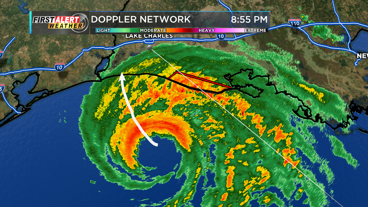
Current radar out of Lake Charles. Very scary situation for the coast. Pressure appears to be dropping so we may see a brief Cat 5 but just off shore there is a little shear. Hopefully this will allow Laura to start weakening but it will be too little too late. 

By wxgrant - Aug. 26, 2020, 10:23 p.m.
Like Reply

Latest recon has the surface pressure about 4mb lower. Might see 155MPH at the next update. Doesn't seem low enough at this time for 160MPH. 

By wxgrant - Aug. 26, 2020, 10:57 p.m.
Like Reply

Latest Pressure from a plane that just went through the center was 939mb. Hope that trend continues. 

By metmike - Aug. 26, 2020, 11:51 p.m.
Like Reply

Thanks much Grant!


Last update is 150 mph and looking like its about topped out.

Those are sustained winds, so gusts are probably higher, especially on the right side, where the 15 mph forward speed adds to the 150 mph to cause winds to be 165 mph with respect to the water.

Friction over land and lack of warm ocean water fuel will kill the hurricane force winds over a 16-20 hour period or so after it hits land but destructive winds will be felt 100 miles inland(especially with the forward speed adding to circulation winds on the right side).

I would not be surprised to still see 50 mph wind gusts on the right side even as it tracks over KY Fri Night.

By metmike - Aug. 27, 2020, 1:27 a.m.
Like Reply
Well defined eye about to come onshore here at 12:30pm CDT(starting in less than 10 minutes or so).


https://radar.weather.gov/Conus/southmissvly_loop.php


Base Reflectivity

Full resolution version loop (3400x1700 pixels - 2.2mb)


Southern Mississippi Valley sector loop
Go to: Most Recent Image


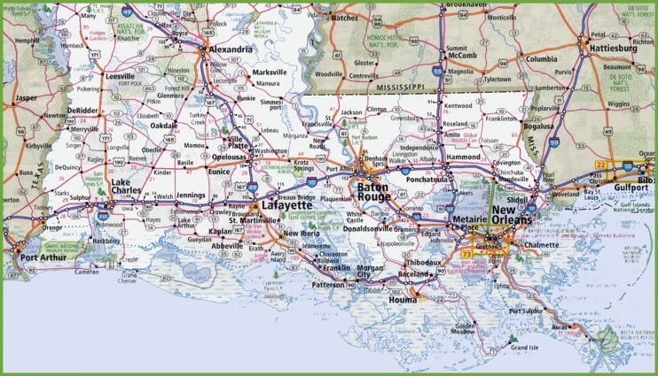
http://ontheworldmap.com/usa/state/louisiana/map-of-southern-louisiana.html

Map of Southern Louisiana

Looks like Cameron, LA to points just east of that will be clobbered with the worst wind and storm surge.

+++++++++++++++++++++++++++++++++++++++++++++++++++

Lake Charles, LA Radar

https://radar.weather.gov/radar.php?rid=lch&product=N0R&overlay=11101111&loop=yes

By metmike - Aug. 27, 2020, 1:50 a.m.
Like Reply

The northern part of the eye(with its rainfree signature) has come ashore and is over Cameron LA just at 12:49pm. 

There must be tens of thousands of people viewing this radar image right now:


https://radar.weather.gov/radar.php?rid=lch&product=N0R&overlay=11101111&loop=yes


https://www.weather.gov/lch/


By metmike - Aug. 27, 2020, 2:05 a.m.
Like Reply

Isobars analysis.

Surface


Temp/DP/wind/sky conditions above.


By metmike - Aug. 27, 2020, 1:50 p.m.
Like Reply

Laura has continued to weaken this morning and is just now dropped back down to just a tropical storm in northwest LA..about to enter AR.

The fast movement, currently at 17 mph as expected is limiting the rain totals based on tropical system standards.

It's going to add to winds though as the remnants track ne then east from Northeast AR very early Fri, then across KY on Friday. Winds circulating around Leftover Laura will still be 30 mph, so add almost 20 mph from the speed of the entire system and you get some winds that could go above 50 mph, especially in gusts. Severe thunderstorms have winds of 58+ mph. 

Those higher winds will be to the RIGHT of the track, where the forward speed ADDS to the velocity. 

By  late Sat, the remnants will be off the Mid Atlantic Coast and possibly strengthen back to around 50 mph off the coast, moving northeast to the W.Atlantic with gusty winds and high surf in the Northeast....but nothing major.

00x1700 pixels - 2.2mb)
 

Southern Mississippi Valley sector loop
Go to: Most Recent Image

By metmike - Aug. 27, 2020, 5:34 p.m.
Like Reply

A big reason for why Louisiana dodged a much more damaging hurricane bullet is that the track of Laura, was such that the strongest winds, on the right side of the storm’s center, occurred just east, then north of Cameron, LA.

This is mainly just unpopulated marshland for 40+ miles inland.

There were also no anemometers/weathers instruments in the marshes, so we don’t know what the highest winds gusts were there.

The fact that we got a 134 mph wind gust NORTH of these marshes, at lake charles,before the anemometer failed,  suggests winds were even higher there.

It appears that if you add up all the people that had power out in LA, TX and AR, the number is close to 1 million. 

There was some major structural damage to many thousands of buildings too, along with trees and power lines down...........so this was bad but just not nearly as bad as was forecast on Wednesday.


The NHC used the term Unsurvivable to describe the  affects of the storm surge. First time they used that verbiage. 

In retrospect, that was a bit over the top considering the storm surge stayed below 10 feet and rains were not excessive and wind damage was bad but most places were survivable, even with the higher winds.

I get that they wanted everybody to evacuate but in all the locations that turned out to be  very survivable and some areas to the west that had MUCH LESS damage than expected, you will have a lot of people skeptical when they see that term used again.

By metmike - Aug. 28, 2020, 1:45 p.m.
Like Reply

Winds have been gusting up to 50 mph today, especially to the right of the track of the remnants of Laura, now a tropical depression.


Southern Mississippi Valley sector loop
Go to: Most Recent Image

National
Radar
Mosaic
Sectors
Loops

(click image)
Go to the Alaska sector loopGo to the Pacific Northwest sector loopGo to the Northern Rockies sector loopGo to the Upper Mississippi Valley sector loopGo to the Central Great Lakes sector loop


Central Great Lakes sector loop
Go to: Most Recent Image

National
Radar
Mosaic
Sectors
Loops

(click image)
Go to the Alaska sector loopGo to the Pacific Northwest sector loopGo to the Northern Rockies sector loopGo to the Upper Mississippi Valley sector loopCurrently at the Central Great Lakes sector loop


By metmike - Aug. 29, 2020, 2:47 p.m.
Like Reply

The remnants of Laura were absorbed into a storm/low pressure system in the Northeast here early on Saturday.


Doppler Radar National Mosaic Loop
Go to: Most Recent Image