Rains falling farther east/southeast today..........been drying up as they get deeper into IN but not for long.
National Radar Loop:
MUCH more action than in recent weeks............rain forecasts are verifying better.
https://radar.weather.gov/Conus/index_loop.php

Regional radar below

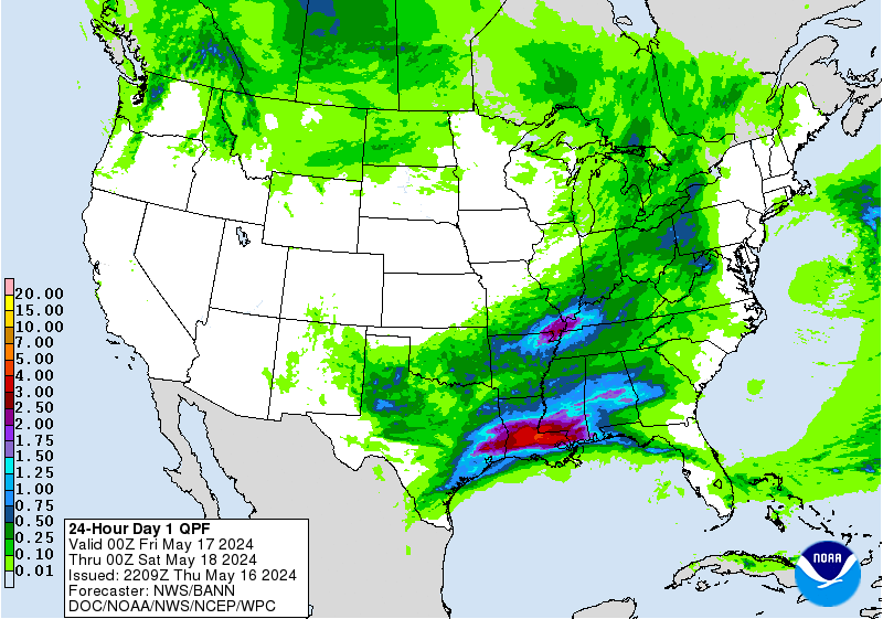
Picture worth 1,000 words. Past 24 hour rains:
![]()
It's been very dry in parts of the Cornbelt, especially IN/IL the past 60 days. Upcoming rains will continue to hit the driest spots!
You can go to this link to see rain totals from recent time periods:
https://water.weather.gov/precip/
Go to precipitation, then scroll down to pick a time frame. Hit states to get the borders to see locations better. Under products, you can hit %normal.
You can see how big the dry pockets.........are shrinking are right now. Since the crop ratings are near the best ever 78% GD/EX corn and 75% beans, clearly this dryness has not effected the condition of the overall crop yet.
Crop ratings will likely drop a bit next Monday........from the dry places that don't get rains(which may come next week) but will maintain after that.
Rains the next 7 days, graph of totals. Heaviest rains now in the Eastern Cornbelt.
Day 1:
http://www.wpc.ncep.noaa.gov/qpf/fill_94qwbg.gif?1526306199054
Day 2:
http://www.wpc.ncep.noaa.gov/qpf/fill_98qwbg.gif?1528293750112
Day 3:
http://www.wpc.ncep.noaa.gov/qpf/fill_99qwbg.gif?1528293842764
Days 4-5:
http://www.wpc.ncep.noaa.gov/qpf/95ep48iwbg_fill.gif?1526306162
Days 6-7:
http://www.wpc.ncep.noaa.gov/qpf/97ep48iwbg_fill.gif?1526306162
Total accumulation
http://www.wpc.ncep.noaa.gov/qpf/p168i.gif?1526397762

mcfarms NWS forecast:
Today
Showers likely, with thunderstorms also possible after 11am. Mostly cloudy, with a high near 88. South southwest wind 7 to 9 mph. Chance of precipitation is 60%. New rainfall amounts between a tenth and quarter of an inch, except higher amounts possible in thunderstorms.
Tonight
A 50 percent chance of showers and thunderstorms. Mostly cloudy, with a low around 67. South southwest wind around 8 mph. New rainfall amounts between a quarter and half of an inch possible.
Monday
A 50 percent chance of showers and thunderstorms. Mostly cloudy, with a high near 86. West southwest wind 7 to 10 mph. New rainfall amounts between a tenth and quarter of an inch, except higher amounts possible in thunderstorms.
Monday Night
A 30 percent chance of showers and thunderstorms. Mostly cloudy, with a low around 67. Southwest wind 6 to 8 mph.
Tuesday
A 40 percent chance of showers and thunderstorms. Partly sunny, with a high near 87. Southwest wind around 7 mph.
Tuesday Night
A 30 percent chance of showers and thunderstorms, mainly before 2am. Mostly cloudy, with a low around 66.
Wednesday
Mostly sunny, with a high near 86.
Wednesday Night
Partly cloudy, with a low around 65.
Thursday
A 30 percent chance of showers and thunderstorms after 2pm. Partly sunny, with a high near 85.
Thursday Night
A 30 percent chance of showers and thunderstorms. Mostly cloudy, with a low around 66.
Friday
A 30 percent chance of showers and thunderstorms. Partly sunny, with a high near 85.
Friday Night
A 20 percent chance of showers and thunderstorms. Partly cloudy, with a low around 64.
Saturday
A 10 percent chance of showers and thunderstorms. Mostly sunny, with a high near 84.
Reason for storms to dry up as they headed across Indiana recently:
Regarding the storms dying as they approached the big city(Indianapolis) Am thinking that more likely they just traveled over a long stretch of bone dry ground and the moisture inflow from the south into the storms was not enough to over come this as they dried up.
The old expression, "drought begets drought" applies here.
Dew points ahead of these storms were only in the 60's. By June standards, that's pretty low. Typically, with the weather pattern similar to this we would have dew points well into the 70's. Very often, at this time of year if the ground is moist and you are getting some evapotranspiration from the rapidly growing corn plants it will contribute around 5 to as much as 10 degrees worth of dew point to the lower levels. That is mostly absent right now.
That can mean the difference between sustaining storms that were out there today and them dying as they hit the much drier air in Indiana(dew points in the 60's on bone dry soils)
In addition to that explanation above I posted this below............the dew point map has been updated to Sunday.
" Typically in June, under these conditions, we might see 70+ dew points from the GOM well into the Midwest, with a few embedded 75+ dewpoints providing moisture for these storms.
They are mostly in the 60's right now. Only a couple of isolated pockets at or just above 70.
Even along the Gulf Coast, many of the dew points are in the upper 60's. Looking ahead, even with a very promising weather pattern it just doesn't look like the typical juicy Gulf moisture ever gets injected in.
For sure there will be alot of rains in alot of places, including your farms hopefully but not with the confidence as if we had dew points well into the 70's to work with"

7pm update. The rains in S.Indiana also dried up for the reasoning above and we ended up with .23 in my backyard north of Evansville, with the NWS getting just .18 out of storms that looked like they would dump MUCH more. There were scattered higher amounts.
The Indianapolis total was .05 and I'm guessing you got almost nothing mcfarm.
Severe Storm Potential the next few days:
Current Day 1 Outlook | Forecaster: Kerr Issued: 10/0107Z Valid: 10/0100Z - 10/1200Z Forecast Risk of Severe Storms: Enhanced Risk |
Current Day 2 Outlook | Forecaster: Bunting Issued: 09/1728Z Valid: 10/1200Z - 11/1200Z Forecast Risk of Severe Storms: Slight Risk |
Current Day 3 Outlook | Forecaster: Dial Issued: 09/0726Z Valid: 11/1200Z - 12/1200Z Forecast Risk of Severe Storms: Slight Risk |
Current Day 4-8 Outlook | F |
Excessive rain potential...mainly just today and tomorrow.
Current Day 1 Forecast Valid 15Z 06/10/18 - 12Z 06/11/18 |
Day 1 Threat Area in Text Format
| Day 2 and Day 3 Forecasts |
Current Day 2 Forecast Valid 12Z 06/11/18 - 12Z 06/12/18 |
Day 2 Threat Area in Text Format
Current Day 3 Forecast |
Is it safe to play this now mcfarm?
https://www.youtube.com/watch?v=B0asbGJbLKc
Tell us whats happening at your farms.
first batch this morning was a disappointment again this system right now has the potential to drop more rain than the last months total....we will see
Thanks PLL. Not much more than dampening the top soil!
mcfarm,
I am watching it continue to dry up just before hitting you because of the reasoning earlier but these storms tracking southeast into the dry air should be saturating it farther downstream and allowing some progression.
Am hopeful this next batch will make it farther southeast.
One problem mcfarm is the MCC's like this often die down in the late morning. Also, the radar is very often over generous estimating rains in a situation like this. Radar is estimating the rains from what it sees in the clouds. When you have a situation with rains drying up as they track into drier air/dry ground, the dynamic in the clouds where the rain is being reflected back from might be providing a rosier picture than whats happening on the ground............after most of that rain has dried up.
But at least you will be getting some rain here with high confidence...............and if this dynamic stalls out and gets enough moisture inflow and training/back building, you could end up with a ton of rain.
OK, the NWS sees this too........has mcfarm over the targeted area for training.
http://www.wpc.ncep.noaa.gov/metwatch/metwatch_mpd_multi.php?md=0281&yr=2018

Their statement:
AREAS AFFECTED...CENTRAL/EASTERN IL...WESTERN/CENTRAL IN
CONCERNING...HEAVY RAINFALL...FLASH FLOODING POSSIBLE
VALID 101415Z - 101915Z
SUMMARY...A TRAINING AXIS OF HEAVY SHOWERS AND THUNDERSTORMS MAY RESULT IN SOME FLASH FLOODING OVER THE NEXT FEW HOURS.
DISCUSSION...VERY COLD CONVECTIVE TOPS CONTINUE ACROSS A LARGE AREA OF CENTRAL TO EASTERN IL...AND WILL BE SPREADING EAST ACROSS WESTERN AND CENTRAL IN OVER THE NEXT FEW HOURS IN ASSOCIATION WITH AN AXIS OF HEAVY SHOWERS AND THUNDERSTORMS.
THE ACTIVITY IS FOCUSED AROUND THE SOUTHERN FLANK OF A STRONG MCV AND ACCOMPANYING PV ANOMALY ALONG THE WI/IL BORDER. A WESTERLY 850 MB JET OF 30 TO 40 KTS IS TRANSPORTING PLENTY OF MOISTURE AND INSTABILITY EAST ACROSS THE MIDWEST...WITH MUCAPE VALUES OF 500 TO 1000 J/KG AND PWATS OF 1.5 TO 1.75 INCHES.
THE NOSE OF BETTER INSTABILITY WITH THE AIDE OF THE LOW LEVEL JET WILL EDGE EAST ACROSS WESTERN AND CENTRAL IN OVER THE NEXT FEW HOURS AND GIVEN THE UPSTREAM CONVECTION ALIGNING ITSELF GENERALLY WNW/ESE AND VERY CLOSE TO THE 850/300 MB LAYER FLOW...THERE WILL BE A FAVORABLE SET-UP FOR TRAINING CONVECTION.
RAINFALL RATES OF AS MUCH AS 2 INCHES/HR ARE EXPECTED...AND WITH THE TRAINING CONVECTIVE ELEMENTS...ADDITIONAL STORM TOTALS OF 3 TO 4 INCHES WILL BE POSSIBLE. THIS IS CONSISTENT WITH THE LATEST HRRR/HRRRX MODEL OUTPUT WHICH IS IN STRONG AGREEMENT ON THE AXIS. THE ANTECEDENT CONDITIONS ACROSS THE REGION ARE RATHER WET OVERALL...AND SO FLASH FLOODING WILL BE POSSIBLE OVER THE NEXT FEW HOURS.
Update at Noon: As of 10am Central, Indianapolis had .34, then .78 an hour later which is probably more than you had at the time.
Thinking you could come out of this with an inch+ of rain mcfarm if it doesn't suddenly fade here.
PLL,
What county and what part are you located in southcental IL?
Thinking that you are just northwest of Effingham?
Things could always be much worse.
You could have been born on the other side of the planet and be getting more than enough rain..............while doing this:

Moultrie County 30 miles north of Effingham. Right now dry county surrounded by rain on radar
Thanks PLL,
So you live by Sullivan ILL.
Radars are lighting up bigtime! mcfarm about to get more rain.
How much did you get cutworm?
Will watch these storm in IL now too. PLL, looks like you got Harley'd on that batch that had explosive growth right after passing east of you.
Am liking this radar link for eastcentral IL.
Looks like the storms are finally hitting you with some rain now PLL

Yes we did .1
Ouch!!
That really hurts, especially with 20 times that amount 1 county northeast of you.
You've have been barely in the capped, warm air aloft zone, with these storm clusters/ridge riders moving along the periphery, just north to northeast of you, then east of you as they tracked east to southeast.
The good news is that these storms earlier have laid down a boundary that should be the focus for new storms that could be slightly farther southwest....and could hit you.
Not a sure thing though but am hopeful.
Rains the next 24 hours
http://www.wpc.ncep.noaa.gov/qpf/fill_94qwbg.gif?1528665917896
PLL,
Maybe you got a bit of rain from the last batch but the new ones erupting to your west are coming in farther south as expected.
At least they have a much better chance of hitting you, even though they are not as solid as the stuff from earlier.
Indy is approaching 2 inches of rain for the day. mcfarm, do you know how much you got?
cutworm,
What county are you in in southeast IN? Looks like most of the rains earlier dried up headed into se IN and now the latest batch wants to curve towards the south.....though there is still enough eastward movement to the huge blob that you may get a good one.
We got a great day of rain here in NE Ohio. I couldn't tell you how much, but it had to be well over an inch.
n and c Franklin co.
we had 1/4 with the first round and now have a total of 4/10
Thanks Cutworm,
Just enough to get the very top soils wet.
So you are something like 40 mile E/NE from Greensburg?
PLL,
You must be frustrated now that the big storms are south of you after huge rains fell north and east of you earlier....though it looks like the northern edge has brought some light stuff to your farms.
mcfarm finally got him a great rain. Am looking forward to hearing his total,.
Got another .65 here in Evansville, to tally an inch total for the weekend.
The counties just north and northeast of here got 6 inches in 90 minutes earlier this evening.
6 in in 90 min would be a 500 year flood and i don't wish that on anyone.
PLL,
Looks like the rains shifted north and gave you some much better amounts .
2.5-5.0
Wonderful PLL!!!!
