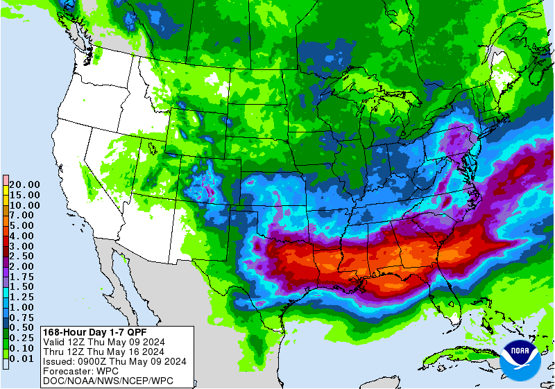
Though nothing like the heaviness of Michael’s rains, I’ve already posted about the recent unwanted widespread soaking rains from two separate batches less than one day apart in NW TX (and I should add SW OK) CT areas. Now, the remnants of Sergio are headed for those same areas tonight and early tomorrow. These look to put down mostly 1-1.5”.
Then, if that weren’t enough, very cold will follow along with additional lighter precip that will include wintry in some areas. Furthermore, there is a freeze threat due to record cold for especially western areas of NW TX for Mon and Tue mornings that could stop the growth of not yet opened CT though fortunately from a freeze threat standpoint most is fully mature/open.
In addition to NW TX, the Delta, which has actually had good harvest wx of late, is looking to get significant rains (1-3”) Sun-Tue per models from a combo of Sergio remnants and followup TX system(s).
With what has already happened in the SE US from Michael and earlier from Florence, these NW TX and Delta harvest issues are the last thing you’d want to see if you want a very large US CT crop to still verify.

....polyester that accentuates the HIGH COTTON.... !
Thanks Larry,
I forgot to mention the cold for the TX panhandle earlier. These are day 3 lows, which is Monday right now. Tomorrow, day 3 will be Tuesday and those lows will be just as cold on this map below.

With regards to the real heavy rains, they will be east of the highest production areas for TX cotton but still have a negative impact and also in E.Arkansas down to NW. Mississippi.
Forecast Hour: 171
Image URL: http://mag.ncep.noaa.gov/data/gfs/18/namer/precip_ptot/gfs_namer_171_precip_ptot.gif

The NW TX/SW OK area continues to have really lousy harvest wx with significant rains (vs climo) and cold temps. Today, Lubbock has had ~1/2” so far with another ~1/4” expected through tonight. That will bring Oct MTD to ~3.75”, which is 3 times their normal for 10/1-18. They have had on again off again rain for nearly 2 weeks along with chilly temperatures. Model consensus gives them still another ~1”early next week. The area from Childress to SW OK has had even more, 5-8” so far in Oct. with more falling today and more expected early next week.
None of this can possibly be good for harvest. Therefore, I expect a drop in condition in the next crop progress report as well as a slowdown in harvest in TX and possibly also in OK. With this in mind as well as the early freeze that likely covered nearly half of the 20% immature TX crop, the odds are increasing for the USDA to reduce these 2 states’ crop sizes in the next monthly report.
Good thoughts Larry!
The heavy rain shield will shift north again early next week and be effecting some key cotton growing areas again. Next Tue/Wed look especially wet.
The Nov forecast came out wet in the south but its doubtful the cotton market would trade on that.
Thanks, Mike.
Last 30 days rainfall (9/19-10/18) vs normal close not much above 2": these 3 cities got heaviest for this period since 2004
Lubbock: 5.92"
Plainview: 5.59"
Seminole: 6.35"
Before that it was 1985 and then 1974 for Lubbock and Plainview. I didn't check Seminole yet. So, these are about a once in 13 year heavy rain for this 30 day period for at least Lubbock and Plainview.
Childress: 8.51" (which is also near the very wet SW OK belt and vs normal of ~3"), heaviest for 9/19-10/18 since 1942. Before that, 1926. So, this is about a once in 40 or so heavy rain for this 30 day period.
So, this has been a pretty big deal as regards harvest hampering for NW TX/SW OK, especially with the chilly temperatures,and still more moderate rains are expected early next week. The key is that there has been a lot of cloudcover and rains have been occurring every few days along with cold temperatures of late. Not good conditions for open bolls sitting out these as well finally getting to harvest them.
More great stuff Larry.
It's incredible that the cotton price has not responded much stronger than this. Obviously demand is horrible and prices are actually close to the highest prices in the last 6 years........in a global market.
If we lose a massive amount of the US crop but can't sell it at higher prices, then its hard to justify higher prices.
Looks like one main rain event for the panhandle, late Tue into Wednesday next week. However, the pattern for the entire south looks pretty wet for the next 2 weeks. It actually includes all of the cotton growing region east of the panhandle. There will be a lot of unharvested cotton that deteriorates if we have numerous rain events.
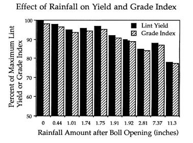
I will do some research on this because its obviously going to have an increasing impact on the quality of the cotton crop this year. There are a host of issues that are caused by weather that's too wet.
Am not sure if this actually is counterproductive to price in a way. If the quality drops, then the price it can be sold at might also go down.
Image URL: http://mag.ncep.noaa.gov/data/gfs/18/namer/precip_ptot/gfs_namer_384_precip_ptot.gif

https://hundredpercentcotton.com/farm/cotton-101-video-impacts-of-rain-on-cotton-during-harvest12/
Here is a wonderful comprehensive discussion about all the bad things that happen to cotton which is subjected to conditions that are too wet during harvest season:
COTTON PHYSIOLOGY TODAY
Boll Weathering
https://www.cotton.org/tech/physiology/cpt/fiberquality/upload/CPT-Nov92-REPOP.pdf
Larry,
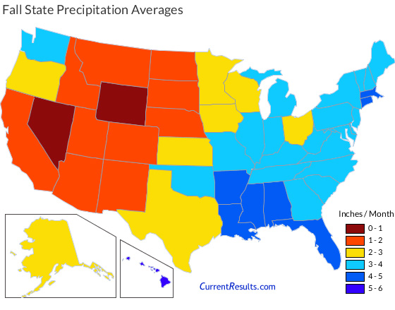
I was just thinking about the once every decade+ type rains you showed for the panhandle areas. This is alot of rain for that location but if it had fallen in the Gulf States, let's say Mississippi, that would be just a bit higher than average rain(which is over double the average for the panhandle of TX.
Update: In case this map is not loading, you can get it a the link below:
https://www.currentresults.com/Weather/US/average-state-precipitation-in-fall.php
The TX crop will deteriorate on the crop condition report on Monday from the freeze and rain.
Question will become, what will happen to the unharvested crop east of those areas that gets too wet and stays wet into November?
Crop progress:
You can note the % of the crop harvested as of the last report in each state. Once it gets wet in some of these places, it may not dry out enough to harvest the cotton for a long time.
http://usda.mannlib.cornell.edu/usda/current/CropProg/CropProg-10-15-2018.txt
Mike said: “Am not sure if this actually is counterproductive to price in a way. If the quality drops, then the price it can be sold at might also go down.”
————————————————
Mike,
No, it is actually the opposite because there are minimum standards required to satisfy what a contract represents. If good quality CT becomes damaged or colored, it reduces the supply of good quality CT. The reduced supply of good then puts upward price pressure on the grade of good grade CT, which is what trades on the exchange.
Mike said: “Larry, I was just thinking about the once every decade+ type rains you showed for the panhandle areas. This is alot of rain for that location but if it had fallen in the Gulf States, let's say Mississippi, that would be just a bit higher than average rain(which is over double the average for the panhandle of TX.”
—————————————————
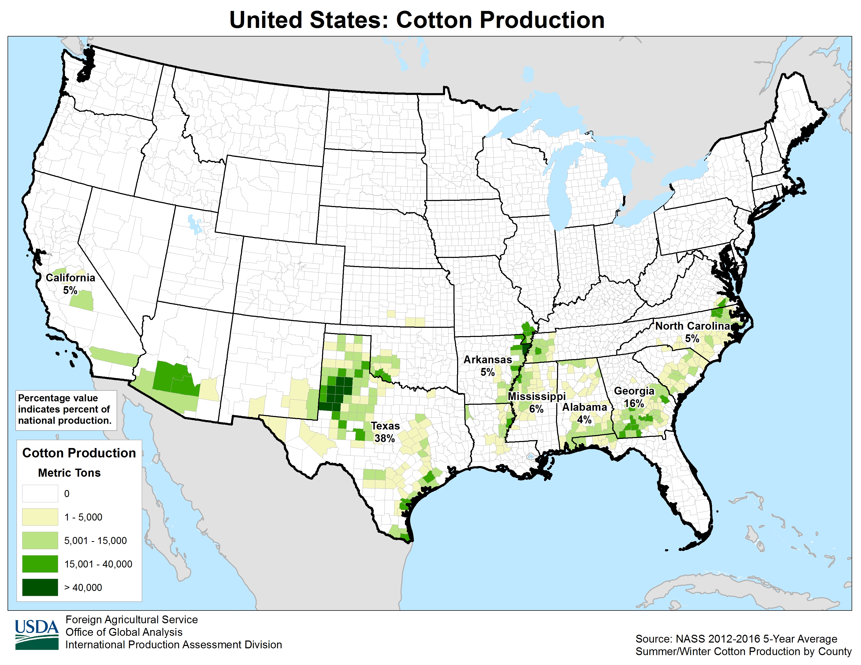
Indeed, normal Oct rainfall in the TX Panhandle is only about half that of the Delta CT region. Lubbock’s annual normal is only like 19”. So, they’re semi-arid. So, them getting, say, 5” in any month is a big deal....the equivalent of the Delta getting something like 10” in any one month.
The latest model consensus is still giving the TX panhandle still another significant rain (~0.5-1.5”) late Tue through Wed AM with this possibly being enhanced by upper level moisture from EPAC storm Willa. This would bring Lubbock up to near 5” for Oct vs just under 2” for its entire month normal.
After this rain, there will likely be a long enough break to finally allow significant drying and harvesting after a very wet prior 30+ days as models don’t show much after early next week and November is normally very dry (though no warmer than normal stretch is yet seen). The question would then be how much damage in NW TX/SW OK would have already occurred to the mature CT due to the prior persistent wetness/chill along with the growth stoppage or slowdown of ~600K of immature bales hit by the mid Oct freeze (~400K bales hit by long durations of freeze with the lowest of 27-30). I’m guessing no more than 100-200K lost from the freeze and accompanying strong winds.
However, I counted 5 times over the last 45 years (1 in 9 years) that the USDA has reduced the TX/OK crop 3% or more in the Nov report vs the Oct report due to a wet Oct there. IF they were to reduce it by just 3%, that would be ~225K bales. Of course, they could offset some of the TX/OK/GA/AL/FL/NC losses with gains in the Delta and/or SW US but they would pale in comparison.
The largest aggregate US % drop on record from the Oct to Nov reports since 1964 is 6% (set in 1974), followed by 5% (1969), and 4% (2009, 1993, 1976, 1966). So, a 4%+ drop in the Nov report has occurred ~1 every 10 years. I will be very surprised if there isn’t another 4%+ drop in the Nov of 2018 report. Even a record tieing 6% drop wouldn’t surprise me IF GA/AL/TX/OK/FL/NC are given the losses I think they have had and IF the Delta/SW is not given any significant gains (I’m not predicting those 2 areas). I wouldn’t even bet the ranch against a new record high US Nov report % drop though I’m not predicting that right now.
—————————————————-
Edit: Since I wrote the above, I discovered that both the main KS (south) and AZ (south central) areas have also had way above normal rains the last 30 days accompanied by below normal temperatures. Those 2 states, combined, had last been projected to produce over 800K bales. So, now we have these states with potential (likely imo) poor Oct harvest wx related losses (Mike's past 30 day rainfall maps show this well, too, with their solid blue colors):
GA/AL/FL/NC/TX/OK/KS/AZ
Thanks Larry,
The next crop production report from the USDA is November 8th. The estimates ahead of that will have enormous cuts in production.
With regards to upcoming weather, we have the weather system that moves from west to east across the south, starting Tuesday Night in the Panhandle and ending in Georgia around Friday but maybe into NC/SC into next weekend.