Previous threads:
The big thaw! 2-2-26
17 responses |
Started by metmike - Feb. 2, 2026, 1:48 p.m.
https://www.marketforum.com/forum/topic/117703/
++++++++++++++
1-23-26+ Tracking the historic Winter Storm
22 responses |
Started by metmike - Jan. 24, 2026, 12:17 a.m.
https://www.marketforum.com/forum/topic/117428/
+++++++++++++++++
Historic snow/ice, late week of 1/18/26
26 responses |
Started by metmike - Jan. 18, 2026, 4:49 p.m.
https://www.marketforum.com/forum/topic/117294/
++++++++++++++
Frigid Blast
Started by metmike - Jan. 17, 2026, 10:44 p.m.
https://www.marketforum.com/forum/topic/117282/
++++++++++++++
Get all the comprehensive weather here:
The strong Pacific origin jet stream will play a key role in our weather this week. This is the look at the jet stream in the Pacific.
The upper level low is just off the Pacific Northwest coast.
Currently, we see a phasing of the Polar(northern) jet stream and a farther south subtropical jet.
Ahead of that, the Midwest will see southwest steering currents and strong south winds at the surface.
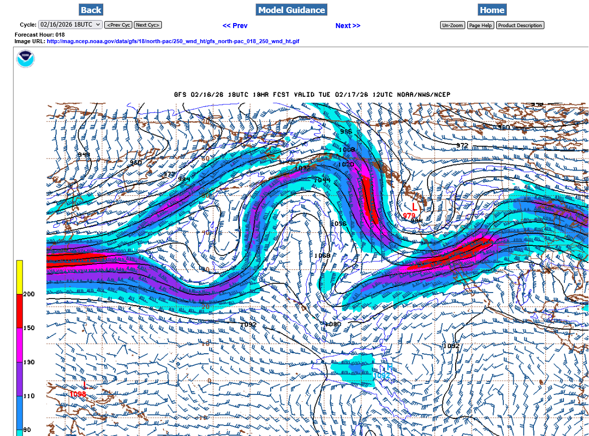
Shifting the map much farther east and time frame to late Thursday, we see the MAINg jet stream aimed in this direction. The red shade is 150 knots which is almost 175 mph.
Plenty strong enough to generate the lift and spin/rotation for severe storms and some tornadoes that will be possible late Thursday.
https://mag.ncep.noaa.gov/Image.php
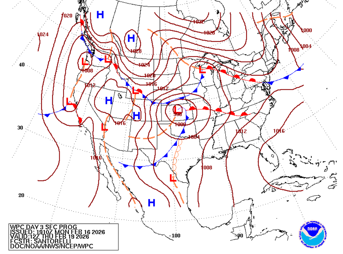
This is the surface map below early on Thursday. A surface low pressure system is developing/deepening in KS with warm, humid unstable air gushing north ahead of it and cold Arctic air dropping south from Canada with a robust High north of Montana.
In addition, we can see a Pacific cold front in Texas, with a dry line trough behind it.
https://www.wpc.ncep.noaa.gov/medr/nav_conus_pmsl.php?fday=3&fcolor=wbg
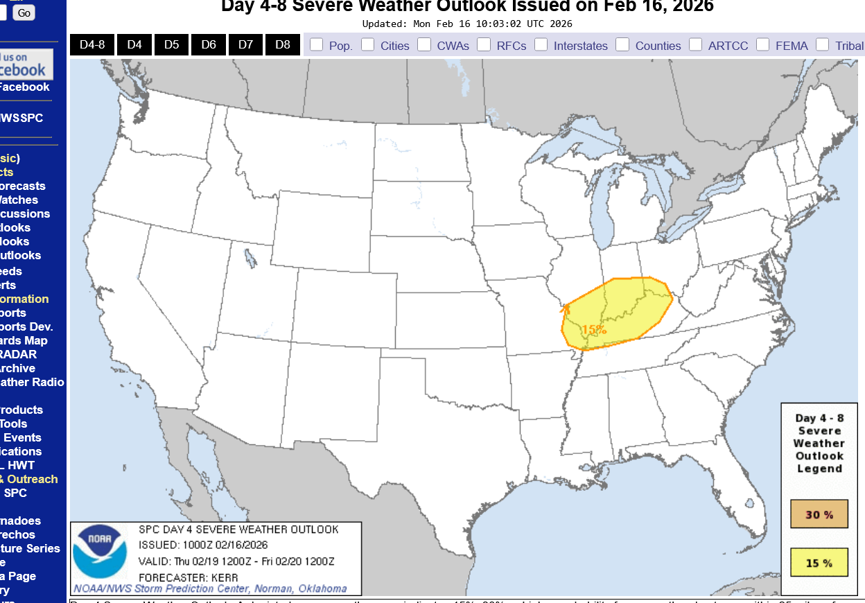
The Storm Prediction Center issues general severe weather risk areas up to 8 days ahead of the events. We are currently in an area that has some risk. As we get closer, the will refine the risk. It should be AT LEAST a slight, level 2 risk, with potential for an enhanced level 3 risk. It's not completely impossible to have it elevated to moderate, level 4 risk.
https://www.spc.noaa.gov/products/exper/day4-8/#
See the explanations below:
https://www.weather.gov/media/ewx/iwt/SPC_WPC_Differences.pdf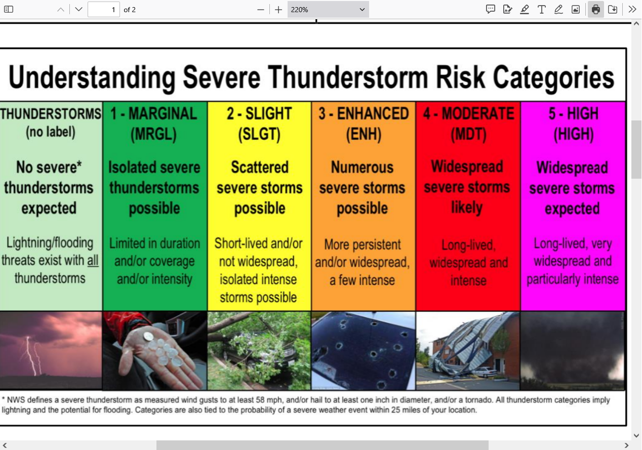
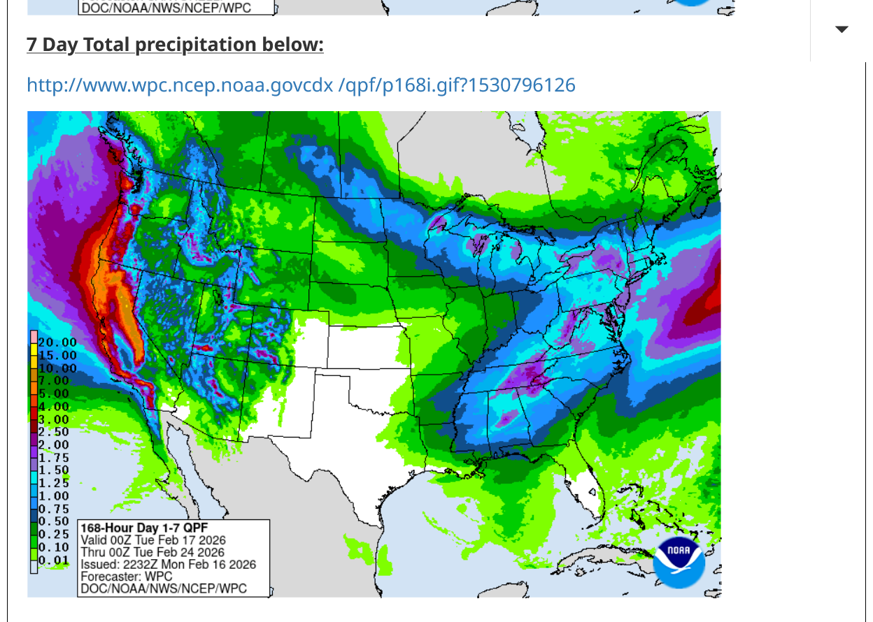
The good news is that many areas will see welcome rains and in the mountains, welcome snows that will melt late in the year and provide wonderful water to communities downstream of the melt water.
https://www.marketforum.com/forum/topic/83844/#83848
https://www.wpc.ncep.noaa.gov/qpf/p168i.gif?1530796126
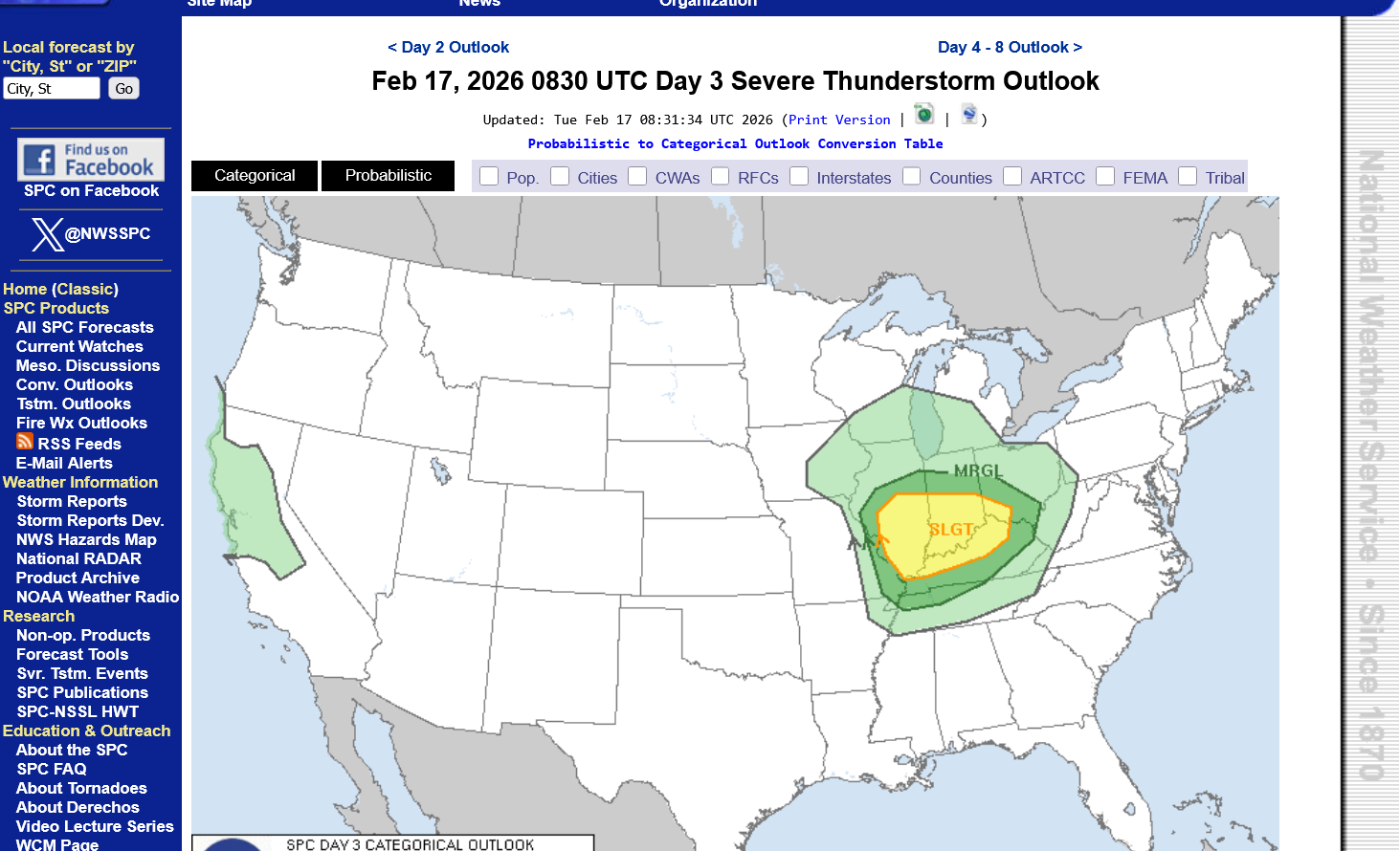
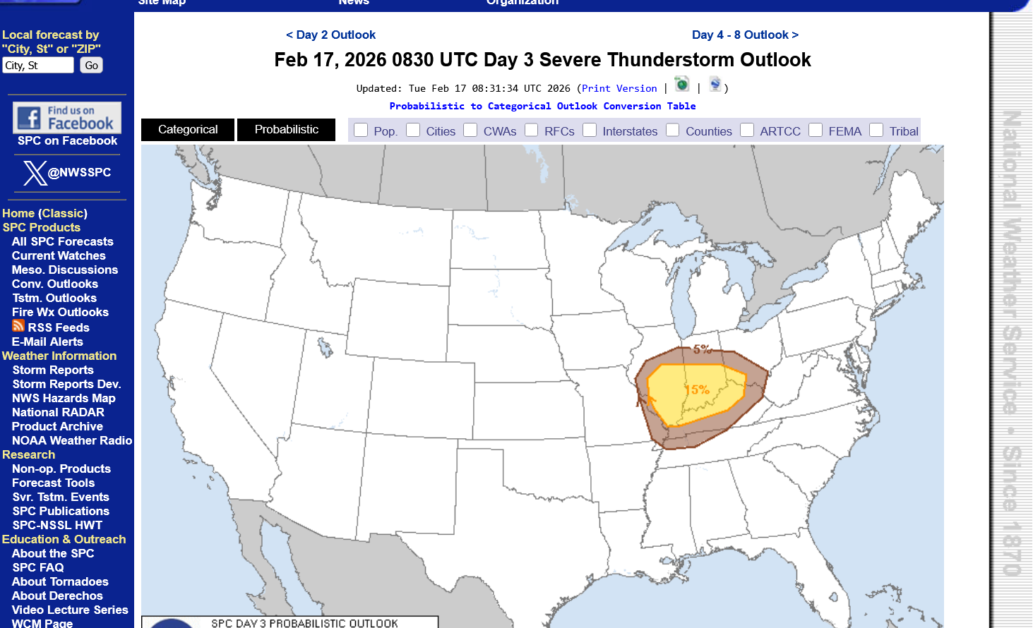
Tuesday's update from the Storm Prediction Center:
https://www.spc.noaa.gov/products/outlook/day3otlk.html
This is not likely to be a major outbreak of violent tornadoes. However, there is likely to be SOME severe weather that includes a few tornadoes and potentially a strong tornado. With that being the case, the smart thing to do is to monitor it, especially as the cold front triggering storms approaches on Thursday.
When a watch is issued, if it's a TORNADO watch. Stay very tuned into the weather as the storms get close. If there aren't many reports of severe weather as it approaches or none of them are tornadoes, the need to go to a safe place is low. Severe storms will not hurt you inside a permanent building with a foundation. Even weak tornadoes won't hurt you but stay away from windows.
However, STRONG tornadoes, which tend to be long lived and easily tracked and well warned for are the ones that justify going to the safest place in your home(lowest level/basement and center of the house).
The Storm Prediction Center will usually have this verbiage in their statements when the dynamics are favorable for strong to violent tornadoes: "This is a particularly dangerous situation"
If you see that verbiage, it's time to forget "The boy who cried wolf" mentality of the past XX times of storms coming thru and nothing happened to you, which will probably be this time too.
That verbiage justifies staying up to see if a strong tornado is headed for your county/neighborhood overnight. If you have a weather radio is will wake you up for that.
Not having that more alarming verbiage doesn't mean a strong tornado can't happen but the chances are greatly reduced. WEAK tornadoes, yes but 150+ mph tornadoes that kill the most people, not so much.
Most tornadoes are WEAK tornadoes fortunately. This is event is still 2+ days away but the dynamics at this point favor weak tornadoes, although some guidance is more elevated.
I would not be surprised if they increase the risk to a level 3 of 5 "enhanced" with tomorrows update as the event gets closer. I would be extremely surprised if this system approaching ever results in a level 5 of 5 "high" risk and probably not even 4 of 5 "moderate" risk. Those are the levels which result in that "this is a particularly dangerous situation" verbiage.
The type of tornado possible late Thursday would most likely fall into the EFO and EF1 category below. An EF2 is also possible. Higher categories can't be ruled out completely but the dynamics are UNfavorable for the strongest tornadoes that kill the most people.
Be prepared late Thursday but know that this is not likely to be a particularly dangerous situation.
Enhanced Fuita scale
https://en.wikipedia.org/wiki/Enhanced_Fujita_scale
| EFU | Unknown | No surveyable damage |
|---|---|---|
| EF0 | 65–85 mph | Light damage |
| EF1 | 86–110 mph | Moderate damage |
| EF2 | 111–135 mph | Considerable damage |
| EF3 | 136–165 mph | Severe damage |
| EF4 | 166–200 mph | Devastating damage |
| EF5 | >200 mph | Incredible damage |
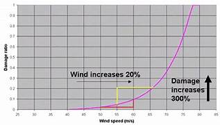
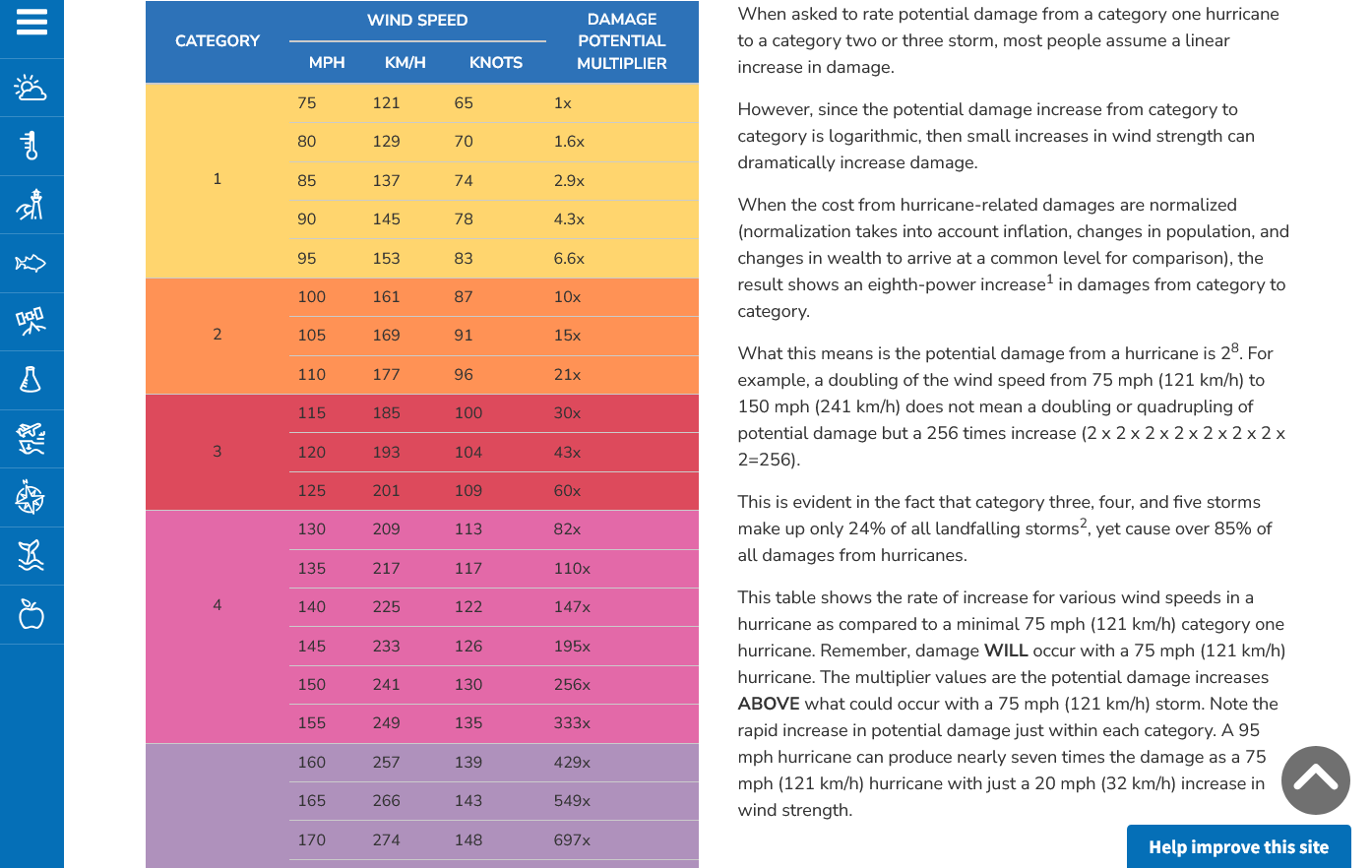
Here's the deal on wind and damage.
As wind increases the damage massively increases on an exponential scale. This applies to ALL wind.
Severe storms and hurricanes and especially tornadoes that have the strongest winds of all, which means the tornadoes with winds over 150 mph have incredible damage.
+++++++++++
+++++++++++++++++++++
A 150 mph wind does 256X more damage than a 75 mph wind. Let's repeat that. A 150 mph wind does 256x more damage than a 75 mph wind!
Hurricane Damage Potential
https://www.noaa.gov/jetstream/tc-potential
++++++++++++
Less than 1% of tornadoes are F4 or F5 but they kill 67% of the people!
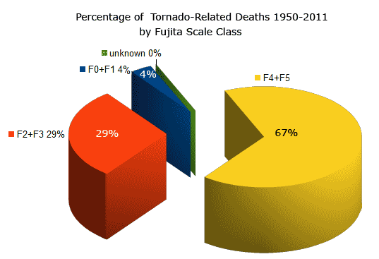
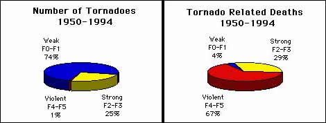
Note that the majority of tornadoes, F0 and F1= 74%(on the old scale) only killed 4% of people and they were probably outside or in a mobile home.
The F4 and F5's were just 1% but caused 67% of deaths.
+++++++++++++++++++
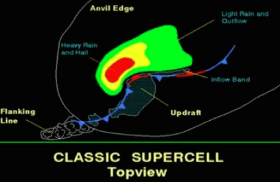
https://www.weather.gov/ama/supercell
++++++++++++
Excellent presentation at this link below that describes the different types of tornadoes and the damage they cause. Keep in mind that the EF4 and EF5 tornadoes are extremely rare. Less than 1% of tornadoes are this strong. Today is one of those rare days.
The EF4 and EF5 tornadoes will usually have the HIGH, level 5 risk earlier that day.
Mike Simon Tornado Damage Intensity; Enhanced Fujita Scale
Very deep low right now in the Northern Plains.
https://www.spc.noaa.gov/exper/mesoanalysis/new/viewsector.php?sector=19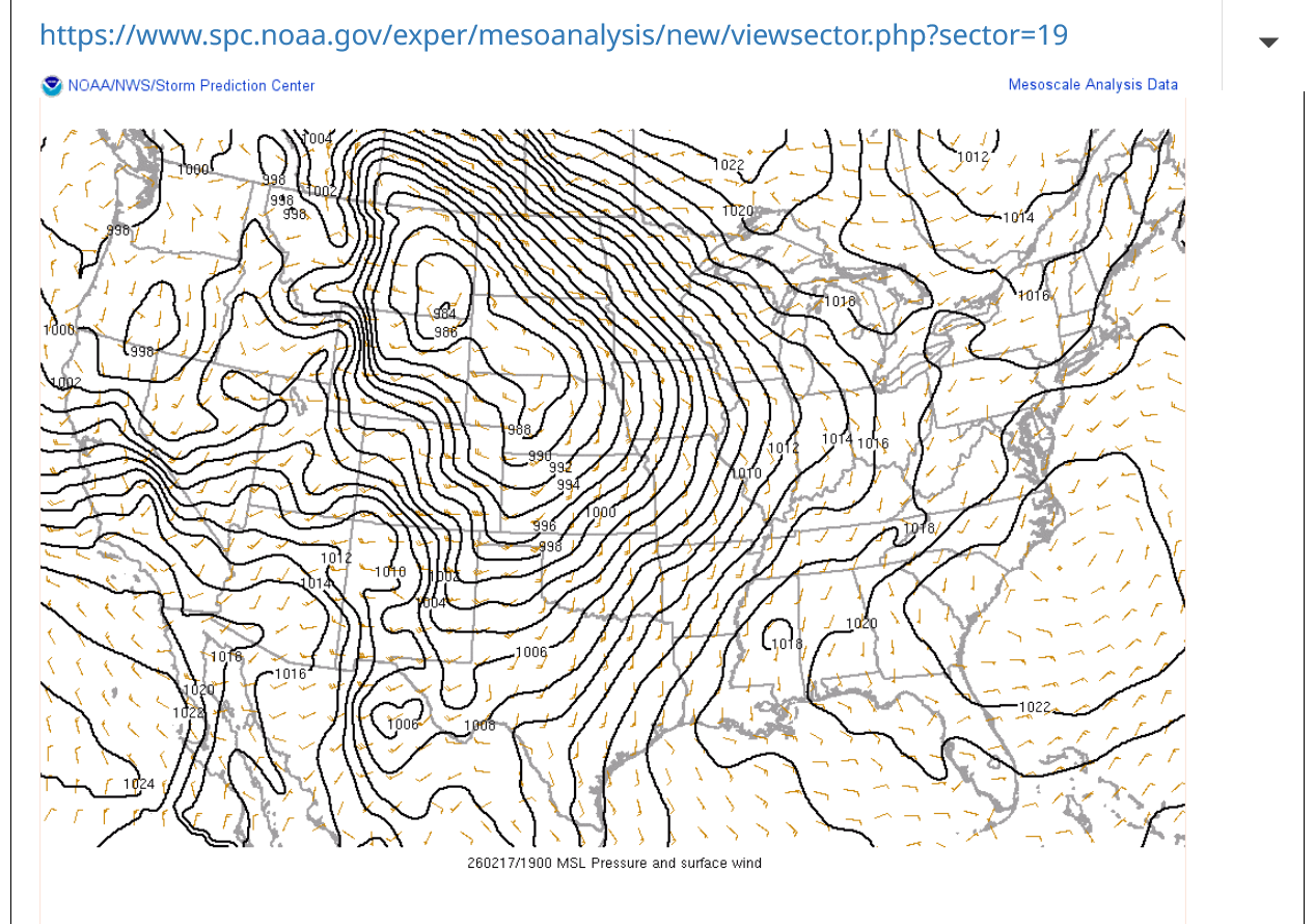
No severe weather because the deep moisture has not returned. The 70's are bone dry, desert type air.
https://www.marketforum.com/forum/topic/83844/#83845