
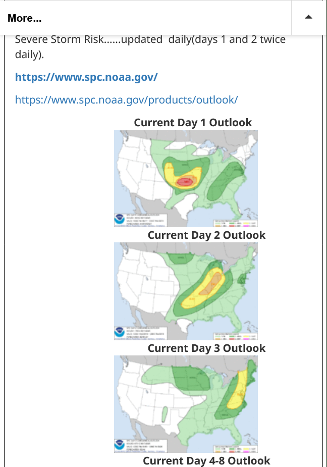
Go to this link for the latest updates:
Severe Storm Risk......updated daily(days 1 and 2 twice daily).
https://www.spc.noaa.gov/
https://www.spc.noaa.gov/products/outlook/
+++++++++++++++++
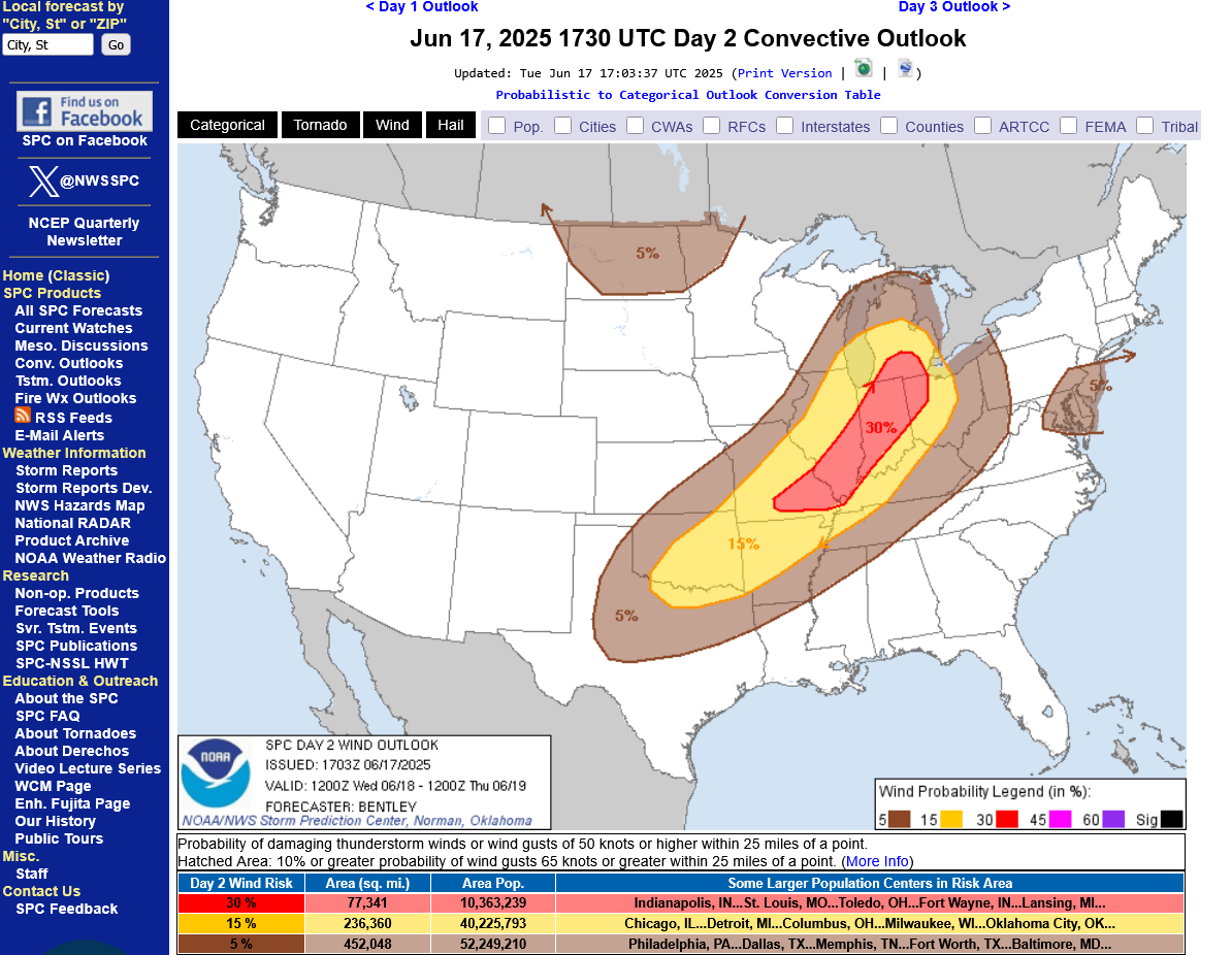
As of 2pm CDT on Tuesday:
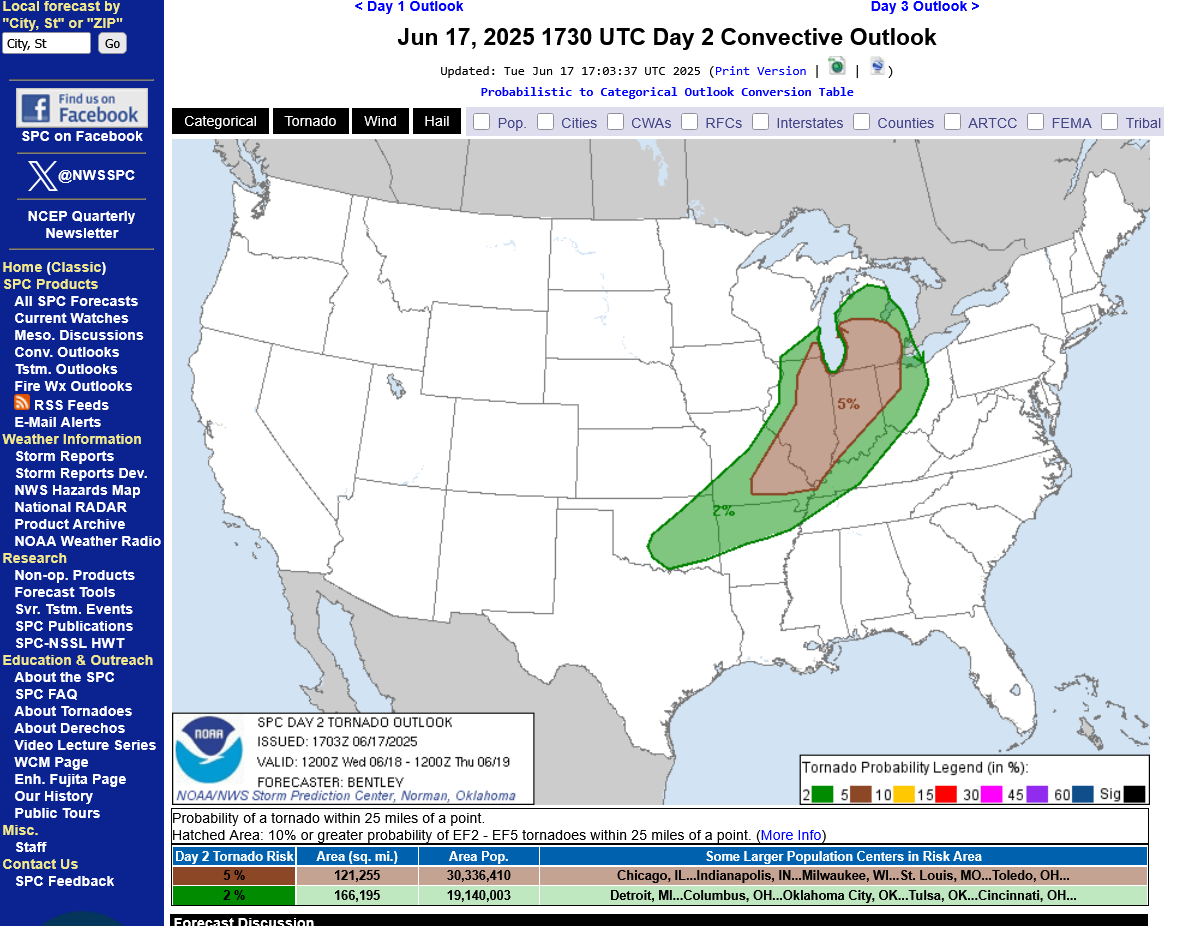
The main risk is for severe thunderstorm winds and NOT tornadoes in Indiana on Wednesday:
1. Damaging wind probability of winds greater than 58 mph within 25 miles of your house/location. 30%+ in red.
2. Tornado probability within 25 miles of your house. 5% in brown. 2% in green.
++++++++++
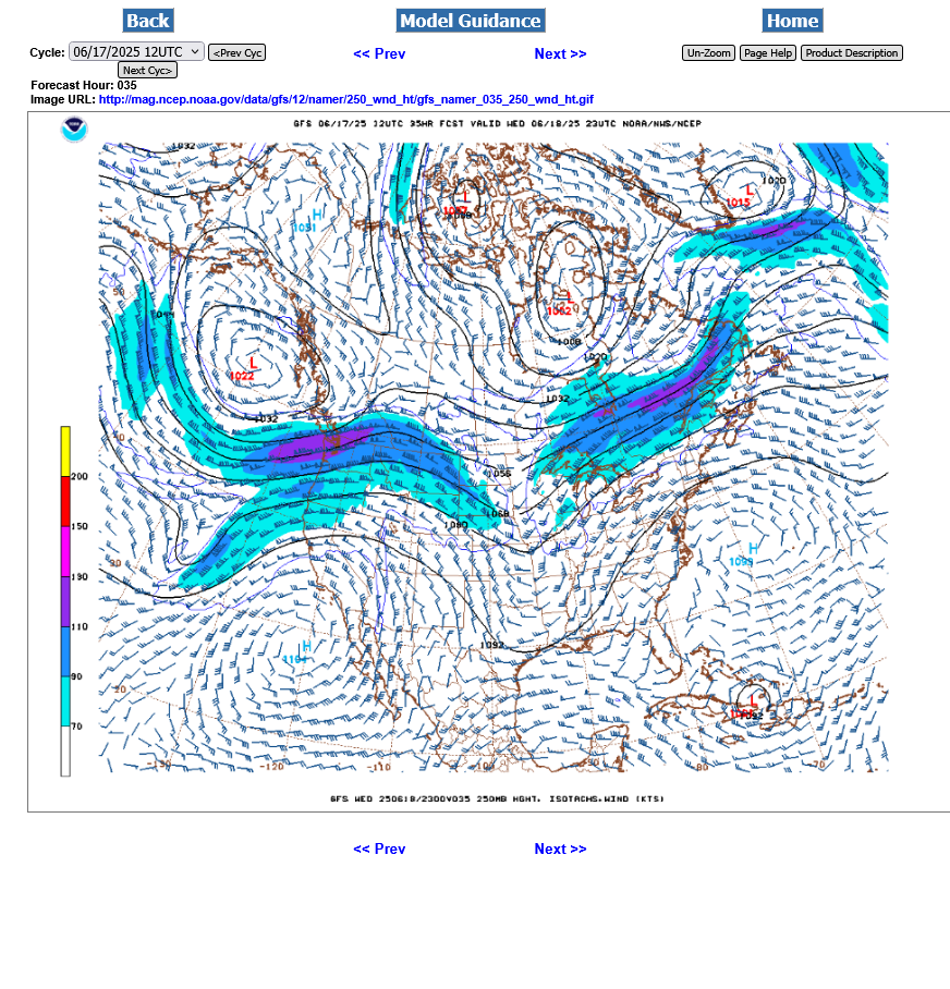
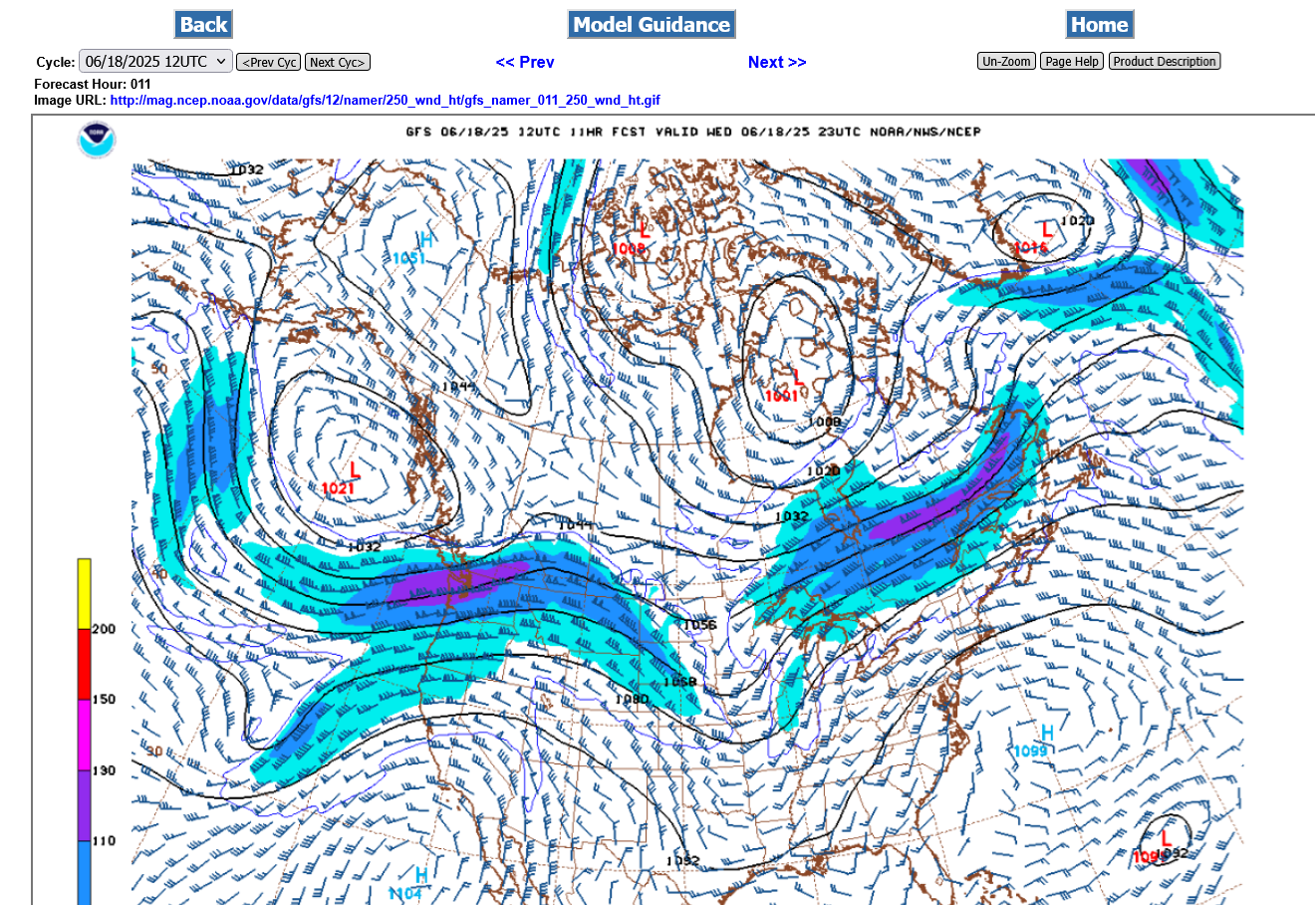
The upper level winds are NOT favorable for strong tornadoes on Wednesday but a weaker tornado is possible. This was the last 12z GFS model forecast for late Wednesday jet stream at 250 mb, which is around 32,000 feet up. Not real impressive in Indiana.
Excessive rain threat.
https://www.wpc.ncep.noaa.gov/qpf/excess_rain.shtml
Current Day 1 Forecast
Day 1 Threat Area in Text Format
Current Day 2 Forecast |
All the weather is here:
This link below provides some great data. After going to the link, hit "Mesoanalysis" then, the center of any box for the area that you want, then go to observation on the far left, then surface observations to get constantly updated surface observations or hit another of the dozens of choices.

https://www.wunderground.com/maps/radar/current

Found a great new link/site that shows us how much precip fell(from 1 hr to 72 hours) for different periods to share with you.
https://www.iweathernet.com/total-rainfall-map-24-hours-to-72-hours
Data Update Cycle: The 1-hr mosaic is updated every 5 min (approx). All other mosaics are now updated hourly, including the 48h and 72h maps.
The site does not allow me to copy the actual images/data here, as we do with all the other links above..........so just go to the link!
Recent rain amounts:
weathernet.com/total-rainfall-map-24-hours-to-72-hours
+++++++++++++++
Current Hazards at the link below.
For your NWS and county, go to the link below.
Then you can hit any spot on the map, including where you live and it will go to that NWS with all the comprehensive local weather information for that/your county.

Tracking the weather:
https://thermastor.com/dew-point-and-weather-maps/

Current Conditions below updated every few minutes.
UPPER MIDWEST
https://www.spc.noaa.gov/exper/mesoanalysis/new/viewsector.php?sector=13#


https://www.spc.noaa.gov/exper/mesoanalysis/new/viewsector.php?sector=13#

LOWER MIDWEST
https://www.spc.noaa.gov/exper/mesoanalysis/new/viewsector.php?sector=20

https://www.spc.noaa.gov/exper/mesoanalysis/new/viewsector.php?sector=20#

https://www.spc.noaa.gov/exper/mesoanalysis/new/viewsector.php?sector=20# 
SOUTHCENTRAL
https://www.spc.noaa.gov/exper/mesoanalysis/new/viewsector.php?sector=15#
SOUTHEAST
https://www.spc.noaa.gov/exper/mesoanalysis/new/viewsector.php?sector=18#

VORTEXjeff on X has some great stuff too:
https://x.com/VORTEXJeff?ref_src=twsrc%5Egoogle%7Ctwcamp%5Eserp%7Ctwgr%5Eauthor
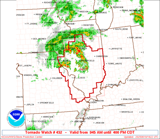
Tornado Watch until 4pm for IL. IN will be next, so expect a tornado watch to be issued this afternoon with 99% confidence.
I'm guessing storms will first get to Evansville around 3pm-ish!!
https://www.spc.noaa.gov/products/watch/ww0432.html
There is the risk of tornadoes later today but they are not likely to be violent tornadoes.
We cannot rule out a violent tornado when there's a tornado threat but the upper level jet stream and dynamics are unfavorable for violent tornado.
Does this matter?
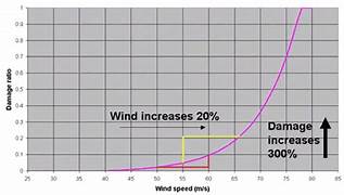
Absolutely it matters! A 150 mph tornado does 256 times more damage than a 75 mph tornado.
A 200 mph tornado would do 256 times more damage than a 100 mph tornado.
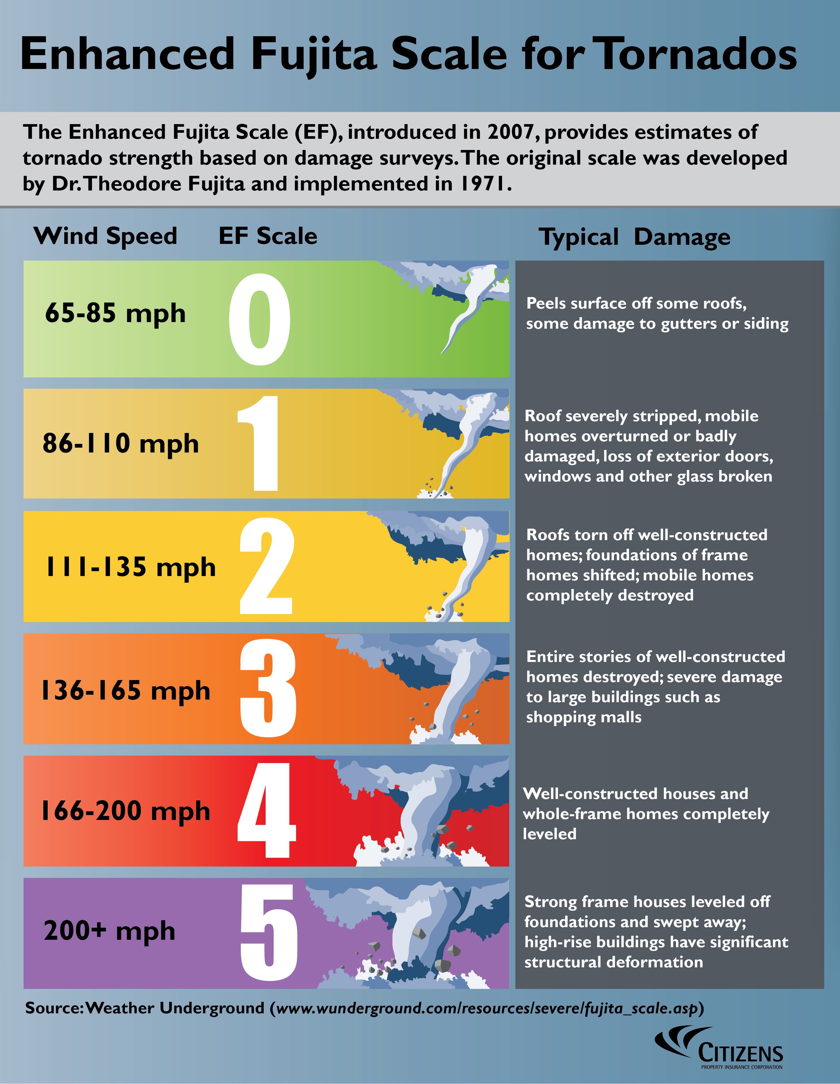
I would say that an EF2 tornado is possible today but EF3+ is unlikely but not impossible.
++++++++++++++++++++++
https://en.wikipedia.org/wiki/Enhanced_Fujita_scale
| EFU | Unknown | No surveyable damage |
|---|---|---|
| EF0 | 65–85 mph | Light damage |
| EF1 | 86–110 mph | Moderate damage |
| EF2 | 111–135 mph | Considerable damage |
| EF3 | 136–165 mph | Severe damage |
| EF4 | 166–200 mph | Devastating damage |
| EF5 | >200 mph | Incredible damage |
Here's the deal on wind and damage and why this tornado did not cause much damage
As wind increases the damage massively increases on an exponential scale. This applies to ALL wind.
Severe storms and hurricanes and especially tornadoes that have the strongest winds of all, which means the tornadoes with winds over 150 mph have incredible damage.
+++++++++++
+++++++++++++++++++++
A 150 mph wind does 256X more damage than a 75 mph wind. Let's repeat that. A 150mph wind does 256x more damage than a 75 mph wind!
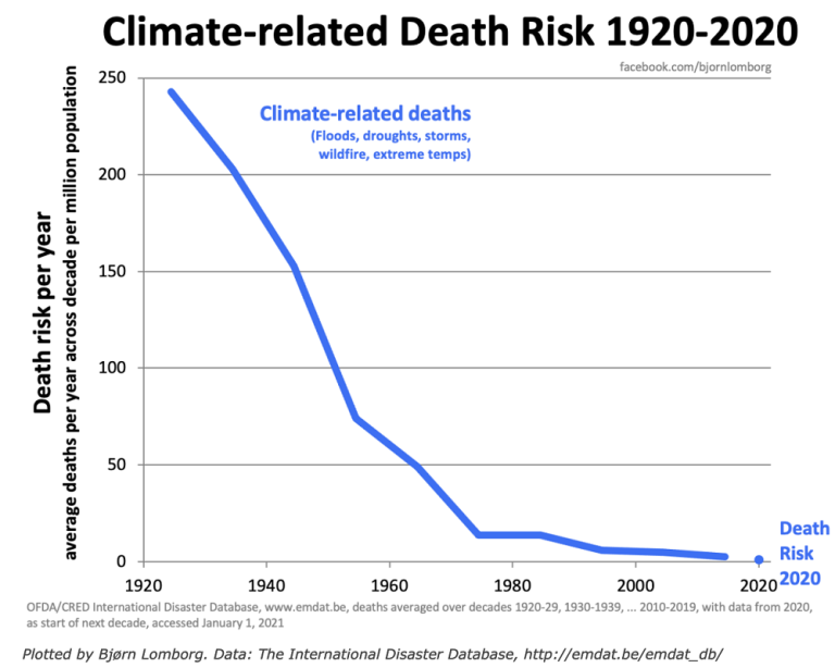
Less than 1% of tornadoes are F4 or F5 but they kill 67% of the people!
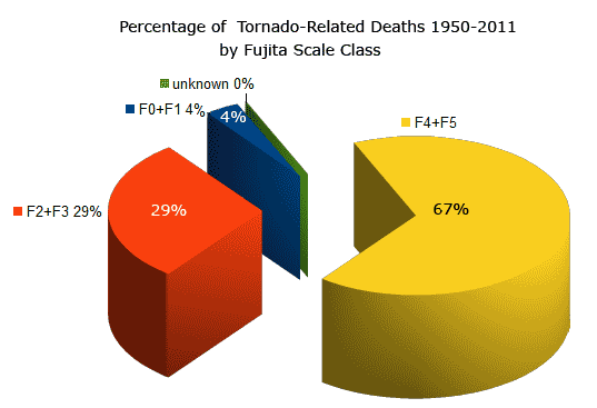
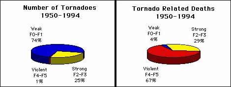
Note that the majority of tornadoes, F0 and F1= 74%(on the old scale) only killed 4% of people and they were probably outside or in a mobile home.
The F4 and F5's were just 1% but caused 67% of deaths.
++++++++++++++++++++++++
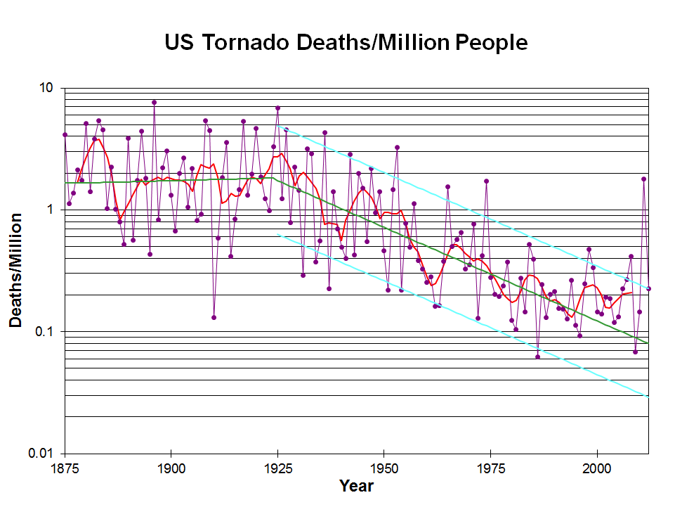
Knowing that a violent tornado may be headed towards your location, thanks to technology and being in a safe place is the main reason for this graph to show plunging fatalities from violent tornadoes. That 1 spike near the end was from the Joplin MO, tornado of 2011.
Note the drop that coincided with the start of the technology(radars and radio/tv communications, including weather radios).
The graph below is logarithmic. Tornado deaths today are around 10% what they were 100 years ago.
https://inside.nssl.noaa.gov/nsslnews/2009/03/us-annual-tornado-death-tolls-1875-present/
+++++++++++++++++++++++++++++
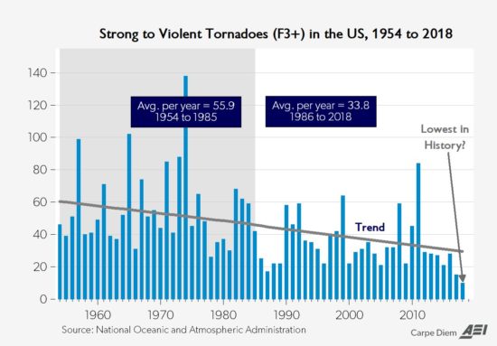
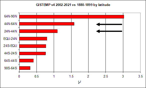
Another important authentic science/meteorology item is that climate change has REDUCED the number of violent tornadoes and tornado deaths.
https://www.marketforum.com/forum/topic/110407/#110432
Re: Re: Severe weather #2 May 7-8, 2024
By metmike - May 10, 2024, 12:11 a.m.
Why is this?
Meteorology 101 tells us what happens when the planet sees the temperature of the highest latitudes (coldest places, especially coldest time of year) warmed up the most. This is beneficial warming! Reduced meridional temperature gradient..........weaker cold fronts and jet streams.
Weather becomes LESS extreme in several realms!
+++++++++++++++++++
Put on your severe weather seat belts and enjoy the enlightenment and benefits of technology!!!
Don't be scared........be prepared!!!!
Regardless of the stats above, on days like today, we have the opportunity to save lives by going to our safest place in the event that a tornado WARNING is issued for your county. Most tornado warnings are for weak tornadoes, less than 120 mph that don't hurt anybody but do damage outside. The environment today is most favorable for that kind of tornado but we can't completely rule out something stronger.
Have your battery powered electronics charged up in case of a power outage!
Don't be scared...........be prepared!
We've had hundreds of severe weather events like this(some with a MUCH higher risk) in just the last decade.
The highest risk will be later today.
Though this is not a favorable set up for violent/killer tornadoes that most often occur in the Spring with a much stronger jet stream, this is a favorable set up for a widespread, damaging severe thunderstorm wind event.
The type of severe thunderstorm complex that could potentially develop later today is one where surface HEAT and very high dew points, along with a weak jet stream are present.
This is more like a Summer like severe weather event compared to a Spring like severe weather event (even though June can still feature Spring like conditions with a lingering strong jet stream).
And there is still a jet stream contributing wind sheer and the potential of tornadoes today, just not a strong one like we see with violent tornadoes outbreaks.
+++++++++++++++=
These were the storm reports from yesterday(when KS had an even higher risk). There will likely be an uptick in severe weather today.
https://www.spc.noaa.gov/climo/online/
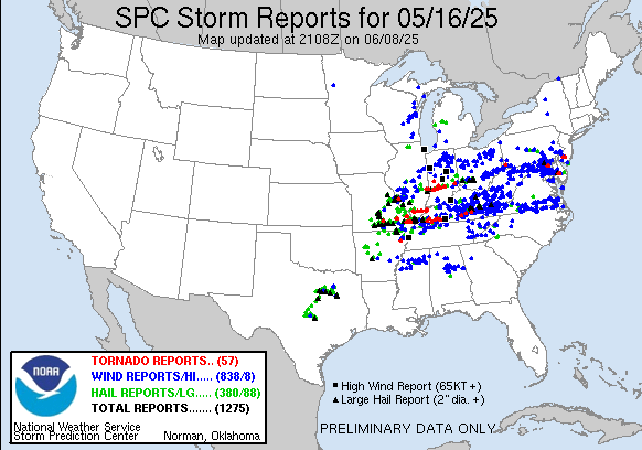
Let's compare that to our last MAJOR severe weather outbreak in May, just over a month ago, when we had a STRONG jet stream but less heat and lower dewpoints,. That huge outbreak, also featured some colder air which is often linked to the stronger jet streams.
https://www.spc.noaa.gov/climo/reports/250516_rpts.gif
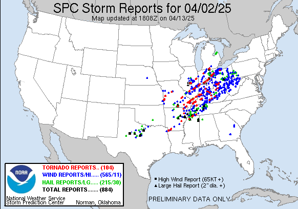
Here's the one from April 2, 2025 that resulted in a weak tornado crossing over our house.
https://www.spc.noaa.gov/climo/reports/250402_rpts.html
++++++++++++++++++++
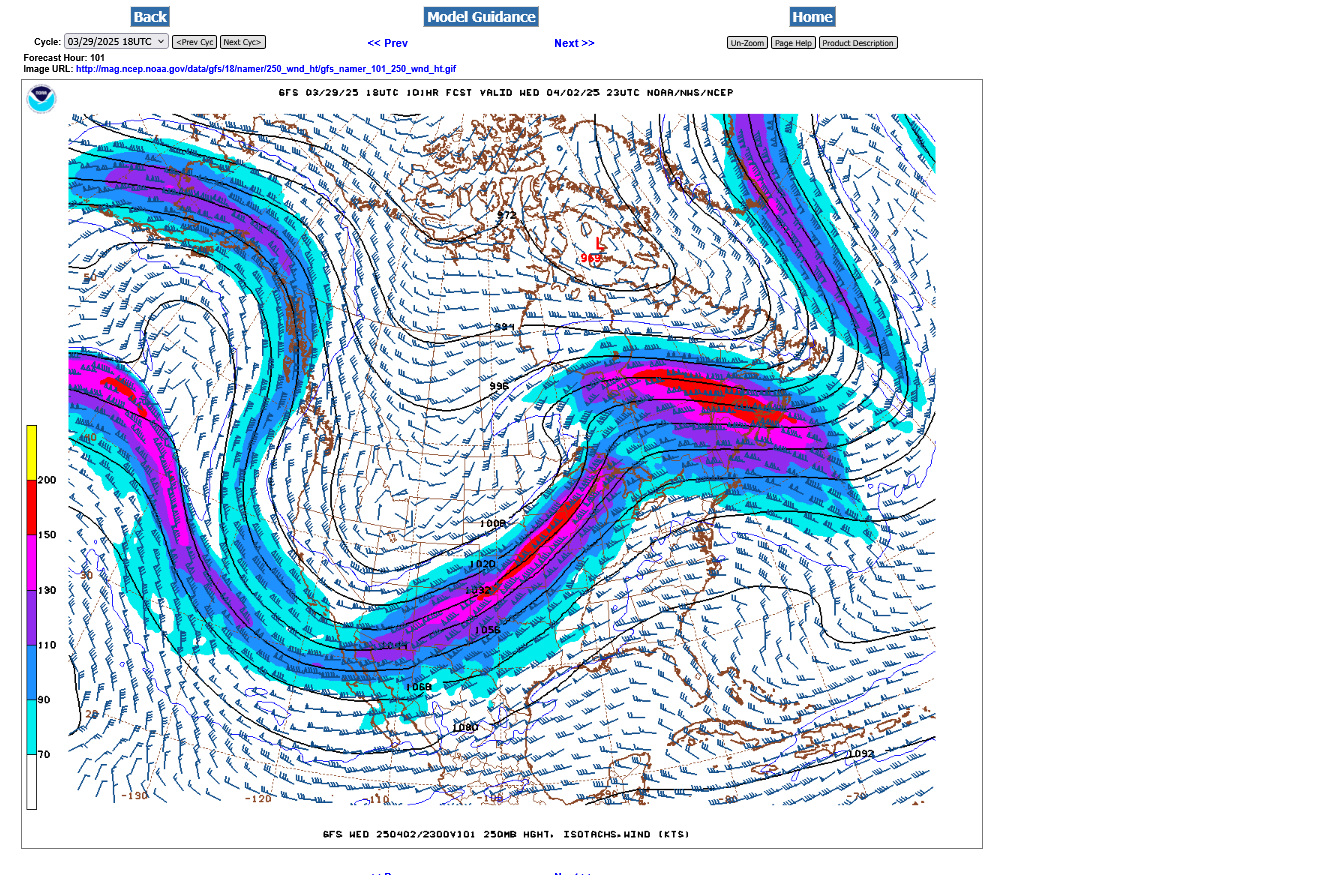
This is what the 250 mb jet stream looked like on April 2, 2025: 150+ mph jet streak
3-30-25 TORNADO outbreak on 4-2-25
Started by metmike - March 30, 2025, 3:08 p.m.
https://www.marketforum.com/forum/topic/110789/
Late Wednesday below. Classic, very powerful upper level jet stream for violent storms and tornadoes.
+++++++++++++++++++++++
This is our 250 mb jet stream later today: Well under 100 mph peak wind.
Weak tornadoes? Yes, one of those is possible.
Violent tornadoes? Probably not but still possible...especially north of us.
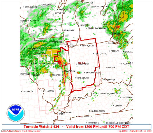
Here's the latest tornado watch box, just issued by the Storm Prediction Center until 7pm CDT:
They have a moderate risk of EF2+ tornadoes. I'm thinking less than that, especially here for a tornado that strong but its clearly possible.
https://www.spc.noaa.gov/products/watch/ww0434.html
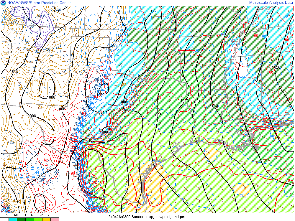
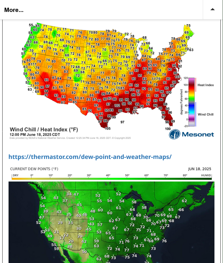
This is the current map for temps/heat index and dewpoints.
Around a 20 degree temperature contrast on either side of the system.
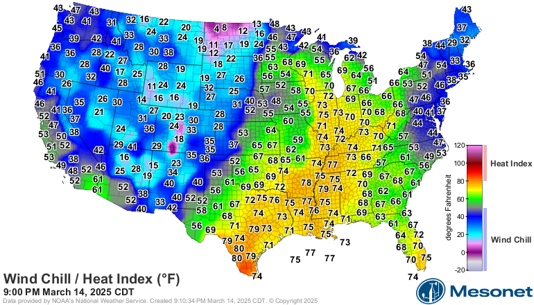
Compare it to the same SURFACE temperature map on March 14, 2025 with a strong jet stream and set up for potentially violent tornadoes. 50 degree temperature contrast on either side of the weather system.
Re: Tracking Severe Weather-3-14-25
By metmike - March 14, 2025, 10:09 p.m.
+++++++++++++++++++++++
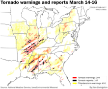
That one in March, caused this(that WON'T happen this time)
NWS for Evansville IN (out of Paducah, KY office).
Storms will be coming thru Evansville mid/late afternoon. 3-4pm-ish???


I'm blown away that the Storm Prediction Center did not issue a tornado watch for this part of Indiana a couple of hours ago. The watches are supposed to give people a couple of hours advance notice to prepare but these storm are almost here and no watch yet!
https://www.spc.noaa.gov/products/md/md1346.html
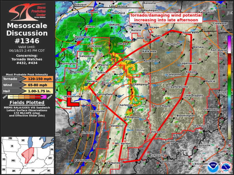
No indication from the SPC of an impending tornado watch but I'm almost certain is will happen because the strong storms are on our doorstep.
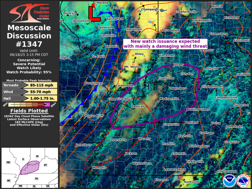
Finally a mesoscale update. This one good until 3:15pm.
95% of a watch coming soon. They agree with my earlier assessment that the main risk is from severe thunderstorms.
Their potential tornado strength is 85-115 mph so a weak tornado:
https://www.spc.noaa.gov/products/md/md1347.html
+++++++++++++++
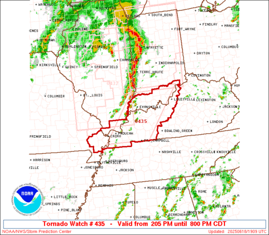
Instead of issuing a new watch box, they extended the previous watch box a few counties to the southeast where SEVERE WEATHER WAS ALREADY threatening. The watch is supposed to come hours before the warnings. This time, the watch came AFTER the immediate threat for those counties in IL.
Tornado Watch box just issued until 8pm.
However, the storms with the highest threat will be coming thru Evansville the next 2-3 hours or so.
https://www.spc.noaa.gov/products/watch/ww0435.html
https://www.spc.noaa.gov/products/watch/
Storms have developed in Southern Illinois early this afternoon. Storms are tracking to the north-northeast, while the line slowly advances eastward. Some of these storms will be strong to severe, with damaging winds the primary severe weather hazard.

2:18pm. Severe Thunderstorm Warning for northwest parts of Vanderburgh County. Storms got here faster than we thought earlier today/yesterday. No expected tornadoes even though an isolated WEAK tornado is possible.
Clearly, there's an upper level perturbation(outflow boundary from yesterdays storms?), not shown well on the models swinging thru right now that's triggering all these storms ahead of the main system. The back edge of these scattered but numerous storms will be going thru Evansville by around 3:30pm, then we may be quiet for several hours.
Possible additional storms developing later this evening associated with the main cold front. They will likely be weaker from the stabilized atmosphere left in the wake of these storms!
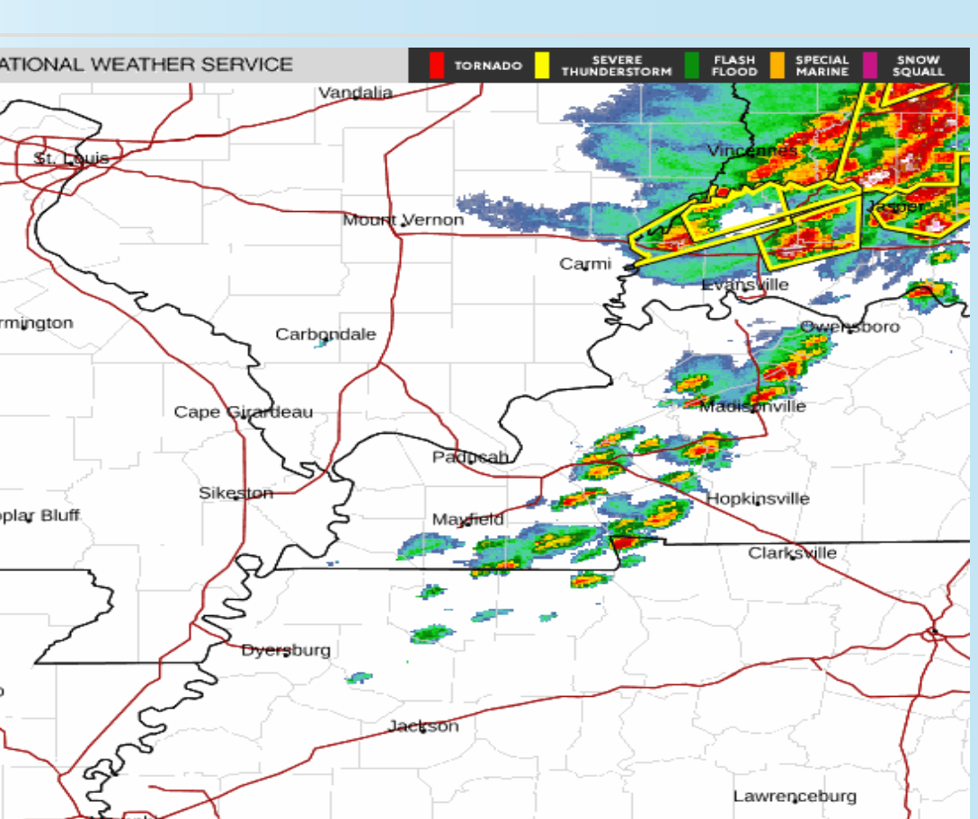
This is a freeze frame of the Evansville radar showing the numerous/widespread storms in IN, down to around I-64 right now. Just scattered weaker storms in KY around 3:25pm.
Note there is NOTHING to the west in IL, back to MO. So it will be quiet for at least several hours, until mid evening before new storms MIGHT develop ahead of the cold front. Those are also unlikely to have tornadoes, especially no violent tornadoes..
The tornado watch is still in effect until 8pm but it SHOULD HAVE been cancelled well over an hour ago.
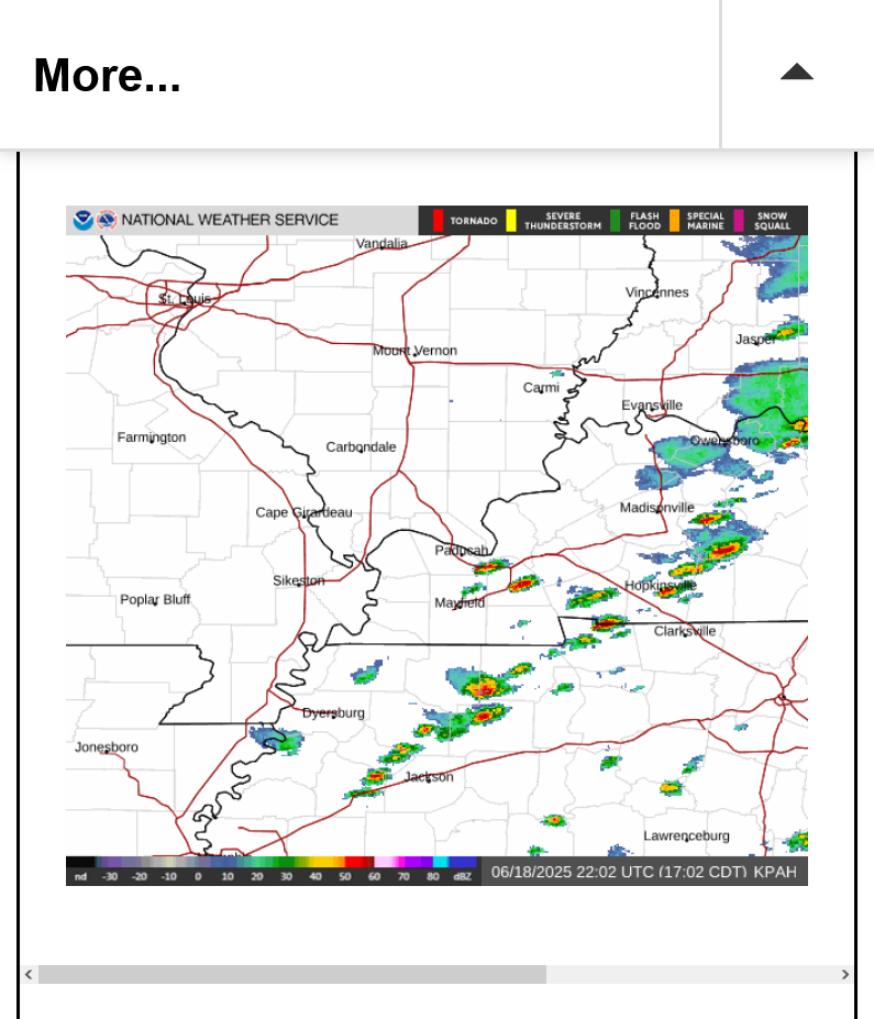
1. 5pm freeze frame. Storms are long gone.
2. Updated, live loop
5:30 pm: Tornado Watch finally cancelled!
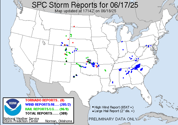
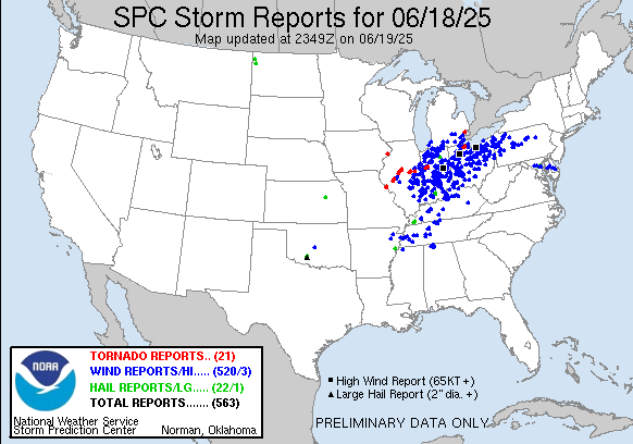
Severe storm outbreak for Wednesday, June 18, 2025.
520 severe storm, high wind reports.
21 tornadoes, all weak(EF-0, EF-1) and along the northern tier of the severe weather.
22 report of hail
https://www.spc.noaa.gov/climo/reports/250618_rpts.html
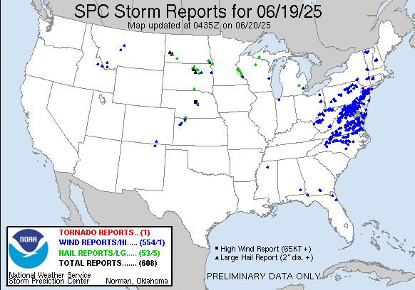
Severe Storm outbreak moves east on Juneteenth: