
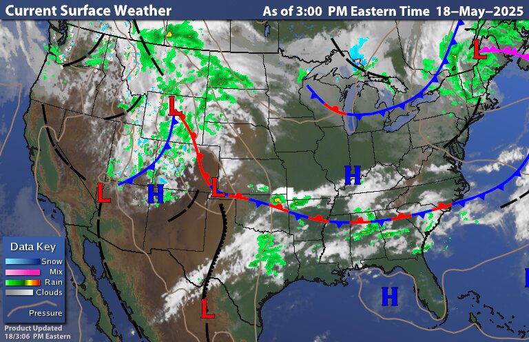
This weeks severe weather will happen much farther west initially, mostly in the central and southern Plains, today then weakening eastward.
However, the weather system will redevelop eastward on Monday/Tuesday and reconfigure the jet stream to establish a new threat. Not nearly as elevated a threat or as widespread as last week and farther south.
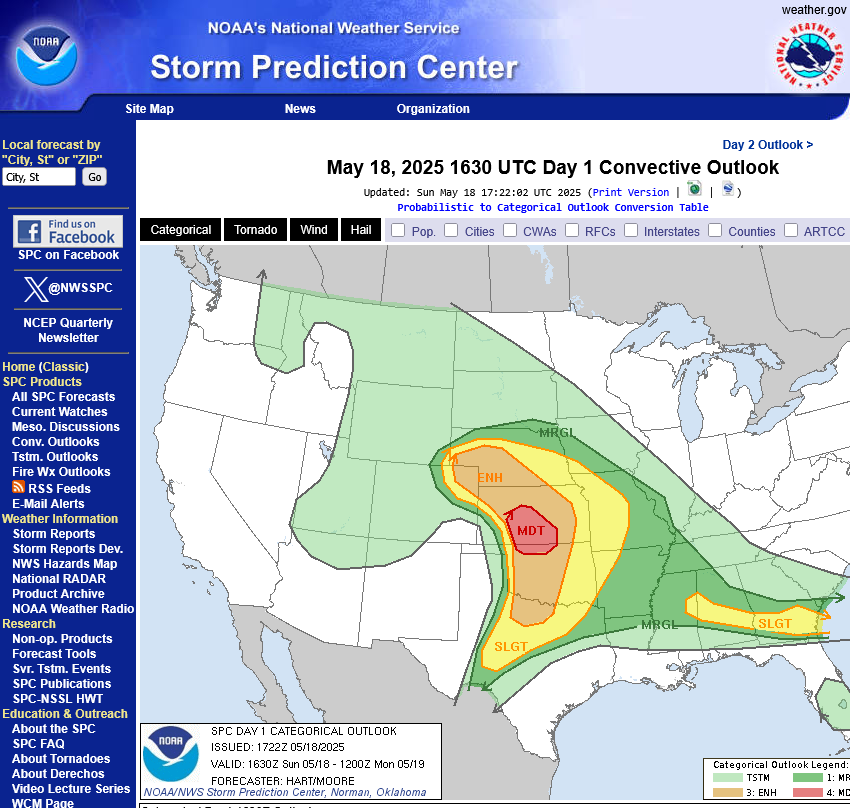
Day 1
https://www.spc.noaa.gov/products/outlook/day1otlk.html
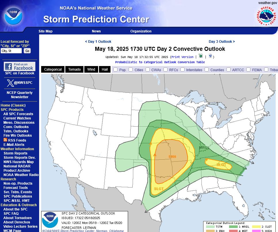
Day 2
https://www.spc.noaa.gov/products/outlook/day2otlk.html
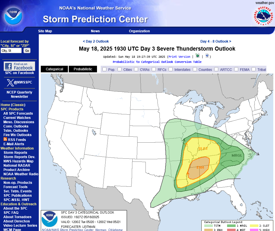
Day 3
https://www.spc.noaa.gov/products/outlook/day3otlk.html
Tracking the storms!

https://www.wunderground.com/maps/radar/current

Winter Weather Forecasts
https://www.wpc.ncep.noaa.gov/wwd/winter_wx.shtml
+++++++++++++++
Current Hazards at the link below.
For your NWS and county, go to the link below.
Then you can hit any spot on the map, including where you live and it will go to that NWS with all the comprehensive local weather information for that/your county.

New radar product below
Go to: "Select View" then "Local Radar"
Hit the purple circle to see that local radar site
+++++++++++++++++++++++
This link below provides some great data. After going to the link, hit "Mesoanalysis" then, the center of any box for the area that you want, then go to observation on the far left, then surface observations to get constantly updated surface observations or hit another of the dozens of choices.
 |
Current Conditions below updated every few minutes.
LOWER MIDWEST
https://www.spc.noaa.gov/exper/mesoanalysis/new/viewsector.php?sector=20

https://www.spc.noaa.gov/exper/mesoanalysis/new/viewsector.php?sector=20#

https://www.spc.noaa.gov/exper/mesoanalysis/new/viewsector.php?sector=20# 
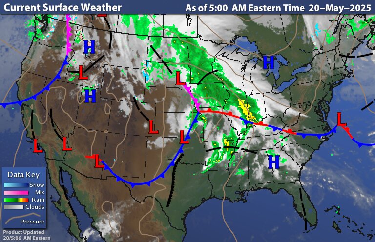
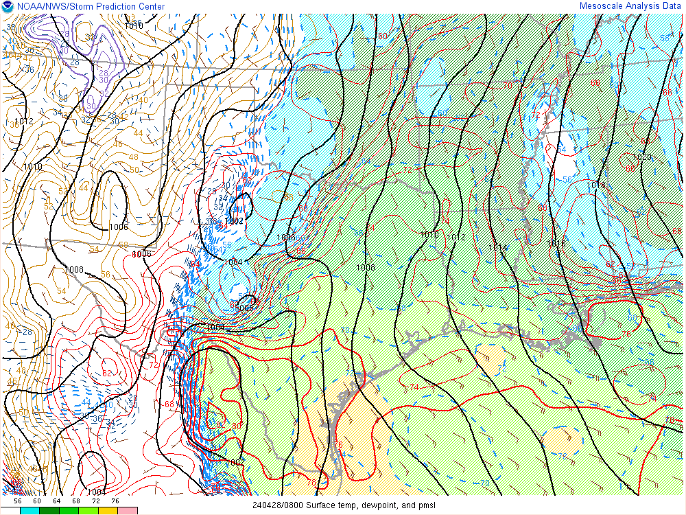
It's drawing up warm/humid air ahead of it with cold/dry air to the north. Temperature contrasts/boundaries feed storms and provide lifting/triggering mechanisms.
National Wind Chill / Heat Index
https://thermastor.com/dew-point-and-weather-maps/

Any rain in these events?
Plenty of rain this week, tjc.
Some of it exactly where its needed the most:
https://www.marketforum.com/forum/topic/83844/#83848
7 Day Total precipitation below:
http://www.wpc.ncep.noaa.govcdx /qpf/p168i.gif?1530796126

+++++++++++++++
A huge change in the last 2 weeks to the hot/dry Midwest forecasts that were in place in early May:
The last long range European model, thru July 3rd has cooled off even more and added more rains in the Midwest:
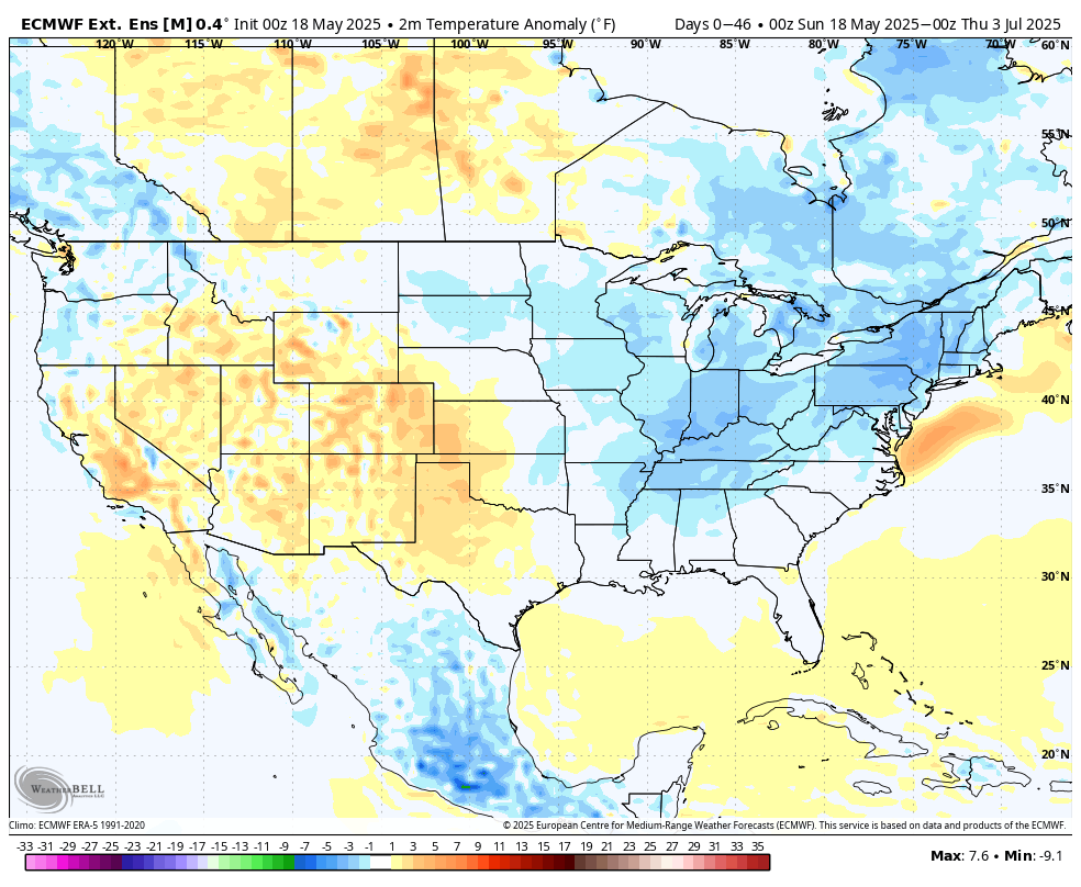
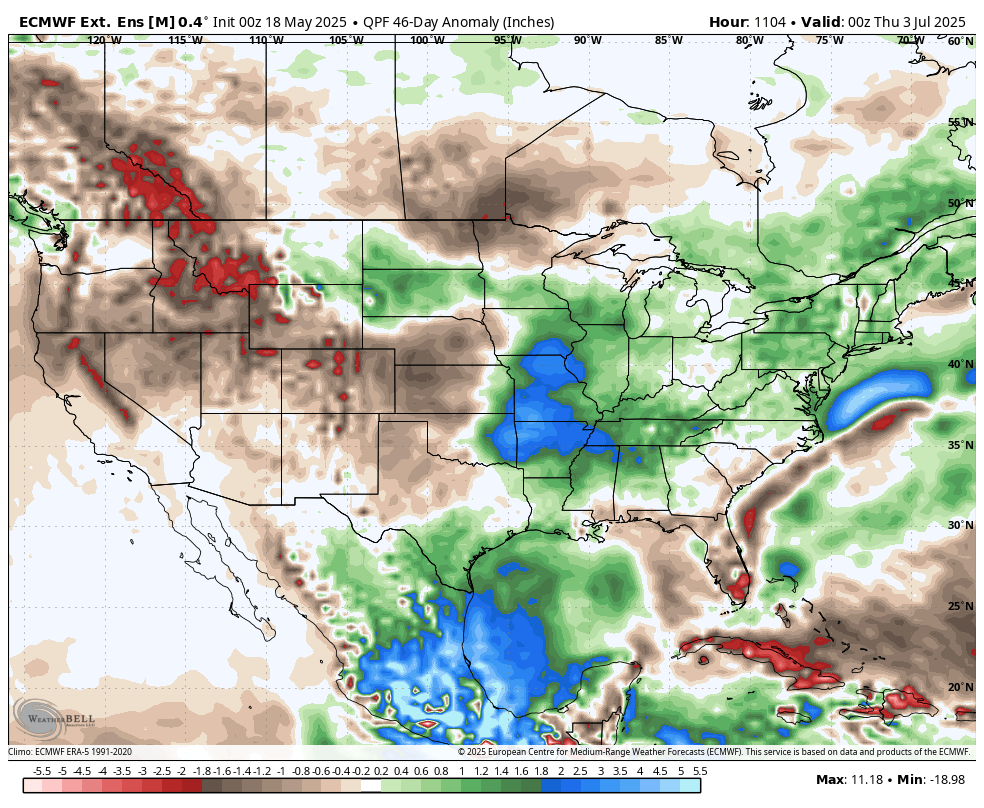
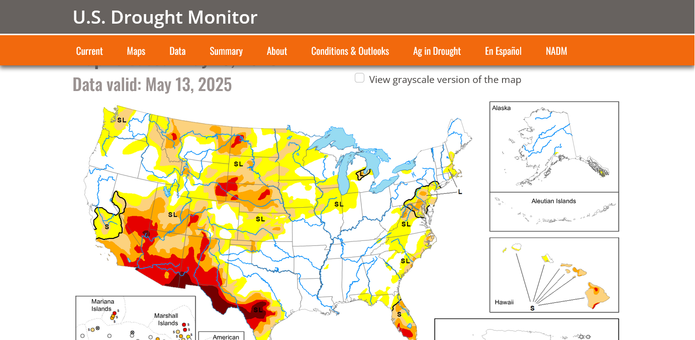
These are the areas that need rain. Midwest to North/Central Plains.
https://droughtmonitor.unl.edu/Maps/MapArchive.aspx
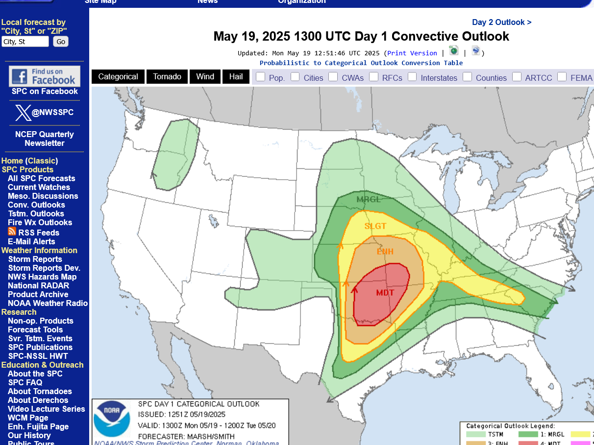
Updated risk maps from the Storm Prediction Center for:
1. Monday
2. Tuesday
https://www.spc.noaa.gov/products/outlook/day1otlk.html
https://www.spc.noaa.gov/products/outlook/day2otlk.html
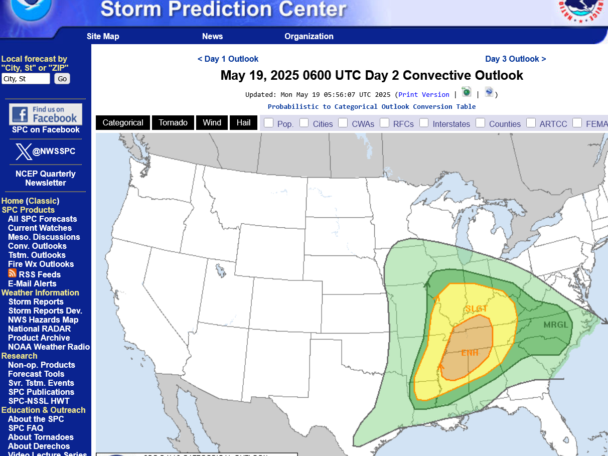
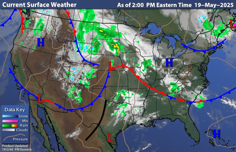
This is why I'm much less concerned about the severe weather on Tuesday/tomorrow compared to the last event 3 days ago.
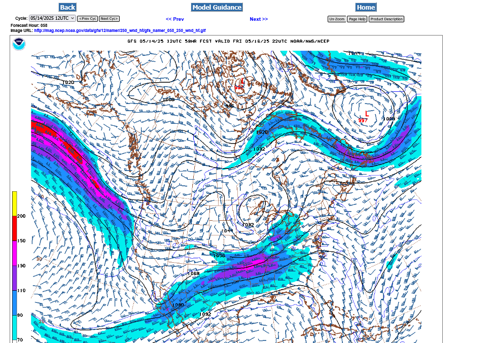
250 mb jet stream from last Friday, May 16, 2025:
https://www.marketforum.com/forum/topic/111845/

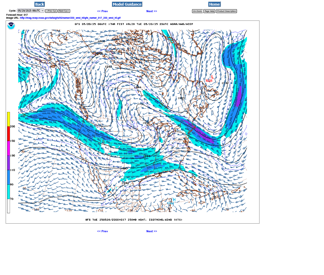
250 mb Jet stream forecast tomorrow on Tuesday, May 20, 2025 from the last 12z GFS model.
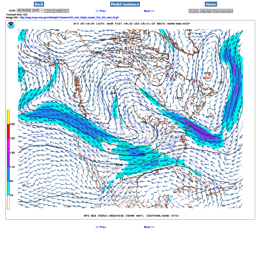
However, the trough in the 2nd image has what we call a negative tilt to it which enhances the lift, despite the lack of the very impressive jet max like in the 1st image which caused the widespread outbreak last Friday.
So there will likely be SOME severe weather ahead of the cold front and it could feature a few tornadoes, especially south of the Ohio River but an EF3 (and even an EF4 on 5-16) tornado is unlikely.
Those are the kind of twisters, along with EF5's that kill people.
ABC news was doing their usual sensationalizing, repeating numerous times tonight that this current system had already killed 26 people.
NO!
That was from LAST WEEK's weather system. This one is a completely different weather system.
OK, I was posting the weather updates in the wrong thread about Gaza and copied them below:
By metmike - May 20, 2025, 3:13 a.m.
Tornado Watch until 8am for southwestern IN
https://www.spc.noaa.gov/products/watch/
Severe Thunderstorm Warning for Vanderburgh County but storms don't seem that strong based on reports and from the WEHT Doppler radar.
Anything severe seems like it would just be an isolated wind gust of 60 mph.

OK, they either let the severe thunderstorm warning expire or they cancelled it early.
It's possible they will cancel the tornado watch until 8am early too.
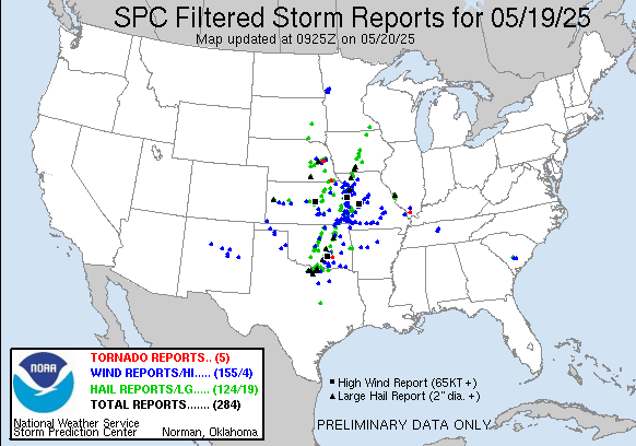
Lots of severe thunderstorm winds in the Plains. 5 weak tornadoes.
That activity greatly weakened moving eastward away from the main jet stream and stronger dynamics.
https://www.spc.noaa.gov/climo/reports/250519_rpts.html
Warm front triggering storms close to the Ohio River with a tornado watch but NO SEVERE WEATHER.
https://www.wunderground.com/maps/current-weather/mixed-surface-analysis
Severe weather risk on Tuesday. Highest is SOUTH of the Ohio River.
Tornadoes as strong as last Friday are not likely, even though the Storm Forecast Center is forecasting the possibility of strong tornadoes.
https://www.wunderground.com/maps/current-weather/mixed-surface-analysis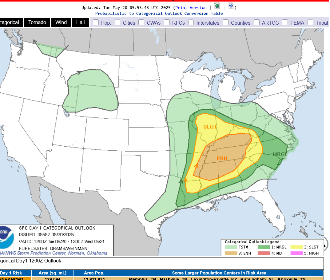
we can't completely rule out a couple of isolate strong tornadoes but the jet stream is just NOT powerful enough to generate strong tornadoes.
This is the forecast 250 mb wind for this evening from the just out 6z GFS:
A 100 mph jet streak in the middle of the jet stream. The type that can generate WEAK tornadoes with top winds of 110 mph or less.
Compare it to last Friday's jet stream during the major outbreak: A 150+ mph jet max, the type that spins up 150+ mph tornadoes.
As expected, they canceled the tornado watch 3 hours early for vanderbright county.
im surprised that it was issued to begin with.
This is the risk for the rest of the day. The main risk for a strong tornado is farther south in the enhanced zone.
https://www.spc.noaa.gov/products/outlook/day1otlk.html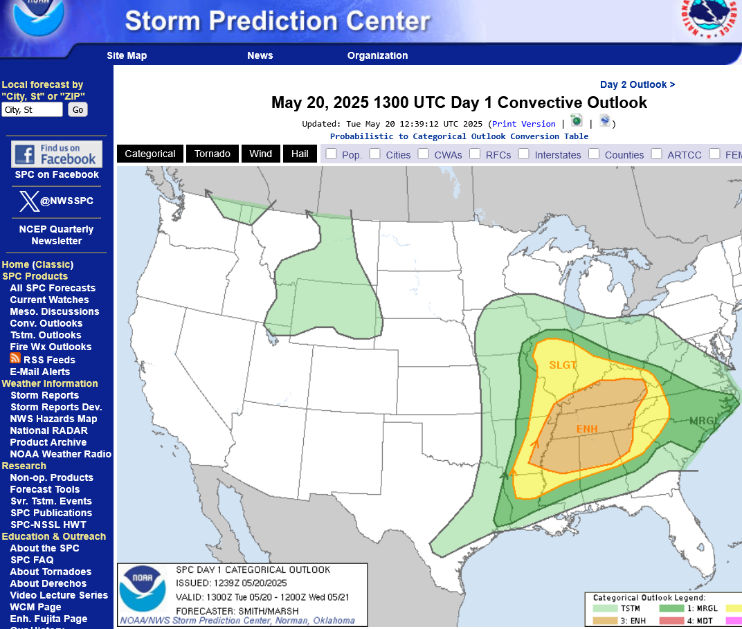
https://www.spc.noaa.gov/exper/mesoanalysis/new/viewsector.php?sector=13#
LOWER MIDWEST
https://www.spc.noaa.gov/exper/mesoanalysis/new/viewsector.php?sector=20
https://www.spc.noaa.gov/exper/mesoanalysis/new/viewsector.php?sector=20#
https://www.spc.noaa.gov/exper/mesoanalysis/new/viewsector.php?sector=20#
SOUTHCENTRAL
https://www.spc.noaa.gov/exper/mesoanalysis/new/viewsector.php?sector=15#
SOUTHEAST
https://www.spc.noaa.gov/exper/mesoanalysis/new/viewsector.php?sector=18#

Please use his page for the latest weather updates:
https://www.marketforum.com/forum/topic/111935/#111936
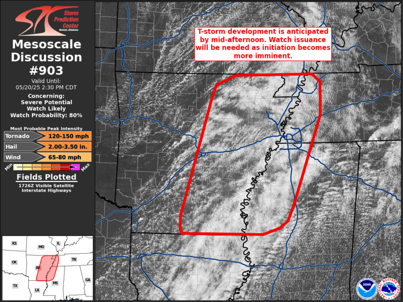
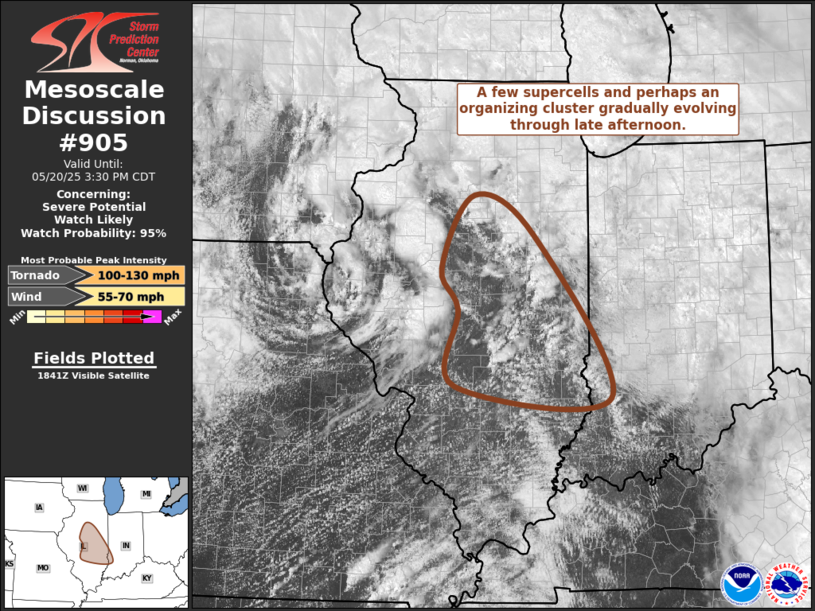
This is the area that initially will have the highest risk for severe storms and even a strong tornado
https://www.spc.noaa.gov/products/md/md0903.html
I have a speaking engagement tonight (talking to Troop 350 about the history of the troop) between 6:15p to 8:45p and will not be posting during that time.
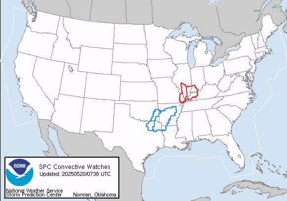
Tornado Watch just issued until 8pm CDT. Time stamps at Marketforum are in EDT.
https://www.spc.noaa.gov/products/watch/ww0303.html
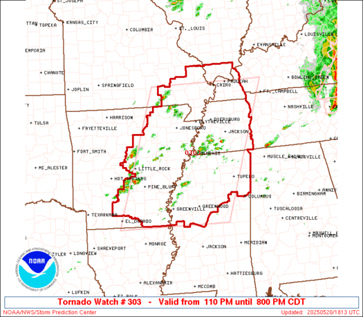
The Storm Prediction Center has a 40% chance of an EF2+ tornado in this watch box so that needs to be respected.
There will also be a risk farther north later this afternoon but just not as elevated for a strong tornado.
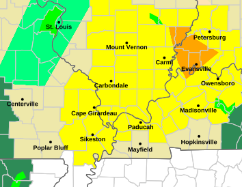
This tornado watch includes far southwest Indiana/Evansville until 10 pm. The storms will be past us before then.
They have a moderate risk of EF2+ tornadoes but I feel that is mostly south of Evansville.
However, take any tornado warnings very seriously and don't assume that I am right.
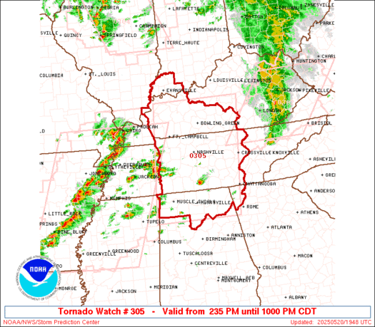
https://www.spc.noaa.gov/products/watch/ww0305.html
+++++++++++
Next watch coming up:
https://www.spc.noaa.gov/products/md/md0905.html
We can track the storms as they approach on the local radar the next 2 hours
Not much threat to Evansville or along the Ohio River from these storms as expected.
The line of strong storms is now passing SOUTH of Evansville in W.Kentucky and the threat for Evansville is over with this event.
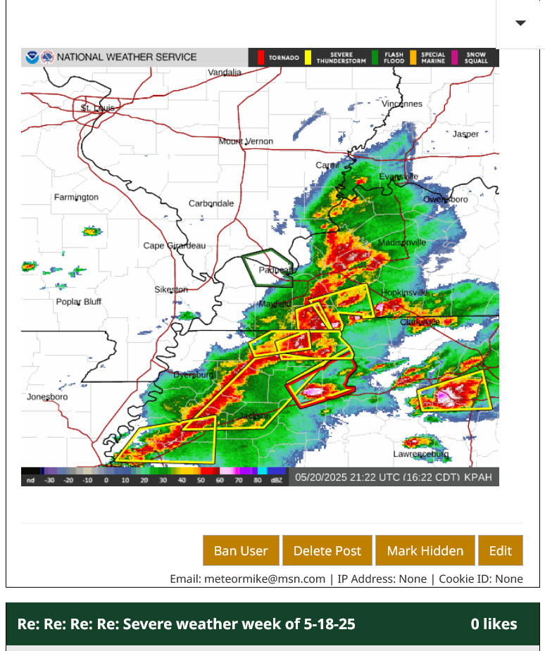
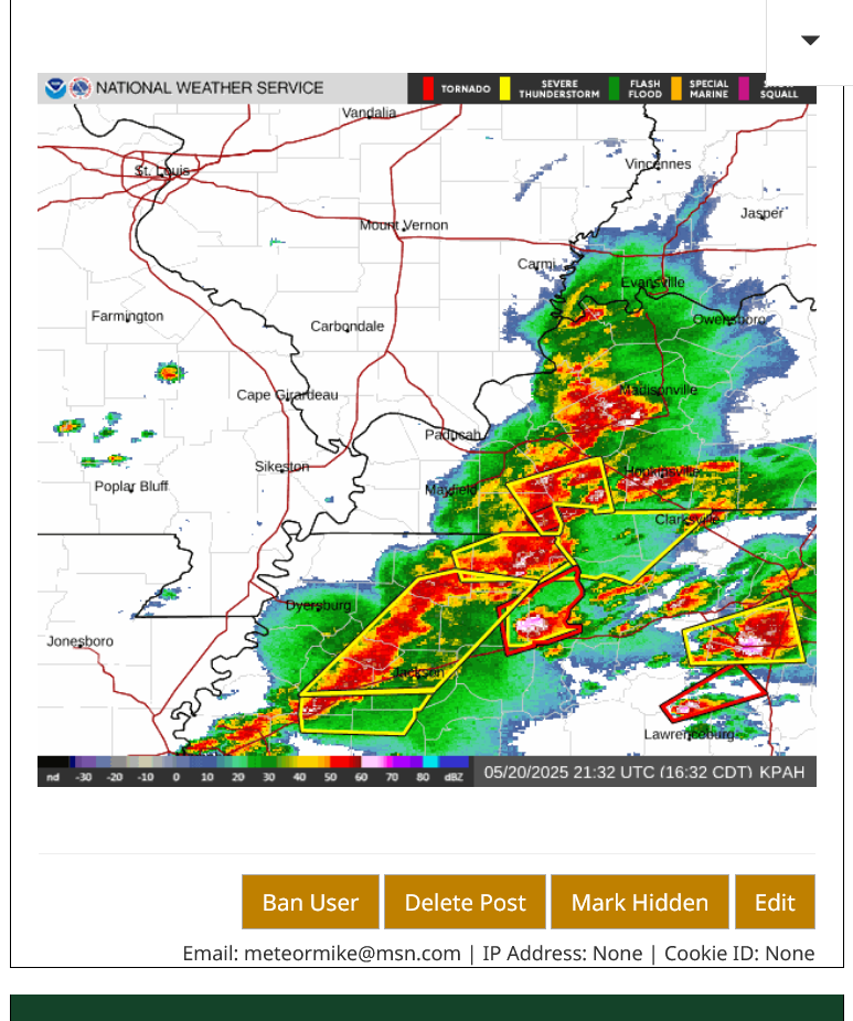
This was the radar image at 4:22pm with all the severe thunderstorm warning boxes in yellow, well to our south. 1 tornado warning box on the KY/TN border.
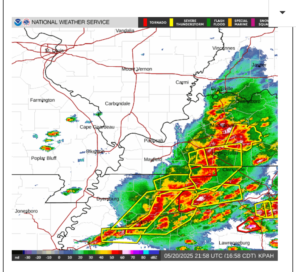
4:32 pm image below with another tornado warning in TN and the northern edge of the light/moderate rain that might have a bit of thunder/lighting barely to the Ohio River.
4:58pm image below: Severe thunderstorms in Western KY/TN continue moving east.
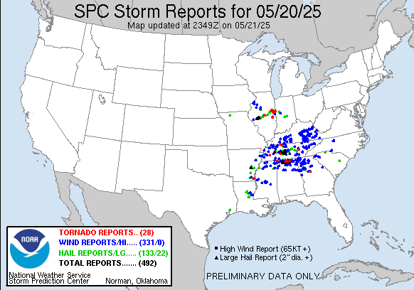
Severe weather reports just before 9pm.
KY and TN ane points just south got hit hard. Not much in IN. Another spot in central IL.
https://www.spc.noaa.gov/climo/reports/250520_rpts.html
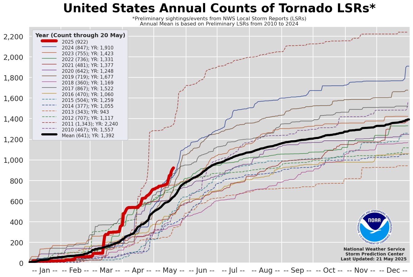
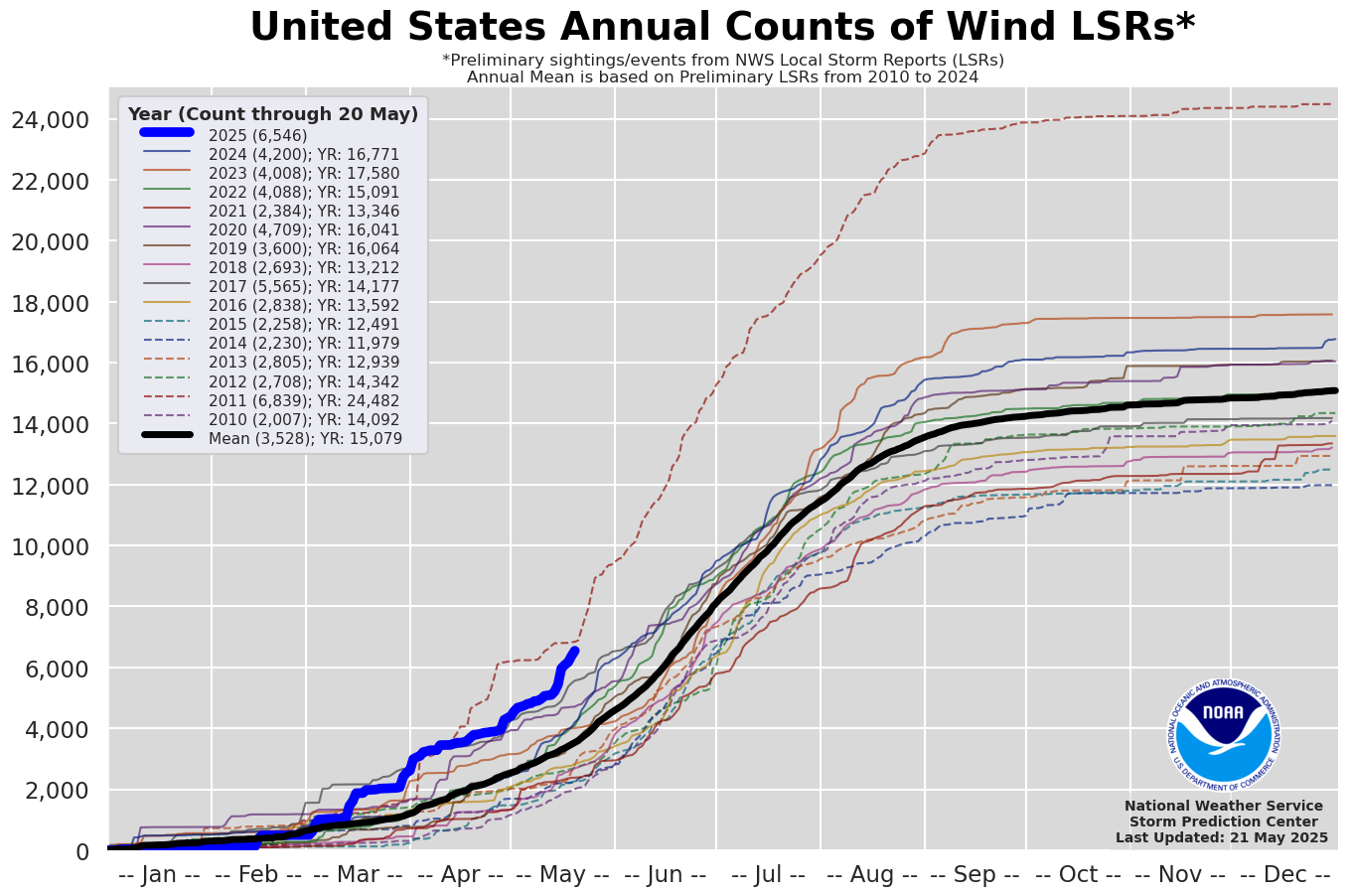
Total tornado count is high this year.
2011 is the record high by an extremely wide margin.
https://www.spc.noaa.gov/climo/summary/
Severe thunderstorm winds this year are close to the highest in the past 15 years:
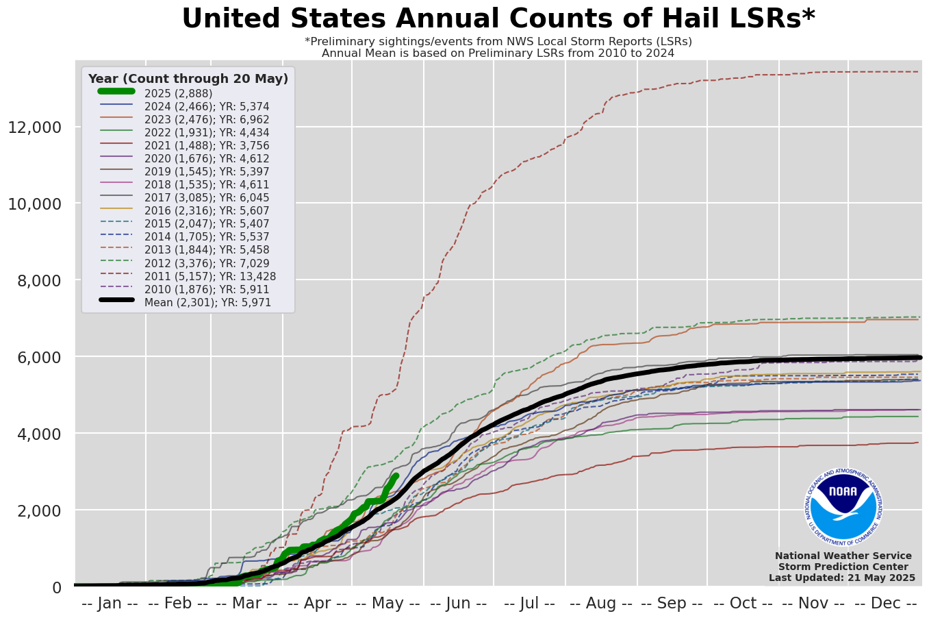
Hail reports in 2025 are above average but not extremely impressive:
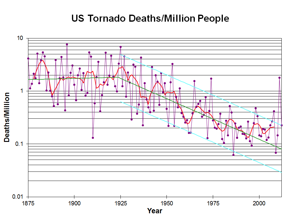
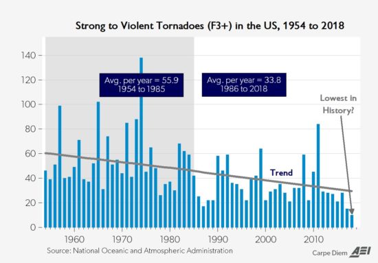
All these elements peaked in the 1970's during global cooling. We are recording MANY more weak tornadoes in this age, however thanks to the NEXRAD Dopper radars and better spotter coverage.
Before this age of technological advances we couldn't miss the strong tornadoes because they left a profound calling card in their wake!
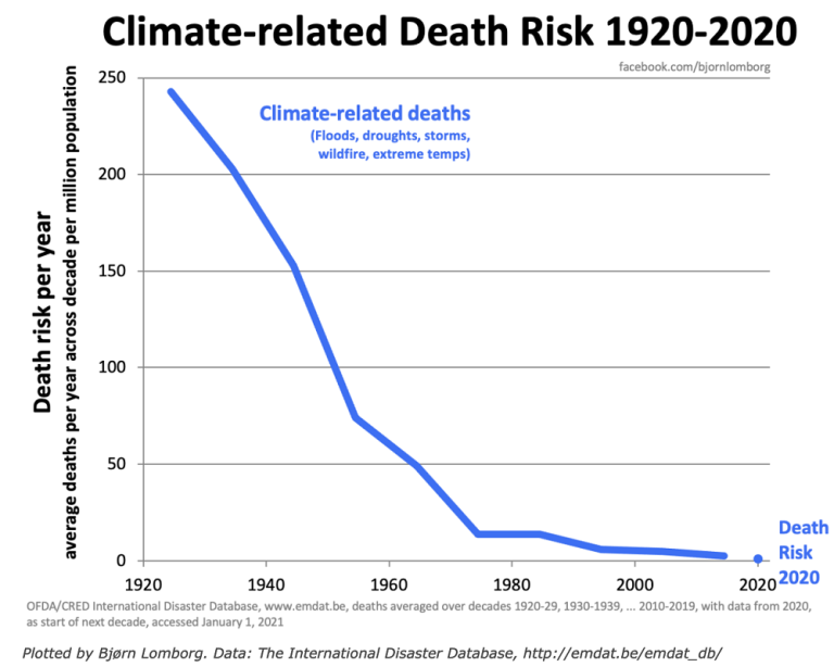
The graph below is logarithmic. Tornado deaths today are around 10% what they were 100 years ago.
https://inside.nssl.noaa.gov/nsslnews/2009/03/us-annual-tornado-death-tolls-1875-present/
+++++++++++++++++++++++++++++
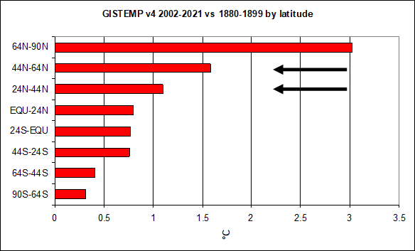
Another important authentic science/meteorology item is that climate change has REDUCED the number of violent tornadoes and tornado deaths.
https://www.marketforum.com/forum/topic/110407/#110432
Re: Re: Severe weather #2 May 7-8, 2024
By metmike - May 10, 2024, 12:11 a.m.
Why is this?
Meteorology 101 tells us what happens when the planet sees the temperature of the highest latitudes (coldest places, especially coldest time of year) warmed up the most. This is beneficial warming! Reduced meridional temperature gradient..........weaker cold fronts and jet streams.
Weather becomes LESS extreme in several realms!
+++++++++++++++++++
Put on your severe weather seat belts and enjoy the enlightenment and benefits of technology!!!
Don't be scared........be prepared!!!!
 Weather Map