I’ve been following the Key West (KW) buoy data closely again recently to see how it is comparing to last year. Keep in mind that this buoy’s water temp is legit since it’s over deep water unlike the buoys over shallow FL Bay/just S of the S tip of FL. During 5/15-18/24, KW water averaged an insanely warm 30.5C! That was warmer than 5/15-17/23, which was “only” 29.1C. And then today, KW avg rose to 31.0C! Last year around this date, KW started warming significantly and was up to 30.5C on 5/19/23. It didn’t fall back to that level til well into August just before which it peaked at 34.0C/93.2F (one reading on 8/10/23) with the 24 hour avg at 33.5C!
There is a coral reef in this deep water near and I believe just S of the Keys chain. It suffered severe, extensive, and very longlasting bleaching much of last summer. I’ll be closely following this again this summer. If the most recent water temps are any indication, it isn’t looking encouraging.
I KNOW "THEY'VE" BEEN REALLY PAYIN' ATTENTION TO THAT AREA. HOT, HOT, HOT!!
From met. Ben Noll, this is consistent with my own obs/post ITT:
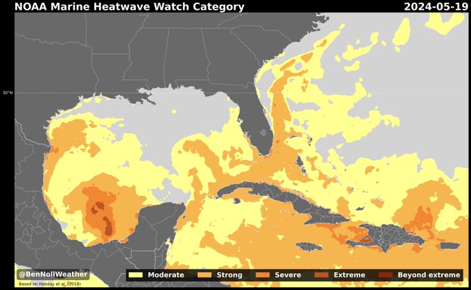
“A strong-to-severe marine heatwave has developed in South Florida's coastal waters amid the recent wave of noteworthy heat and humidity...The extremely warm water will likely form a positive feedback loop, with above average sea temperatures causing above average air temperatures and vice versa - a cycle that looks unlikely to be broken in the weeks ahead.
A pattern of persistent and strong high pressure over Mexico is driving the situation. When superimposed with the long-term warming trend, it creates some downright oppressive conditions.
Simply put, such widespread and severe marine heatwaves are a sign of the warming climate. They are only expected to become stronger and last longer in the years and decades ahead. This event is a glimpse at what the future holds. It's not just Florida that's being affected: a category 5 ‘beyond extreme’ marine heatwave is active near Port-au-Prince, Haiti, where it recently soared to 100˚F, a few degrees shy of the annual record. Santo Domingo, Dominican Republic, reached 101˚F this month, a degree shy of its annual record. The story has been similar for San Juan, Puerto Rico. Nighttime temperatures have been 5-10˚F above average in these areas, offering little or no reprieve from the heat.
However, these locations can't hold a candle to Campeche, Mexico, which had a 26-day run of high temperatures exceeding 100˚F from April 23rd to May 18th. This included a ridiculous 113˚F reading on May 17th and a low of 83˚F that night, qualifying as 13˚F above average for the day as a whole.
I hope these stats provide some context as to just how anomalous it's been out there. It's not just normal hot temperatures occurring in hot places: the upper historical bounds are constantly being nudged and we should really be paying attention.”
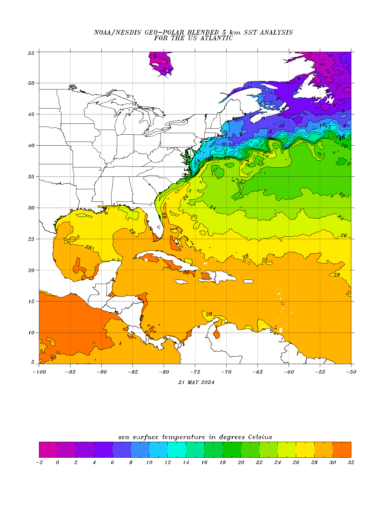
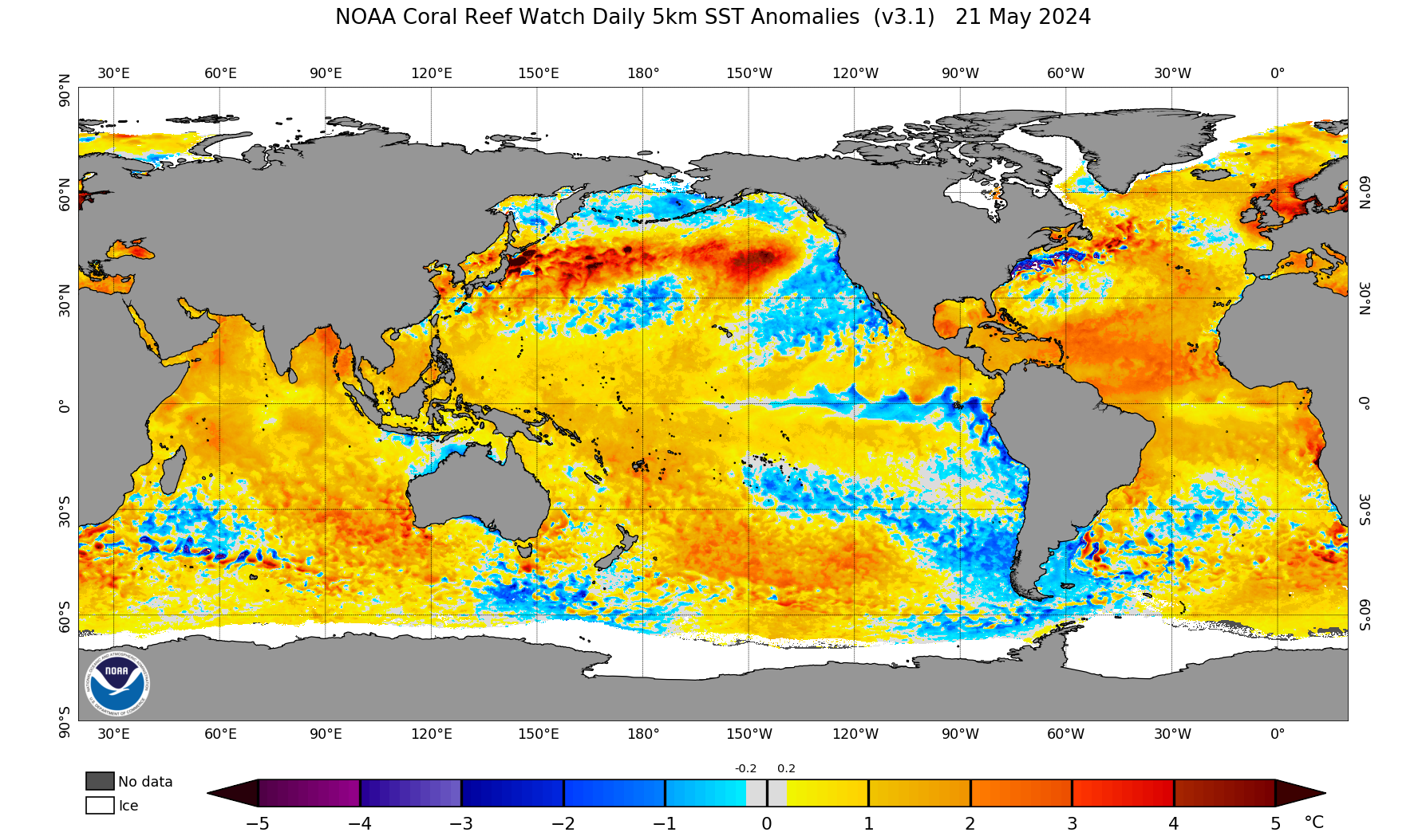
This shows the current warmth in the Tropical Atlantic.
Positive anomalies actually increased there in the last month.
Very warm tropical Atlantic + La Nina means very active tropical Atlantic Basin hurricane season.
Temps are easily warm enough for us to see a hurricane. Basically, 26 deg. C/79 deg/ F or warmer is needed.
https://www.ospo.noaa.gov/data/sst/contour/usatlant.fc.gif