MOST WEATHER MAPS ON MARKETFORUM ARE UPDATED FROM, BETWEEN EVERY FEW MINUTES TO EVERY DAY. THIS CAUSES MY DESCRIPTIONS OF THOSE MAPS FROM THE PREVIOUS DAY TO NOT CORRESPOND TO THE UPDATE SHOWING:
For instance, the Saturday Weather thread, now has maps which show updates from Sunday's latest weather, even though my descriptions are from Saturday.
The solution? I just start over with a new thread, "Sunday Weather" with new descriptions and new maps...............which will only be valid for Sunday.
Same thing for the other days of the week.
Something new to lead off. Main feature is the stalling cold front in the south(stationary front).
https://weather.com/maps/currentusweather

Here is the latest radar image. You can see the rains along that front.

Let's show something else new:

Rains the past 24 hours......lots of it in the East, South, Plains, N.Rockies ..........following the forecasts.![]()
You can go to this link to see rain totals from recent time periods:
https://water.weather.gov/precip/
Go to precipitation, then scroll down to pick a time frame. Hit states to get the borders to see locations better. Under products, you can hit "observed" or "Percent of normal".
Tons of rain across the key growing region. Some places in MN/IA/IL getting 8+ inches of rain in the last 2 weeks. This was actually a bit too much for the beans in those areas.
Most importantly........forecast rains.
Rains the next 7 days .........like a broken record....dumping on much of the country............... rain makes grain still but this pattern is going to change...........things will be shifting.
Day 1:
http://www.wpc.ncep.noaa.gov/qpf/fill_94qwbg.gif?1526306199054
Day 2:
http://www.wpc.ncep.noaa.gov/qpf/fill_98qwbg.gif?1528293750112
Day 3:
http://www.wpc.ncep.noaa.gov/qpf/fill_99qwbg.gif?1528293842764
Days 4-5:
http://www.wpc.ncep.noaa.gov/qpf/95ep48iwbg_fill.gif?1526306162
Days 6-7:
http://www.wpc.ncep.noaa.gov/qpf/97ep48iwbg_fill.gif?1526306162
Total accumulation
http://www.wpc.ncep.noaa.gov/qpf/p168i.gif?1526397762

Some areas have a threat for excessive rains.......moving back north as the heat ridge builds back north.
Current Day 1 Forecast Valid 15Z 06/11/18 - 12Z 06/12/18 |
Day 1 Threat Area in Text Format
| Day 2 and Day 3 Forecasts |
Current Day 2 Forecast Valid 12Z 06/12/18 - 12Z 06/13/18 |
Day 2 Threat Area in Text Format
Current Day 3 Forecast Valid 12Z 06/13/18 - 12Z 06/14/18 |
Severe Storm Risk. Use the link for full screen.
https://www.spc.noaa.gov/products/outlook/
Current Day 1 Outlook | Forecaster: Hart/Kerr Issued: 18/1240Z Valid: 18/1300Z - 19/1200Z Forecast Risk of Severe Storms: Slight Risk |
Current Day 2 Outlook | Forecaster: Bunting Issued: 18/0600Z Valid: 19/1200Z - 20/1200Z Forecast Risk of Severe Storms: Marginal Risk |
Current Day 3 Outlook | Forecaster: Bunting Issued: 18/0731Z Valid: 20/1200Z - 21/1200Z Forecast Risk of Severe Storms: Marginal Risk |
Current Day 4-8 Outlook |
Temperatures cooled off now thru the Midwest and Northeast......still comfortable on Sunday but warming in some places:


Highs days 3-7 shows pleasant temps Upper Midwest, blistering heat from C/S Plains to S.Midwest to East Coast and points south.


According to this fairly reliable indicator, from the GFS emsemble mean products, this is where the heat anomolies will be at the very start of July.........from the S.Plains to the Northeast.......near record heat:
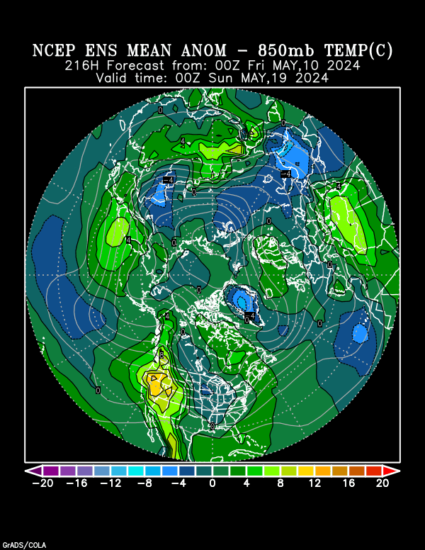
A week later, those heat anomolies have shifted farther west, with the dome backing up.......but the location greatly uncertain.
Cooler in the East(not cool but cooler) if this verifies.

CFS week 3 and 4...........turned MUCH cooler than it has been in a long time yesterday(after showing a strong intense heat signal before) which pounded Natural Gas but warmer today week 3.
In the state of flux and not a reliable indicator right now.

Precip below
NWS Experimental weeks 3-4: Hot and Dry from C/S Plains to S.Midwest!
| Week 3-4 Outlooks | ||
| Valid: 07 Jul 2018 to 20 Jul 2018 Updated: 22 Jun 2018 | ||
| Please provide comments using the online survey. | ||
Temperature Probability | Precipitation Probability (Experimental)  | |
NWS July-30 Day Forecast. Take this one to the bank(yeah, right bank"ruptcy).
You can access their other outlooks by going to the links in blue to the left of the map:
| OFFICIAL Forecasts | ||||||||
| July 2018 | ||||||||
| [UPDATED MONTHLY FORECASTS SERVICE CHANGE NOTICE] [EXPERIMENTAL TWO-CLASS SEASONAL FORECASTS] | ||||||||
| ||||||||
MetMike
Based upon this Saturday morning forecast, are you suggesting Sunday night will have grains start out (significantly?) lower with a possible probe of the 19th's LOWS?
TIA
Again, NG starts lower due to (relatively) cooler 10 day forecast (week 3/4 'proving' to be too unreliable)?
TIA
MetMike
Based upon this Saturday morning forecast, are you suggesting Sunday night will have grains start out (significantly?) lower with a possible probe of the 19th's LOWS?
TIA
Again, NG starts lower due to (relatively) cooler 10 day forecast (week 3/4 'proving' to be too unreliable)?
TIA
YW,
Actually, the 10 day forecast for ng is NOT cooler. It's the late week 2 and beyond part of the forecast thats turning cooler. Look at the anomolies above for that period and the last GFS model below. More heat for that period is not going to make that much difference, however if the market thinks we will get cooler after that.
The after that..............is the new pattern for July(or so the market can speculate) which matters the most. NEW news about the weather as far out as possible vs OLD news about near term weather(heat).
Are you short grains too?
Am not sure, except that the weather will need to be near perfect to challenge the lows. and that so much rain has fallen, an extraordinarily heavy amount for this time of year in the key areas, that a week of dry weather is beneficial.
We are in such an unusual situation, not just weather(that went from excessively dry to excessively wet in some areas) but with the China situation, prices collapsing and along with funds going from very long to piling on with shorts, along with what looks like potentially bullish fundamentals, that prices could be anywhere early next week.
The for sure thing, is that if the week 2 patterns starts to dry out and defines a new dry pattern that lasts for awhile in July, then prices will be higher in mid July than they are now.
Sorry,
Forgot to put the day 10 GFS 12z maps at the bottom earlier:
gfs_namer_240_200_wnd_ht | gfs_namer_240_500_vort_ht |
gfs_namer_240_1000_500_thick | gfs_namer_240_850_temp_ht |
Maybe should be obvious (but isn't too me), but what does the scale below the CFSv2 temp anomalies map mean? The scale goes from -3.5 to +3.5. Is that for the average daily temps (in Fahrenheit degrees) compared to normal for the week?
Similar on the precip map, it's scale -16 to +16. What are the units, mm? Or?
Thrilled that you are asking these questions pj!
It means:
1. Other people are wondering the same thing
2. It matters to you.
On the temps. If you look just above the temp maps, on the left side, you will see Anomalies (K). K is for the Kevin scale which is the exact same thing in anomalies as Celsius.
0 deg. K = -273.15 deg. C but anomalies is a relative measure not absolute so +4 deg. K is the same thing as +4 deg. C. Not sure why they use K other than its probably related to the numerical nomenclature used for the thousands of mathematical equations the computer model uses.
With regards to the precip. Yes, its in mm/day and listed at the top left of the maps.
I actually think that most people don't pay much attention to what the numerical values are as much as the shades of colors compared to other shades in a relative sense.
The darker and larger the size of the browns the hotter/drier it will be.
Greens are slightly wet or slightly cool. Blues are very wet or very cool.
I like their color scheme. Using it, one can understand alot about the weather over the entire country, looking for just a couple of seconds. How about you?
Of course its a period with low skill but still much better than flipping a coin.
There are things going on in the Pacific right now, for instance that can have a substantive effect on our weather....downstream beyond 2 weeks.
Still lots of other things that can disrupt or shift that effect or cut it off before the impact works its way downstream.
The NWS guidance, as expected for the last several days is beginning to dry things out in the extended period............first in the 8-14 day because of the new pattern evolving just after day 10.
6-10 day below
 |
Precipitation Probability |
8-14 day below
 |
Precipitation Probability |
The latest GFS sort of captures the essence of the predicted pattern change in week 2............a retrograding(backing up-moving west) of the dome/heat ridge............starting at around day 10 as a couple of huge chunks of upper level energy come crashing into it in the North/Central part of the US, digging into the Northeast and forcing the dome to reform much farther west, with a trough digging in, east of the new location.
Mike and tjc,
My feeling based on what I saw is that NG was down yesterday largely on a combo of a hangover effect from the prior day’s solidly bearish EIA report after it ended slightly higher on Thursday despite that report, crude oil having a HUGE up day, and perhaps helped a little by yesterday’s cooler 6Z GFS 11-15. I do not believe that the cooler week 3-4 CFSv2 had much, if any, influence because the market knows that those are extremely unreliable. As is often emphasized here, even late week 2 isn’t reliable and the market knows that. I really don’t think weeks 3 and 4 are much better than a coin flip, especially week 4. If it is reacting to the wx as its primary influence on any particular day, it almost always is reacting to the semi-reliable 2 week forecast changes.
Always appreciate your great thoughts Larry.
Yes, the end of the 8-14 was looking much cooler than it has in a long time yesterday and the week 3 and week 4 guidance that had amplified the heat for, I can't remember how many straight days, suddenly did an about face and followed thru with the late week 2 cooling.
NGI, in the morning had this as one of their comments:
"Some guidance into week 3 has begun to show that core ridging would shift into the Pacific Northwest and begin cooling the East, “a trend we expect to limit heat into the second half of July,”
Like you said though, it was a combination of things, especially the last 2 bearish suprise type EIA storage numbers.
Am thinking that they are really cranking up the supplies as you have noted, frequently happens when storage is low.
With regards to week 3. In this case, I think that since it matched up very well with the end of week 2's pattern change that it earned a bit more credibility than usual.
As we have often seen with many markets, they can spin the effect news the way they want based on trader or market bias.
In a strong bull market, the same news is traded and interpreted different than if it was a strong bear market.
Also, I mentioned on Thursday that the downside risk seems greater because the market has been fed widespread heat in the extended forecast for a very long time. For the extended forecast to even more bullish, would require really extreme heat. ..........and that could happen. However, to get pretty bearish, all we need is normal temperatures or even slightly above vs the much above we have been trading is still bearish.
If temps actually shift to below normal in the Eastern or Southern parts of the country during July, along with supplies cranking, we could fall pretty hard.
Thanks for the explanation. Like I said I should have been able to figure it out.
Thanks also for all your work as moderator. You must be gratified to see that it seems like the number of posts is starting to climb.
FYI I was asked to login both times I posted.
YW pj,
It's good to see things pick up.
Would like to see it happen much faster

