We have some very chilly weather coming up next week but probably not quite cold enough to do freeze damage. The crop is advanced/mature ahead of average(early planting and warm Summer), so to do damage this year, a freeze would need to happen this early.
If temps did drop to below freezing, some 6-10 degrees colder than the current forecast, it would do serious damage.
A freeze in late September is probably not going to result in that much damage here in 2020.
Crop conditions week of Aug 31, 2020
https://www.marketforum.com/forum/topic/58454/
We have 3 big freezes in the last 45 years.
Early Sept 1974 must have been great damage to both corn and beans
Sept 15, 2011 mainly beans
Sept 23-25 1995 did damage, mainly beans only because of the late planting in IL/IN.
Thats 3 times in 45 years, the last 2 mainly to the beans, and the last one only because we planted in IL/IN well into June.
Previous posts on this:
Note that the first freeze in the Upper Midwest averages the last week in September.
The first freeze dates in the Eastern Cornbelt are 10+ days later. Early October in the colder spots, mid October in much of the rest of those locations. This will not do alot of damage with a warm August.
Average freeze dates this year are not going to do much damage to the 2020 crop.
https://www.weather.gov/iwx/fallfrostinfo
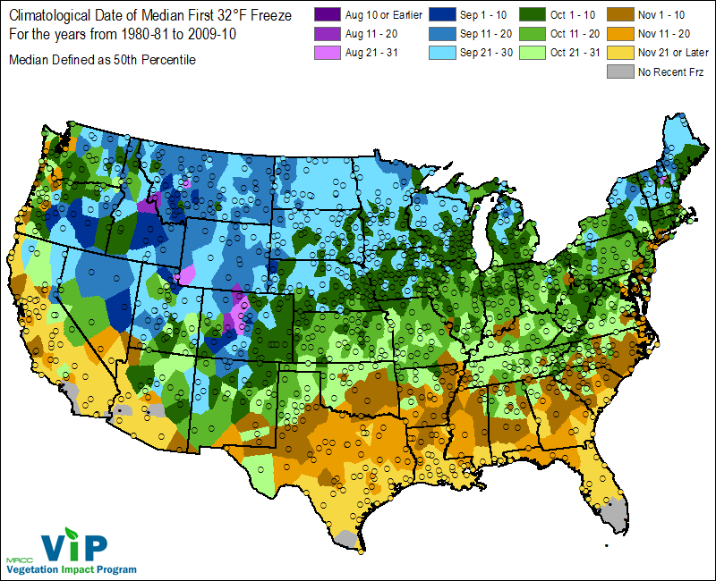
Fig. 1. Climatological Date of Median First 32°F freeze for the United States.
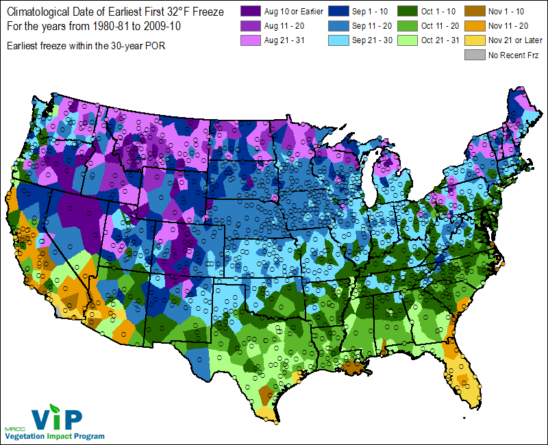
Here are the earliest freeze dates since 1980............so this data did not include an earlier one in 1974.
A very rare freeze has happened before along the Canadian border as early as late August. This would be mainly Hard Red Spring wheat country. The HRS crop was actually planted on time this year.
If this map included 1974 in some places in the Upper Midwest, it would have the dark/navy blue shade for early Sept. instead of the medium blue, which is Sept 11-20.
Very rare first freezes have happened in the Eastern cornbelt in the coldest places in mid Sept with most spots having late Sept. The 1995 Sept HARD freezes that went down to the Ohio River were actually Sept. 23/24. That would hurt the beans for sure this year and possibly the corn if its cool between now and then.
Again, these are rare events, maybe once every 15 years to get that cold so early.
To really do some damage, we would need temps to get this cold:
https://www.weather.gov/iwx/fallfrostinfo
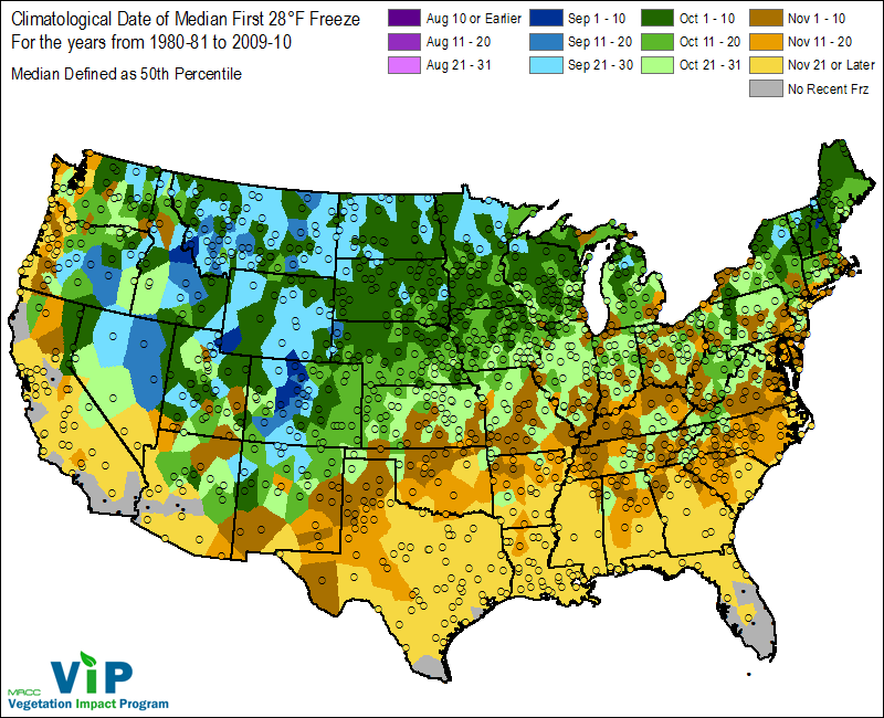
Fig. 7. Climatological Date of the Median First 28°F freeze for the United States.
We have 3 big freezes in the last 45 years.
Early Sept 1974 must have been great damage to both corn and beans
Sept 15, 2011 mainly beans
Sept 23-25 1995 did damage, mainly beans only because of the late planting in IL/IN.
Thats 3 times in 45 years, the last 2 mainly to the beans, and the last one only because we planted in IL/IN well into June.
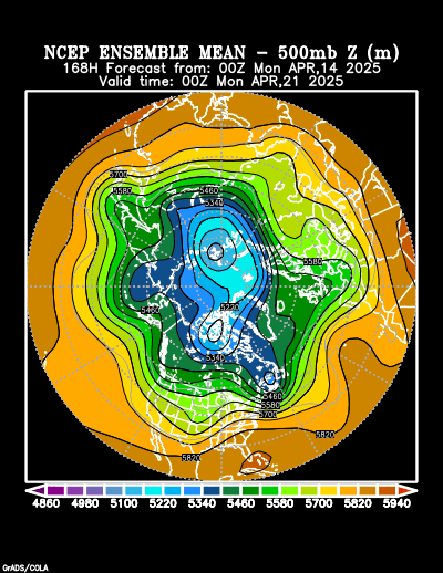
You can go back to look at the weather maps for those freeze events using this link. This is the one from early September 1974. This is the 500 mb map below.
https://psl.noaa.gov/data/composites/hour/

Current forecast for 500 mb for 1 week out.
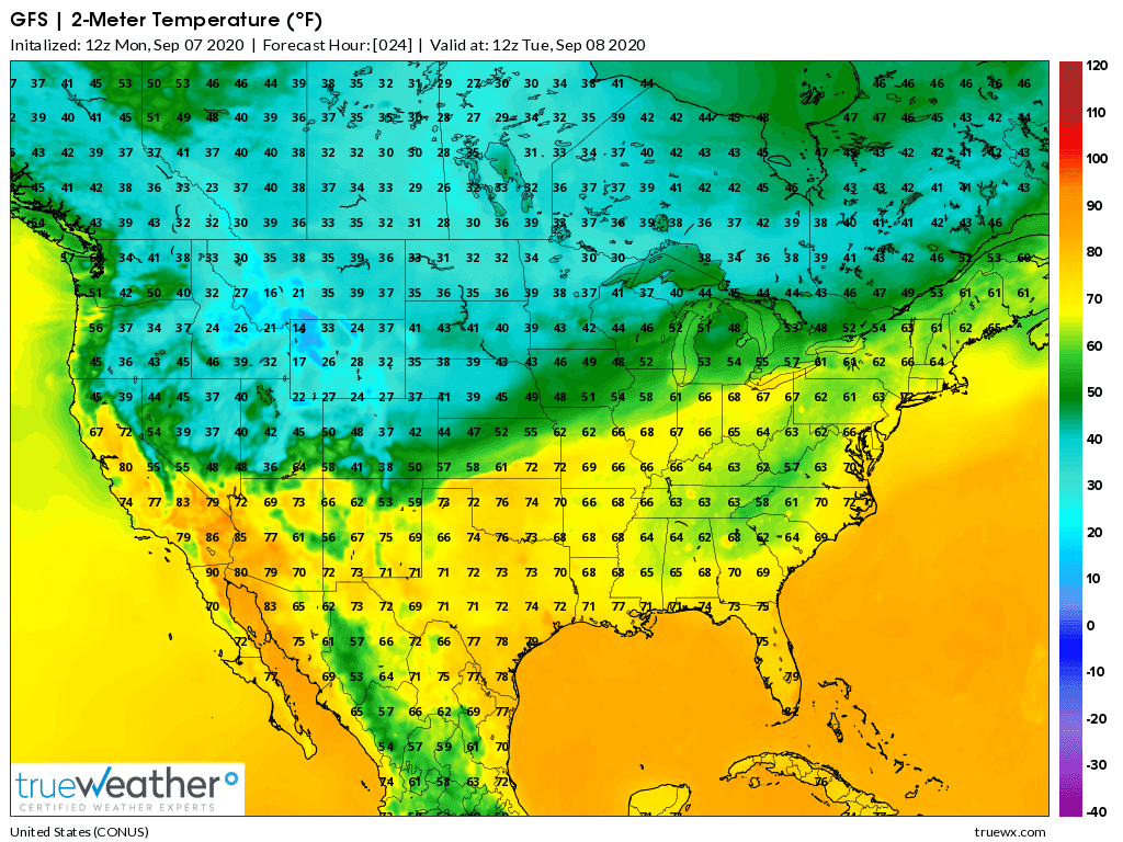
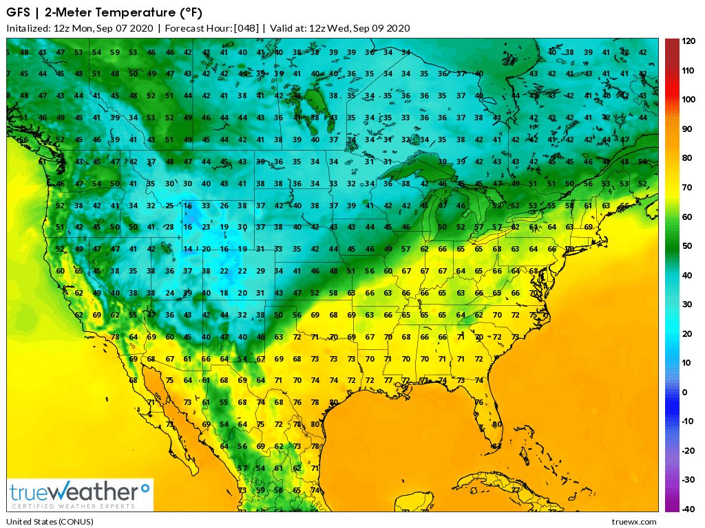
Around freezing in the High Plains on Tue/Wed.
GFS lows days 1-3 below:
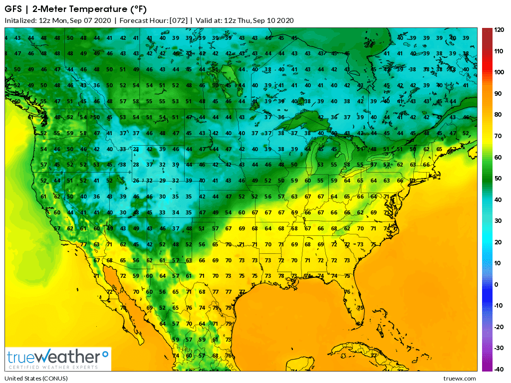
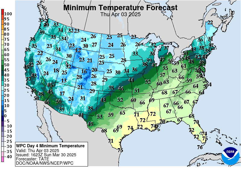
Lows days 3-7 below:
https://www.wpc.ncep.noaa.gov/medr/medr_min.shtml
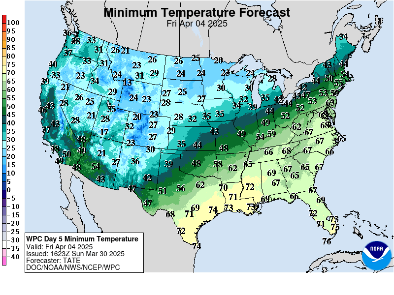
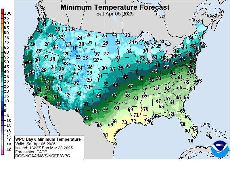
Daily low temperatures for days 3-7 below:
https://www.wpc.ncep.noaa.gov/medr/medr_min.shtml


30's in the Plains for a couple of mornings next week but not quite cold enough for damage.
Maybe close to freezing in the high N/C High Plains next Tue/Wed
Great stuff Mike. Thanks
YW Jim!
Still looks like close to freezing in the High Plains on Tue/Wed but no major damage.
I could see some minor losses in the N/C Plains in the low lying areas for beans but not much more than that.
There are several farmers with green soys and corn with 1/2 to 2/3 milk line
These acres are at risk, however farmers never look at a glass 1/2 full
Neb all the way north has acres at some risk, but probably more in the eye of the beholder than real risk
The fact snow is forcast has rattled some cages
Texas at high altitudes is at risk
Update low temp maps to include days 1-2, since the cold blast in getting closer.
Still looks like some freezing temps in the High Plains.
Updated latest temp forecast for lows this week.
Still looks like the High Plains and also far N.Plains/ND will see temps around freezing.
This could result in some minor damage to low production areas.
929 AM CDT Mon Sep 7 2020 /829 AM MDT Mon Sep 7 2020/
This Hazardous Weather Outlook is for portions of north central North Dakota, northwest North Dakota, south central North Dakota, southeast North Dakota, and southwest North Dakota.
.DAY ONE...Today and Tonight
A Freeze Warning is in effect late tonight through Tuesday morning. See weather.gov/bis for details.
.DAYS TWO THROUGH SEVEN...Tuesday through Sunday
A Freeze Warning is in effect late tonight through Tuesday morning. See weather.gov/bis for details.
There is potential again for sub-freezing temperatures Wednesday morning. A Freeze Watch is in effect for this period.
Monitoring temperatures as they drop tonight. Already a bit below freezing in several locations of ND and at freezing in a couple spots of far W.SD/NE.
Looks close to the forecast, with some damage to beans in some, low lying fields(from cold air drainage) mainly low production areas.
Tonight will be the coldest night/early morning.
