Heat is still the top story!
Heat coming to the Midwest then moves east.
Highs Sun-Thu below


National Radar Loop: Big rains in IA pressuring corn this morning
https://radar.weather.gov/Conus/index_loop.php

Rains the past 24 hours........IA, #1 corn producer! ![]()
This 4 week rainfall map shows mostly what it looked like before alot of the bountiful rains fell:

Rains hit some of the driest spots!
You can go to this link to see rain totals from recent time periods:
https://water.weather.gov/precip/
Go to precipitation, then scroll down to pick a time frame. Hit states to get the borders to see locations better. Under products, you can hit %normal.
You can see how the big dry pockets.........shrank but there are still dry spots right now. Since the crop ratings are near the best ever 77% GD/EX corn and 74% beans, clearly the previous dryness has not effected the condition of the overall crop yet.
Crop ratings dropped 1% on Monday........from the dry places. They should maintain next week.
Most importantly........forecast rains.
Rains the next 7 days, graph of totals. More in the Northlands.
Day 1:
http://www.wpc.ncep.noaa.gov/qpf/fill_94qwbg.gif?1526306199054
Day 2:
http://www.wpc.ncep.noaa.gov/qpf/fill_98qwbg.gif?1528293750112
Day 3:
http://www.wpc.ncep.noaa.gov/qpf/fill_99qwbg.gif?1528293842764
Days 4-5:
http://www.wpc.ncep.noaa.gov/qpf/95ep48iwbg_fill.gif?1526306162
Days 6-7:
http://www.wpc.ncep.noaa.gov/qpf/97ep48iwbg_fill.gif?1526306162
Total accumulation
http://www.wpc.ncep.noaa.gov/qpf/p168i.gif?1526397762

IMHO pressure on corn cometh from beans and wheat. I like the corn here today.
US Dollar and what do we do tomorrow with the Tariffs and China adding weakness
across the board.
Thanks bcb,
This was the rain on the last GFS..........2 week totals:
Forecast Hour: 384
Image URL: http://mag.ncep.noaa.gov/data/gfs/06/namer/precip_ptot/gfs_namer_384_precip_ptot.gif

Some of those storms could be severe:
Severe Storm Potential the next few days:
Current Day 1 Outlook | Forecaster: Kerr Issued: 10/0107Z Valid: 10/0100Z - 10/1200Z Forecast Risk of Severe Storms: Enhanced Risk |
Current Day 2 Outlook | Forecaster: Bunting Issued: 09/1728Z Valid: 10/1200Z - 11/1200Z Forecast Risk of Severe Storms: Slight Risk |
Current Day 3 Outlook | Forecaster: Dial Issued: 09/0726Z Valid: 11/1200Z - 12/1200Z Forecast Risk of Severe Storms: Slight Risk |
Current Day 4-8 Outlook |
Excessive rain threat up there too
Current Day 1 Forecast Valid 15Z 06/11/18 - 12Z 06/12/18 |
Day 1 Threat Area in Text Format
| Day 2 and Day 3 Forecasts |
Current Day 2 Forecast Valid 12Z 06/12/18 - 12Z 06/13/18 |
Day 2 Threat Area in Text Format
Current Day 3 Forecast Valid 12Z 06/13/18 - 12Z 06/14/18 |
The always reliable week 3 and week 4 CFS (-:
Hot, especially in the south.

Precip weeks 3-4 drying out???? We'll see.

Canadian ensembles continue to be the most bullish with the heat ridge............but a couple more bearish members overight with an upper level trough in the East more like the GFS/European model.
Still great uncertainty for late week 2:
384h GZ 500 forecast valid on Jun 30, 2018 00 UTC


Forecasts for the control (GEM 0) and the 20 ensemble members
https://earth.nullschool.net/#current/wind/isobaric/1000hPa/orthographic
Moisture has to be flowing north out of the gulf.
Awesome map cfdr!
Yes moisture is feeding north but there is dry air right now over the Great Lakes and Upper Midwest..............but moisture is beginning to pool in the Upper Midwest, from the flow pattern you showed. Here are the latest dew points.

From cotton thread:
By metmike - June 14, 2018, 12:27 p.m.
That rain chance mentioned previously, comes in days 6-7 in the current forecast.
If it would verify, NEW CROP cotton prices would have at least a short term spike down.
This would be the December Cotton, which is harvested in the Fall and is currently growing and effected by the weather.
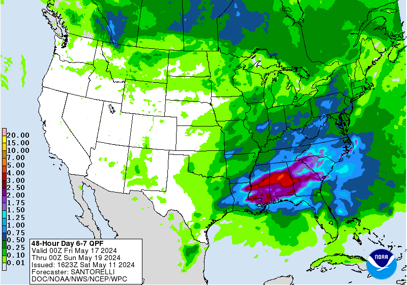
See the drought monitor below and the EXTREME drought in the TX panhandle, which grows alot of cotton. Days 6-7 rains fall exactly where they would benefit the most.............if the forecast verified.

Just too much rain for grains to rally. Rain makes grain in J-J-A and more rain, makes more grain.
Am surprised that grains are getting hammered this badly
CZ now down almost 50c from the highs 2+ weeks ago! SX down almost a whopping $1.20!
How much lower can we go?
18z GFS total rains for 2 weeks(which will be updated in the next hour, then 6 hours later)
Forecast Hour: 384
Image URL: http://mag.ncep.noaa.gov/data/gfs/18/namer/precip_ptot/gfs_namer_384_precip_ptot.gif

This last 0z, june 15th GSF just updated, no suprise...........tons of rain stil:
Forecast Hour: 372
Image URL: http://mag.ncep.noaa.gov/data/gfs/00/namer/precip_ptot/gfs_namer_372_precip_ptot.gif
