The hurricane season is usually June 1 to Dec 1. It's unusual to have a June hurricane. I will have to check to see if there has every been one effecting the US in May.
So its incredible that the GFS for numerous days in a rows develops a substantial hurricane later in May(after day 10) in the Caribbean and tracks it into the US.
Previous runs took it into the Gulf, then hits the Gulf Coast.
Latest run takes it into the far eastern GOM, then slams it into FL.
Maps that far out are not reliable but the persistence of this solution is getting my attention. Could be lending strength to the ng and oj markets right now.........which would be threatened(ng with shut ins) (oj with wind/rain damage)
HURRICANE before hitting FL, Then departing FL 48 hours later:
gfs_namer_300_200_wnd_ht | gfs_namer_300_500_vort_ht |
gfs_namer_300_1000_500_thick | gfs_namer_300_850_temp_ht |
gfs_namer_348_200_wnd_ht | gfs_namer_348_500_vort_ht |
gfs_namer_348_1000_500_thick | gfs_namer_348_850_temp_ht |
testing to see how the huge maps above effect the text in responses below
Latest on the GFS thinking there will be a hurricane after day 10. It's probably wrong. The 4 maps below are 4 days. Note the dates at the top of the maps:


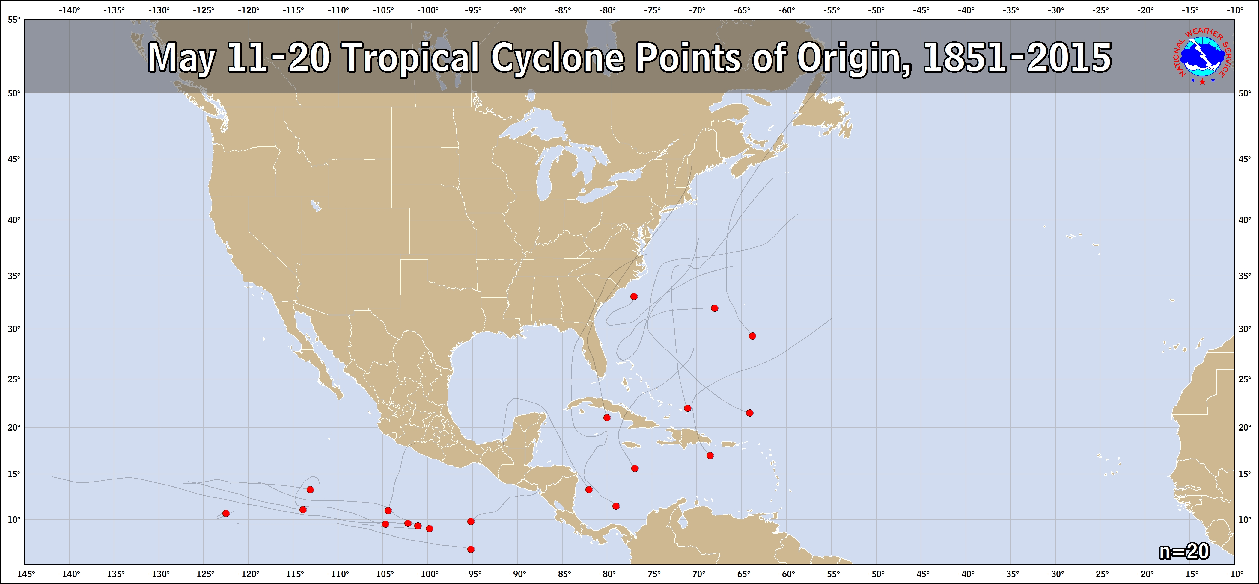
There have been only 4 TCs on record to form in the W Caribbean since 1851 during 5/11-20 (so about one every 40 years...so it is rare but not even close to impossible) as per this map with 2 of the 4 hitting FL:
https://www.nhc.noaa.gov/climo/images/may_11_20.png
The 4 were in 1970, 1933, 1916, and 1887 with 1970's Alma hitting FL as a TD and 1916 hitting FL as a minimal TS. This info tells me not to bet the farm against a W Caribbean genesis this mid May but certainly not to be on it happening. What I would bet a lot on is on there not being a H hit on the US from a potential mid May W Caribbean genesis. It is too early in the season to think of that as a reasonable possibility per this climo going back to 1851.
I also wouldn't bet much on a mid-May W Caribbean happening as the GFS in recent years has had cases where run after run for many days in a row had a W Caribbean genesis, especially during week 2, and nothing ended up forming. Also, I believe that the GFS is way too strong even if there were to be a genesis. Run after run has had a cat 2 H but there has been only 1 H form from a genesis there in mid May since 1851 and that was only a cat 1 for only 12 hours while still in the W Caribbean with a max of 80 mph! That was Alma of 1970:
http://weather.unisys.com/hurricane/atlantic/1970/ALMA/track.gif
Thanks Larry,
Let's continue this post vs the new one I started today when you were busy typing this comprehensive response.
YW, Mike.
Keep in mind how the GFS often way overstrengthened TCs last season. Example: remember those numerous Irma runs down below 900 mbs? Many of the runs turned out to have Irma 30+ mb too strong. This may be the reason the GFS is so ridiculously strong with this new potential. Could it be 30 mb too strong and we instead get something more like a 1000 mb TS instead of a cat 2 H when/if it gets to the US, if there's any TC at all? I say yes and climo backs this up.
Also, note that the Euro has nothing through its 10 days. That's quite telling. That increases the chance that this is a phantom despite the many GFS runs in a row having it and that, therefore, it shouldn't be bet on to happen even though there's a small chance it will.
I agree Larry but its amazing how persistent the GFS has been showing this at that time frame.
If nothing develops, then this is a serious model flaw. I would say, that conditions must be extremely favorable, especially for May to support this solution.
Mike,
The GFS has a serious flaw in being too aggressive with TCs, especially with geneses in the W Caribbean. It has literally had past instances of run after run of a W Caribbean genesis in week 2 with there ending up being literally nothing to develop! So, it wouldn't at all shock me if there ends up being no genesis even though I admit there's some chance for something to form down there after a week or so. Even the typically TC genesis happy Canadian has nothing there through day 10. That's quite telling as it is typically much worse than the GFS as far as phantom storms are concerned.
Thats very good to know Larry. Thanks!
This is after day 10 on the GFS of course, so the Canadian model thru day 10 does not cover the time frame.
However the Canadian ensembles go out 16 days and almost none of them have this. So your point is right on.
https://weather.gc.ca/ensemble/charts_e.html?Hour=312&Day=0&RunTime=00&Type=pnm
This thead is getting skinnier as we go down Larry and I'm concerned we will have to start it over soon........until we get this fixed.
Was reading over your earlier posts more, now that I have a bit of time and you convince me that the chance of this hurricane verifying is very, very small.
Its interesting to note that all the other prior May hurricanes happened BEFORE global warming/climate change.......1970 or earlier.
This is the complete opposite of what one position takes.........warmer oceans will cause stronger and earlier hurricanes to form
Last year featured some strong hurricanes that effected the Atlantic Basin(from a natural cycle) but there has been no definitive tendency in hurricane/typhoons over the past 2 decades.
What some do not know is that many of the strongest hurricanes and most active seasons have happened during global cooling(1954 along the East Coast) .
https://en.wikipedia.org/wiki/1954_Atlantic_hurricane_season
The meridional temperature gradient increasing during global cooling(colder at higher latitudes) causes a bigger temperature imbalance. The atmosphere has to work harder to expel heat from the tropics to balance this disparity. Hurricanes do that.
Good post, Mike. I noted a related thing a few days ago at Storm2K, a tropical wx BB. This is what I said:
"Well, supposedly a TC is there to bring up heat from the tropics to the higher latitudes. If the higher latitudes are warming more quickly, is there as much of a need for TCs to bring up heat to higher latitudes? I don't know. This is just food for thought."
Edit: Just to clarify, I was strictly talking about W Caribbean genesis during 5/11-20. There were 4 TCs on record since 1851 in that category and only one of those, Alma of 1970, was ever a H during its entire history and that was merely for 12 hours as a minimal cat 1 (and that was nowhere close to the US). I'm not talking about 5/1-10 and 5/21-31 genesis. Also, I'm not talking about May TC geneses outside of the W Caribbean. There have been several May storms that formed off the SE coast that made it to H strength.
A 5 star post Larry!
There the 12 z GFS goes again................only this time, the tropical system is several days later.
Yeah, I saw that, Mike. Whenever forecast time slips like that, it gives even greater credence to the idea that it is likely a phantom.
Agree Larry,
Your handle, WxFollower is a perfect fit.
The 18z GFS has no tropical system.
Following wx is easily my favorite hobby, Mike! There's almost never a dull moment.
Well, before we even will get a chance to know whether or not this GFS modeled storm, which is still on the runs but whose genesis is delayed somewhat, is a phantom, there already is something weak but wet in the SE Gulf that is headed north. It is highly doubtful that this ever becomes a strong storm but there is some chance for it to become a very early season subtropical or tropical depression and even a slight shot for it to make it to TS or STS status. Should it make it to TS or STS status, it would be the earliest on record for a Gulf TC or STC genesis. Regardless, its biggest impact should be heavy rainfall over FL and maybe other parts of the SE US this week as opposed to winds.
For the 1st time in several days, the latest GFS (12Z) has no TS+ form in or near the W Caribbean/Central America in its entire run. All it has is a weak low there that at most is a TD and it moves to near FL 5/27-9 as only a weak (1005 mb) low. The 0Z Euro does have a weak low in the NW Caribbean on day 10.