
Hello January 23rd! Share your blessings with somebody today. Seriously, don't just think about it for a moment......do it now.
http://www.weatherstreet.com/weather-forecast/Snow-Depth-US.htm
Latest snow cover map below:
Scroll down and enjoy the latest comprehensive weather to the max. More Winter weather is coming up!!!
Here are the latest hazards across the country. More cold and snow, lasting thru January in most places-Who will get the most snow? Looks even more like the pattern will warm up in February today!
Purple/Pink/blue on land is cold/Winter weather. Brown is wind, Green is flooding. Gray is fog. Reddish is a red flag advisory.
Go to the link below, then hit the location/county on the map for details.
https://www.spc.noaa.gov/ Go to "hazards"


Winter Weather
https://www.wpc.ncep.noaa.gov/wwd/winter_wx.shtml
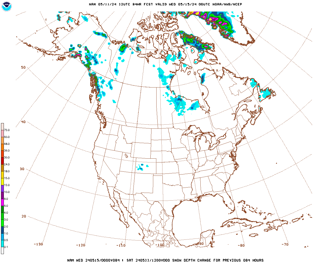
Snowfall the next 3 days:
Forecast Hour: 084
Image URL: http://mag.ncep.noaa.gov/data/nam/12/nam_namer_084_snodpth_chng.gif
| Low Temperatures Tomorrow Morning |

High Temperatures
Latest cold shot surging southeast!


Highs for days 3-7:
The cold blasts intensify, especially across the Midwest to Northeast.


How do these days 3-7 temperatures compared to average at this time of year?
Bitter cold heads south out of Canada in the N.Plains/Upper Midwest, where it will be brutally cold.........then pours east/southeast(and moderates a bit), increasing the blues..............and this is normally the coldest time of year, so this cold compares to the very cold averages.
https://www.wpc.ncep.noaa.gov/medr/medr_mean.shtml
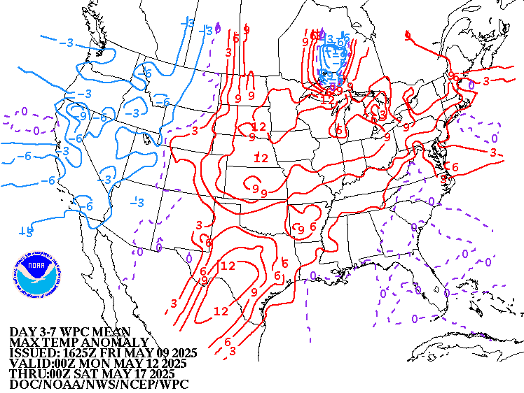
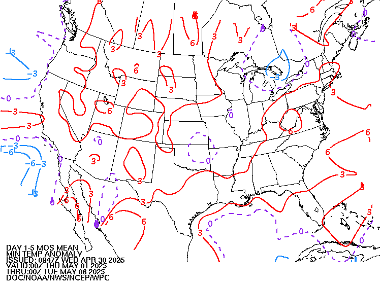
Weather maps for days 3-7 below:
Arctic blasts in the North, with reinforcements that takes them farther southeast......and some moderation.headed deeply south. Northern stream dominates but another storm(s) in the NorthEast. How much snow and where?

Liquid equivalent precip forecasts for the next 7 days are below.
Some of this will be heavy snow.
Day 1 below:
http://www.wpc.ncep.noaa.gov/qpf/fill_94qwbg.gif?1526306199054

Day 2 below:
http://www.wpc.ncep.noaa.gov/qpf/fill_98qwbg.gif?1528293750112

Day 3 below
http://www.wpc.ncep.noaa.gov/qpf/fill_99qwbg.gif?1528293842764

Days 4-5 below:
http://www.wpc.ncep.noaa.gov/qpf/95ep48iwbg_fill.gif?1526306162

Days 6-7 below:
http://www.wpc.ncep.noaa.gov/qpf/97ep48iwbg_fill.gif?1526306162

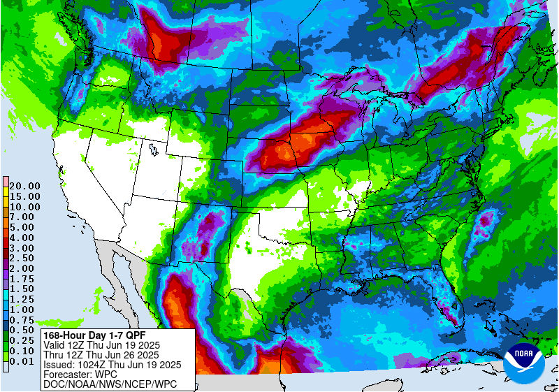
7 Day Total precipitation below:
http://www.wpc.ncep.noaa.govcdx /qpf/p168i.gif?1530796126
Current Dew Points
Moisture now returning in green.

Latest radar loop
http://www.nws.noaa.gov/radar_tab.php

| Full resolution version loop (3400x1700 pixels - 2.2mb) |

Go to: Most Recent Image
Precipitation the past 24 hours
![]()
You can go to this link to see precipitation totals from recent time periods:
https://water.weather.gov/precip/
Go to precipitation, then scroll down to pick a time frame. Hit states to get the borders to see locations better. Under products, you can hit "observed" or "Percent of normal"
+++++++++++++++++++++++++++++++++++++++++++++++
Soil moisture anomaly:
Still wet on this particular metric in an enormous area.

+++++++++++++++++++++++++++++++++++++
Precipitation compared to average for the last 7, 14, 30 and 60 days.
Usually not updated for previous day until late the next day.
https://www.atmos.illinois.edu/~snodgrss/Ag_Wx.html


The top map is the Canadian ensemble average, the maps below are the individual members that make up the average
+++++++++++++++++++++++++++++++++++++++++
Each member is like the parent, Canadian model operational model.......with a slight tweek/variation in parameters. Since we know the equations to represent the physics of the atmosphere in the models are not perfect, its useful to vary some of the equations that are uncertain(can make a difference) to see if it effects the outcome and how.
The average of all these variations(ensembles) often yields a better tool for forecasting. It's always more consistent. The individual operational model, like each individual ensemble member can vary greatly from run to run.........and represent an extreme end of the spectrum at times. The ensemble average of all the members, because it averages the extremes.............from opposite ends of the spectrum.........changes much less from run to run.
End of week 2....................0z ensembles from Wednesday:
Analysis starting from a week ago, ending with today:
Last Wednesday: most of the members still have the same solution, described Friday but an increase in those undercutting it with milder Pacific flow............in the upper levels. Again, at the surface, bitter cold air can still penetrate much farther south, however, we should watch to see what the upper level trend is.
Thursday: Solutions that show the polar vortex retreating continue to increase. It's still a cold pattern but not nearly as extremely cold for this product as recent days.
Friday: As mentioned the past 2 days, we have numerous solutions that show a retreat and filling of the polar vortex but still some very cold ones that look similar to majority from earlier this week. The average is still pretty cold.
Saturday: The ensemble average is continuing to show more undercutting flow (under the retreating polar vortex) and an increase in members that feature west to even southwest(in the southeast) steering winds in the upper levels. However, at the surface, bitter cold air in Canada is very dense and is hard to stop headed south, so it will likely make more progress than the upper level pattern suggests.............and there are still several pretty cold solutions in the upper levels.........just nothing like we saw a week ago for this end of week 2 period. The trend is getting less cold!
Saturday late morning update: The 12Z run was much colder again. This, because around half the members have decided that the polar vortex is going to take another dip south again. WIth the solidly negative AO, such cold changes are not a big surprise. When the AO is this negative, models tend to under forecast the amount of cold that get flushed south from high latitudes into the mid latitudes(US). Right now, we are having a battle between the Pacific flow trying to move in and the northern stream, which is being modulated by the position of the polar vortex.
Sunday: A bit more bullish with the cold west, like the 12z run yesterday but the ridge west/trough east couplet is retrograding/backing up a bit westward on the average. So the entry point of the cold may be farther west.
12z run continues this trend. This could lead to the East warming up and West cooling down in February and turn out bearish ng because more people live in the East............if that defines the new pattern(still great uncertainty)
Update: I take that back on the 12z Canadian run. That last statement is true of all the other models but the 12z Canadian model, on closer analysis is stronger and deeper south and east with the polar vortex and much colder in the Midwest/East in contrast to the other models and its own previous solutions.
Monday: 12z run: Milder solutions are gaining favor, colder ones losing out but still possible. Entry point of the cold looks farther west than it did on last weeks solutions. Yesterdays colder 12z model has been the exception to this trend the last 2 days.
Tuesday: 12z run: Though most of the recent solutions have been milder, more undercutting/Pacific flow and less northern stream, this last one is slightly colder again.
Wednesday: Same milder theme as previous solutions late in week 2, with the exception of yesterdays 12z run.
360h GZ 500 forecast valid on Feb 07, 2019 00 UTC
0Z GFS Ensembles at 2 weeks:
Analysis, starting with a week ago:
Last Tuesday: This was the coldest solution yet for this model, coming out just before midnight. WOW! It couldn't get any colder than this.
Wednesday: Clearly not nearly as cold...............as the extreme cold of previous days. Polar vortex retreats but this is still pretty dang cold. Cold does not penetrate deeply into the Southeast. It should be noted that the European model ensembles were still VERY cold at the end of 2 weeks and do not show any let up.
Thursday: Much colder than the Canadian model. Some pretty extreme solutions with polar vortex displaced very far south.
Friday: Still MUCH colder than the Canadian model and some very extremely cold solutions but a tad less cold. The rest of the guidance overnight was milder than the solution below, however.
Saturday: Marked milder change with almost half the solutions bringing mild Pacific flow across the country. Several, however still have the polar vortex a thing to be reconned with, displaced unusually far south.
Sunday: At the end of week 2 we have a battle between the pattern displayed over the past 10 days............large scale, full latitude ridge west/trough east couplet in North America with the polar vortex displaced unusually far south and an attempt for Pacific flow to undercut that northern stream dominate flow. The northern stream is still winning here.
Monday: The northern stream dominated solutions are steadily losing ground, although the cold on this model is still aimed towards the Northeast on several solutions.
Tuesday: The northern stream continues to be deflected out of the US picture by many members.................but still several that disagree.
Wednesday: More widespread agreement on milder as week 2 progresses.

Latest, updated graph/forecast for AO and NAO here, including an explanation of how to interpret them.
Previous analysis, with the latest day at the bottom for late week 2 period.
Last Monday: Very negative AO. NAO a bit more negative today. PNA slightly positive.
Tuesday: Same as yesterday. A couple of AO solutions bounce to zero, the rest are extremely low/cold.
Wedneday: AO not as extremely negative, less favorable for the extreme cold to continue.......but still quite negative on many solutions. NAO now closer to zero, less favorable for cold to drive deeply south into the US. PNA now closer to zero vs being positive.........less favorable for cold dropping south.
Thursday: AO spread is incredibly wide, from extremely negative to solidly positive. NAO spread fairly wide but slightly negative. PNA morphing towards zero, slightly less positive. Less likely for cold to continue into February but tremendous uncertainty.
Friday: AO spread is huge still. A few incredibly negative some around zero. NAO has increased from earlier this week to near zero. PNA also decreased to near zero...................so less favorable for cold but still favorable.
Saturday: AO has a bit less spread but is gyrating around in solidly negative territory, which strongly favors cold.....though some extended models want to warm things up. NAO is around zero with enough spread for uncertainty. PNA is dropping steadily and is becoming less favorable for cold and supports milder Pacific air masses coming in to replace Arctic air masses by late week 2.
Sunday; Some noteworthy changes. The AO is still solidly negative but with extreme spread.......good for cold to move from high latitudes to mid latitudes. The PNA is slowly dropping to slightly negative after being positive forever and the NAO is slightly positive. This suggests the potential for the cold to have an entry point farther west? Or for a pattern change that features colder west and warmer east. Less ridging west/more troughing west, less troughing/more ridging east.
Monday: AO continues solidly negative, good for cold air movement south. NAO around zero is neutral. PNA has continued to drop and is more negative again today. More negative than its been in a long time in fact. This suggests a potential pattern change with less ridging west to more troughing there. This would change the jet stream in the US and could deflect the northern stream back towards Canada in the East.
Tuesday: Similar to yesterday. AO solidly negative, good for cold air moving south but the NAO is slighly positive and PNA is a bit negative which will make it tougher for cold to get into the US.
Wednesday: AO less negative. NAO more positive, PNA more negative. All make a case for the February forecast to be morphing milder.
The link below, now has the PNA index added at the bottom:
National Weather Service 6-10 day, 8-14 day outlooks.
Updated early this afternoon:
The cold pattern will be well established during this period..............with some big snows adding to it in the northern half of the country. Temps will be even colder over deep snow packs.
Now we just try to figure out how cold and how long it will last. Latest guidance has been going back and forth on this.
Latest guidance is ending the coldest weather during the first week of February. This continues on Wednesday.
Temperature Probability | |
Precipitation Probability | |
| the 8-14 day outlooks ArchivesAnalogsLines-Only FormatGIS Data | |
Temperature Probability | |
 | |