It's October 15th! Don't let another day fly by. Do something special for somebody to remember today! Seriously, don't just think about it for a moment......do it.
Scroll down and enjoy the latest comprehensive weather to the max!!
The latest frost and freezing advisories across the country are below:
The latest rain forecasts for the next week are below. Advertised pattern change is here. Upcoming week will feature, widespread dry weather for the Cornbelt.
Day 1 below:
http://www.wpc.ncep.noaa.gov/qpf/fill_94qwbg.gif?1526306199054

Day 2 below:
http://www.wpc.ncep.noaa.gov/qpf/fill_98qwbg.gif?1528293750112

Day 3 below:
http://www.wpc.ncep.noaa.gov/qpf/fill_99qwbg.gif?1528293842764

Days 4-5 below:
http://www.wpc.ncep.noaa.gov/qpf/95ep48iwbg_fill.gif?1526306162

Days 6-7 below:
http://www.wpc.ncep.noaa.gov/qpf/97ep48iwbg_fill.gif?1526306162

7 Day Total precipitation below:
http://www.wpc.ncep.noaa.govcdx /qpf/p168i.gif?1530796126

Excessive Rain threat
Mostly Texas......but also points just northeast.
Current Day 1 Forecast
Day 1 Threat Area in Text Format
Current Day 2 Forecast |
Day 3 forecast below

Here are the latest hazards across the country. The dark purple is a freeze warning. The bright purple is a hard freeze warning. The light/bright blue is a freeze watch, darker/medium blue is a frost advisory.
Green is a flash flood watch.
https://www.spc.noaa.gov/ Go to "hazards"

High Temperatures today and Tuesday.
Temperatures continue over 30 deg. F cooler in many places compared to last week!!! Very warm in the Southeast.


Highs for days 3-7:
The very chilly air will feature temperatures remaining 30+ degrees colder than recent days.............but the coldest air is aimed farther east, towards the Midwest and especially the Northeast(where lots of people live and need heating) vs before, when the cold was aimed at the N.Plains.


How do these days 3-7 temperatures compare to average at this time of year?
Magnitude of cold anomalies shrinks compared to before and location shifts east.

Low Temperature Departures:

Surface features for the same 3-7 day period:
Chilly Canadian high pressure in charge. Reinforcing cold fronts next week with slight moderation in between. Mostly dry weather as the atmosphere will be dried out. Cold is directed farther east compared to last week.

Current Dew Points
Extraordinarily dry air in the Plains to Midwest! First freezes and frosts of the season happening.

Latest radar loop.
http://www.nws.noaa.gov/radar_tab.php

Rains the past 24 hours
![]()
You can go to this link to see rain totals from recent time periods:
https://water.weather.gov/precip/
Go to precipitation, then scroll down to pick a time frame. Hit states to get the borders to see locations better. Under products, you can hit "observed" or "Percent of normal"
The rains below probably did some damage:
6-day rainfall totals through 7 AM CDT on October 10, centered on the Kansas City area An area that could not buy a rain all summer gets 6-12" in a six-day time frame...in October
Soil moisture anomaly:
Much too wet in a large area. Drying has commenced in all of the Midwest!!!

Rains compared to average for the last 7, 14, 30 and 60 days.
Usually not updated for previous day until late the next day.
Note how incredibly wet it's been over the past 60 days over eastern 2/3rds of the country!
https://www.atmos.illinois.edu/~snodgrss/Ag_Wx.html


The top map is the Canadian ensemble average, the maps below are the individual members that make up the average
End of week 2....................0Z ensembles from Monday. Big change since the weekend, especially for an ensemble average. Less zonal and much deeper trough in the Midsection to East.......which will tug down cold air from Canada with some gusto. Upper level ridging to the west!
Mostly Dry pattern.
++++++++++++++++++++++++++++++++++++++++++++++++++++++++++++++
Each member is like the parent, Canadian model operational model.......with a slight tweek/variation in parameters. Since we know the equations to represent the physics of the atmosphere in the models are not perfect, its useful to vary some of the equations that are uncertain(can make a difference) to see if it effects the outcome and how.
The average of all these variations(ensembles) often yields a better tool for forecasting. It's always more consistent. The individual operational model, like each individual ensemble member can vary greatly from run to run.........and represent an extreme end of the spectrum at times. The ensemble average of all the members, because it averages the extremes.............from opposite ends of the spectrum............changes much less from run to run.
360h GZ 500 forecast valid on Oct 30, 2018 00 UTC


The low skill, longer range CFS model for weeks 3-4.
Strong Upper level ridge in Alaska/NW Canada/West Coast........... upper level trough downstream and very chilly temperatures for the eastern 1/2 of the USA. This is bullish natural gas as it suggests cold into early November!
Not as dry as before.
Heating degree days(from cold weather) have replaced cooling degree days(from hot weather) at this time of year.
Check in tomorrow to read something different............."low skill" (-:

Precip below:

NWS 6-10 day and 8-14 day forecasts:
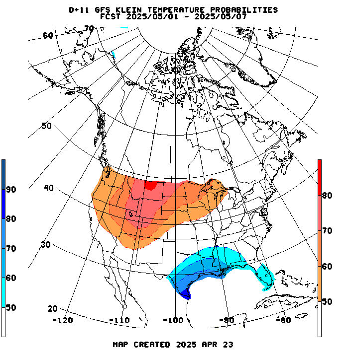
Dry pattern. Warm West, chilly East. Expected to be similar this afternoon, with the cold anomalies in the East/Southeast increasing compared to recent weather.
Temperature Probability | |
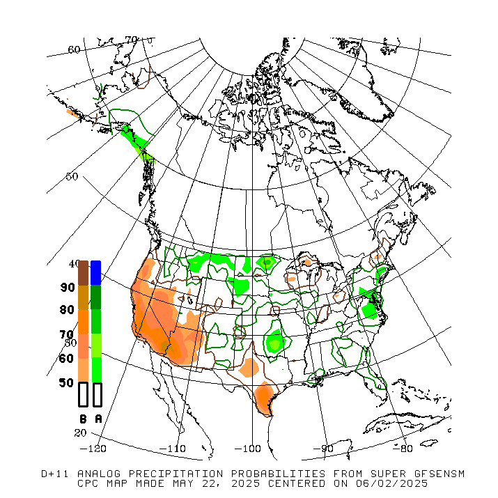
Precipitation Probability | |

8 to 14 day forecast below: | |
Temperature Probability | |
Updated guidance tools for 8-14 day later today:
Extreme weather days 3-7:
Cold Northeast, wet in Texas.

Extreme weather days 8-14
Wet along the Gulf Coast back to TX.
