Since I grew up in Detroit MI and spent a great deal of Summer time on Lakes Huron and Michigan but also Lake Superior and Lake St. Claire, this one has more meaning.
NOAA - Great Lakes Environmental Research Laboratory
https://www.glerl.noaa.gov/data/ice/glicd.php


+++++++++++++++++++++
![]()
https://coastwatch.glerl.noaa.gov/statistics/great-lakes-ice-concentration/
https://apps.glerl.noaa.gov/coastwatch/webdata/statistic/ice/dat/g2025_2026_ice.dat
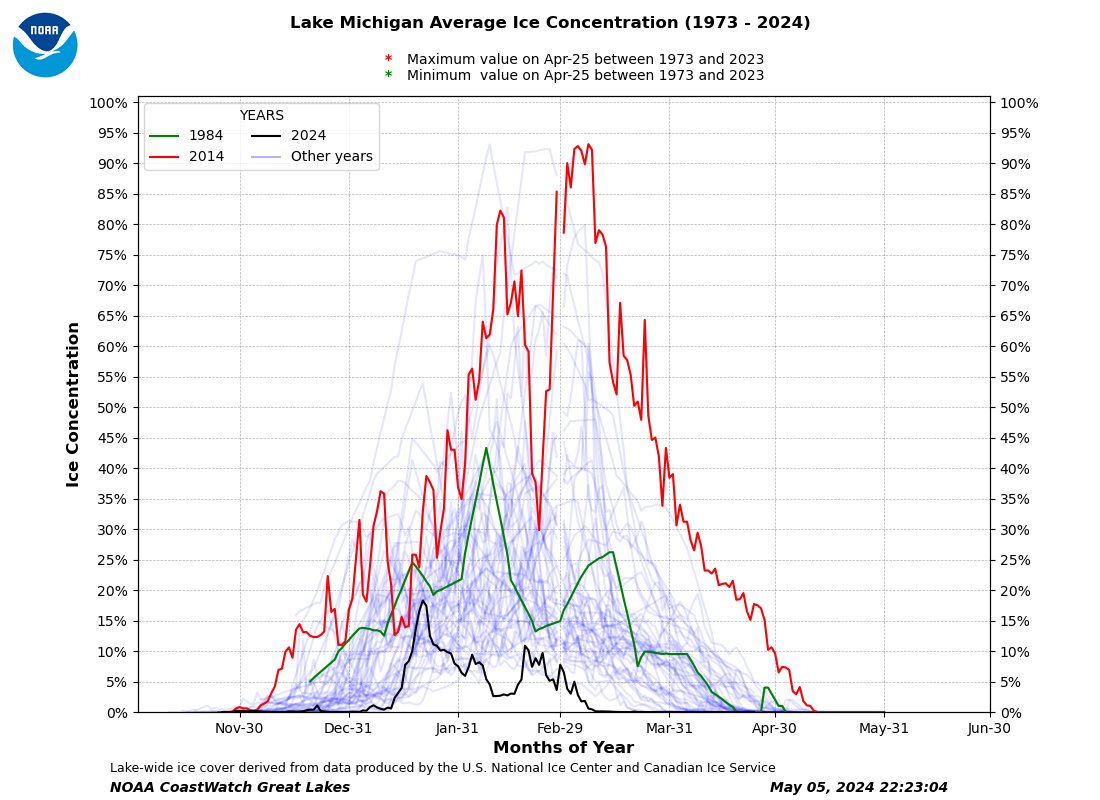
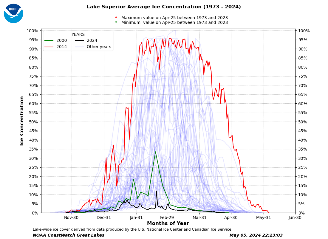
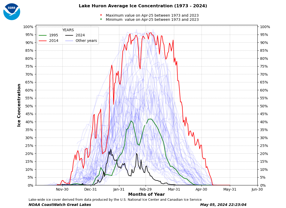
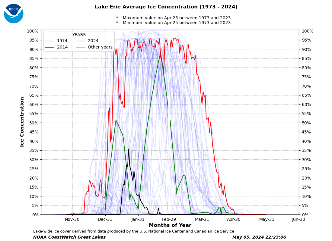
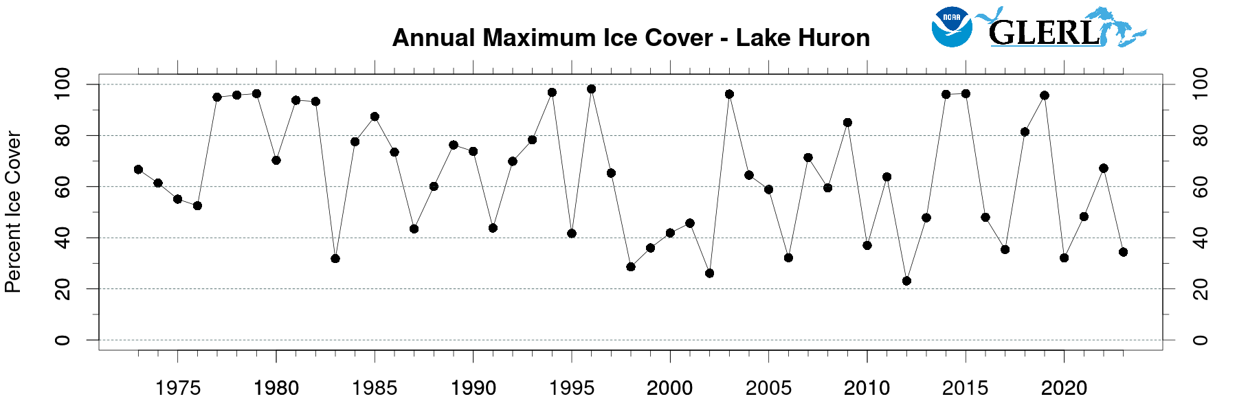
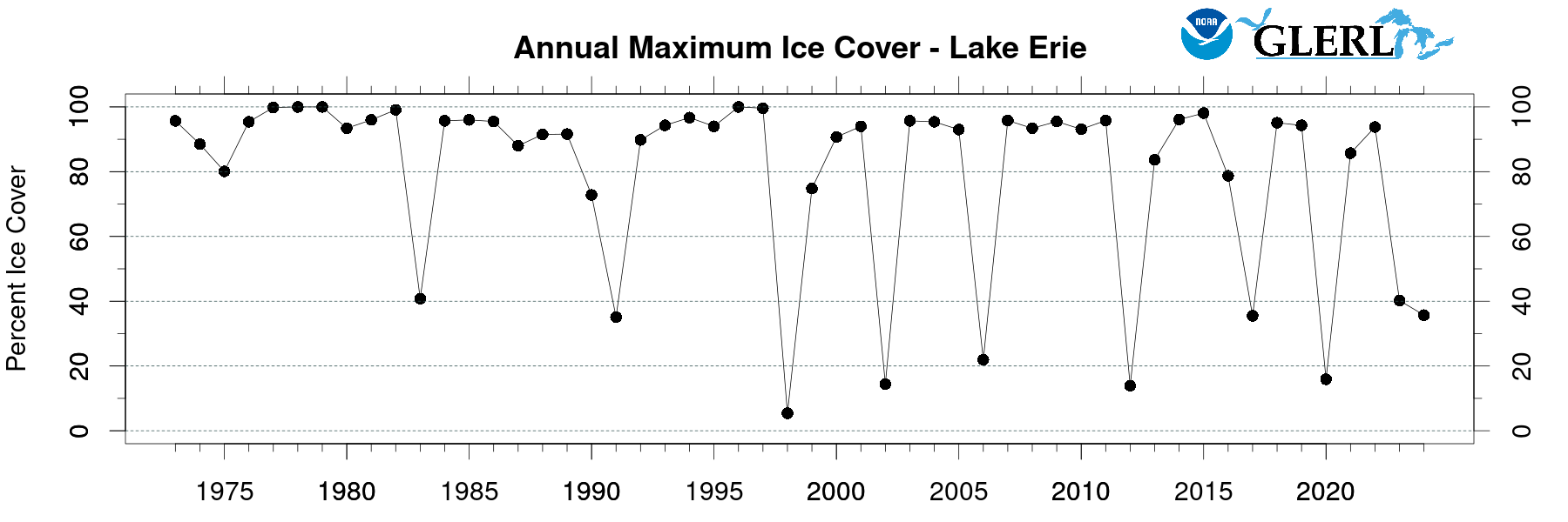
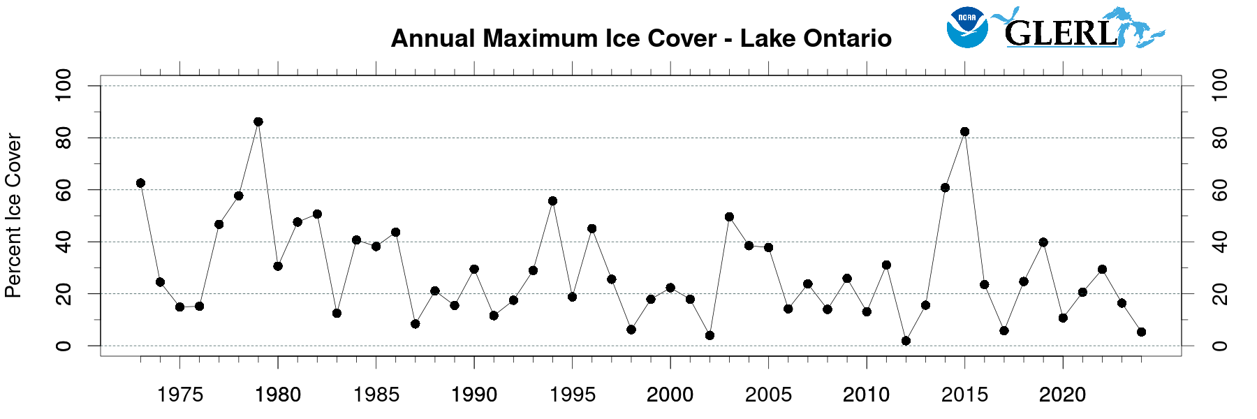
This data only started in 1973 because that was when we first had satellites able to accurately measure it!
https://apps.glerl.noaa.gov/coastwatch/webdata/statistic/ice/png/all_year_ice_m.png
https://apps.glerl.noaa.gov/coastwatch/webdata/statistic/ice/png/all_year_ice_s.png
https://apps.glerl.noaa.gov/coastwatch/webdata/statistic/ice/png/all_year_ice_h.png
https://apps.glerl.noaa.gov/coastwatch/webdata/statistic/ice/png/all_year_ice_o.png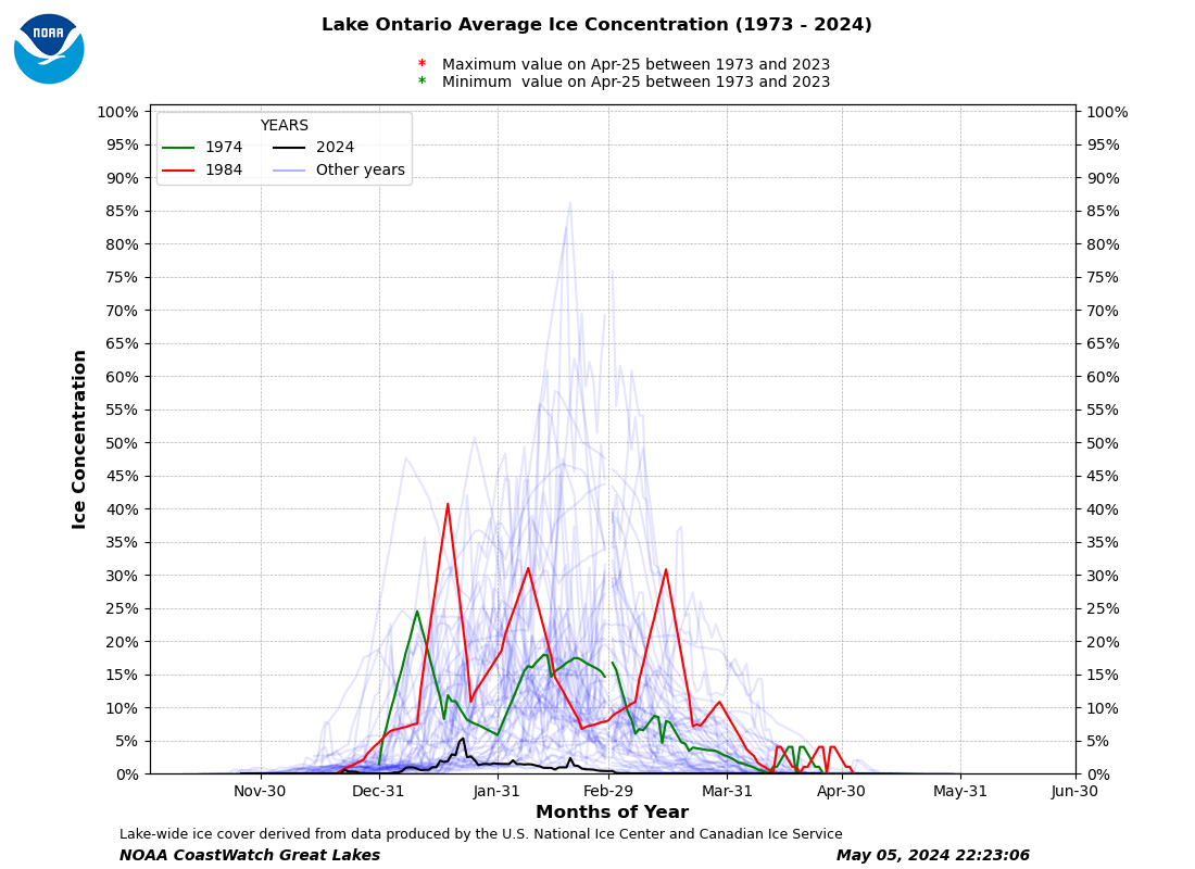
https://apps.glerl.noaa.gov/coastwatch/webdata/statistic/ice/png/all_year_ice_e.png
https://www.instagram.com/reel/DT78xCQEbW_/
++++++++++++
After a deep freeze across the Great Lakes region, Lake Erie is nearly completed iced over and the rest of the lakes have seen significant increases in coverage.
Researchers on Sunday, Jan. 25, reported the Great Lakes were 43.18% frozen over — about an 18 percentage point increase from last week. The jump coincides with a surge of Arctic air that moved in Thursday, Jan. 22, according to the National Oceanic and Atmospheric Administration's Great Lakes Environmental Research Laboratory.
Lake Erie was nearly frozen over at 92% coverage. Ice ranged from 2-12 inches, with the thickest along shoreline. Lake Huron was 51.61% covered, researchers said.
The thickest ice has formed along Lake Superior's shorelines — 12-28 inches in places — with lakes Erie, Michigan and Huron reporting thickness from less than 2 inches up to 12 inches.
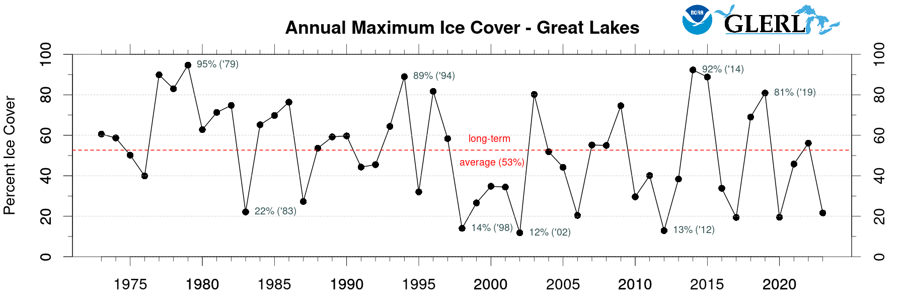
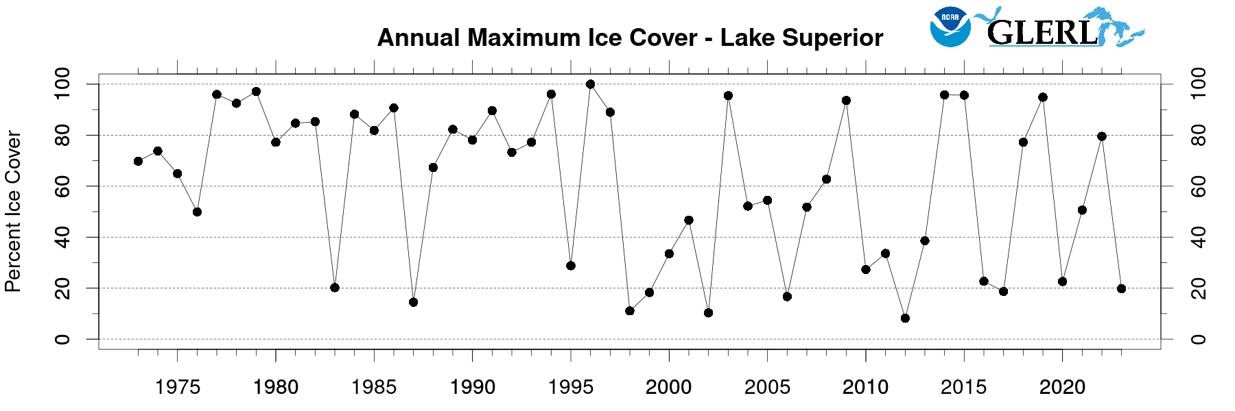
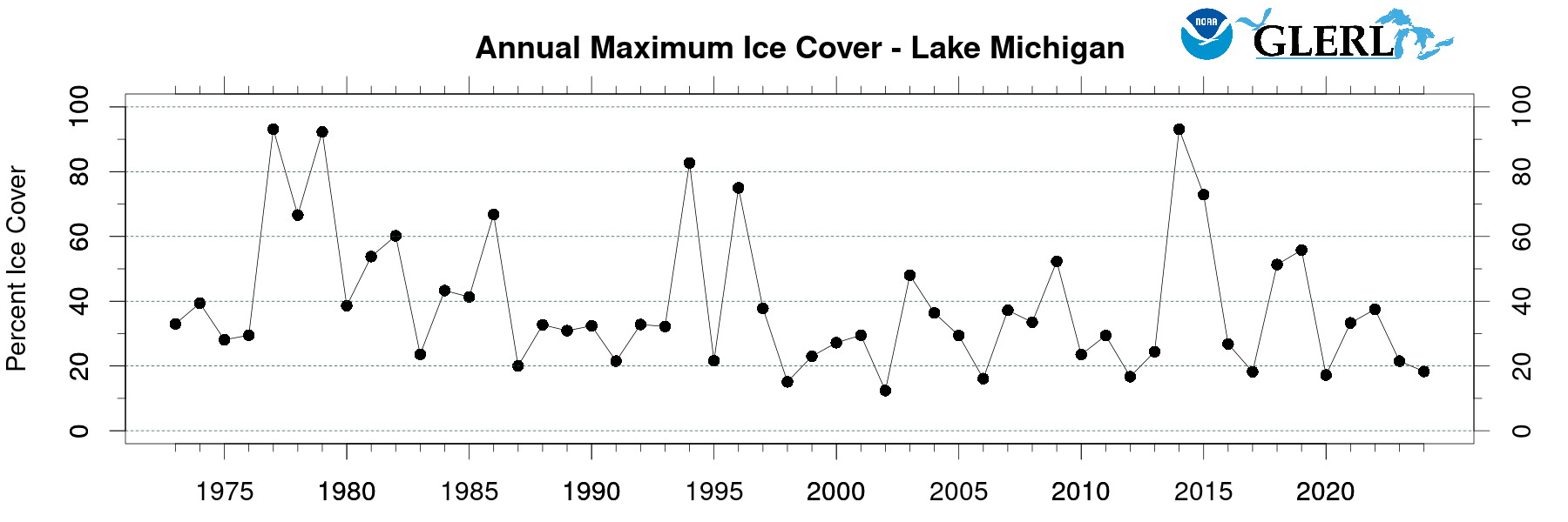
Here's another way to look at the PAST data:
NOAA - Great Lakes Environmental Research Laboratory
https://www.glerl.noaa.gov/data/ice/#historical
https://glisa.umich.edu/resources-tools/climate-impacts/lake-effect-snow-in-the-great-lakes-region/
Summary
During the late fall and winter seasons in the Great Lakes region, the flow of cold air masses across the relatively warm waters of the Great Lakes waters results in the production of dramatic lake-effect snowfall downwind of the lakes, particularly on the southern and eastern shores. This lake-effect produces increased seasonal snowfall amounts compared with communities farther inland, as well as located upwind of the Great Lakes.

Lake-effect snow over the Great Lakes.
The Upper Peninsula Snowbelt
The Upper Peninsula of Michigan features one of the largest and most distinct snowbelts in the United States. Due to their large area and depth, the surface waters of Lake Superior, Lake Michigan, and Lake Huron freeze less completely. With open lake water throughout the winter months, lake-effect snow can fall continually across the Upper Peninsula and Canadian snowbelts. From the Porcupine Mountains and the Keweenaw Peninsula to Whitefish Point, snowfall is dramatically enhanced by lake effects. In some areas, annual snowfall totals commonly exceed 250 inches (635 cm) per year. The Keweenaw Peninsula, which averages more snowfall than any location in the United States east of the Mississippi River, owes much of its winter snowfall to lake effects. For comparison, Duluth, Minnesota, which lies outside the lake effect zone at the southwestern tip of Lake Superior, receives 78 inches (198 cm) per season.

Lake-effect snow over Lake Superior.
Lake Michigan Snowbelt
Western Michigan, Northwestern Lower Michigan, and Northern Indiana can experience heavy lake-effect snow. As winds pass over Lake Michigan and generate snow, areas near Traverse City (MI), Muskegon (MI), Grand Rapids (MI), Kalamazoo (MI), South Bend (IN), and Elkhart (IN) can experience significant, often disruptive, lake-effect snowstorms. These snowfall events can reach far across Michigan and Indiana, but typically result in reduced snowfall totals before reaching areas such as Lansing (MI) and Fort Wayne (IN). When these cold winds flow across the short axis of a given lake (e.g., west to east across Lake Michigan), multiple effects of bands are predominant. In contrast, when these cold winds flow along the long axis of a given lake (e.g., north to south across Lake Michigan), a single band of lake-effect snow is often produced. Under cold northerly flow down the length of Lake Michigan, intense, but localized, lake-effect snowfall can be observed in Northwestern Indiana.

Approximate extent of major lake-effect snowbelts in the Great Lakes region. Image provided by the City University of New York (CUNY) Hunter College Dept. of Geography.
Lake Huron Snowbelt
Much of Southern Ontario to the east of Lake Huron can experience intense lake-effect snowfall and notorious whiteout conditions. The greatest accumulations typically occur on the Bruce Peninsula, which divides the main body of Lake Huron from the Georgian Bay to the east. Bounded by the lake on all sides except to the south, the Bruce Peninsula experiences lake-effect precipitation during most winter weather events, except when the wind is directly from the south or when Lake Huron is significantly frozen over.
Lake Ontario and Lake Erie Snowbelts
The region east and southeast of Lake Ontario frequently sees daily snowfall totals that are higher than anywhere in the United States. Syracuse, New York, receives significant lake-effect snow from Lake Ontario, averaging 116 inches (294 cm) of snow per year. Lake Erie produces a lake effect zone stretching from the eastern suburbs of Cleveland, Ohio to Buffalo, New York. Due to its relatively shallow depths, Lake Erie has the distinction of being the only Great Lake capable of completely freezing over. As it freezes throughout the winter, and the supply of moisture from the lake surface is cut off, lake-effect snow events cease.
Climate Change and Snowfall
Overall, snowfall has increased in northern lake-effect zones in the Great Lakes basin even as snowfall totals in Illinois, Indiana, and Ohio have declined with rising temperatures. Warmer Great Lakes surface water temperatures and declining Great Lakes ice cover have likely driven the observed increases in lake-effect snow. As global temperatures continue to rise and further warm the Great Lakes, areas in lake-effect zones will continue to see increasing lake-effect snowfall. 1 Areas in more southern lake-effect zones may see lake-effect snow replaced by lake-effect rain, as winter temperatures will warm and be less suitable for snow.

https://www.reddit.com/r/MapPorn/comments/5oi8ql/map_showing_the_depths_of_the_great_lakes_3300_x/
https://www.visualcapitalist.com/visualized-the-depth-of-the-great-lakes/
did you know that altogether the Great Lakes contain 21% of the world’s surface freshwater by volume—or 84% of the surface freshwater in North America?
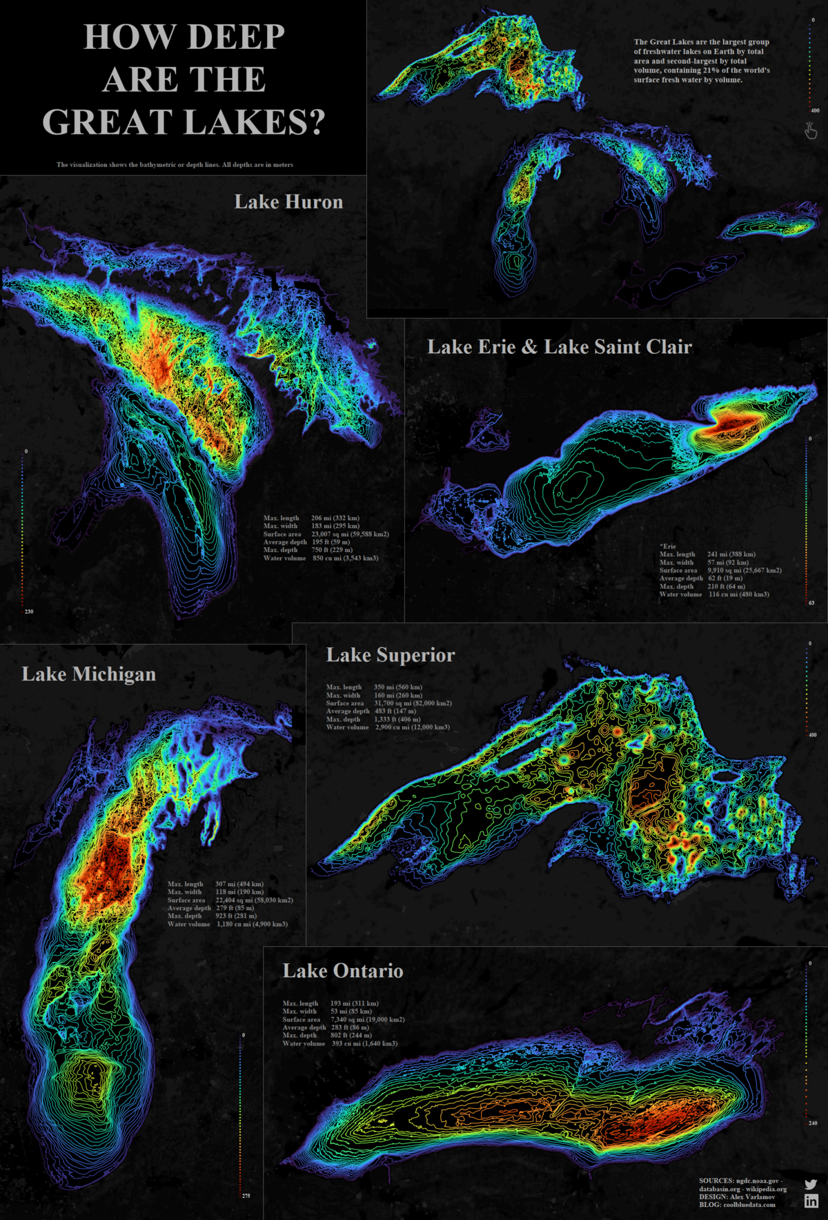
| Surface area | Water volume | Average depth | Maximum depth | |
|---|---|---|---|---|
| Lake Ontario | 19,000 km² (7,340 mi²) | 1,640 km³ (393 mi³) | 86 m (283 ft) | 245 m (804 ft) |
| Lake Erie | 25,700 km² (9,910 mi²) | 480 km³ (116 mi³) | 19 m (62 ft) | 64 m (210 ft) |
| Lake Michigan | 58,000 km² (22,300 mi²) | 4,900 km³ (1,180 mi³) | 85 m (279 ft) | 282 m (925 ft) |
| Lake Huron | 60,000 km² (23,000 mi²) | 3,500 km³ (850 mi³) | 59 m (195 ft) | 228 m (748 ft) |
| Lake Superior | 82,000 km² (31,700 mi²) | 12,000 km³ (2,900 mi³) | 147 m (483 ft) | 406 m (1,333 ft) |
Lake Erie is by far the shallowest of the lakes, with an average depth of just 19 meters (62 ft). That means on average, Lake Superior is about eight times deeper.
+++++++++++++
https://www.visualcapitalist.com/worlds-25-largest-lakes/
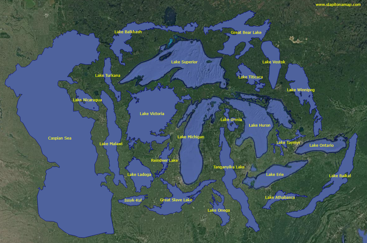
The largest lake in the world by a long shot is the Caspian Sea – a name that hints at a past when it was contiguous with the ocean around 11 million years ago. This massive saline lake, which is nearly the same size as Japan, borders five countries: Kazakhstan, Russia, Turkmenistan, Azerbaijan, and Iran. An estimated 48 billion barrels of oil lay beneath the surface of the basin.
The five Great Lakes, which run along the Canada–U.S. border, form one of the largest collections of fresh water on Earth. This interconnected series of lakes represents around 20% of the world’s fresh water and the region supports over 100 million people, roughly equal to one-third of the Canada–U.S. population.
Amazingly, a single lake holds as much fresh water as all the Great Lakes combined – Lake Baikal. This rift lake in Siberia has a maximum depth of 5,371ft (1,637m). For comparison, the largest of the Great Lakes (Lake Superior) is only 25% as deep, with a maximum depth of 1,333ft (406m). Lake Baikal is unique in a number of other ways too. It is the world’s oldest, coldest lake, and around 80% of its animal species are endemic (not found anywhere else).
Large Lakes of the World
https://seagrant.sunysb.edu/Images/Uploads/PDFs/IAGLR-LargeLakesOfTheWorld0512.pdf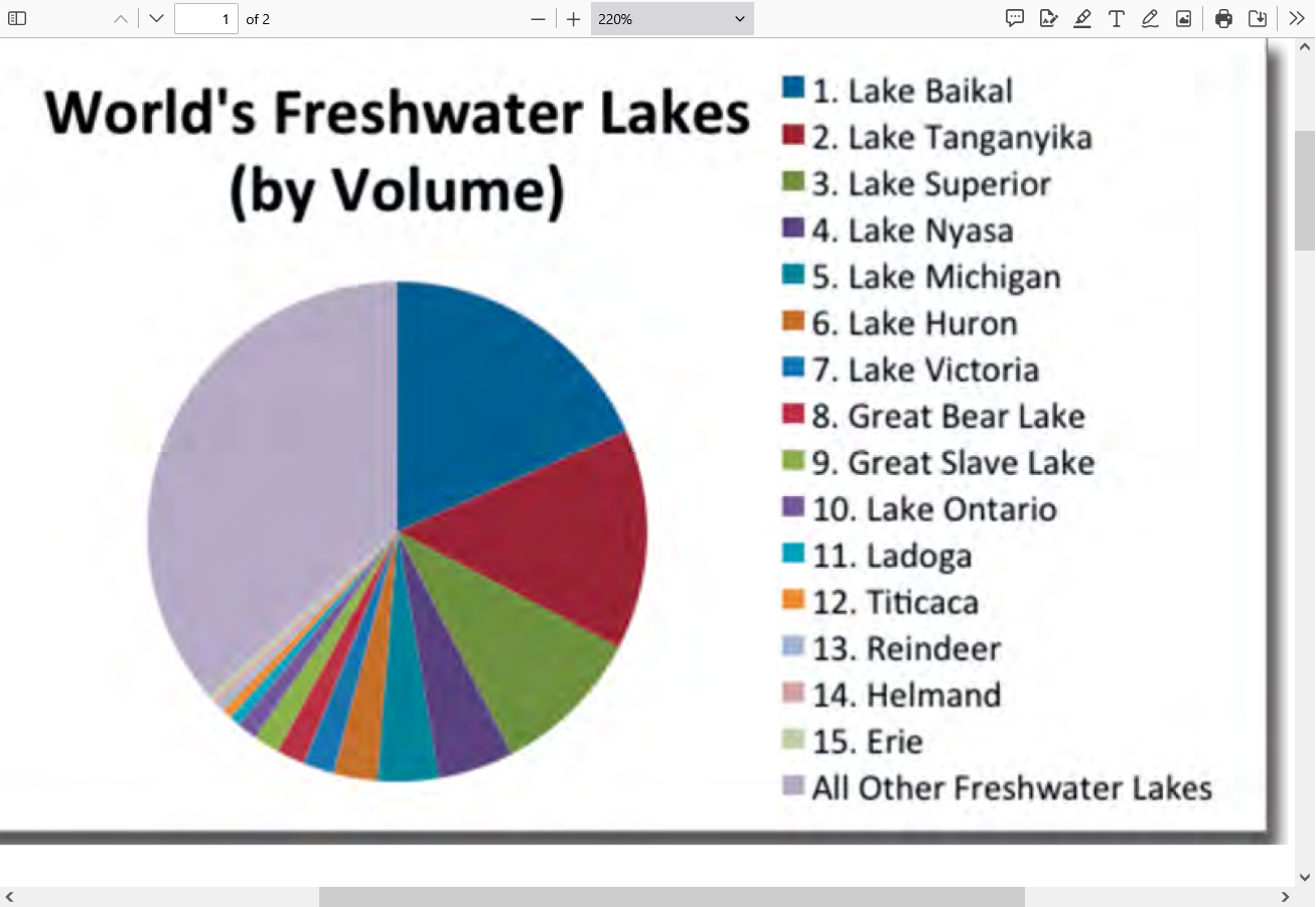
5 of the worlds biggest freshwater lakes are Great Lakes!
We live on a blue planet – yet only about 2.5% of the Earth’s water
is liquid freshwater. Liquid fresh surface water (lakes and rivers)
accounts for just 0.008% of the Earth’s water, yet it is this fraction that
supports most of human life and activity. The freshwater lakes of the
world are estimated to hold 125,000 cubic kilometers of water. Over
half of this volume is locked in just 5 lakes.
North America’s Great Lakes are represented in the 15 largest lakes
of the world. From Lake Superior (#3) to shallow Lake Erie (#15), the
Laurentian Great Lakes comprise 20% of the world’s fresh water.