Latest update here the first week in September:
The atmosphere is already in a weak La Nina mode. The official La Nina is a lagging indicator.
By metmike - Sept. 3, 2025, 3:48 p.m.
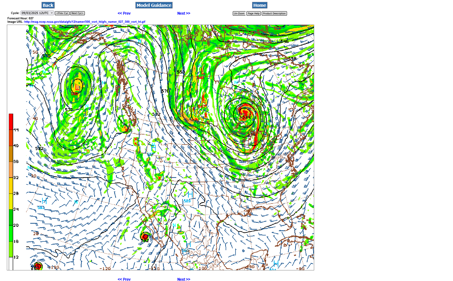
The map below is from the last 12z GFS operational model at 500 mb (18,00 feet) for Thursday morning. That deep low just north of Lake Superior is a huge piece of THE POLAR VORTEX!
We can see a huge kink in the lines, along the ND border with Canada from a strong perturbation/reinforcing wave with the colors representing powerful, positive vorticity(spin) associated with it. It's a strong reinforcement of this very chilly air that is rotating around the backside of the main/parent Low just north of Lake Superior.
This is more like a Winter pattern.
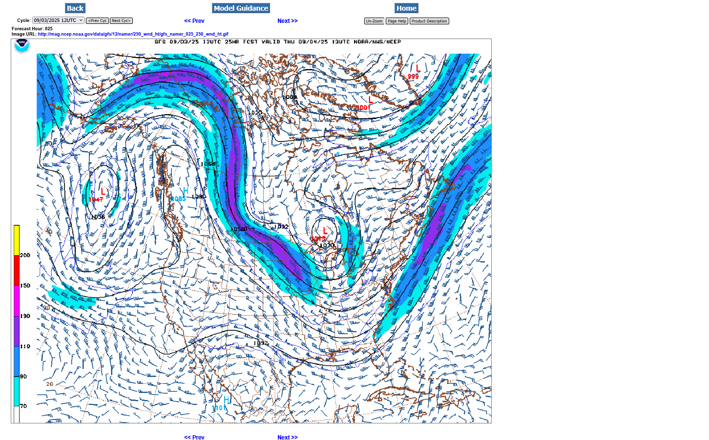
Here's the 250 jet stream(33,000 feet). Note it diving straight south/southeast, transporting air from much higher latitudes/the Arctic to the mid latitudes. The small pink color embedded within the jet stream represents a 150 mph jet streak!!
The piece of polar vortex at this level is also seen just north of Lake Superior.
A jet stream like this in 3+ months means brutally cold temps and a major Winter storm east of the trough line and/or associated with the lift from the jet stream dynamics. We can make out that kink in the isoheights that is northwest of the 500mb level, now much higher up, around the Alberta/ Saskatchewan border in Canada!
++++++++++++
Global temperatures August 2025
Started by metmike - Sept. 3, 2025, 7:34 p.m.
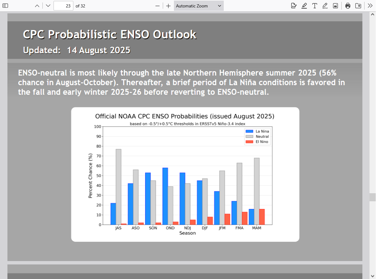
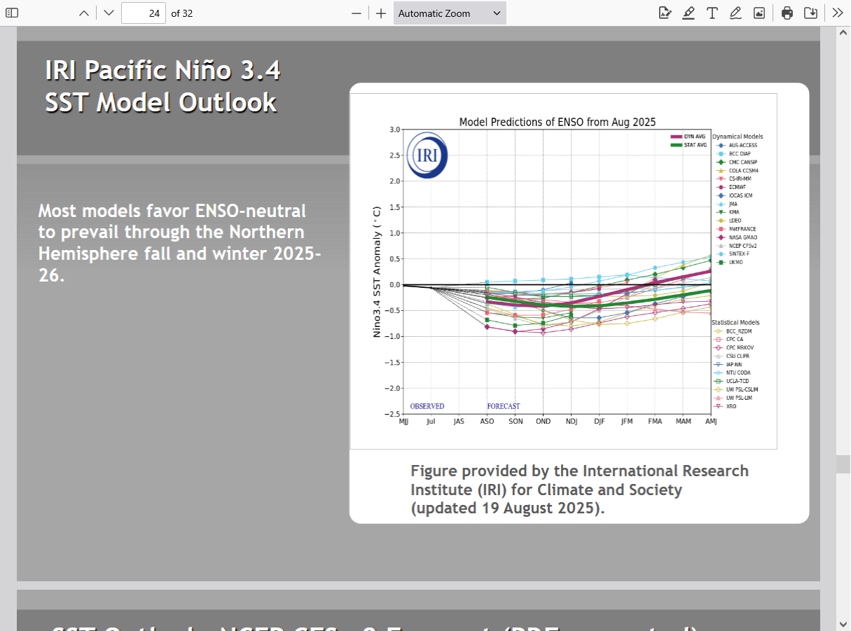
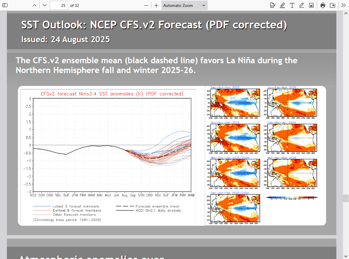
I'm betting this is WRONG because it doesn't fully show the La Nina signature but nobody gets long range forecasts right most of the time.
When we have a STRONG El Nino or STRONG La Nina, it does in fact increase forecast skill a great deal. This La Nina will be WEAK.
Here's the last NWS Winter forecast. MUCH different than above because they use the La Nina for much of their reasoning!
https://www.cpc.ncep.noaa.gov/products/predictions/long_range/seasonal.php?lead=4
: USDA September 12, 2025/Grains
By metmike - Sept. 18, 2025, 12:34 a.m.
Eric was in on Wednesday for his wonderful analysis:
https://www.youtube.com/watch?v=bxdmIK5oJE8
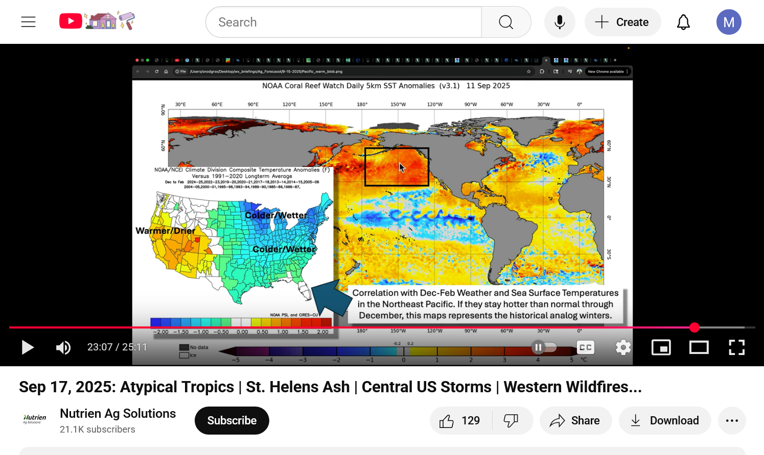
https://www.youtube.com/watch?v=hRYSdYFyMrw
+++++++++++++++++++
Ryan is EXTREMELY BULLISH for wicked cold and major snow storms in the northern half of the country. His forecast reasoning is very solid! Great video. He likes to embellish a bit but that makes it much more entertaining and he's the best at tying that together with providing entertaining, useful(life saving at times) and scientifically legit information.
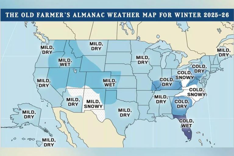
NOAA Releases 2025 – 2026 Winter Weather Prediction
https://unofficialnetworks.com/2025/09/22/noaa-winter-weather-forecast-september/
+++++++++++
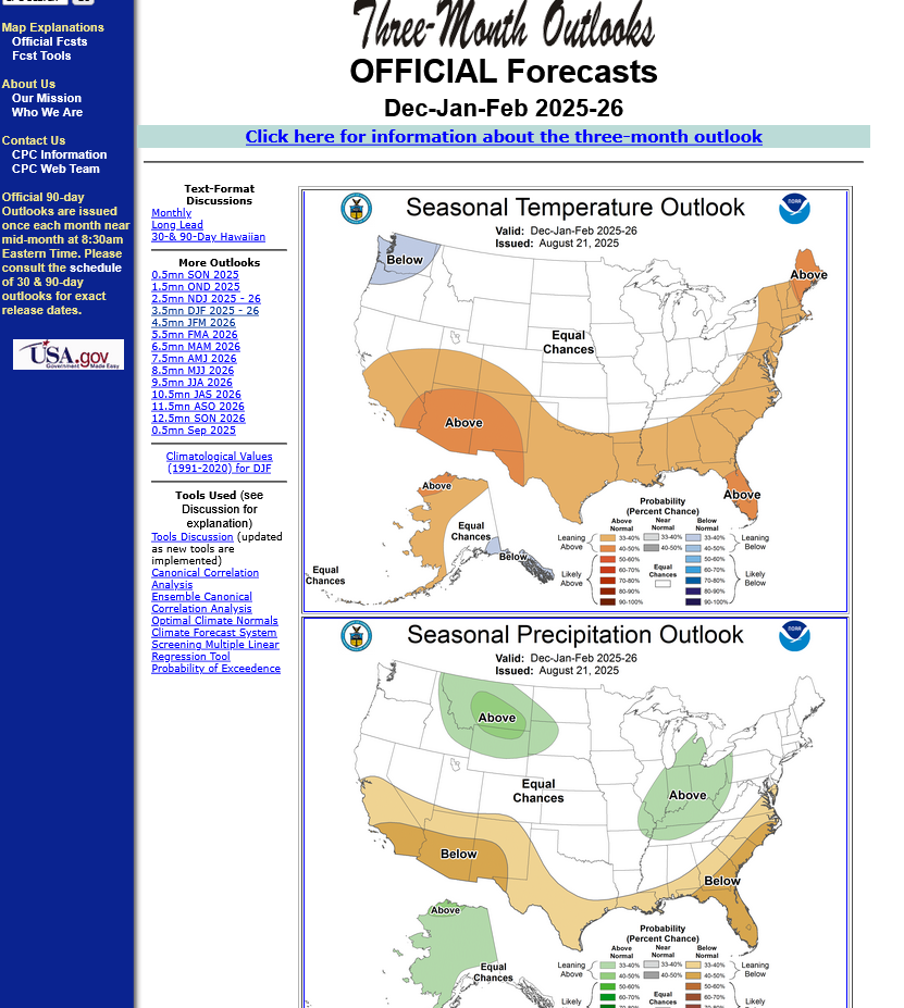
Here's the NWS link for all the long range forecasts. This article uses Jan-Mar for Winter but METEOROLOGICAL Winter is actually DEC-FEB, so we'll use that instead.
https://www.cpc.ncep.noaa.gov/products/predictions/long_range/
This is consistent with Ryan's forecast above.
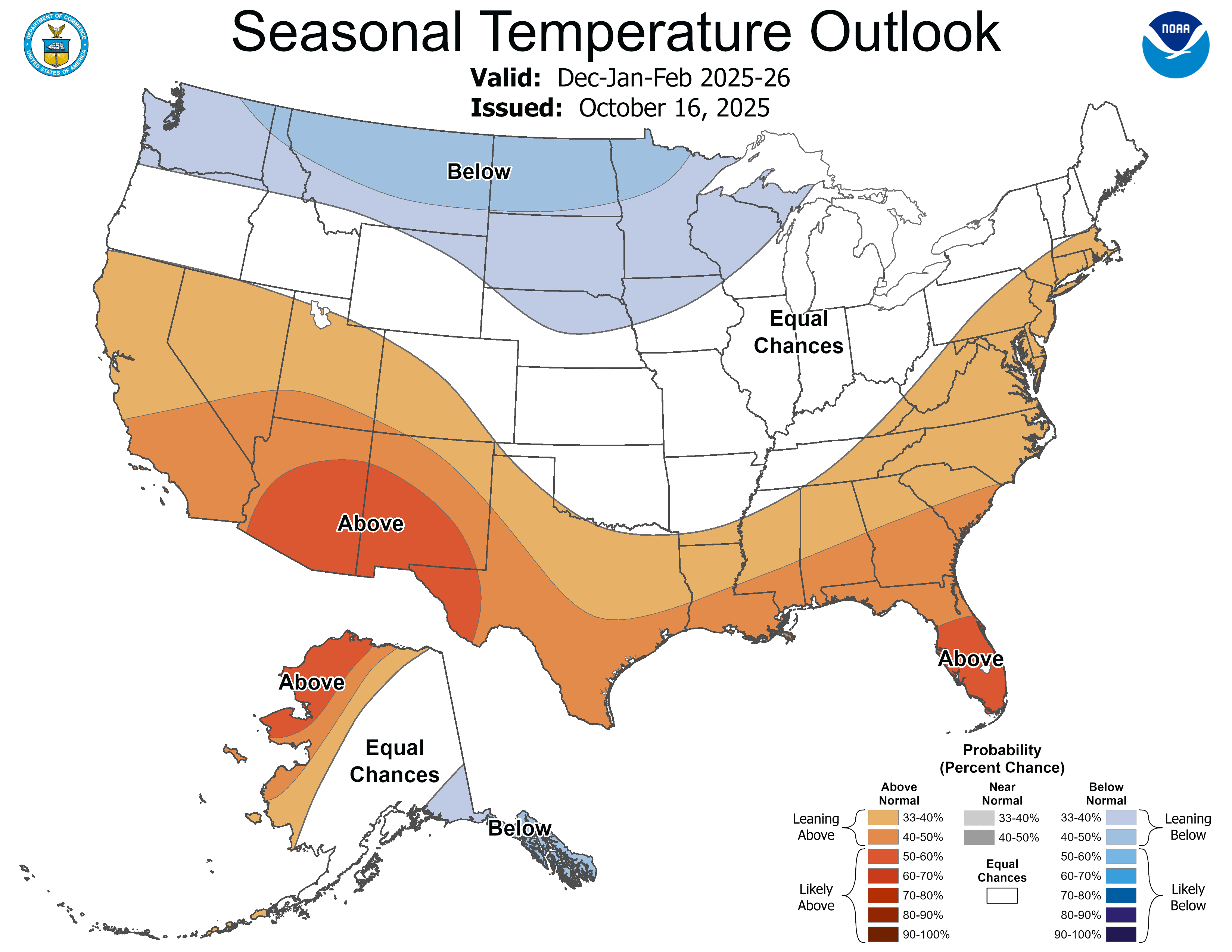
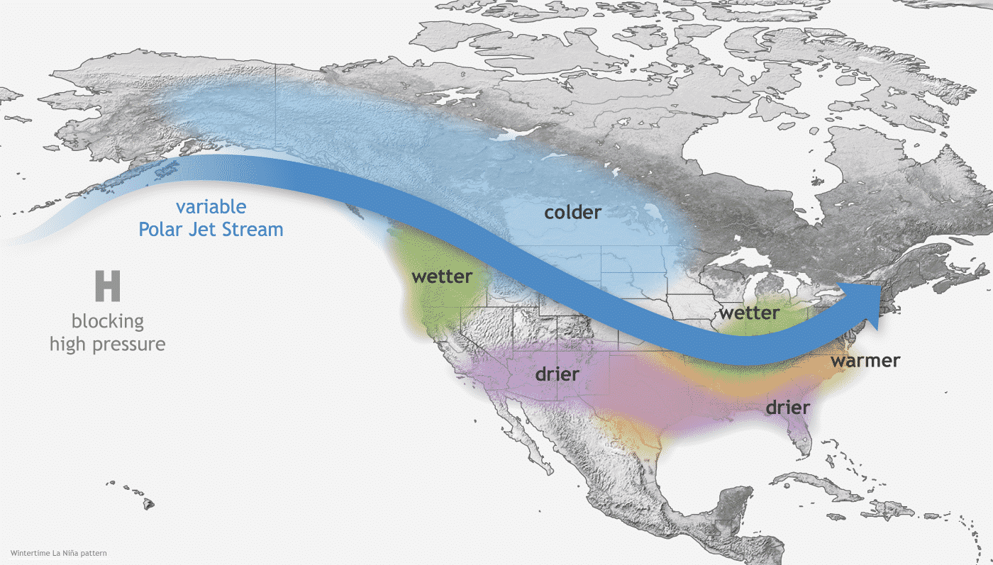
Warm anomalies in the Southern US but also up the East Coast to the Northeast. The areas north of that with EQUAL chances are likely to be the battleground, with some very mild days, offset by cold and potentially brutal cold if the Northern Stream/Polar Vortex does what it did several weeks ago (plunge to the US border), extremely rare in Summer.
The fact that we saw this in August/September makes us dial in some extra cold this Winter based on the tendency for some patterns repeating.
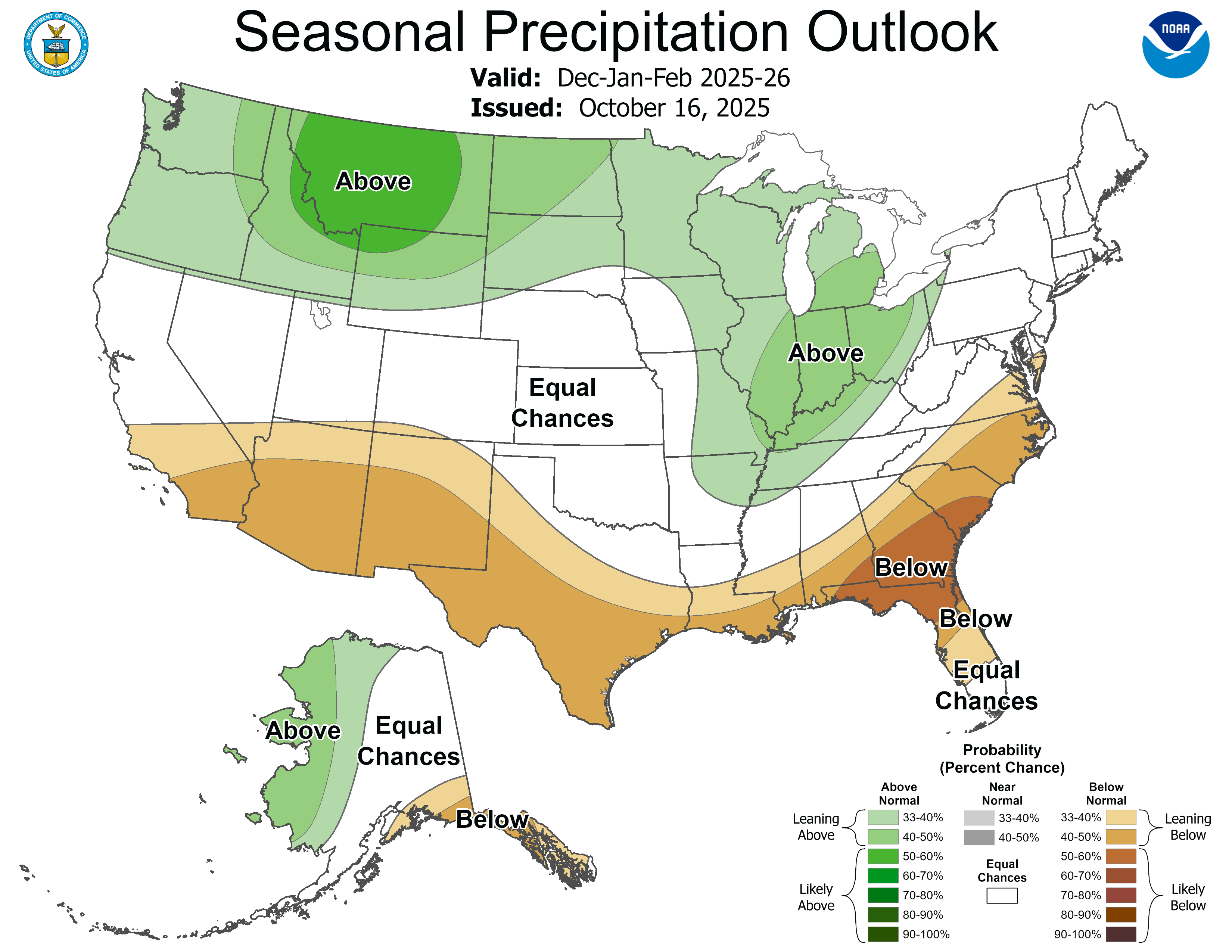
As you might think, where the air mass battleground is, will be the area with the heaviest precip. Much of the green depicted above would be heavy snow. The track of individual storms along the battle ground will determine that.
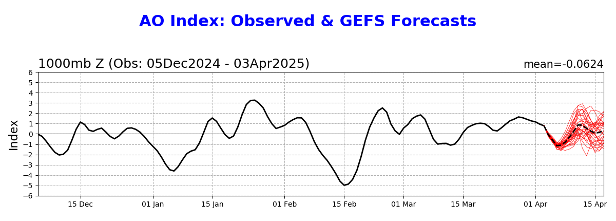
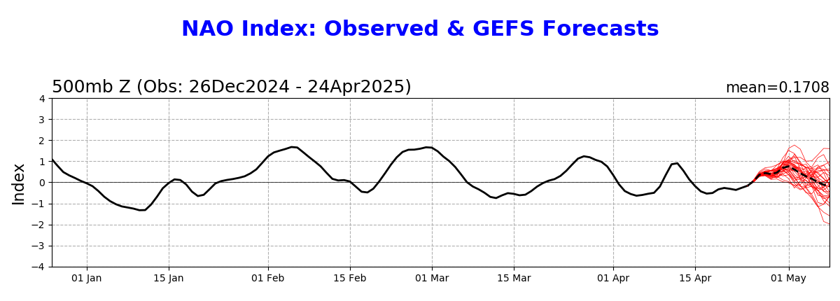
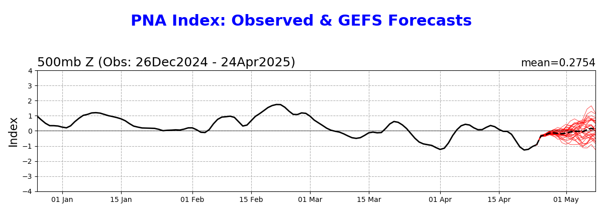
We'll be especially watching the NAO and AO for extreme cold signals(with a big negative magnitude) coming from the Northern Stream! The PNA will often determine how far south they can penetrate.
Arctic Oscillation Index, North Atlantic Oscillation Index, Pacific North American Index.
https://www.cpc.ncep.noaa.gov/products/precip/CWlink/daily_ao_index/ao.shtml
https://www.cpc.ncep.noaa.gov/products/precip/CWlink/pna/nao.shtml
https://www.cpc.ncep.noaa.gov/products/precip/CWlink/pna/pna.shtml
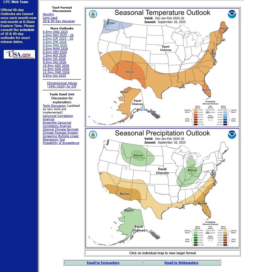
Latest NWS Winter forecast updated late last week.
Long range/seasonal forecasts usually don't have high skill scores but do have value and are much better than just flipping a coin. In this case, the weak La Nina as an atmospheric forcing increases the odds of the patterns below.
I DO agree with this assessment below based on the NWS forecast philosophy which relies heavily on the La Nina analog years.
One thing that should be added. Most of that green shade below will be SNOW! That will especially be so from Detroit to Chicago and especially westward.
Points farther south to the Ohio River with elevated/above precip chances, will be dependent on individual storm tracks and where the boundaries are between air masses at those times and how much cold air has been entrenched at those times.
With more precip in the Winter at a place that averages around 13 inches of snow for the entire season, like Evansville Indiana odds are HIGHER for more snow this Winter.
1 big storm could dump that much by itself!
The La Nina forcing is coming from the tropical Pacific and has most control over the southern stream or the Pacific stream.
The huge wildcard is always the northern stream which determines how much frigid air is dumped into the US or does not get dumped in. That is much more challenging to forecast.
The late August 2025 incursion of the Polar Vortex down to the US border was extremely rare and a feature of the northern stream. The Winter atmosphere is MUCH different than the Summer atmosphere so we shouldn't give that too much weighting but patterns sometimes do tend to repeat.
In the Summer, for instance the highest latitudes are getting the most sunshine to warm them. In the Winter, however they get no sunshine to very weak, low angled sunshine which causes a continual LOSS of heat as they brew colder and colder and colder air.
It's not just the source region of the coldest air on the planet. Temperature contrasts in the cold season between land and water/oceans become totally different compared to the warm season.
So its a completely different weather forecasting ballgame!
Technical discussion:
https://www.cpc.ncep.noaa.gov/products/predictions/long_range/fxus05.html
I like this guy and his comprehensive explanations a great deal!
By Author Andrej Flis
Posted on Published:
Categories Long range / seasonal forecast
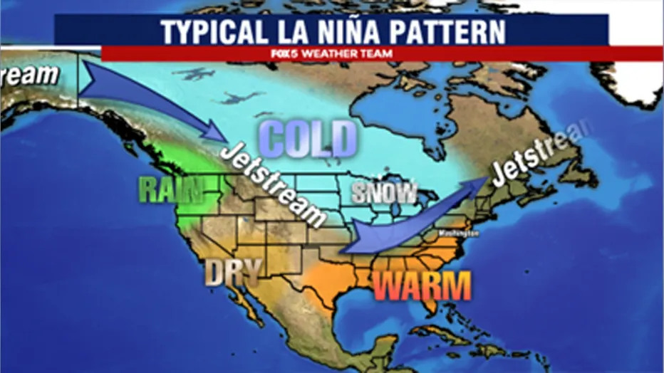
You can see the jet stream redirection in the image below, which shows the average jet stream position in La Niña winters and the resulting weather patterns developing over the United States and Canada. Notice the high pressure in the North Pacific, pushing the jet stream upwards.
ENSO: Recent Evolution,
Current Status and Predictions
ENSO: Recent Evolution,
Current Status and Predictions
Update prepared by:
Climate Prediction Center / NCEP
20 October 2025