Dakota met guy says he has never seen one before. He called it a Low Wake or something very similar to a Hurricane but over land with its intense winds, big rains and rotation. Its what mets live for, once in a lifetime deal
Thanks, mcfarm!
I'll take a look at that when I get the chance.
With regards to once in a life time.............actually its not all that extreme but it is an extreme event.
I'm extremely grateful, however to you for pointing this out because I didn't know about this one and honestly am not that familiar with WAKE LOWS and can gather some information to examine them and this one and pass it on here for all of us to learn something:
This was just last month:
Multiple Wake Lows Bring Wind Gusts 50 to 70 mph to Southeast South Dakota, Southwest Minnesota, Far Northwest Nebraska, and Northwest Iowa
https://www.weather.gov/fsd/MultipleWakeLows05192025
https://en.wikipedia.org/wiki/Wake_low
A wake low, or wake depression, is a mesoscalelow-pressure area which trails the mesoscale high following a squall line.[1] Due to the subsiding warm air associated with the system's formation, clearing skies are associated with the wake low. Once difficult to detect in surface weather observations due to their broad spacing, the formation of mesoscale weather station networks, or mesonets, has increased their detection.[2]Severe weather, in the form of high winds, can be generated by the wake low when the pressure difference between the mesohigh preceding it and the wake low is intense enough.[3] When the squall line is in the process of decay, heat bursts can be generated near the wake low. Once new thunderstorm activity along the squall line concludes, the wake low associated with it weakens in tandem.
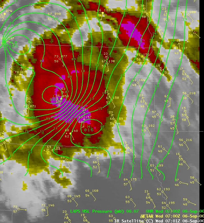
Image showing the pressure pattern around an organized thunderstorm complex. Near the strong wake low, strong winds and a temperature spike were recorded
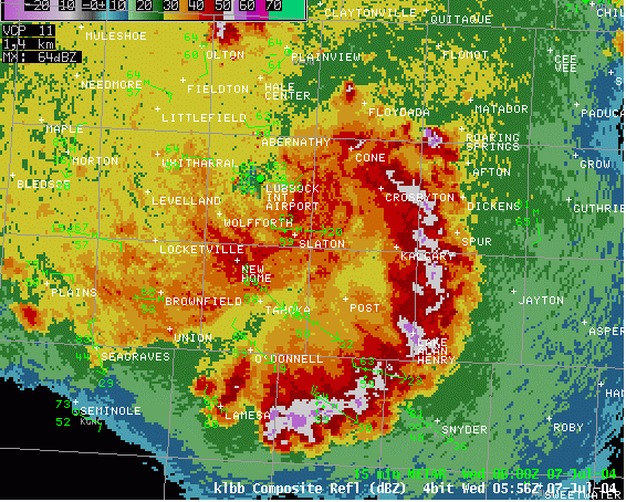
This radar image shows the location of a wake low wind event near Tahoka, Texas. Note the minimum in the radar returns in that area.
++++++++++++=
Excellent discussion here!!!
Exploring the Science Behind Wake Low and its Forecasting Challenges
https://www.numberanalytics.com/blog/wake-low-deep-dive-science-and-forecasting-challenges
The formation of Wake Low is attributed to the interaction between the thunderstorm or MCS and the surrounding environment. As the storm system moves, it creates a region of low pressure near the surface due to the upward motion of air and the subsequent collapse of the storm's trailing edge. This process is often accompanied by a significant drop in pressure, sometimes exceeding 5 hPa in a matter of hours.
The dynamics of Wake Low formation can be understood by examining the following factors:
OK, examining the actual reports suggests that this one was actually VERY extreme! More in a minute.
This wake low in North Dakota is producing a surface pressure of 954 MB and getting lower with reports of ears popping. 105-115 mph winds have been reported. Very similar to a strong hurricane. Keep in mind -- the derecho has left North Dakota.This is the craziest wake lows ever. This is one for the history books.
++++++++++++++++
Hundreds of thousands of households are dealing with power outages Saturday morning, many are also dealing with significant tree damage, after a derecho ripped through North Dakota and Minnesota Friday night into Saturday morning. The derecho brought wind gusts of 70 -105 mph to the region spanning over 400 miles, producing an impressive shelf cloud along it's leading edge (video below).
Hundreds of thousands of households are dealing with power outages Saturday morning, many are also dealing with significant tree damage, after a derecho ripped through North Dakota and Minnesota Friday night into Saturday morning. The derecho brought wind gusts of 70 -105 mph to the region spanning over 400 miles, producing an impressive shelf cloud along it's leading edge (video below).
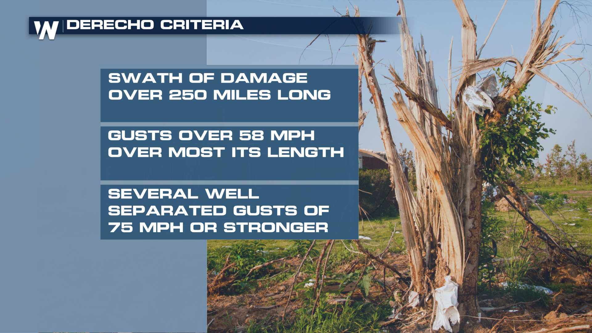
A derecho is a long-lived severe wind event, with specific criteria about the length and width of the damaging wind swath. The SPC has a detailed page dedicated to these destructive wind storms. Several typically occur each year, through they can vary in intensity and area. A notable derecho ripped through Des Moines in 2020, producing hurricane force winds and widespread damage.
All criteria appear to have been met Friday night and Saturday morning to classify this event as a derecho. Regardless, widespread wind damage has been reported with many trees and powerlines down. Several tornadoes did occur in addition to the straight-line winds.
Wind gusts in North Dakota and Minnesota (as well as northern South Dakota) were impressive, many over hurricane strength. A wake-low also developed behind the leading edge, producing severe strength winds (58+ mph) in some locations for over an hour!
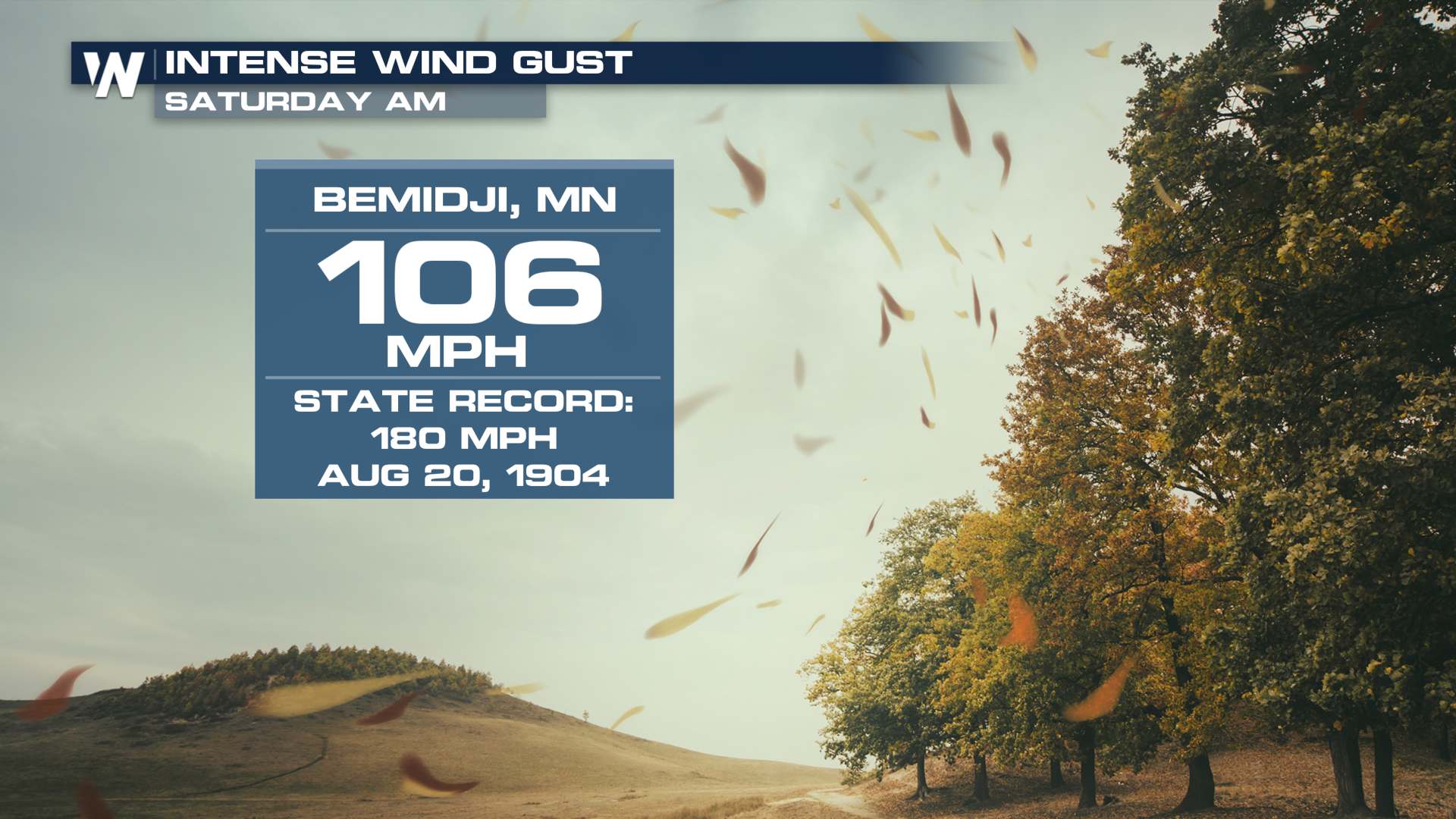
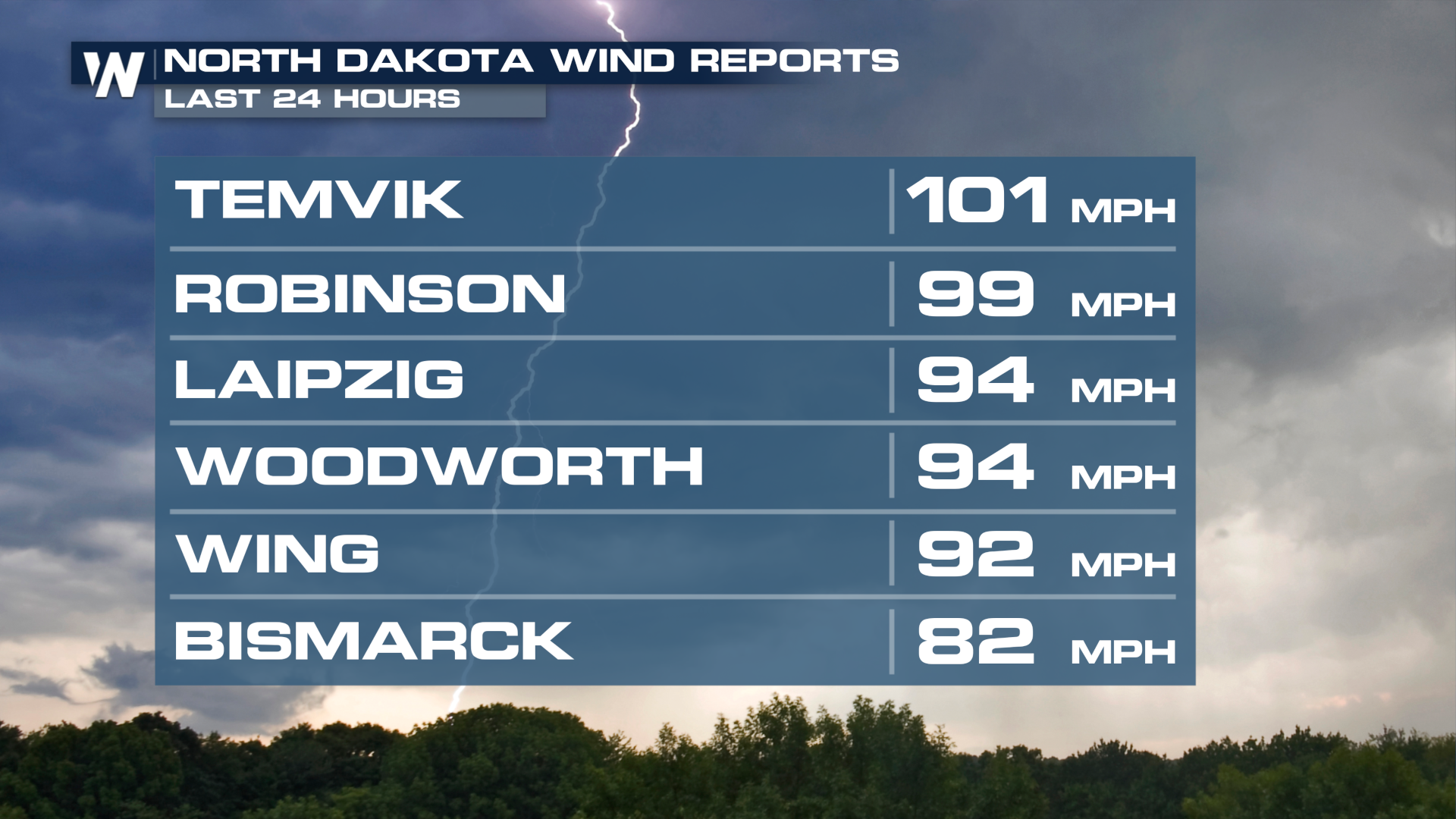 Bemidji, Minnesota was hit particularly hard in the overnight hours as a intense bout of winds moved through the area, with a tornado potentially embedded in the circulation. The Bemidji Regional Airport reported a gust to 106 mph, with widespread damage reported in the area.
 The widely spanning severe winds have left hundreds of thousands of households in the dark as of Saturday morning, with some counties reporting well over 60-60% of customers without power. As a reminder, if you're going to run a generator to power anything keep it at least 25 feet away from any opening in your home, like windows and doors.
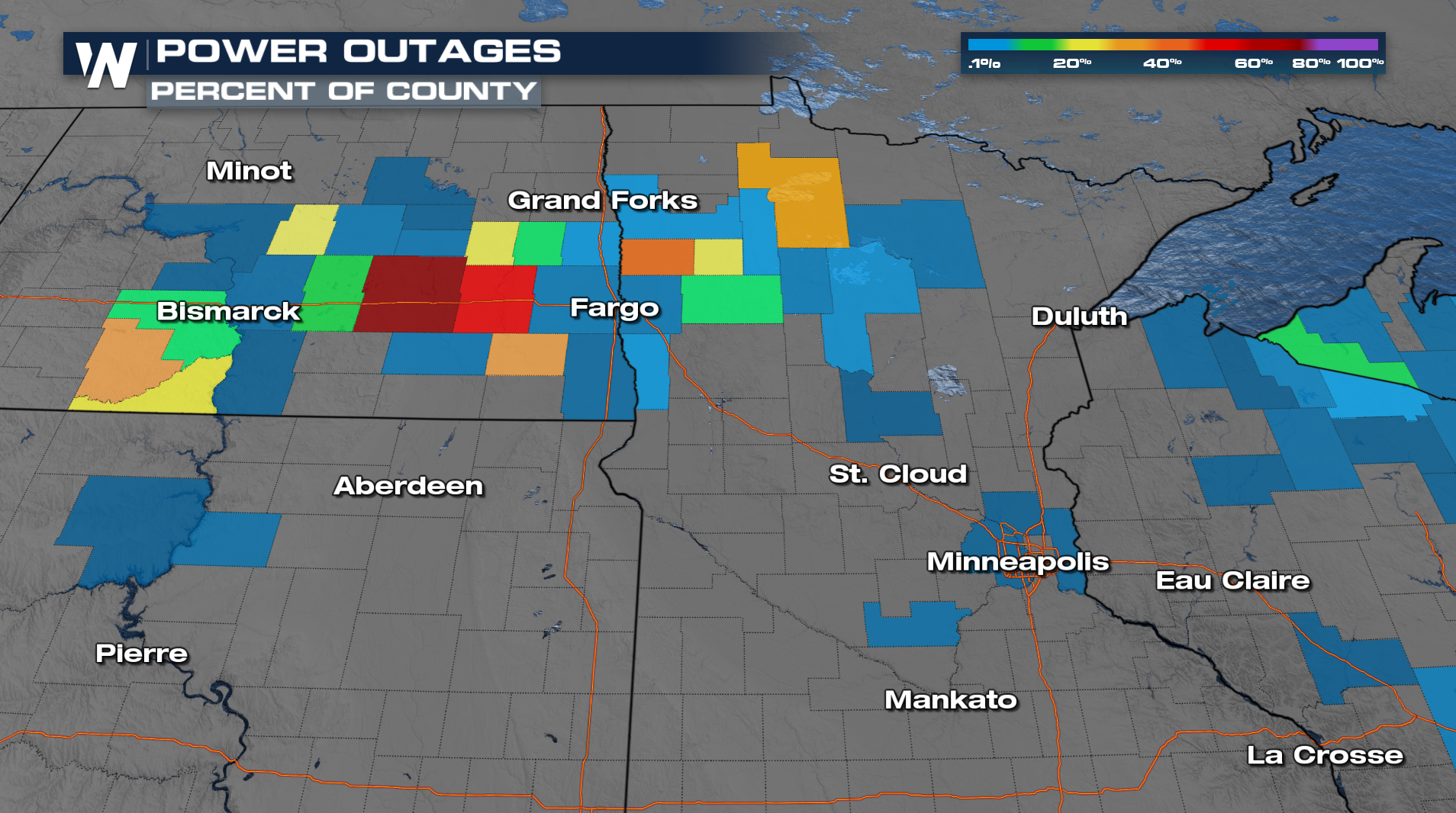
Thanks again, mcfarm!
This is easily our post/thread of the week!!!
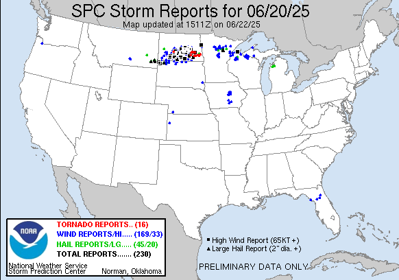
https://www.spc.noaa.gov/climo/reports/250620_rpts.html
that is extremely interesting reading MM. Lots of very rare mother nature stuff that makes it clear who is in charge
Thank YOU, mcfarm!
I had no idea this had happened.
https://en.wikipedia.org/wiki/Derecho
A derecho (/dəˈɹeɪ.t͡ʃoʊ/ⓘ, from Spanish: derecho[deˈɾetʃo], 'straight')[1] is a widespread, long-lived, straight-line wind storm that is associated with a fast-moving group of severe thunderstorms known as a mesoscale convective system.[2]
Derechos cause hurricane-force winds, heavy rains, and flash floods. In many cases, convection-induced winds take on a bow echo (backward "C") form of squall line, often forming beneath an area of diverging upper tropospheric winds, and in a region of both rich low-level moisture and warm-air advection. Derechos move rapidly in the direction of movement of their associated storms, similar to an outflow boundary (gust front), except that the wind remains sustained for a greater period of time (often increasing in strength after onset), and may reach tornado- and hurricane-force winds. A derecho-producing convective system may remain active for many hours and, occasionally, over multiple days.
A warm-weather phenomenon, derechos mostly occur in summer, especially during June, July, and August in the Northern Hemisphere, or March, April, and May in the Southern Hemisphere, within areas of moderately strong instability and moderately strong vertical wind shear. However, derechos can occur at any time of the year. They are equally likely during day and night times.
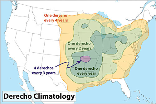
This image shows derecho frequency for the lower 48 United States
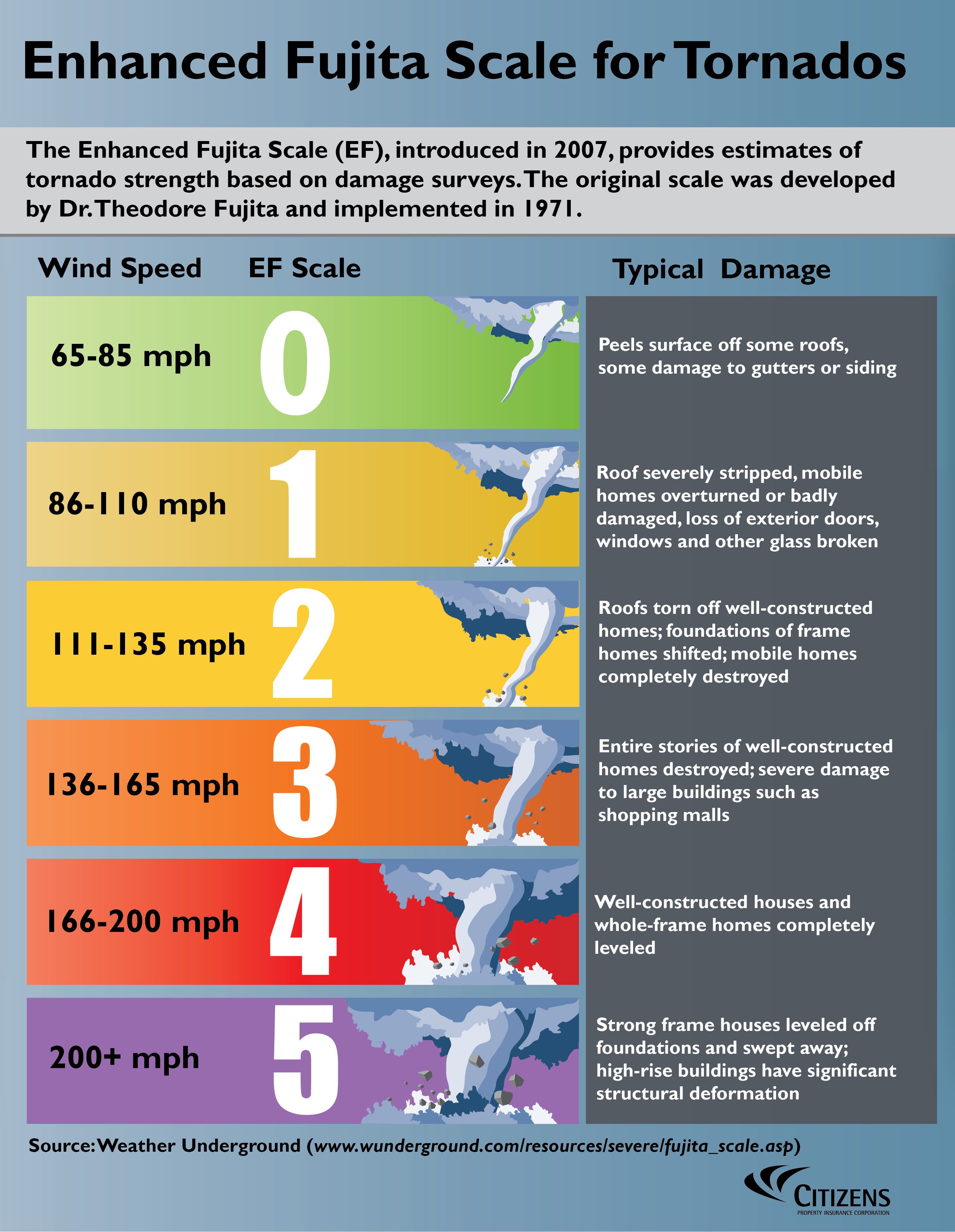
The tornado that struck the Enderlin area has been given a preliminary rating of EF-3+.
A 150 mph tornado from an EF3 does 256 times more damage than a 75 mph tornado.
++++++++++++++++++++++
https://en.wikipedia.org/wiki/Enhanced_Fujita_scale
| EFU | Unknown | No surveyable damage |
|---|---|---|
| EF0 | 65–85 mph | Light damage |
| EF1 | 86–110 mph | Moderate damage |
| EF2 | 111–135 mph | Considerable damage |
| EF3 | 136–165 mph | Severe damage |
| EF4 | 166–200 mph | Devastating damage |
| EF5 | >200 mph | Incredible damage |
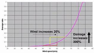
Here's the deal on wind and damage and why an EF3+ tornado can cause so much damage
As wind increases the damage massively increases on an exponential scale. This applies to ALL wind.
Severe storms and hurricanes and especially tornadoes that have the strongest winds of all, which means the tornadoes with winds over 150mph have incredible damage.
+++++++++++
+++++++++++++++++++++
A 150mph wind does 256X more damage than a 75 mph wind. Let's repeat that. A 150mph wind does 256x more damage than a 75 mph wind!
https://www.weather.gov/bis/SevereWx06202025
++++++++++++
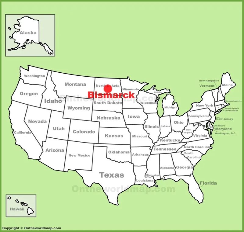
One of the interesting things for me was looking at the images of the actual storm that were taken so late in the evening but under daylight conditions because it was the longest day of the year and so far north.
https://www.timeanddate.com/sun/usa/bismarck
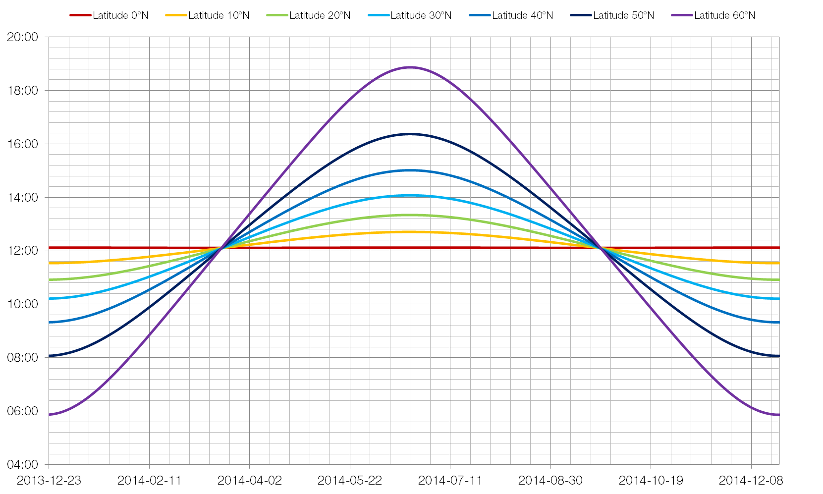
The sunset was at 9:40 pm and day length was 15 hours and 52 minutes long!
The farther north one goes in Summer, the longer the days(north of the Arctic Circle that equates to 24 hour days.
+++++++++++++++++++++++++++++++++++++=
Bismark, ND has a latitude of 46.8 degrees North.
https://www.latlong.net/place/bismarck-nd-usa-7497.html
http://wordpress.mrreid.org/2014/10/19/rate-of-change-of-day-length-with-latitude/
Evansville, IN is 40 Deg. N our longest day was 14 hours and 16 minutes long
Detroit, MI is 42.3 longest day was 15 hours and 20 minutes
Bismark, ND has a latitude of 46.8 degrees North. longest day 15 hours 52 minutes
Anchorage AK has a latitude of 61.2 Deg N. longest day is 19 hours and 21 minutes
Another round of severe weather Friday in ND. Crazy storm chaser video from this one!
This person actually was misjudging the location of the tornado on several occasions and is likely they didn't get killed!
+++++++++++++++++++++
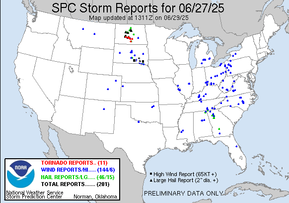
https://www.spc.noaa.gov/climo/reports/250627_rpts.gif
