I just poured out 5.5 inches of rain in our rain gauge, most of it, 5"+ fell in less than 2 hours. It was filled to the top!!!
Some very minor flooding in the basement which has been easily sucked up with our shop vac.
| NWS Forecast Office Paducah, KY - National Weather Service US Dept of Commerce National Oceanic and Atmospheric Administration National Weather Service Paducah, KY 8250 Kentucky Highway 3520 West Paducah, KY 42086-9762 www.weather.gov |
| WWA Summary by Location for 37.99N 87.59W with INZ086/INC163/INZ086 - National Weather Service NOAA National Weather Service. Hazardous Weather Outlook Hazardous Weather Outlook National Weather Service Paducah KY Issued by National Weather Service Quad Cities IA IL 327 PM CDT Fri Apr 4 2025 ILZ075>078-080>094-INZ081-082-085>088-KYZ001>022-MOZ076-086-087- 100-107>112-114-052030- Jefferson-Wayne IL-Edwards-Wabash-Perry IL-Franklin-Hamilton- White-Jackson-Williamson-Saline-Gallatin-Union ... forecast.weather.gov |
Flash Flood Statement National Weather Service Paducah KY 700 PM CDT Fri Jun 13 2025
INC163-140315- /O.CON.KPAH.FF.W.0062.000000T0000Z-250614T0315Z/ /00000.0.ER.000000T0000Z.000000T0000Z.000000T0000Z.OO/ Vanderburgh IN- 700 PM CDT Fri Jun 13 2025
...FLASH FLOOD EMERGENCY FOR WESTERN EVANSVILLE INCLUDING THE MECHANICSVILLE, RED BANK, AIRPORT AND HARWOOD NEIGHBORHOODS...
...FLASH FLOOD WARNING REMAINS IN EFFECT UNTIL 1015 PM CDT THIS EVENING FOR CENTRAL VANDERBURGH COUNTY...
At 700 PM CDT, 4 to 5 inches of rain has fallen from near USI northeastward to near the Evansville Airport. Numerous water rescues continue where individuals are trying to cross flooded roadways. Water is approaching homes and businesses in parts of western Evansville. Heavy rain has ended but flooding will remain significantly dangerous for the next few hours. Motorists are urged to avoid travel in the emergency area and do not enter into flooded areas.
This is a FLASH FLOOD EMERGENCY for western Evansville including the Mechanicsville, Red Bank, Airport and Harwood neighborhoods. This is a PARTICULARLY DANGEROUS SITUATION. SEEK HIGHER GROUND NOW!
HAZARD...Life threatening flash flooding. Thunderstorms producing         flash flooding.
SOURCE...Emergency management reported.
IMPACT...This is a PARTICULARLY DANGEROUS SITUATION. SEEK HIGHER         GROUND NOW! Life threatening flash flooding of low water         crossings, small creeks and streams, urban areas,         highways, streets and underpasses.
Some locations that will experience flash flooding include...  Evansville and Kasson.
PRECAUTIONARY/PREPAREDNESS ACTIONS...
the same sad thing here on top of young crops that will now suffocate under water. 2 of those rains nearby today. one had over 2 inches in 45 minutes and the other nearly identical just to the north. Weather guys say next 4 days could be brutal.
Thanks, mcfarm!
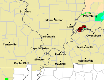
Here the summary from our NWS in Evansville. This rain fell in less than 2 hours late last Friday afternoon.
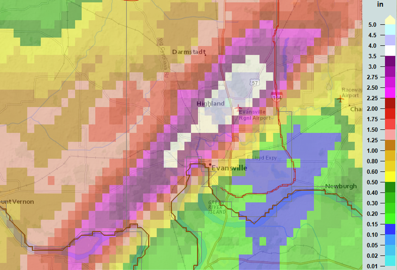
There's 1 blue box in the epicenter which represents 4.5 inches of rain on the map below.
We are 2 miles northeast of that blue box and got 5" inches of rain!!
https://www.weather.gov/pah/2025June13FloodSevere
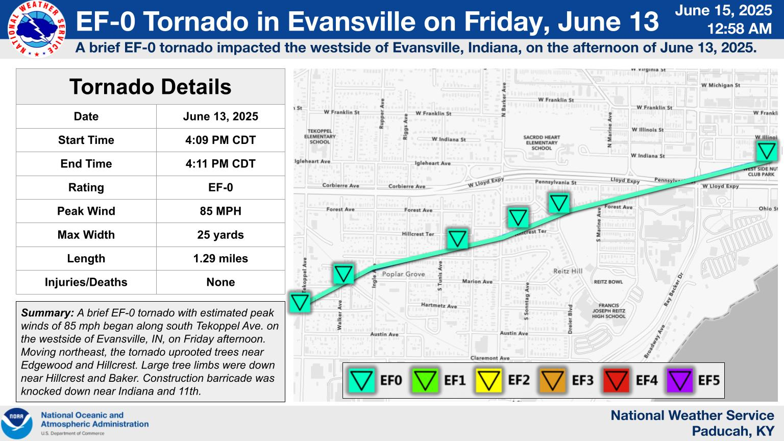
We also had a weak tornado hit our West side at the start of the excessive rain event.
++++++++++++++++++++++
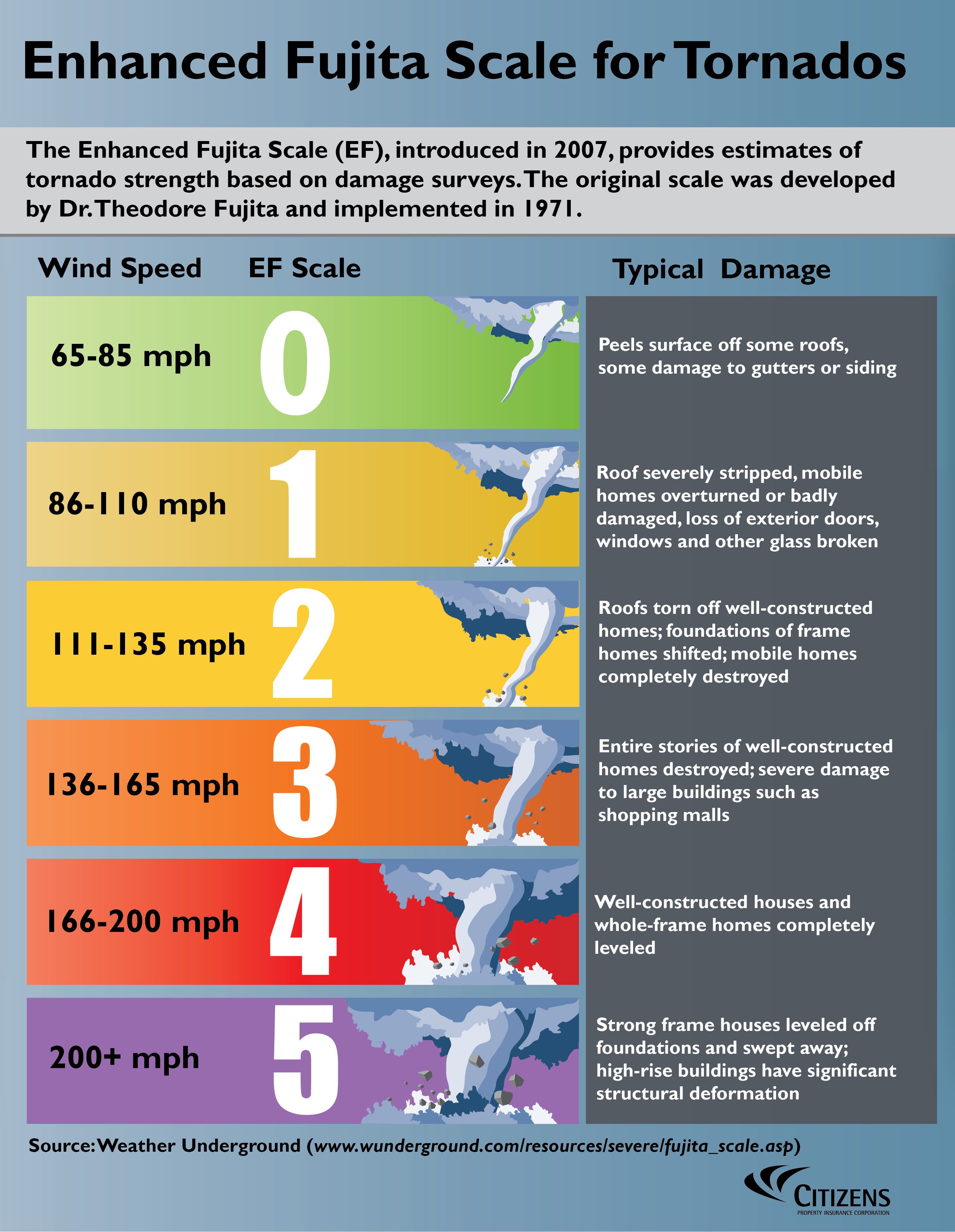
https://en.wikipedia.org/wiki/Enhanced_Fujita_scale
| EFU | Unknown | No surveyable damage |
|---|---|---|
| EF0 | 65–85 mph | Light damage |
| EF1 | 86–110 mph | Moderate damage |
| EF2 | 111–135 mph | Considerable damage |
| EF3 | 136–165 mph | Severe damage |
| EF4 | 166–200 mph | Devastating damage |
| EF5 | >200 mph | Incredible damage |
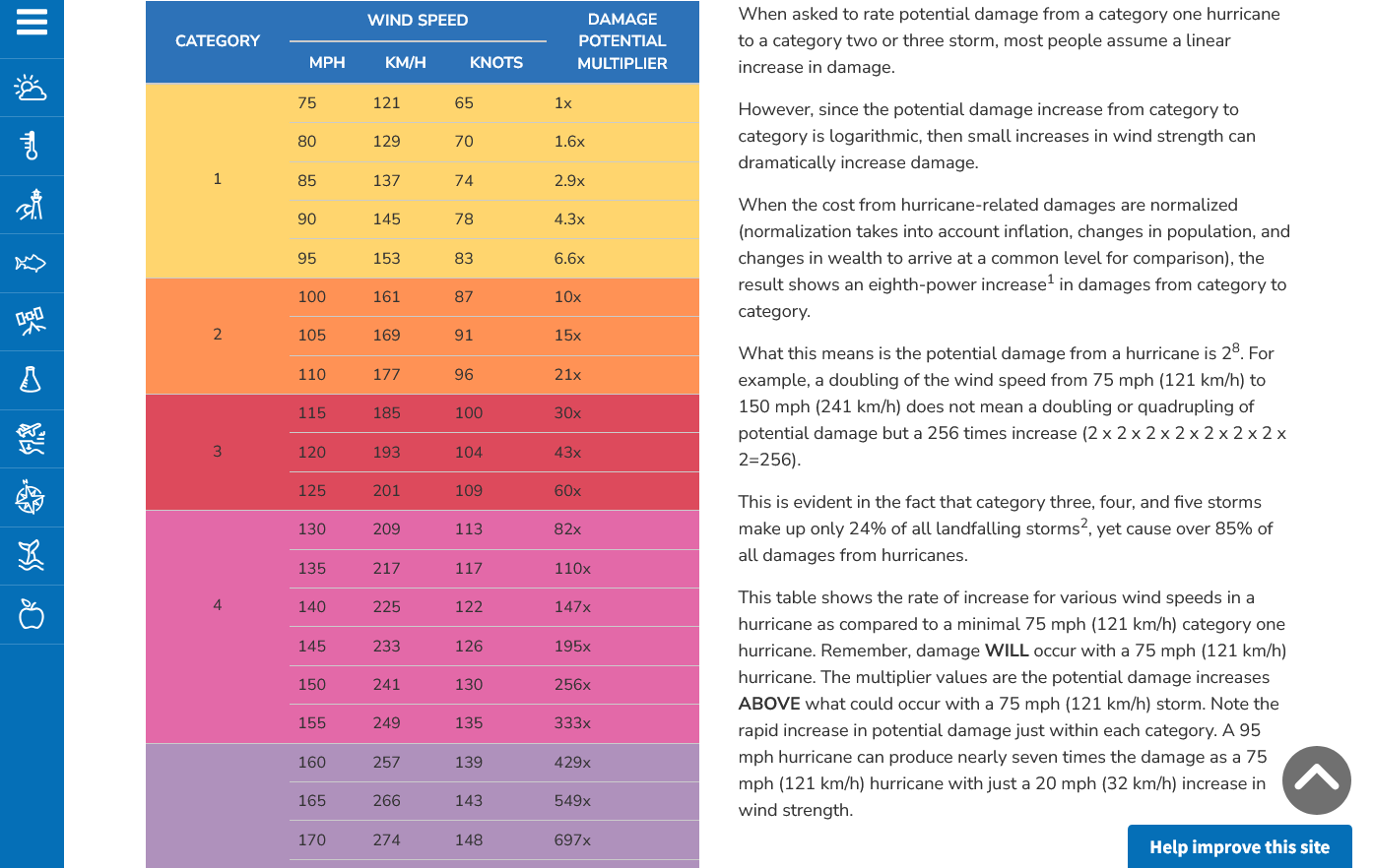
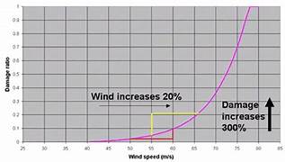
Here's the deal on wind and damage and why this tornado did not cause much damage
As wind increases the damage massively increases on an exponential scale. This applies to ALL wind.
Severe storms and hurricanes and especially tornadoes that have the strongest winds of all, which means the tornadoes with winds over 150 mph have incredible damage.
+++++++++++
+++++++++++++++++++++
A 150 mph wind does 256X more damage than a 75 mph wind. Let's repeat that. A 150 mph wind does 256x more damage than a 75 mph wind!
Hurricane Damage Potential
https://www.noaa.gov/jetstream/tc-potential