")
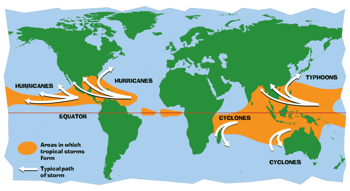
Hurricane season 2025 is almost here and now the National Oceanic and Atmospheric Administration has a prediction about how bad the season may be.
Specifically, NOAA is forecasting a range of 13 to 19 total named storms (winds of 39 mph or higher). Of those, 6 to 10 are forecast to become hurricanes (winds of 74 mph or higher), including 3 to 5 major hurricanes (Category 3, 4 or 5; with winds of 111 mph or higher).
The forecast says there's a 60% chance of an above average season.
Previous thread:
Time to worry about 1930s type drought?
Started by tjc - May 15, 2025, 1:12 p.m.
https://www.marketforum.com/forum/topic/111856/
What La Nina?? April 26, 2025-Summer Outlook
Started by metmike - April 26, 2025, 4:15 p.m.
https://www.marketforum.com/forum/topic/111494/
MUCH more to come as the 2025 hurricane season doesn't even start until next month!!!
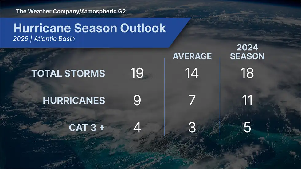
Get ready for another active Atlantic hurricane season, with as many as 17 storms expected, experts from Colorado State University said in their initial forecast released Thursday morning.
Of those 17 storms, researchers forecast that nine will become hurricanes. A typical year averages about 14 tropical storms, with seven of them spinning into hurricanes, based on weather records that date from 1991 to 2020.
+++++++++++++
https://weather.com/storms/hurricane/news/2025-04-16-hurricane-season-outlook-twc-april
+++++++++++
From WeatherBell;
April 7, 2025
Forecast according to the Power & Impact Scale
Named Storms: 15-19
Category 1 or greater hurricanes: 7-9
Category 2.5 or greater (major in the Power & Impact Scale): 3
Saffir-Simpson Hurricane Wind Scale Forecast
Named Storms: 15-19
Total Hurricanes: 7-9
Major Hurricanes: 2-3
ACE Index: 120-150
Impact Forecast
Tropical Storm Conditions: 5-7
Total Hurricanes: 3-4
Major Hurricanes: 1-2
Back to NOAA's just released forecast:
https://www.noaa.gov/news-release/noaa-predicts-above-normal-2025-atlantic-hurricane-season
")
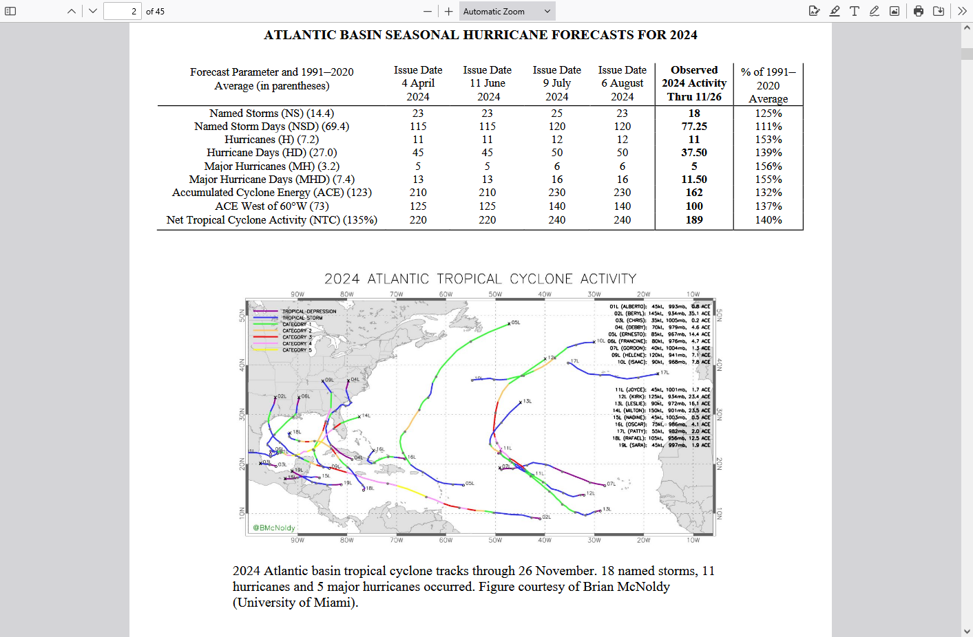
SUMMARY OF 2024 ATLANTIC TROPICAL CYCLONE ACTIVITY AND
VERIFICATION OF AUTHORS’ SEASONAL AND TWO-WEEK FORECASTS
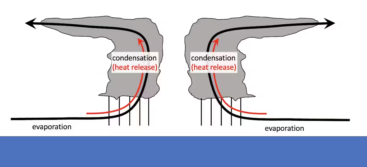
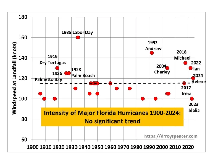
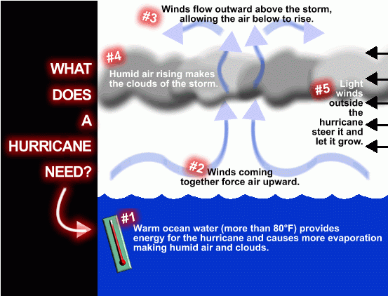
The temperature of both the ocean and atmosphere are critical to hurricane development.
Hurricanes are powered by the release of heat when water that evaporates from the ocean’s surface condenses into the storm’s rain.
A warmer ocean produces more evaporation, which means more water is available to the atmosphere. A warmer atmosphere can hold more water, which allows more rain. More rain means more heat is released, and more heat released means stronger winds.
+++++++++++++
metmike: An increase in temperature of 1 Deg. C (almost 2 Deg. F) allows the atmosphere to hold 7% more moisture. Which would equate to a potential for 7% heaver rains. 10.0 inches of rain can become 10.7 inches of rain, all other things being equal.
What about peak winds?
Scientists also have high confidence that wind speeds will increase in a warming climate and that the proportion of storms that intensify into powerful Category 4 or 5 storms will increase. Similar to rainfall rates, increases in intensity are based on the physics of extreme rainfall events.
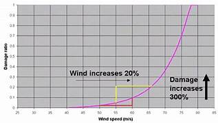
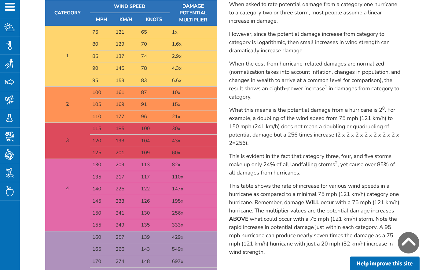
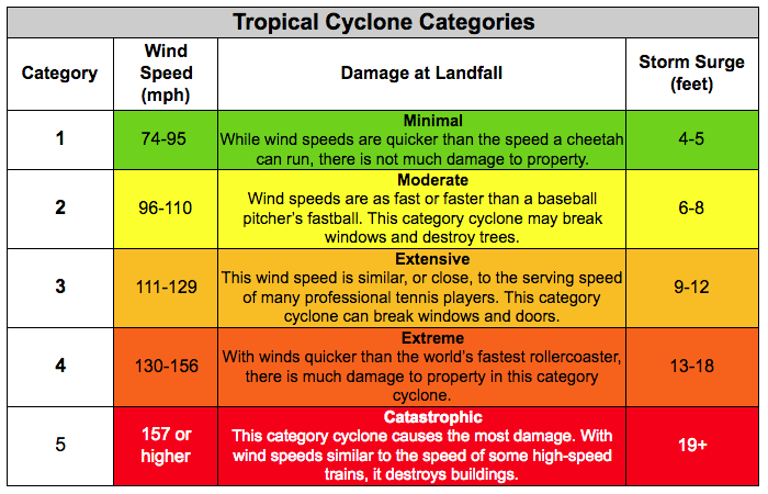
Damage is exponentially related to wind speed, so more intense storms can have a bigger impact on lives and economies. The damage potential from a Category 4 storm with 150 mph winds, like Ian at landfall, is roughly 256 times that of a category 1 storm with 75 mph winds.
+++++++++++
metmike: This means that an increase in wind speed of 10 mph, increases damage on an EXPONENTIAL/LOGARITHMIC SCALE and isn't added to the damage, the same way that more moisture equates to more rain using a LINEAR SCALE!
For instance, The added 10 mph, from 100 mph winds to 110 mph winds will DOUBLE the damage potential!!
Here's the deal on wind and damage.
As wind increases the damage massively increases on an exponential scale. This applies to ALL wind.
Severe storms and hurricanes and especially tornadoes that have the strongest winds of all, which means the tornadoes with winds over 150 mph have incredible damage.
+++++++++++
+++++++++++++++++++++
A 150 mph wind does 256X more damage than a 75 mph wind. Let's repeat that. A 150 mph wind does 256x more damage than a 75 mph wind!
Hurricane Damage Potential
https://www.noaa.gov/jetstream/tc-potential
MEDIA ADVISORY: Hurricane Milton Historic, Not Unprecedented
https://wattsupwiththat.com/2024/10/08/media-advisory-hurricane-milton-historic-not-unprecedented/
Storm of similar size and strength hit Tampa Bay area in 1848 and 1921 when human contributions to carbon dioxide in atmosphere was negligible
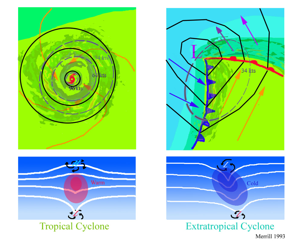
The physics/dynamics of a tropical system are much different than an extra-tropical system. A powerful jet stream in an EXTRATROPICAL storm contributes to it being STRONGER. A stronger jet stream or even modest upper level winds in a tropical system KILLS IT!
Here's some great explanations:
https://www.youtube.com/watch?v=ru5SX9n2qRk
https://www.alabamawx.com/?p=195936
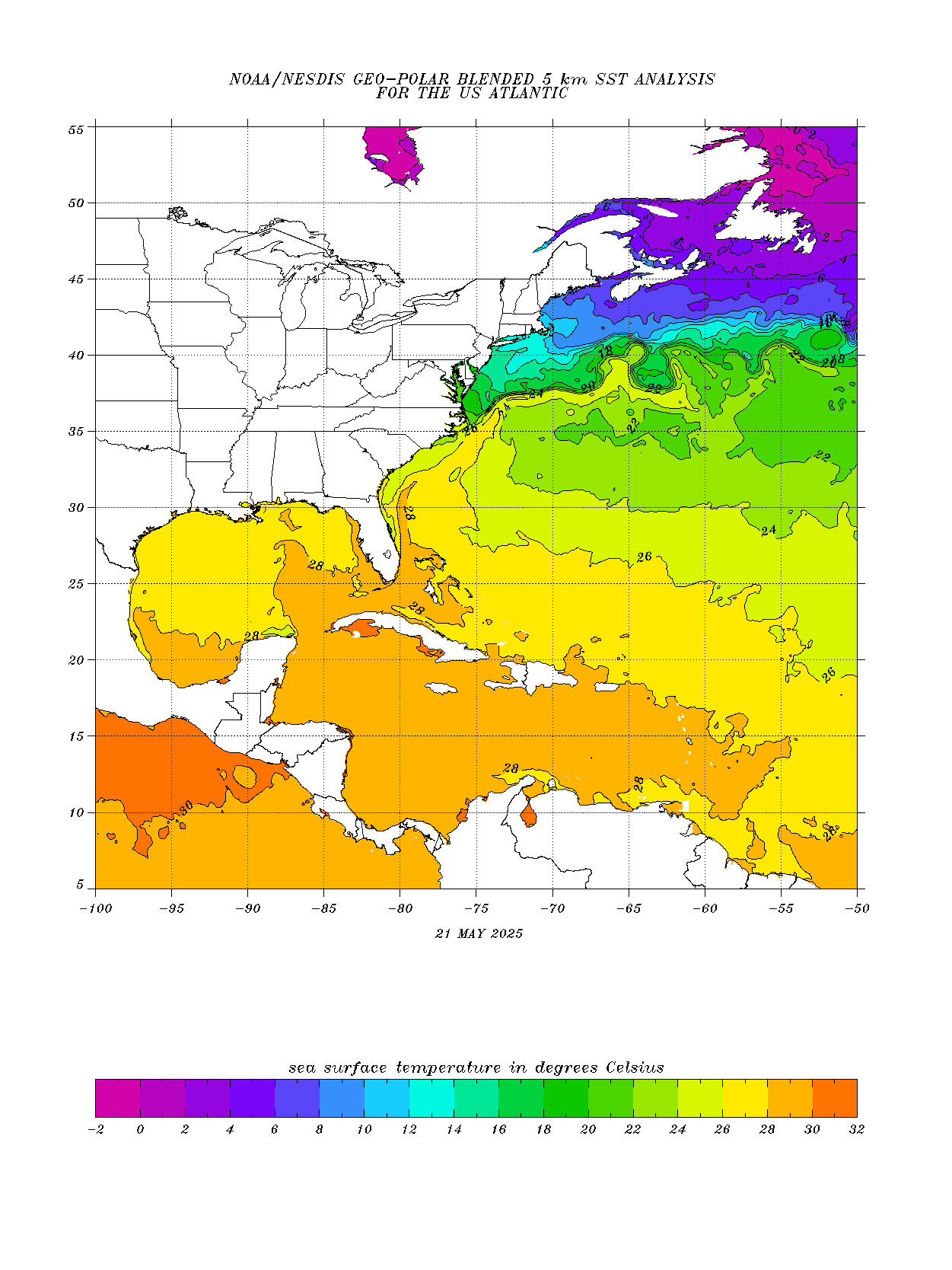
Very warm water also favorable for rapid intensification, is why early season forecasts are hurricane bullish
https://www.ospo.noaa.gov/products/ocean/sst/anomaly/
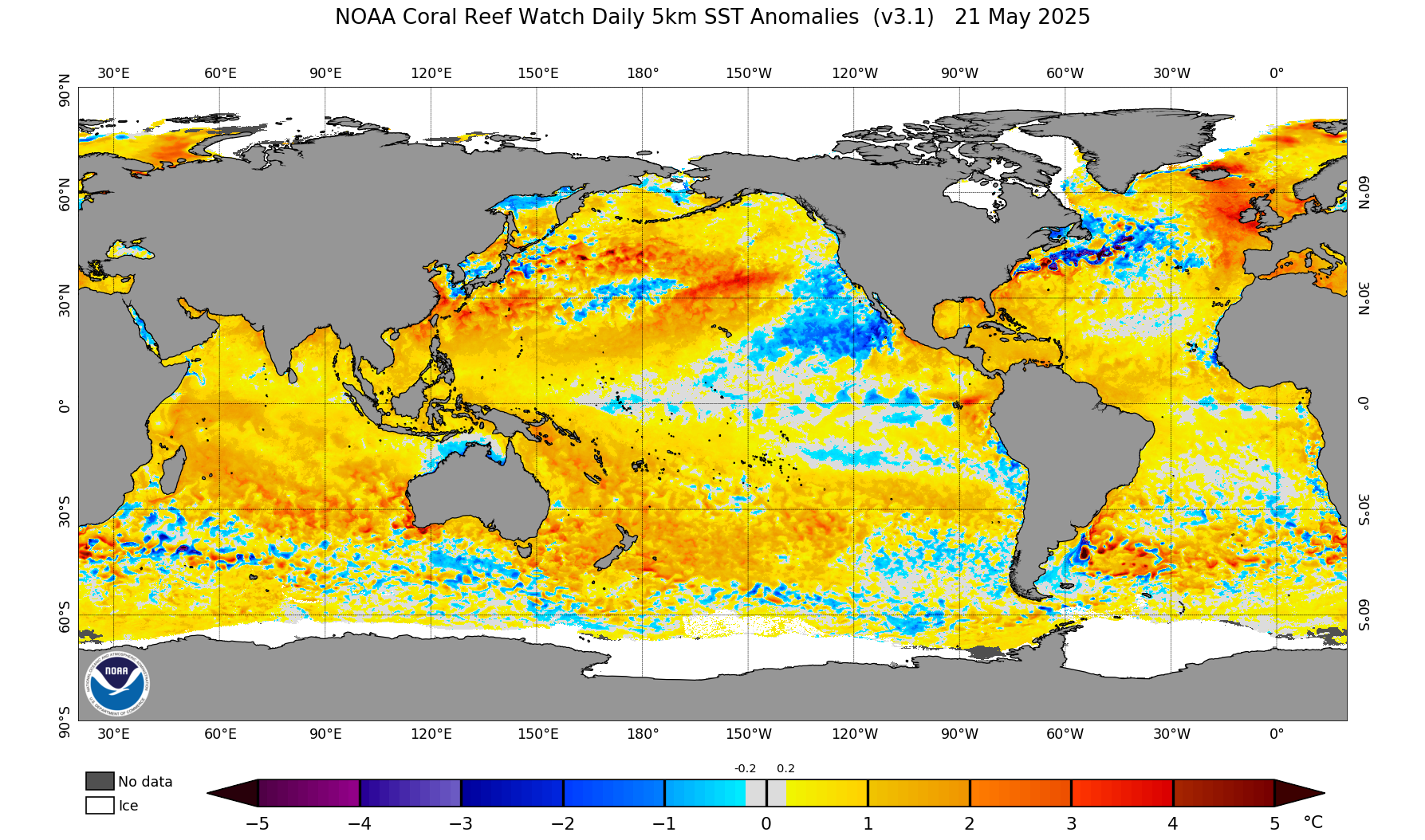
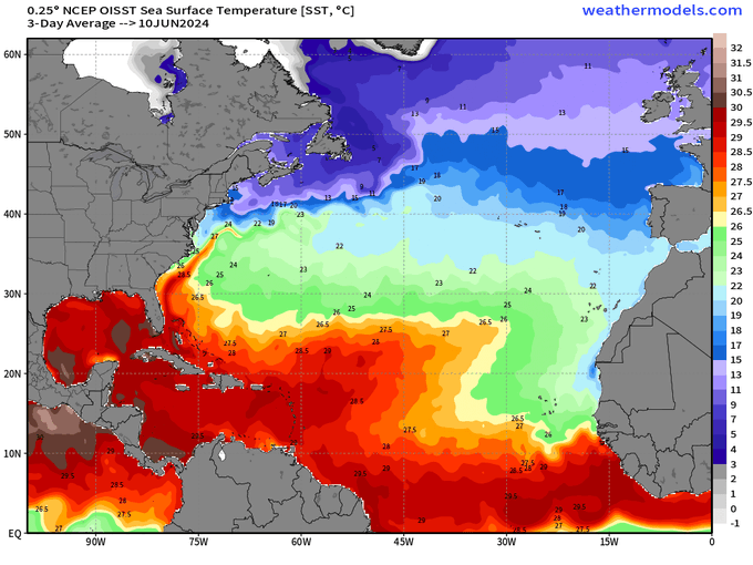
26+ Deg. C is needed to fuel a hurricane(79+ Deg. F)
So temperatures right now in the Caribbean, southern/eastern Gulf of Mexico and surrounding areas are already favorable for a weak hurricane right now but other conditions are currently unfavorable.
https://www.ospo.noaa.gov/data/sst/contour/usatlant.fc.gif
https://mynasadata.larc.nasa.gov/basic-page/hurricane-dynamics
Hurricane Facts
Needed conditions to make a hurricane:
Great sites for hurricane information:
https://www.tropicaltidbits.com/storminfo/
https://x.com/RyanMaue/highlights
·
Tropical Update | June 12, 2025 Ocean temperatures are significantly cooler across the Tropical Atlantic than this time last year when most seasonal forecasts greatly overestimated Atlantic tropical storm activity. Amazing to see this year-on-year change.
Nothing going on right now. Last week, we had the tiniest of named storms well out in the Atlantic:
Maybe the tropics will become much more active in July?
https://www.nhc.noaa.gov/gtwo.php?basin=atlc&basin=atlc&fdays=7
 |
+++++++++++++++
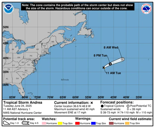
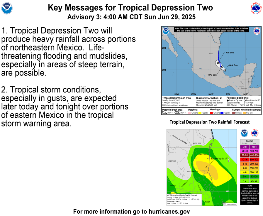
Sunday Morning: Maybe just barely getting the name, Barry before making landfall.
https://www.nhc.noaa.gov/graphics_at2.shtml?start#contents


